#MappingTheFuture
Explore tagged Tumblr posts
Visit Tumblr Blog
Explore Tumblr blogs with no restrictions, modern design and the best experience.
Last Seen Tumblr Blogs


Fun Fact
There are dozens of funny blogs to kill time on Tumblr.
Text
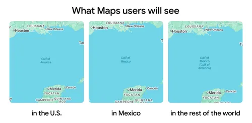
Gulf of America name change in the U.S. — what you’ll see in Maps click down to see more
#GulfOfAmerica#USMaps#NameChange#GeographyNews#MapChanges#AmericanHistory#USPolitics#NewMapNames#GulfOfAmericaChange#GeographyLovers#MappingTheFuture#WorldNews#USGeography#MapUpdates#ChangeInMaps#MapLovers#GeographyTrivia#TrendingNow#BreakingNews#Geopolitics
0 notes
Text
Happy New Year from Team CyberSWIFT!
As we step into another exciting year, we extend our heartfelt wishes to you and your family for a year filled with joy, success, and new opportunities. May 2025 bring you endless happiness, good health, and prosperity. Let’s continue to innovate, grow, and create incredible moments together!
#HappyNewYear#TeamCyberSWIFT#Welcome2025#NewYearWishes#2025#CyberSWIFT#GISSolutions#GeospatialTechnology#MappingTheFuture#GISInnovation#SmartMapping#SpatialAnalysis#GISForGood#GeoSolutions#GeospatialInsights
0 notes
Text
Mapping from the Clouds: The Impact of Drones in Surveys
In recent years, technological advancements have revolutionized the field of surveying, making tasks that were once time-consuming and labor-intensive more efficient and accurate than ever before. Among these innovations, one of the most transformative has been the integration of drone technology into survey operations.
The Rise of Drone Surveying
Traditionally, surveying involved ground-based methods using instruments like total stations and GPS receivers. While effective, these methods often faced limitations in terms of accessibility, especially in challenging terrains or remote areas. Enter drones — unmanned aerial vehicles equipped with high-resolution cameras and advanced sensors capable of capturing detailed images and data from above.
Dolphin Engineers, we have embraced this cutting-edge technology to enhance our surveying capabilities. Our drone surveying services leverage state-of-the-art UAVs to collect geospatial data with unprecedented speed, accuracy, and safety. Whether it's mapping large-scale construction sites, monitoring infrastructure projects, or conducting environmental assessments, drones provide a bird's-eye view that traditional methods simply cannot match.

Advantages of Drone Surveying
Speed and Efficiency: Drones can cover large areas in a fraction of the time it would take traditional survey teams. This rapid data collection accelerates project timelines and reduces overall costs.
High Precision: Equipped with GPS and advanced imaging technology, drones produce highly accurate 3D maps and models. This level of precision is crucial for planning, design, and decision-making processes.
Enhanced Safety: By minimizing the need for personnel to access hazardous or hard-to-reach areas, drones improve safety conditions on-site while still delivering comprehensive survey data.
Environmental Benefits: Reduced fuel consumption and minimal disturbance to natural habitats make drone surveying an environmentally friendly choice compared to traditional methods.
Applications Across Industries
The versatility of drone surveying extends across various industries:
Construction and Development: Monitoring progress, managing resources, and ensuring compliance with design specifications.
Mining and Natural Resources: Mapping terrain, monitoring extraction activities, and assessing environmental impacts.
Infrastructure and Utilities: Inspecting pipelines, power lines, and other critical infrastructure with unparalleled detail.
Looking Ahead
As technology continues to evolve, so too will the capabilities of drone surveying. Advances in AI and machine learning are enabling drones to not only capture data but also analyze and interpret it in real-time, providing actionable insights to stakeholders.
Dolphin Engineers, we remains committed to staying at the forefront of these developments, integrating cutting-edge technology into our service offerings to deliver superior results to our clients. Whether you're embarking on a new project or seeking to optimize existing operations, our drone surveying solutions are poised to meet your needs with precision and efficiency.
Explore more about our drone surveying services and how they can benefit your next project on our website-https://www.dolphinengineers.com/drone-survey.html. Contact us today to discover the power of mapping from the clouds with Dolphin Engineers.
#DroneSurveying#SurveyingTechnology#UAVSurveying#GeospatialData#ConstructionTech#InfrastructureInspection#EnvironmentalAssessment#DolphinEngineers#InnovationInSurveying#MappingTheFuture#TechInConstruction#SmartSurveying#DroneMapping#EngineeringExcellence
0 notes
Photo

Dear Business Community, We are an outsourcing company that provides optimized services of GIS Mapping, Indoor Mapping, Data Processing with other relevant tech services. Our team of experts makes sure to provide services as per the exact needs of different businesses operating around the globe Contact us [email protected] www.hsbrosol.com https://lnkd.in/d2_iQiD #digital ##drawings #maps #mappingthefuture #mapping3d #cad3d #caddrawing #cadastre #indoormapping #indoornavigation #indoorpositioning #assetmanagement #roadmapping
0 notes
Text
@geoinquiets: RT @klokantech: Planning the future of the old maps at @britishlibrary. #mappingthefuture https://t.co/yYGi59zPmk
from http://twitter.com/geoinquiets via IFTTT
0 notes