#NatGeoMaps
Photo
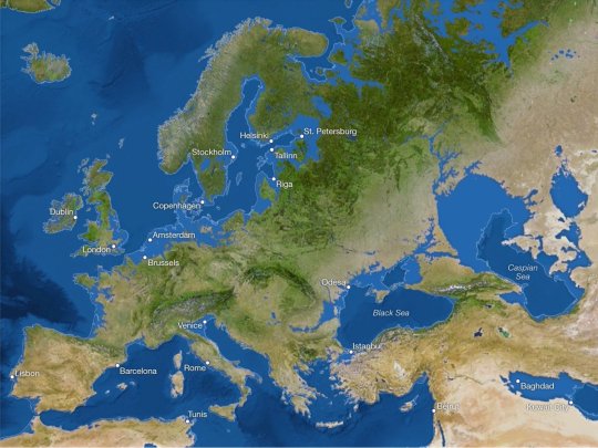
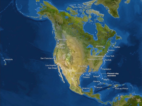

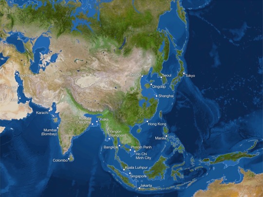
The September 2013 issue of National Geographic Magazine published these maps showing the world as it is now, but with all the ice on land melted and drained into the sea, raising it 216 feet and creating new shorelines for our continents and inland seas.
by NatGeoMaps
643 notes
·
View notes
Photo
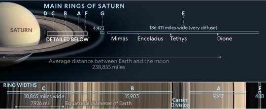
Scientists don’t agree on when the planet’s iconic rings formed—or even how they came to be. But the theories have one thing in common: violence.
Read the @NatGeoMag story at
https://www.nationalgeographic.com/science/article/saturn-rings-formation-theories?linkId=201994405
by @NatGeoMaps
68 notes
·
View notes
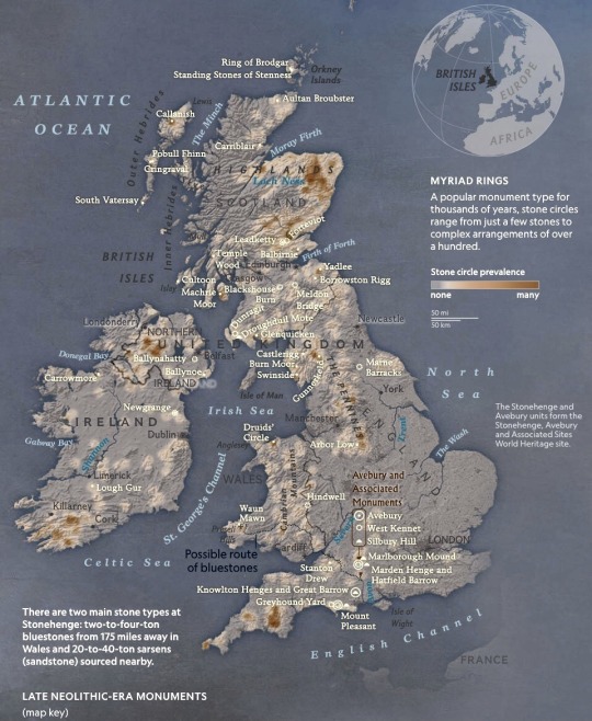
Text
Late neolithic-era monuments
by natgeomaps
Something momentous was in the air in the south of Britain about 4,500 years ago during the dying days of the Neolithic era, the final chapter of the Stone Age. Whatever it was—religious zeal, bravura, a sense of impending change—it cast a spell over the inhabitants and stirred them into a frenzy of monument building.In an astonishingly brief span of time—perhaps as little as a…
View On WordPress
1 note
·
View note
Text
Late neolithic-era monuments
by natgeomaps
Something momentous was in the air in the south of Britain about 4,500 years ago during the dying days of the Neolithic era, the final chapter of the Stone Age. Whatever it was—religious zeal, bravura, a sense of impending change—it cast a spell over the inhabitants and stirred them into a frenzy of monument building.In an astonishingly brief span of time—perhaps as little as a…

View On WordPress
0 notes
Photo
Sharing more of this awesome trip earlier this summer! Music by Benjamin Francis Leftwich @natgeotravel @natgeo @natgeoyourshot @lindbladexp @netgo_wild @natgeoadventure @creativenativeak @natgeomaps (at Glacier Bay, National Park-Alaska) https://www.instagram.com/p/CSC7oDvBO-S/?utm_medium=tumblr
0 notes
Text

[10 July 2021 🇬🇧🇮🇪] natgeomaps Published in June 1937, this illustrated map of the #BritishIsles designed by famed #NatGeo cartographer and #London native Charles E. Riddiford features colorful illustrations, county indexes, and thousands of places of interest in #England, #Wales, #Scotland, and #Ireland. The illustrated border contains sketches of historical figures and locations of interest including including cathedrals, ruins, battlefields, and more. The map was updated and republished in the April 1949 issue of the magazine. (https://www.instagram.com/p/CQv-GpnMI3e/?utm_medium=copy_link)
instagram
0 notes
Photo
RT @NatGeoMaps: Maps explain the 27 national monuments under review by Trump. https://t.co/E5JxAeyJ4B https://t.co/ihsn5YWpoC
5 notes
·
View notes
Text
0 notes
Link
Giving birth in the U.S. is surprisingly deadly https://t.co/ahonN2yz0C pic.twitter.com/MgcLVF3aaL
— NatGeoMaps (@NatGeoMaps) December 13, 2018
0 notes
Text
National Geographic Compiles a Digital Archive of 6,000 Editorial Maps From 1888 to Present Day
National Geographic Compiles a Digital Archive of 6,000 Editorial Maps From 1888 to Present Day

A post shared by NatGeoMaps (@natgeomaps) on Nov 13, 2017 at 2:15pm PST
National Geographic has compiled and digitally archived 6,000 of their iconic editorial maps from the time of their first issue in 1888 through present time. While the archive itself will not be available to the public, the magazine will be making different maps available through their social media accounts on Twitter,…
View On WordPress
0 notes
Photo


Long distance trails like the Appalachian Trail represent the ultimate manifestation of trail collaboration across local, state, and national scales
by @NatGeoMaps
659 notes
·
View notes
Text
Descubren un orangután 'nuevo' que surgió hace más de tres millones de años
Nuevo artículo publicado en https://www.prozesa.com/2017/11/14/descubren-un-orangutan-nuevo-que-surgio-hace-mas-de-tres-millones-de-anos/
Descubren un orangután 'nuevo' que surgió hace más de tres millones de años
Los 800 representantes de esta especie, que habitan en la isla indonesa Sumatra, son los grandes simios más raros del planeta.
Tras analizar los genomas de 37 monos procedentes de varias zonas del hábitat de estos animales, un grupo internacional de científicos ha confirmado la existencia de una nueva especie de orangután, según aparece recogido en un artículo, publicado este jueves en la revista 'Current Biology'. La especie, denominada Pongo tapanuliensis, habita únicamente un bosque situado a gran altura llamado Batang Toru, en el norte de Sumatra, Indonesia. Solo existen 800 ejemplares de este orangután, según los expertos. https://twitter.com/NatGeoMaps/status/926140654970949632 Hasta ahora los científicos solo distinguían dos especies de este gran mono: la de Sumatra (Pongo abelii) y la de la isla vecina de Borneo (Pongo pygmaeus). Sin embargo, un análisis genético y el estudio comparativo de los cráneos de los monos permitió concluir a los investigadores que se trata de una tercera rama que, supuestamente, quedó aislada de los antecesores de las otras dos especies hace unos 3,38 millones de años. Paradójicamente, la especie recién descubierta es la más antigua de las tres. Los rasgos que distinguen al Pongo tapanuliensis son el tamaño de su cráneo, ligeramente menor, y un pelo más rizado que le cubre más zonas del rostro.
Actualmente la ciencia distingue seis especies de grandes simisos antropoideos que forman parte de la familia de los homínidos: los orangutanes de Borneo y Sumatra, los gorilas occidental y beringei, el chimpancé y el bonobo.
Los orangutanes, que habitan únicamente en Indonesia, están bajo peligro de extinción.
0 notes
Photo

Roughly half of earth’s land has minimal human impact.
A compilation of four methods for mapping human impact reveals in detail where humanity’s influence on the natural world is considered to be low.
179 notes
·
View notes
Photo
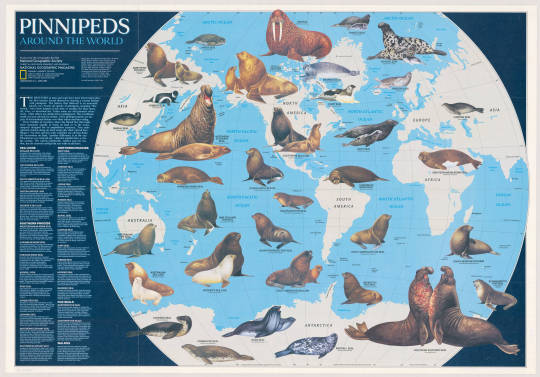
Pinnipeds Around the World, National Geographic, 1987.
186 notes
·
View notes
Photo
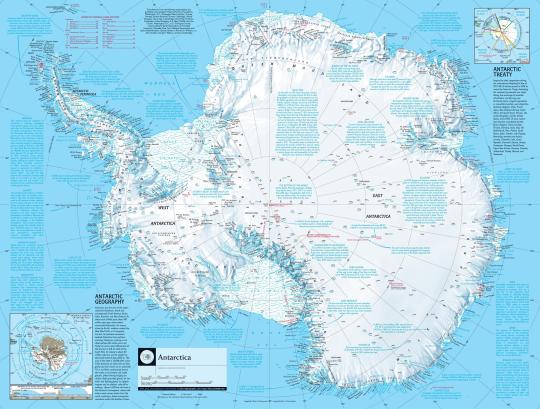
A detailed map of Antarctica.
by National Geographic
212 notes
·
View notes
Photo
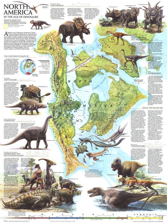
Published in January 1993, this illustrated map shows North America as it was 74 million years ago when Tyrannosaurs, Ceratopsians, and Sauropods roamed the region.
by NatGeoMaps
390 notes
·
View notes
Last Seen Blogs

dimmitri
🔮

abcdefghi7lmnopqrstuvwxyz
Ꮷ𝘦𝘤𝖺l̲𝖼𝗼𝗺𝘢𝗇𝙞𝙖.ﹻ


all-days-all-right
All days, all right

plantey
plantey