#PositioningSystems
Explore tagged Tumblr posts
Visit Tumblr Blog
Explore Tumblr blogs with no restrictions, modern design and the best experience.
Last Seen Tumblr Blogs


Fun Fact
Tumblr has a low social media market share in South America.
Text
Learn about GPS/GNSS antennas designed for accurate positioning and navigation in applications like vehicles, drones, and surveying equipment. Discover their role in enabling reliable global connectivity and precise tracking in modern technologies.
0 notes
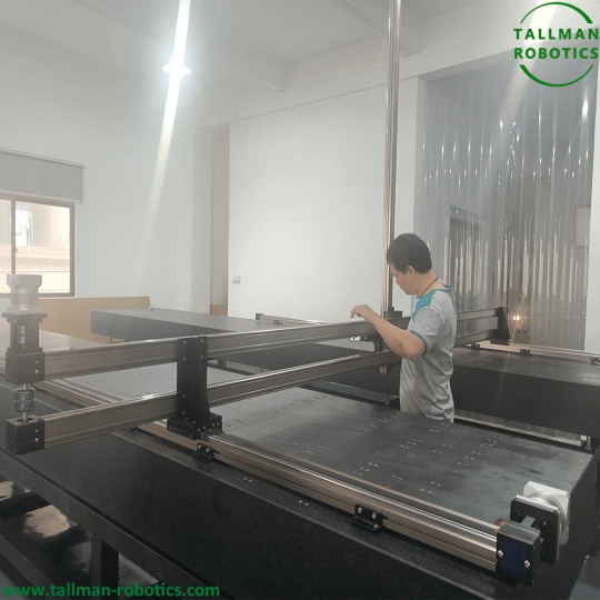
Text
Long Stroke Linear Gantry Robots are delivered to Italy

Long stroke Motorized XYZ Linear Stages by 4 meters are delivered to Italian Client. You are welcome to https://www.youtube.com/@tallmanrobotics to watch our video centre for more projects or visit our website load down e-catalogues for further technical data.


Motorized XYZ Linear Stages, XYZ three-axis linear motion platform is composed of three-axis linear modules, taking observation as the coordinate origin: the horizontal line realizing left and right linear motion is the X axis, the Y axis realizing front and rear linear motion, and Z axis realizing up and down linear motion. Z-axis is fixed on the X-axis linear module, and the Y-axis is fixed on the center of the platform; Z axis is called the operation axis or tool axis. In which industry the platform machine is used, what tools are installed on the Z axis; Y axis is the load axis, which carries the articles to be processed; X axis is positioned on the intersection point with the Y axis by moving left and right. What operations can XYZ three-axis linear motion platform(Motorized XYZ Linear Stages) achieve? Painting operation: painting operation is realized by three-axis movement fixed-point, and painting patterns and characters can be realized by accurate spraying in Y-axis point. Assembly: use the precise characteristics of the three-axis platform to assemble products, so as to reduce assembly time and improve production efficiency. Dispensing operation: precise dispensing and collecting operation is realized through three-axis fixed point. Soldering operation: similar to dispensing operation, it can be realized at fixed points. Screw locking operation: similar to glue dispensing operation, screw locking operation is realized at fixed points. Print job: use the sliding table to move at equal speed and distance to realize IC printing job. With the rapid development of automation, XYZ three-axis linear motion platform is more and more widely used. By installing or replacing tools in the Z-axis, and system programming, different application purposes can be achieved. Read the full article
#MiniatureStages#MotorizedMultiAxisStages#MotorizedxyzStage#Multi-AxisMotorized3-AxisStage#PositioningSystems#PrecisionLinearStage#PrecisionXYandXYZStages#XYZMotorizedTranslationStage#XYZPrecisionLinearStages#XYZ-Stages
0 notes
Text
Five Benefits of Asset Tracking and Indoor Navigation System

An indoor navigation system helps in locating assets such as the object, areas of interest, and people inside a facility by tapping indoor frequencies from radio waves, acoustic signals, magnetic fields, and other sensory information which can be transferred and collected easily using a Smartphone.
Referred to as an ‘Indoor GPS’, an indoor navigation system is a positioning and navigation technology which aids in locating assets within a large facility. An indoor navigation app combines various benefits like wayfinding, workforce collaboration, and asset tracking rolled into one holistic application.
Features of Indoor Navigational Technology
Accuracy An indoor navigation system can offer the highest accuracy in locating assets while helping the navigation of users within the facility.
Versatility The system supports multiple users on the application and continues to work offline as well.
No extensive hardware Indoor navigation technology needs minimum additional hardware as it can adapt well to existing networks. Only beacons may be added depending on the number of assets to be located. Users will use the app on their Smartphone anyway.
Emergency Management Through the navigation, platform messages could be sent to users to alert them on safety tips and emergency regulations.
#indoornavigation#indoorpositioningandnavigation#indoornavigationsystem#positioningsystems#indoorlocalization#indoorpositioningsystem
0 notes
Text
Free Map & Navigation vector glyph icons pack 6

15 Map & Navigation glyph icons pack icons pack free vector icons in SVG, PSD, EPS and AI format file available for commercial use. Read the full article
#Addressnavigator#Direction#distance#Earthplanet#findlocation#Geolocation#geomarketing#glyphicon#Gpsnavigation#Homeaddressfinder#homelocatio#Locationholder#Locationpins#locationsearch#map#mappin#positioningsystem#PSD
0 notes
Photo

A Crowd Sourcing to Track Individuals in Highly Active Industries
by R. Mahalakshmi | S. Janani | R. Sivasankari "A Crowd Sourcing to Track Individuals in Highly Active Industries"
Published in International Journal of Trend in Scientific Research and Development (ijtsrd), ISSN: 2456-6470, Volume-3 | Issue-3 , April 2019,
URL: https://www.ijtsrd.com/papers/ijtsrd22777.pdf
Paper URL: https://www.ijtsrd.com/computer-science/other/22777/a-crowd-sourcing-to-track-individuals-in-highly-active-industries/r-mahalakshmi
indexed journal, conference issue publication, high impact factor
This paper represents an idea to track employee in highly active industries using mobile application. The majority of geographic positioning systems had been designed to operate within environments that have a long term stable macro structure with potential small scale dynamics. These assumptions enable the present positioning systems to supply and utilize maps. In extremely active industrial settings these assumptions are not valid and so the task of tracking employees is very difficult because of large scale changes in structure. In this project, an unique positioning system for following individuals in highly active industries such as construction sites, marketing and so on. However our system uses cross modality coaching in order to track the environmental changes by utilizing occlusion maps and how these maps can be used in conjunction with social forces to predict human movement and increase the tracking accuracy.
0 notes
Video
Five Benefits of Asset Tracking and Indoor Navigation System by Raghava Kolanupaka Via Flickr: An indoor navigation system helps in locating assets such as the object, areas of interest, and people inside a facility by tapping indoor frequencies from radio waves, acoustic signals, magnetic fields, and other sensory information which can be transferred and collected easily using a Smartphone. Referred to as an ‘Indoor GPS’, an indoor navigation system is a positioning and navigation technology which aids in locating assets within a large facility. An indoor navigation app combines various benefits like wayfinding, workforce collaboration, and asset tracking rolled into one holistic application. Features of Indoor Navigational Technology Accuracy An indoor navigation system can offer the highest accuracy in locating assets while helping the navigation of users within the facility. Versatility The system supports multiple users on the application and continues to work offline as well. No extensive hardware Indoor navigation technology needs minimum additional hardware as it can adapt well to existing networks. Only beacons may be added depending on the number of assets to be located. Users will use the app on their Smartphone anyway. Emergency Management Through the navigation platform messages could be sent to users to alert them on safety tips and emergency regulations. Explore pigeon.srisys.com/
#indoornavigationsystem#indoornavigation#indoorlocalization#positioningsystems#indoorpositioningandnavigation#indoorpositioning
0 notes
Link
#fleetprivatenetwork#inc#joplin#lovetravelstops#pilottravelcenters#positioningsystem#truckstopsdirect#unitedstates
0 notes
Text
Download Solution manual for Elementary Surveying An Introduction to Geomatics 14th Edition
Solution manual for Elementary Surveying 14th Edition by Charles D. Ghilani, Paul R. Wolf
Solution manual for Elementary Surveying An Introduction to Geomatics 14th Edition
This is completed downloadable link for Elementary Surveying An Introduction to Geomatics 14th Edition Solution manual
Click here to download sample of Elementary Surveying An Introduction to Geomatics 14th Edition Solution manual
The full solutions manual, answers for chapter list:
1 – Introduction 1 2 – Units, Significant Figures,and Field Notes 22 3 – Theory of Errors in Observations 45 4 – Leveling-Theory, Methods,and Equipment 71 5 – Leveling-Field Procedures and Computations 100 6 – Distance Measurement 124 7 – Angles, Azimuths, and Bearings 162 8 – Total Station Instruments: Angle Measurements 182 9 – Traversing 222 10 – Traverse Computations 235 11 – Coordinate Geometry inSurveying Calculations 265 12 – Area 296 13 – The Global Positioning System-Introduction and Principlesof Operation 318 14 – The Global PositioningSystem-Static surveys 354 15 – The Global PositioningSystem-Kinematic GPS 385 16 – Adjustments by Least Squares 404 17 – Mapping Surveys 450 18 – Mapping 488 19 – Control Surveys and GeodeticReductions 514 20 – State Plane Coordinates 571 21 – Boundary Surveys 612 22 – Surveys of the Public Lands 638 23 – Construction Surveys 663 24 – Horizontal Curves 693 25 – Vertical Curves 734 26 – Volumes 753 27 – Photogrammetry 773 28 – Introduction to Geographic Information Systems 818
Some informations about original book:
ISBN-13: 000-0133758885
ISBN-10: 0133758885
Link download full: https://getbooksolutions.com/download/solution-manual-for-elementary-surveying-14th-edition/
Elementary Surveying, Fourteenth Edition, is ideal for Surveying courses offered in Civil Engineering departments and is a useful reference for civil engineers.
This highly readable, best-selling text presents basic concepts and practical material in each of the areas fundamental to modern surveying (geomatics) practice. Its depth and breadth are ideal for self-study. Elementary Surveying, Fourteenth Edition, is updated throughout to reflect the latest advances and technology.
#elementary#surveying#Ghilani#Elementary Surveying An Introduction to Geomatics#Elementary Surveying An Introduction to Geomatics 14th Edition
0 notes
Text
Map & Navigation vector circle glyph icons pack 6

15 Map & Navigation circle glyph icons pack icons pack free vector icons in SVG, PSD, EPS and AI format file available for commercial use. Read the full article
#Addressnavigator#circleicon#Direction#distance#Earthplanet#findlocation#Geolocation#geomarketing#Gpsnavigation#Homeaddressfinder#homelocatio#Locationholder#Locationpins#locationsearch#map#mappin#positioningsystem#PSDDescriptionReviews(0)VendorInfoMoreProducts
0 notes
Text
Map & Navigation vector line icons pack 6

15 Map & Navigation line icons pack icons pack free vector icons in SVG, PSD, EPS and AI format file available for commercial use. Read the full article
#Addressnavigator#Direction#distance#Earthplanet#findlocation#Geolocation#geomarketing#Gpsnavigation#Homeaddressfinder#homelocatio#lineicon#Locationholder#Locationpins#locationsearch#map#mappin#positioningsystem#PSD
0 notes
Video
youtube
What is Position and GPS? Career in Offshore Survey
#PositioningSystem #GPS #CareerGuide #OffshoreSurveying Click to Subscribe https://www.youtube.com/c/AmazingIndian?sub_confirmation=1
0 notes