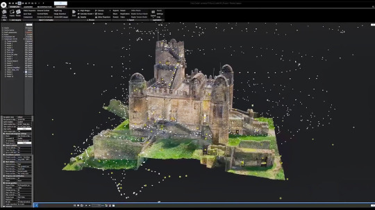
#RealityCapture
Explore tagged Tumblr posts
Visit Tumblr Blog
Explore Tumblr blogs with no restrictions, modern design and the best experience.
Last Seen Tumblr Blogs


Fun Fact
Tumblr is available in 18 languages.
Text
RealityCapture 1.5: La Fotogrammetria Rivoluzionata
La fotogrammetria è una tecnica che consente di ricostruire modelli tridimensionali di oggetti o ambienti reali a partire da fotografie o scansioni laser. Questa metodologia, utilizzata in settori come l’architettura, l’archeologia, la geologia e persino il cinema, si basa sull’analisi delle immagini per estrarre informazioni metriche e geometriche. Con l’avvento di software avanzati come…
#ArchitetturaDigitale#ArteDigitale#CreazioneContenuti#DesignDigitale#DigitalTransformation#EffettiVisivi#Fotogrammetria3D#GameDesign#InnovazioneTecnologica#Modellazione3D#ProduzioneVirtuale#RealityCapture#RealityCapture1_5#Scansioni3D#TecnologiaDigitale
0 notes
Text
Top Benefits of 3D Laser Scanning Services for Accurate As-Built Documentation & Reality Capture

Tejjy Inc. is a trusted 3D laser scanning company in the USA, offering high-resolution reality capture and accurate as-built data for various industries. Our skilled professionals deliver precise 3D scanning services, providing point cloud data, 3D models, CAD drawings, and digital twins. With an accuracy of 4-6 mm, we cater to diverse sectors, including renovation, surveying, facility management, and heritage preservation. Serving over 150 million square feet, our solutions support general contractors, architects, engineers, asset managers, and more. Whether you need building scanning, lidar services, or 3D scanning, Tejjy Inc. is your go-to for accurate, reliable results.
#3DLaserScanning#LaserScanning#ScanToBIM#3DScanning#RealityCapture#PointCloud#DigitalTwin#Surveying#Architecture#USA
0 notes
Text
A snapshot of Scan to BIM and best practices.
Scan to BIM (Building Information Modeling) is a process of converting physical or 3D laser scan data of a building or structure into a detailed, digital 3D model. The process involves capturing the geometry and features of a structure using 3D laser scanning technology and then processing the data to create a detailed 3D model. The resulting BIM model can be used for a variety of purposes, such as design, renovation, and facility management.

Capture the physical structure.
The first step in the scan to BIM process is to capture the physical structure using 3D laser scanning technology. This involves using a laser scanner to capture millions of data points about the shape, size, and location of the building or structure. The laser scanner emits a laser beam that bounces off the surfaces of the building and returns to the scanner, where it is measured and recorded. The resulting data is known as a "point cloud”.
Processing Point Cloud data to generate a 3D model.
The point cloud data is then processed using specialized software to create a 3D model. The software uses algorithms to analyze the point cloud data and identify features such as walls, floors, ceilings, windows, doors, and other structural elements. The software can also remove noise and errors from the data to create a more accurate representation of the building.
Import the data into Revit.
Once the 3D model has been created, it can be imported into BIM software such as Autodesk Revit. BIM software allows designers, architects, and engineers to create detailed models of the building that include information about the structure, materials, and systems such as HVAC, electrical, and plumbing. BIM models can also include information about the building's energy consumption, carbon footprint, and other sustainability metrics.
Level of detail and Level of accuracy.
One of the main benefits of using scan to BIM is the level of detail and accuracy that can be achieved. Laser scanning technology can capture millions of data points, resulting in a highly accurate representation of the building. This can be especially useful for renovation or retrofit projects, where accurate measurements are critical for ensuring that new elements fit properly with the existing structure.
Safety on construction sites.
Scan to BIM can also be used to improve safety on construction sites. By creating a detailed digital model of the building, construction workers can visualize the building in 3D and identify potential hazards or safety issues before they arise. This can help prevent accidents and injuries on the job site.
Reduce costs and project timelines.
Another benefit of the scan to BIM is that it can help reduce project timelines and costs. By using laser scanning technology to capture the building's geometry, designers and engineers can avoid the need for manual measurements and reduce the time required to create accurate models. This can result in cost savings for the project as well as reduced construction timelines.
Best practices of Scan to BIM.
This process has become increasingly popular in the construction industry due to its ability to provide highly accurate and detailed information about existing structures. Here are some best practices for Scan to BIM:
1. Plan the project thoroughly: Before starting the scanning process, it's important to plan out the project. This includes determining the scope of the project, identifying any potential obstacles or challenges, and creating a timeline.
2. Use high-quality equipment: To ensure the accuracy of the data collected during the scanning process, it's important to use high-quality equipment. This includes 3D laser scanners, cameras, and other related equipment.
3. Capture all relevant data: When scanning the building, it's important to capture all relevant data, including walls, floors, ceilings, and other structural elements. This will help create a more accurate and detailed 3D model.
4. Use a consistent scanning methodology: To ensure consistency in the data collected, it's important to use a consistent scanning methodology. This includes using the same scanning settings, capturing data in the same order, and scanning at the same speed.
5. Verify and validate the data: After the scanning process is complete, it's important to verify and validate the data. This includes comparing the scan data to existing building plans or other reference materials to ensure accuracy.
6. Use experienced professionals: To ensure the success of the Scan to BIM project, it's important to use experienced professionals who are familiar with the scanning process and the software used to create the 3D model.
7. Collaborate with stakeholders: Throughout the Scan to BIM process, it's important to collaborate with all stakeholders, including architects, engineers, and contractors. This will ensure that the final 3D model meets everyone's needs and expectations.
How can BIM Engineering US, L.L.C. support modern construction, renovation, and facilities management with Scan to BIM?
BIM Engineering US, L.L.C. can support modern construction, renovation, and facilities management with Scan to BIM by leveraging the power of 3D scanning technology and Building Information Modeling (BIM).
Scan to BIM is a process of capturing the physical environment of a building using 3D laser scanners and converting it into a digital model that can be used for design, construction, renovation, and facilities management. This digital model, created by BIM Engineering US, L.L.C., can be used to improve the accuracy, efficiency, and quality of the construction and renovation process while reducing costs and minimizing errors.
Here are some of how BIM Engineering US, L.L.C. can support modern construction, renovation, and facilities management with Scan to BIM:
1. Accurate documentation of existing conditions: Scan to BIM allows BIM Engineering US, L.L.C. to capture accurate measurements and data of the existing building conditions, such as dimensions, shapes, and layouts. This information can be used to create a highly accurate 3D model of the building that can be used for planning and design purposes
2. Streamlined design process: BIM Engineering US, L.L.C. can use the Scan to BIM model to streamline the design process by importing the scanned data into their BIM software, allowing them to create accurate and detailed designs based on the existing conditions of the building
3. Improved construction planning and coordination: With the Scan to BIM model, BIM Engineering US, L.L.C. can perform clash detection and constructability analysis to identify potential conflicts and issues before construction begins. This helps to reduce delays, change orders, and costs during the construction process
4. Efficient renovation and retrofitting: Scan to BIM can also be used for renovation and retrofitting projects by creating an accurate 3D model of the existing building, which can be used to plan and execute the renovation process. This can reduce the time and cost of the renovation process, and minimize disruption to building occupants
5. Improved facilities management: BIM Engineering US, L.L.C. can also use the Scan to BIM model to improve facilities management by creating a detailed record of the building's systems and components, including HVAC, plumbing, and electrical systems. This can be used to track maintenance and repairs and plan for future upgrades or replacements
Improving the accuracy and speed of existing conditions with Reality Capture.
Reality Capture is a powerful tool for improving the accuracy and speed of existing conditions documentation. Here are some ways that you can use Reality Capture to achieve these goals:
1. Accurately capture existing conditions: Reality Capture allows you to create accurate 3D models of existing conditions using photogrammetry, laser scanning, or a combination of both. This can help you ensure that your documentation is accurate and up-to-date, and can save you time by eliminating the need for manual measurements.
2. Quickly process data: Reality Capture is designed to process large amounts of data quickly, which means you can create accurate 3D models in a fraction of the time it would take to create them manually. This can save you time and allow you to focus on other aspects of your project
3. Improve communication: 3D models created with Reality Capture can be easily shared with team members, clients, and stakeholders. This can help improve communication and ensure that everyone is on the same page.
4. Enhance design workflows: Reality Capture can be used to create accurate 3D models that can be imported into other software applications, such as CAD or BIM software. This can enhance your design workflows and help you create more accurate and efficient designs.
5. Detect changes: Reality Capture can be used to detect changes in existing conditions over time. By comparing 3D models created at different points in time, you can identify changes that may affect your project and make necessary adjustments.
In summary,
Scan to BIM is a process of converting physical or 3D laser scan data of a building or structure into a detailed, digital 3D model. The process involves capturing the geometry and features of a structure using 3D laser scanning technology and then processing the data to create a detailed 3D model. The resulting BIM model can be used for a variety of purposes, such as design, renovation, and facility management. Scan to BIM offers a range of benefits, including improved accuracy, safety, and cost savings.
Reality Capture is a powerful tool that can help you improve the accuracy and speed of existing conditions documentation. By using this technology, you can create accurate 3D models quickly and easily, improve communication with stakeholders, enhance your design workflows, and detect changes in existing conditions.
BIM Engineering US, L.L.C. can support modern construction, renovation, and facilities management with Scan to BIM by providing accurate documentation of existing conditions, streamlined design processes, improved construction planning and coordination, efficient renovation and retrofitting, and improved facilities management.
Call Us: +1-703-994-4242
Visit Us: www.bimengus.com
0 notes
Text
「RealityCapture 1.4」更新推出:免費授權模式及Epic Games整合介紹
隨著科技的進步,RealityCapture 1.4 版本在 Epic Games 啟動器中的推出,不僅優化了其價格模型,還為使用者帶來了更便捷的服務。RealityCapture 是一款廣受讚譽的三維掃描軟件,常用於數位保存和虛擬實境創建中。 從今日起,RealityCapture 將針對學生、教育工作者、業餘愛好者以及年收入不超過100萬美元的公司免費提供。此外,年收入超過此門檻的公司可透過訂閱方式,每位用戶每年支付1,250美元來使用這款軟件。另一方面,RealityCapture 也包含在 Unreal 訂閱套餐中,該套餐還包括 Unreal Engine 和 Twinmotion,其訂閱費用為每位用戶每年1,850美元。 Epic Games 啟動器中的 RealityCapture 1.4 版本,支持直接下載、安裝及更新,為用戶提供了更為便捷的操作體驗。此外,Epic…

View On WordPress
0 notes
Text
OpticVyu ONE
𝗢𝗽𝘁𝗶𝗰𝗩𝘆𝘂 𝗢𝗻𝗲: A unified platform for entire construction lifecycle monitoring
📸 Time-lapse Cameras for real-time progress tracking 🏢 360° Interior Monitoring to capture every corner 🚁 Drone Surveillance for aerial site overviews 🌐 Immersive 360° Virtual Tours for remote walkthroughs 📊 Scan-to-BIM for accurate digital modeling 🛰️ LiDAR Scanning for precision analysis 📦 Material Tracking to keep inventory under control
OpticVyuOne #ConstructionInnovation #RealityCapture #DigitalConstruction #SmartBuilding #ConstructionMonitoring
1 note
·
View note
Text
Daftar Aplikasi Pemetaan pada Drone Aerial


Aplikasi Pemetaan Drone Aerial Terbaik untuk Setiap Sistem Operasi
Well! Drone aerial telah menjadi alat yang sangat berguna dalam berbagai industri, mulai dari survei lahan hingga inspeksi infrastruktur. Salah satu keunggulan utama drone adalah kemampuannya untuk mengumpulkan data spasial yang sangat detail dalam waktu yang singkat. Untuk mengolah dan menganalisis data tersebut, diperlukan aplikasi pemetaan yang tepat. Postingan ini akan membahas tentang Aplikasi Pemetaan Drone Aerial Terbaik untuk Setiap Sistem Operasi, Mulai dari iOS, MacOS, Windows, dan Android. Simak terus ulasan kami berikut ini!
Dan berikut adalah daftar aplikasi pemetaan drone aerial terbaik untuk setiap sistem operasi populer:
Aplikasi Drone Aerial Mapping di OS iOS
1. DroneDeploy: Aplikasi ini sangat populer di kalangan pengguna drone karena antarmuka yang user-friendly dan fitur-fitur canggih seperti perencanaan penerbangan otomatis, pemrosesan gambar real-time, dan analisis data yang mendalam.
2. Pix4Dcapture: Dikenal dengan akurasi dan keandalannya, Pix4Dcapture memungkinkan pengguna untuk menangkap data berkualitas tinggi dan menghasilkan model 3D yang sangat detail.
3. Litchi: Aplikasi ini menawarkan kontrol penerbangan yang presisi dan fitur-fitur canggih seperti penghindaran rintangan otomatis dan perencanaan misi yang kompleks.
4. AirData: Selain sebagai aplikasi kontrol penerbangan, AirData juga menyediakan platform untuk mengelola dan menganalisis data penerbangan.
5. DJI Pilot: Aplikasi resmi dari DJI, produsen drone terkemuka, menawarkan integrasi yang seamless dengan drone DJI dan fitur-fitur khusus seperti Live Map dan Smart Follow.
Aplikasi Drone Aerial Mapping di OS macOS
1. Agisoft Metashape: Software ini sangat populer di kalangan profesional karena kemampuannya untuk menghasilkan model 3D yang sangat akurat dan rinci dari foto udara.
2. Pix4Dmapper: Mirip dengan Pix4Dcapture, Pix4Dmapper adalah software desktop yang kuat untuk memproses data drone dan menghasilkan peta orto, model 3D, dan analisis lainnya.
3. DroneDeploy: Versi desktop dari DroneDeploy menawarkan fitur-fitur yang sama dengan versi mobile-nya, tetapi dengan kemampuan pemrosesan yang lebih tinggi.
4, MapPilot: Aplikasi ini dirancang khusus untuk pemetaan pertanian dan menawarkan fitur-fitur seperti analisis vegetasi dan perhitungan volume.
5. ContextCapture: Software dari Bentley Systems ini sangat cocok untuk proyek-proyek infrastruktur dan menawarkan fitur-fitur seperti pemodelan realitas 3D dan analisis visual.
Aplikasi Drone Aerial Mapping di OS Windows
1. Agisoft Metashape: Versi Windows dari Agisoft Metashape menawarkan fitur-fitur yang sama dengan versi macOS.
2. Pix4Dmapper: Versi Windows dari Pix4Dmapper juga tersedia dan menawarkan kinerja yang sangat baik.
3. DroneDeploy: Versi Windows dari DroneDeploy sangat cocok untuk pengguna yang ingin mengolah data drone di komputer desktop mereka.
4. MapPilot: Versi Windows dari MapPilot juga tersedia dan menawarkan fitur-fitur yang sama dengan versi macOS.
5. RealityCapture: Software dari Capturing Reality ini sangat populer untuk menghasilkan model 3D yang sangat detail dari data drone.
Aplikasi Drone Aerial Mapping di OS Android
1. DroneDeploy: Versi Android dari DroneDeploy sangat populer karena kemudahan penggunaannya dan fitur-fitur yang lengkap.
2. Litchi: Versi Android dari Litchi menawarkan kontrol penerbangan yang presisi dan fitur-fitur canggih.
3. DJI Pilot: Versi Android dari DJI Pilot sangat cocok untuk pengguna drone DJI.
4. AirData: Versi Android dari AirData memungkinkan pengguna untuk mengelola dan menganalisis data penerbangan di lapangan.
5. Autel Explorer: Aplikasi resmi dari Autel Robotics, produsen drone lain, menawarkan integrasi yang seamless dengan drone Autel.
Kesimpulan
Pilihan aplikasi pemetaan drone aerial sangat beragam dan terus berkembang. Pemilihan aplikasi yang tepat akan sangat bergantung pada jenis drone yang digunakan, jenis data yang ingin dikumpulkan, dan tujuan akhir dari proyek pemetaan. Dengan adanya aplikasi-aplikasi ini, pengolahan dan analisis data drone menjadi lebih mudah dan efisien. See you!
Source: https://www.jasadronesurabaya.com
Catatan: Daftar aplikasi di atas hanya sebagian kecil dari aplikasi pemetaan drone aerial yang tersedia. Sebaiknya anda melakukan riset lebih lanjut untuk menemukan aplikasi yang paling sesuai dengan kebutuhan anda.
0 notes
Text
Breaking Boundaries: Exploring Recent Innovations by 3D Environment Artists
Introduction:
In the world of making games and 3D worlds, artists are always trying new things to make games better. Lately, 3D artists have been doing some cool stuff that's changing how digital art and storytelling in games work. I'm going to talk about some of the best new ideas and the artists who are making them happen.
The Emergence of Photogrammetry:
A big thing happening now in making 3D worlds is using photogrammetry. This cool technique takes pictures of real things and turns them into super realistic 3D models for games. Artists like William Faucher (Author at Epic/Unreal Online Learning) and Quixel Megascans (Megascans is the world's largest 3D asset scan library) are good at using photogrammetry to make amazing places in games that look almost real. They show how this technique can make digital worlds look like the real world, with lots of detail and authenticity.

Procedural Generation Techniques:
Another cool thing happening in making 3D worlds is procedural generation. This means using special tools and computer programs to make big and different landscapes, cities, and natural areas without needing to do a lot of work by hand. Hello Games made a project called No Man's Sky that shows how powerful procedural generation can be. With this technique, artists can make really big and interesting worlds for players to explore without having to make everything by hand.

Real-Time Rendering Engines:
More and more artists are using real-time rendering engines like Unreal Engine and Unity to make 3D worlds. These engines let artists work fast and see their creations right away, which makes it easy to try out new ideas. Entertainment companies like Skydance Media (Marvel 1943: Rise of Hydra) are using real-time rendering to make games and experiences that people like. With these engines, artists can make amazing-looking worlds and exciting places for players to explore.


Looking to the Future:
As artists keep trying new things in making 3D worlds, we'll see even more amazing stuff that changes how we think about digital art and games. Whether it's making things look super real, creating big worlds with special tools, or making games that feel like they're happening right now, artists are making things better and more exciting. As players, we can expect to play in cool worlds that make us feel like we're there, thanks to the awesome work of these artists.
Reference list
GameSpot. (n.d.). Marvel 1943: Rise of Hydra Release Date Window, Gameplay, and Everything We Know so Far. [online] Available at: https://www.gamespot.com/articles/marvel-1943-rise-of-hydra-release-date-trailer-news/1100-6522227/.
www.youtube.com. (n.d.). Capturing the World’s OLDEST Stave Church in Unreal Engine 5. [online] Available at: https://youtu.be/B5hBBFM2I_w?si=ZCFjPIqns7FfzcfD.
www.youtube.com. (n.d.). Marvel 1943: Rise of Hydra | Story Trailer. [online] Available at: https://youtu.be/Lb2wwEx6DVw?si=o9vrrGD-ZhS5xijD.
www.youtube.com. (n.d.). RealityCapture to UE5 - Workflow Tutorial. [online] Available at: https://youtu.be/WrCOhes1Zgg?si=Sx20q8v3NCaQUqHs.
0 notes
Text
Industry practices Blog 6:
Epic Games' Unreal Engine Pricing Changes: A Balanced Approach
As a creator in my last semester before graduating, I was intrigued to learn about Epic Games' updated pricing model for Unreal Engine, Twinmotion, and RealityCapture. The changes, set to take effect with Unreal Engine 5.4 in late April, aim to maintain free access for indie creators while introducing a subscription for larger non-gaming companies.
The key takeaways for creators like myself are:
Indie creators, students, educators, and hobbyists will continue to have free access to these tools if their annual gross revenue or per-title earnings remain below $1 million.
The new seat-based Unreal Subscription, priced at $1,850 per seat per year, will only impact non-game creators in industries like filmmaking, TV production, architectural visualisation, and those integrating Unreal Engine code at runtime, with yearly revenues exceeding $1 million.
Twinmotion and RealityCapture will also be free for students and hobbyists whose projects earn less than $1 million annually, while individual subscriptions will be available for purchase.
As a soon-to-be graduate exploring various creative avenues, this pricing update is reassuring. It preserves the accessibility of powerful tools like Unreal Engine, allowing me to continue experimenting and building my skills without financial barriers. The $1 million revenue threshold provides ample runway for indie creators to grow their businesses before needing to consider the subscription model.
For those interested in learning more about the implications of these changes for non-student creators, here are some additional perspectives:
The Venturebeat article notes that the new pricing model "aims to accommodate the evolving needs of developers and companies, introducing a new seat-based Unreal Subscription model for non-game industries." This suggests that the changes are designed to support a wider range of creators, not just those in the gaming industry.
The GameIndustry.biz article emphasizes that "Unreal Engine, Twinmotion, and RealityCapture will continue to be free to use for students, educators, and hobbyists, in addition to developers who earn less than $1 million in revenue." This is particularly relevant for creators like myself who are transitioning from student to professional status.
The Famiboards discussion thread highlights the potential for non-gaming companies to use Unreal Engine as an alternative to other commercial tools, like Autodesk's suite. This suggests that the pricing changes could open up new opportunities for creators in various industries to leverage Unreal Engine's capabilities.
In summary, Epic Games' Unreal Engine pricing changes maintain a balanced approach that supports indie creators while generating revenue from larger non-gaming companies. For non-student creators like myself, these updates preserve the accessibility of powerful tools, allowing us to continue exploring and developing our skills as we transition into the professional world.
References:
McEvoy, S. (2024, March 13). Epic confirms Unreal Engine price change for non-game developers. GamesIndustry.biz. https://www.gamesindustry.biz/epic-confirms-unreal-engine-price-change-for-non-game-developers
Sagadego. (2023, October 7). Epic Games to update Unreal Engine pricing for devs outside game industry; Epic Games began running into. . . [Online forum post]. Famiboards. https://famiboards.com/threads/epic-games-to-update-unreal-engine-pricing-for-devs-outside-game-industry-epic-games-began-running-into-financial-problems-about-10-weeks-ago.7726/
Takahashi, D. (2024, March 12). Epic Games updates prices for non-game Unreal Engine projects. VentureBeat. https://venturebeat.com/gaming-business/epic-games-updates-prices-for-non-game-unreal-engine-projects/
0 notes
Text
Updating Unreal Engine Pricing in Late April
https://www.unrealengine.com/en-US/blog/we-are-updating-unreal-engine-twinmotion-and-realitycapture-pricing-in-late-april
0 notes
Text
📸✨ Just transformed a RustyPump into a 3D model with a simple setup: a few dozen shots taken with a mid-range Nikon camera. Then, brought it to life using RealityCapture and #Houdini, and rendered in MarmoseToolbag.
0 notes
Text
https://www.youtube.com/watch?v=JgPEw__wbOI&feature=shared&fbclid=IwAR2a8GlA1RiGC4h5F8Oky4swXX-dXT85KnZbRDMLFOs6MlJjEFDV2Gxefz8
https://www.youtube.com/watch?v=JgPEw__wbOI&feature=shared&fbclid=IwAR2a8GlA1RiGC4h5F8Oky4swXX-dXT85KnZbRDMLFOs6MlJjEFDV2Gxefz8 #truthbetold#evidence#proof#uncensored#realworldevidence#womenrights#womenempowerment#abuseawareness#realitycapture
0 notes
Text
3D Reconstruction Software Market Size, Type, segmentation, growth and forecast 2023-2030
3D Reconstruction Software Market
The 3D Reconstruction Software Market is expected to grow from USD 12478.00 Million in 2022 to USD 21492.11 Million by 2030, at a CAGR of 9.03% during the forecast period.
Get the Sample Report:https://www.reportprime.com/enquiry/sample-report/11118
3D Reconstruction Software Market Size
3D Reconstruction Software is a type of software used to create 3D models and virtual representations of real-world objects or scenes. This market research report covers the market segment based on type, which includes 3D Reconstruction Software based on images and video, as well as based on 3D scanning. It also includes the application areas such as Culture Heritage and Museum, Films & Games, 3D Printing, Drones and Robots and Others. The report provides regional analysis of the market in North America, Asia Pacific, Middle East, Africa, Australia, and Europe. The market players covered in the report are Pix4D, Agisoft PhotoScan, Autodesk, RealityCapture, Acute3D, PhotoModeler, Photometrix, Elcovision, Vi3Dim Technologies, Paracosm, Matterport, Realsense (Intel), Mensi, Skyline Software Systems, Airbus, 4Dage Technology, Blackboxcv, and Shenzhen Zhineng Shixian Technology. Furthermore, the report also provides information on the regulatory and legal factors specific to market conditions.
3D Reconstruction Software Market Key Player
Pix4D
Agisoft PhotoScan
Autodesk
RealityCapture
Acute3D
Buy Now & Get Exclusive Discount on this:https://www.reportprime.com/enquiry/request-discount/11118
3D Reconstruction Software Market Segment Analysis
The 3D Reconstruction Software market is a rapidly growing market with a wide range of applications, including healthcare, entertainment, gaming, and architecture, among others. The software enables users to transform 2D images into 3D models, providing a detailed view of real-world objects, buildings, and environments.
The major factors driving revenue growth include the increasing demand for 3D printing technology, the growing adoption of 3D imaging in healthcare, and the rising use of 3D modeling in architectural and construction industries. Additionally, technological advancements such as the introduction of cloud computing and artificial intelligence are also driving revenue growth in this market.
The latest trends being followed in the 3D Reconstruction Software market include the increasing demand for mobile-based applications, the use of drones for data capture, and the integration of 3D scanning with photogrammetry for enhanced accuracy. Moreover, the trend towards software as a service and the increasing emphasis on user-friendly interfaces are also shaping the market.
However, the 3D Reconstruction Software market also faces several challenges, including the lack of standardization in 3D scanning and modeling processes, limited availability of skilled professionals, and the high cost of advanced software and hardware required for 3D reconstruction.
The report's main findings suggest that the 3D Reconstruction Software market is an attractive investment opportunity, with significant growth potential. It recommends that market players focus on developing user-friendly and cost-effective solutions, investing in R&D to remain competitive, and expanding their product offerings and geographic presence.
In conclusion, the 3D Reconstruction Software market is a dynamic and rapidly growing market with a wide range of applications. The market is driven by factors such as technological advancements, demand for 3D printing, and increasing adoption of 3D imaging in healthcare and other industries. However, the market also faces several challenges, including the lack of standardization and high costs.
This report covers impact on COVID-19 and Russia-Ukraine wars in detail.
Purchase This Report:https://www.reportprime.com/checkout?id=11118&price=3590
Market Segmentation (by Application):
Culture Heritage and Museum
Films & Games
3D Printing, Drones and Robots
Others
Information is sourced from www.reportprime.com
0 notes
Text
🏗️ 6 Benefits of LiDAR in Construction From millimeter precision to safer site surveys, LiDAR is transforming the way we build. Build smarter. Scan faster. Reduce rework.
LiDAR #ConstructionTech #AEC #DigitalTwin #RealityCapture #Matterport
1 note
·
View note
Text
How to Use Photogrammetry for Realistic 3D Game Assets
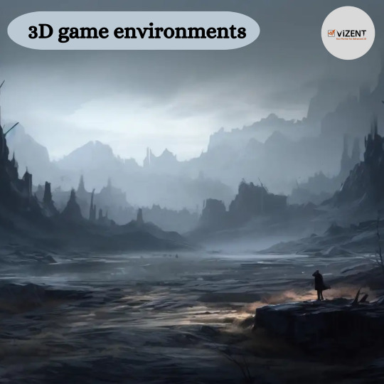
The gaming industry is constantly striving for realism, immersing players in lifelike 3D game environments that enhance the overall experience. One of the most groundbreaking technologies contributing to this realism is photogrammetry. This technique involves capturing real-world objects and environments and transforming them into highly detailed 3D models, making it a game-changer for 3D modeling games and asset creation.
In this blog, we’ll delve into how photogrammetry is revolutionizing the creation of game assets, its benefits for developers, and how it helps craft immersive 3D game environments.
What is Photogrammetry?
Photogrammetry is the process of using photographs to create accurate 3D models. By capturing multiple images of an object or environment from different angles, specialized software reconstructs these photographs into a 3D mesh complete with realistic textures. This approach is particularly beneficial for developing high-quality game assets like rocks, trees, buildings, or even entire landscapes.
Unlike traditional 3D modeling techniques, photogrammetry significantly reduces the time and effort required to create realistic objects. It also ensures unparalleled levels of detail and authenticity, which are critical for creating immersive 3D modeling games.
How to Use Photogrammetry for Game Asset Creation
Photogrammetry can seem like a complex process, but it’s relatively straightforward with the right tools and techniques. Here’s how you can use photogrammetry to create realistic 3D game assets:
1. Planning and Preparation
Before diving into photogrammetry, it’s essential to plan your project:
Identify the Game Asset: Determine what you need to capture. It could be a single object, such as a tree or a chair, or an entire 3D game environment like a forest or an urban setting.
Choose the Right Equipment: Use a high-resolution camera or even a smartphone with a quality camera. A tripod can help ensure consistent shots. Drones are great for capturing large-scale environments.
Lighting Conditions: Capture images in even lighting to minimize harsh shadows and overexposed areas. Overcast days are ideal for outdoor photography.
2. Capturing the Subject
Take Multiple Photos: Capture the subject from all possible angles to ensure a complete 3D reconstruction. Overlap between images (at least 60-70%) is crucial for accurate stitching.
Focus on Details: For intricate game assets, take close-up shots to capture fine details like cracks, textures, and unique features.
Maintain Consistency: Ensure the camera settings, such as focus, exposure, and white balance, remain consistent across all shots.
3. Processing Images into 3D Models
Once you’ve captured the images, use photogrammetry software to convert them into a 3D model. Popular tools include:
RealityCapture
Agisoft Metashape
The software will analyze the photos and create a detailed 3D mesh with textures applied directly from the images. Depending on the complexity of the game assets, this process might take anywhere from a few minutes to several hours.
4. Optimizing the 3D Models
While photogrammetry produces highly detailed models, they are often too resource-intensive for real-time rendering in games. Optimization ensures your assets maintain visual fidelity without compromising performance:
Retopology: Simplify the geometry of the 3D mesh while retaining its shape. Tools like Blender or Maya are commonly used for this step.
Texture Baking: Bake high-resolution textures onto a lower-polygon version of the model to maintain detail while reducing computational load.
LOD (Level of Detail) Creation: Create multiple versions of the asset with varying levels of detail for efficient rendering at different distances.
5. Integrating Assets into Game Engines
Finally, export the optimized game assets and import them into your preferred game engine, such as Unity or Unreal Engine. These engines allow you to further tweak materials, add lighting, and place the assets within your 3D game environments.
Benefits of Using Photogrammetry in Game Development
Hyper-Realistic AssetsPhotogrammetry captures real-world details with precision, creating game assets that are almost indistinguishable from reality. This level of detail enhances the immersion of 3D modeling games, drawing players deeper into the game world.
Efficiency and Cost-EffectivenessWhile traditional modeling requires significant time and artistic skill, photogrammetry streamlines the process. Developers can create complex 3D game environments in a fraction of the time, reducing production costs and timelines.
Consistency in QualityBy using real-world data, photogrammetry ensures consistent quality across all game assets. This uniformity is particularly important in open-world games, where players explore vast environments.
Eco-Friendly ApproachPhotogrammetry reduces the need for extensive manual modeling and material waste, aligning with sustainable practices in digital content creation.
Applications of Photogrammetry in 3D Game Environments
Open-World GamesGames like The Witcher 3 and Red Dead Redemption 2 have set new standards for realism, thanks in part to photogrammetry. Landscapes, rock formations, and buildings created with this technology add depth and authenticity to expansive worlds.
Historical ReconstructionsFor games set in historical periods, photogrammetry enables developers to recreate accurate 3D models of artifacts, monuments, and buildings, preserving cultural heritage while enhancing gameplay.
Fantasy Worlds with RealismEven fantasy games can benefit from photogrammetry. Developers use real-world textures and shapes as a foundation to craft believable environments, such as enchanted forests or alien landscapes.
Challenges and How to Overcome Them
While photogrammetry offers immense potential, it comes with its own set of challenges:
High Resource Requirements: The detailed meshes and textures can be resource-heavy. Solution: Optimize assets effectively through retopology and texture compression.
Complex Software Learning Curve: Beginners may find photogrammetry tools daunting. Solution: Start with beginner-friendly software and follow tutorials.
Weather and Lighting Limitations: Outdoor photogrammetry projects may be affected by unpredictable weather. Solution: Plan shoots during stable conditions or invest in portable lighting setups.
Conclusion
Photogrammetry has redefined the way developers approach game asset creation, offering an efficient and highly realistic method to craft immersive 3D game environments. By incorporating photogrammetry into your workflow, you can create game assets that elevate the visual quality of 3D modeling games, enhance player engagement, and push the boundaries of what’s possible in game design.
As the technology continues to evolve, its role in the gaming industry is only set to expand, making it an indispensable tool for developers looking to deliver cutting-edge gaming experiences. Whether you’re building a photorealistic urban setting or a fantastical alien world, photogrammetry can help bring your vision to life with unmatched precision and realism.
0 notes
Photo

Incoming 360 render of this Nanomiya Sontoku statue, located in Japan. Inspirational life and #historical character of Japan history. #photogrammetry #3dscan #realitycapture #sculpture #3dmodel #sketchfab (à Japan) https://www.instagram.com/p/CSy3BpgiIzx/?utm_medium=tumblr
5 notes
·
View notes
Photo
& Srilanka has no food; BUT, they rank better than India in "Hunger Index"... UAE has no Private Media; BUT, they rank better than India in "Press Freedom"... Afghanistan does not allow girls to study; BUT, rank better than India in "Academic & women's Freedom"... Iraq & Syria has no peace only war but they rank better than India in "Happiness Index"! These are the excellent surveys done 'scientifically' by the "intellectuals" of International Agencies 😂😂 #propagandista #factsmatter #realitycapture #realitycheck #fakeprofiles #indianpolitics #liberal https://www.instagram.com/p/Cnn0i5NSe9K/?igshid=NGJjMDIxMWI=
0 notes