#RidewithGPS
Link
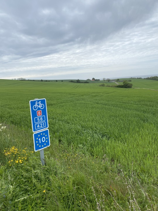
Calling all cycling enthusiasts! The Tennessee Department of Tourist Development (TDTD) has launched an exciting new program designed to entice cyclists from across the country to explore the state's natural beauty on two wheels. Bike Tennessee offers a curated collection of 52 scenic road cycling routes, meticulously mapped and readily accessible through a user-friendly app. Let's delve deeper into this innovative program, the scenic routes it encompasses, and the potential it holds for both cyclists and Tennessee tourism. Tennessee Unveils Bike Tennessee Hit the Backroads, Discover Tennessee's Charm: The Essence of Bike Tennessee Bike Tennessee goes beyond simply offering cycling routes; it's an invitation to immerse yourself in the unique character of Tennessee. Here's what sets this program apart: Unveiling Scenic Routes: The program boasts 52 carefully chosen routes, winding through picturesque landscapes, charming towns, and breathtaking natural wonders. Embrace Sustainability: Cycling offers an eco-friendly way to explore, aligning perfectly with the growing demand for sustainable travel experiences. Authentic Tennessee: Bike Tennessee encourages riders to discover the hidden gems and local charm that define Tennessee's character. Effortless Navigation: Ride with GPS Makes Exploring a Breeze Partnering with the popular cycling app Ride with GPS, Bike Tennessee ensures a seamless user experience: Ambassador Status: Tennessee's designation as a Ride with GPS ambassador guarantees easy accessibility to all 52 routes within the app. Detailed Navigation: Each route is meticulously mapped, providing cyclists with precise turn-by-turn navigation and route information. Enriching Ride Descriptions: Detailed descriptions provide valuable insights into the terrain, waypoints, and hidden gems along the way. This allows cyclists to tailor their experience and discover hidden treasures. Customization Options: The app allows for modifying routes to suit individual preferences and fitness levels. Experience Meets Expertise: Creating Routes for All Levels The Bike Tennessee program was developed with expert guidance: Professional Collaboration: The routes were meticulously crafted in collaboration with Shannon Burke, a seasoned cycling guide with over a decade of experience. Safety First: Route selection prioritized safety and scenic beauty. The 1,739 miles of mapped routes offer primarily rural, low-traffic experiences, perfect for a relaxed and enjoyable ride. Focus on Scenery: The program incorporates some of Tennessee's most stunning landscapes, including 14 routes venturing through Tennessee State Parks. Cyclists can expect breathtaking vistas and immersive natural experiences. Economic Boost: Bike Tennessee Fuels Tourism Growth Bike Tennessee isn't just about offering cyclists a fantastic experience; it also has a strategic economic purpose: Tapping into a Growing Trend: Cycling tourism is a thriving industry, and Bike Tennessee positions Tennessee to capitalize on this growing market. Economic Impact: The program aims to leverage the popularity of cycling to increase visitation and economic activity across the state. According to the Outdoor Industry Association, outdoor recreation already generates $11.9 billion for Tennessee.
#BikeTennessee#cyclingcommunity.#cyclingroutes#economicimpact#outdoorrecreation#RidewithGPS#sceniclandscapes#sustainabletravel#Tennessee#TennesseeUnveilsBikeTennessee#tourism
0 notes
Text
2. International Coffee Outside Day
2022 haben die Leute des von RideWithGPS, das Routenplanungstool das ich seit Jahren nutze, den 1. Oktober zum International Coffee Outside Day erklärt. Dieses Jahr findet der International Coffee Outside Day zu zweitem Mal und zwar am Sonntag, den 1. Oktober, statt!
Die meisten Treffen zum Rausfahren, Kaffee kochen, Plaudern und Chillen finden in den USA, der Heimat von RideWithGPS, statt. Aber…

View On WordPress
0 notes
Text
Self-Supported Berlin -> Copenhagen
Last summer (2022) I biked from ~Berlin to Copenhagen with a friend. A week of gorgeous riding on pavement and some dirt, carrying all our gear but staying in hotels to avoid the need for camping equipment, through a mix of rural landscapes, quaint towns, and cities.

It started with flying into Berlin, checking my boxed bike and a lightweight duffel bag that just held two panniers of gear. I reassembled the bike in a train station in the city, hooked my panniers onto it, wadded up the duffel bag in the bottom of one of the panniers, and rode away...


There's a recommended scenic bike route from Berlin -> Copenhagen, which partly follows the EuroVelo 7 route, with more useful detail including GPS tracks on the Komoot Berlin->Copenhagen page (I downloaded those and wrangled them into RideWithGPS on my phone, and onto a dedicated GPS bike computer I was trying out for the first time).
There's also great paper map book we used that highlights the route page by page (it's in German only, but that doesn't really matter for a map, and my friend spoke German). It's available in your typical map stores in Germany but hard to find in the US-- I ended up spending the extra money to mail order a copy from Stanfords UK ahead of time. I think it would be reasonable to do the entire ride just with this map book and no GPS, but we liked having both.
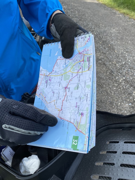
Overall, the paper map and the GPS route both seemed to match reality on the road 95% of the time, though we sometimes took alternate routes where something had changed, or we saw a physical bike route sign by the road that didn't match our map, or we just saw an interesting dirt path to detour onto.
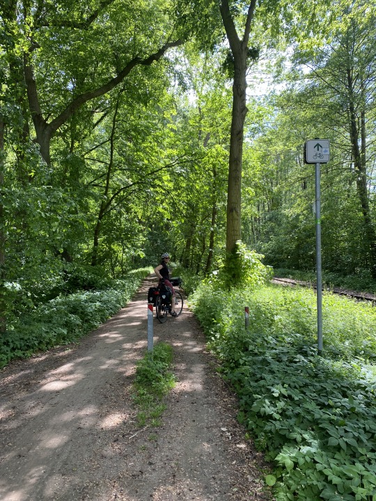
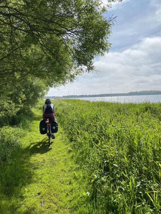
The road surfaces varied. Other than when we had to pass through cities, many of them were a mix of quiet country roads (good pavement, few cars), paved bike paths paralleling main roads (the last rainy image below is a typical two-lane bike path in the countryside of Denmark, as nice as the main road nearby), or gravel roads cutting through forests:


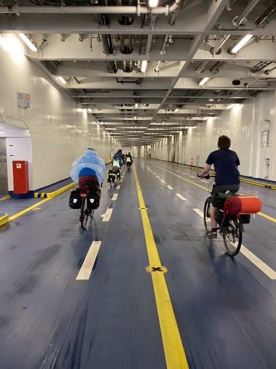
There were a handful of sections with more unusual surfaces, from dirt paths to cutting through a port to get to a ferry, all fun in their own ways:


We ate a lot of white asparagus, cheese, meats, and bread (many hotels had great good protein-heavy breakfasts, and in a handful of towns we rented an apartment and cooked):


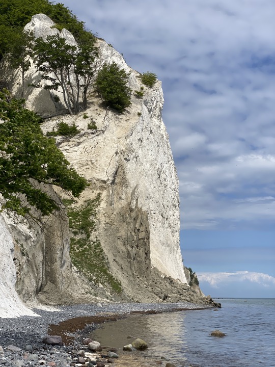
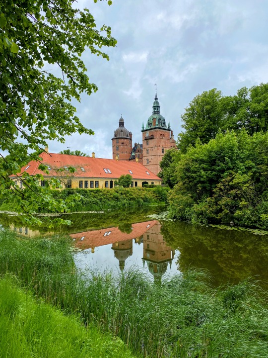
And I'll say again-- it was beautiful. We were never deep in the wilderness, but we passed farm fields, historical castles, the chalk cliffs of Møns Klint, and more. I still think about this a year later.

Finally, a week and ~500km later, we rolled in to Copenhagen and parted ways (I then traveled on to the island of Bornholm for a more lazy vacation-with-occasional-cycling).
A few other highlight memories, the experiences you can't plan but can happen when you explore:
Rain and chilly weather on one grey day-- I wanted a break. We were out in a rural area, but I looked on google maps and saw a small cafe symbol in a nearby town. We had to explore a bit to find it-- down by a harbor where nothing else seemed open. And... it was open, cozy, and full of cheerful people chatting, and we got amazing grilled cheese sandwiches while we took a break from the rain to warm up. (Hårbølle Havne Høker)
Biking past rolling rye fields on a windy day, their silvery ripples looking like ocean waves out of the corner of your eye.
Biking along the North Sea, coming to a dock jutting out into the water. Getting convinced to jump in the very cold ocean. And then getting ice cream afterwards (and there was a convenient public changing room with free hot showers nearby).
The best schnitzel and white asparagus of the trip with some house-made plum schnapps, in the unassuming tiny hotel restaurant in Bützow (I think it was the only hotel in town, the Hotel Bützower Hof).
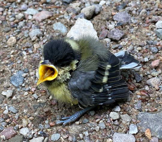
Biking for an hour or two on a dirt road in a forest without seeing another living soul. Then coming across a tiny (abandoned?) baby bird crying in the middle of the road, and moving it off the road with a leaf. I know it probably didn't make it, but we had to do something.
Seeing a sign for a mountain bike detour, and taking it (only had to walk one short section).
Stopping for a beer at tiny microbrewery cafe just off the ferry (Café Købmandsgården), and ending up chatting with the brewer for a while and getting to taste beers-in-progress in the Brite tanks.
A few notes on route and timing:
We debated how much time to set aside for this, and settled on a goal of ~60-105 km (40-65 miles) per day over the course of seven days. We felt we could ride it faster, but made a conscious decision to aim for this pace for a few reasons:
This is vacation. We want to be able to stop and spend plenty of time at historical sites and interesting cafes we came across without feeling hurried.
There were a handful of gravel and dirt alternate routes that I really wanted to ride, and knew would be slower.
There was the possibility of heavy rain part of the week, and the certainty of some intense headwinds-- we wanted to leave open the option to skip a day of riding if the weather was terrible or at least make it a short day (we got fairly lucky on the rain and didn't need to skip a day, but I'm glad we had the option).
To make that pace work with the time we both had available, we decided to take our bikes on a train an hour out of Berlin and start in Neustrelitz instead of Berlin itself. We're both completionists by nature, so it was difficult at first to accept not riding the entire route... but I'm glad we made that call. When we got to the island of Møn we were blown away by the beauty and decided to spend a morning sightseeing around the island, and only got "back on the road" toward our next hotel around 3pm, so I'm glad we could make that a shorter riding day!
Weather:
We had some intense headwinds on one day, and for a few hours on two other days, but it wasn't as frequent as we expected. And we got rained on lightly along the ride, but only really got soaked on our last day, in the final two hours before Copenhagen-- the perfect time to be cold and wet and ready to sleep in...
Lodging:
We didn't reserve anything before the trip. Instead, each evening we'd look at the maps and figure out where we wanted to get to the next day, then look online and make a reservation (mostly Booking.com, but sometimes it didn't list relevant hotels so we had to do some google maps sleuthing + make some phone calls). I think one or two days we didn't even do this until lunch the day of. Overall, this worked, and it was great to have the flexibility to adjust our plans each day... but the flip side of this is one day we had to push hard for a longer ride than intended to get to a town with a hotel, and another day we almost had to detour 10 miles off route to find one with availability (but it all worked out). If I did this again, I'd probably pre-reserve hotels for Fridays and Saturdays only, since there's a lot of demand from local tourists going out to these scenic seaside towns (especially the isle of Mon).
But hey, without these constraints, we never would have ended up staying in some of the more unusual hotels, like Pension Elmehoj built in a converted retirees home, with bathrooms that look like this:

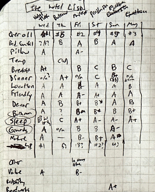
I also found this page in my notebook where, for fun, we ranked every hotel by a range of important criteria :)
A few other lessons learned (or known and reinforced):
Looking back at a notebook I kept along the ride...
Get to major ferries early (perhaps by an hour?). We did some research and planned for this, and it's good we did-- just biking across the massive ferry terminal at Rostock took a while, and we had to buy tickets and get our bikes loaded.
I liked the combination of wool short sleeve t-shirt plus light UV-blocking sun sleeves (saves effort on sunscreen).
I'm glad I brought flip flops, to walk around the hotel or beach in.
Don't make assumptions about other's travel styles, it's good to talk through what you each want out of a trip. For bike touring, I think the key points are (1) how early or late do you like to get up and roll out and (2) how much do you like to stop and detour along the way? (We traveled very well together, but it's good we talked these through before the trip because one of us assumed much earlier morning starts than the other :)
I brought just two pairs of padded bike shorts to alternate between and washed the used pair each night in the hotel sink, hanging it up to dry. It would have been convenient to pack a third pair, as these didn't always fully dry overnight and I had to figure out a way to clip them to my bike rack to dry during the day.
I definitely should have bought chain lube-- I left it at home because I wasn't sure about flying with it, but even with our lightly misty rain I should have been lubing the chain every few days.
I didn't like the screw-on style of bike pump I brought-- I accidentally unscrewed my valve cores (I didn't realize I'd bought tubes with removable valve cores) which was... startling. And I didn't have a good tool beyond my hand and a rag to tighten the valve cores in.
As usual, I brought rain pants and shoe covers but didn't get a lot out of them. When it's lightly raining, they just make me hot and sweaty and aren't needed. When it's raining harder, they only kept my feet dry for an hour or two-- eventually the rain gets in. I may shift to just bringing a rain jacket and extra socks in the future.
Similarly, I often pack leg warmers and then don't need them-- I warm up quickly enough while I'm riding.
Packing:
Generally, I traveled fairly light, with my bike plus two small panniers (10-15L each). At some point I'll write up my packing lists from trips-- every trip I learn more and refine it...
I rode with a hip pack on this trip for the first time. It felt so uncool (who cares) but carrying an extra 1.5L of water and my wallet/passport/snacks/rain jacket even when parking the bike and walking around was awfully convenient...
0 notes
Text
Dc doppler radar

#Dc doppler radar Bluetooth
RDU: Varia display unit, the small dedicated display for when folks didn’t have a compatible display deviceĪnyway, back to the basics first, which is pairing it up to a non-phone display. RTL501: 1st gen Varia radar with ANT+ (looks rectangular) RTL500: 1st gen Varia radar with ANT+ (looks rectangular) RTL511: 2nd gen Varia radar taillight with ANT+ RTL510: 2nd gen Varia radar taillight with ANT+
#Dc doppler radar Bluetooth
RTL516: New 3rd gen Varia radar taillight with ANT+ & Bluetooth RTL515: New 3rd gen Varia radar taillight with ANT+ & Bluetooth RVR315: Smaller Varia radar pod with ANT+ & Bluetooth, no taillight Now, I know that Garmin’s radar naming convention can be a bit higgledy piggledy, so, here’s a quick primer on all radar versions: So you’d get the new smartphone app based compatibility via Bluetooth, the new peloton mode, and the slight increase in battery life. Instead, all of the changes for the RTL515 are additive in nature. If you’re familiar with the existing RTL510, then everything you know is still true. It’s about the same thickness/width however.Īs for the weight, it saves there too – down to 49g:Īnd thus, your boxing experience has now concluded. The pod is obviously smaller than the RTL515, since it lacks a light. In fact, the two units even weigh the same:Īs for the RVR315, I’ve only got a white-box variant of it. I keep wondering: Maybe USB-C hasn’t made it to Kansas yet? Perhaps they’re just aficionado’s of the micro-USB cable? Do their MacBook’s have micro-USB ports on them instead? Just asking for a friend.Īside from the RTL515 logo on the rear, there’s no visual difference between the RTL510 and RTL, save also the tiny Bluetooth icon etched inside the quarter-turn mount: Then in the middle there’s the mounting bits for your seat post – notably, the Varia RTL515/RVR315 now include a third mounting option, for d-shaped seatposts (as well as an aero v-shaped one and a standard round one).Īnd at right is the micro-USB charging cable. You’ve got the radar to the left, which uses the standard Garmin quarter-turn mount. And for that matter, aside from a few tiny text tweaks, the boxes are the same too!Īnyway, inside here’s all the parts in plastic bags…and then not in plastic bags: If you’re a connoisseur of unboxings, you’ll be disappointed to know it’s virtually identical inside to that of the RTL510. What’s in the box:įirst up we’ve got the RTL515. If you found this review useful, hit up the links at the bottom of the post to support the site. They’ll go back to Garmin here shortly and I’ll go out and buy my own through normal retail channels. Oh – and I was sent these media loaner units to test these out. Now – if you’re looking for all the new goodness in one tidy video, simply hit play below: Beyond the battery/Bluetooth/brightness tweaks, the radar works identically to the past. Whereas if you’re looking at one, then you’ll want to weigh whether these new features are worth it versus just getting one of the now-older ones on sale. Though, the TLDR version here is simply that if you’ve already got a Varia radar, there probably isn’t a major reason to upgrade. I’ve been using both units for a month or so now and have a pretty good grasp on all the nuances to them. Though, you’re not riding in tight groups right now anyway – right? In addition to the Bluetooth Smart connectivity, battery life on the larger of the two units is slightly increased, while also adding a new ‘peloton mode’ that reduces the brightness of the steady-on light while you’re in a group, reducing the annoyance of those around you. At launch that includes RideWithGPS’s app, but will likely be expanded over time as other apps pick up support for it. The second smaller new unit ditches the taillight in favor of a smaller form factor.īoth the new lights now include Bluetooth Smart connectivity, making it possible to not only see radar information on a new smartphone app, but it also enables 3rd party smartphone support too. Oh, and actually: There’s two new radars. While this new version looks identical from the outside, it’s not internally – sporting new features and compatibility. Like clock-work, two years after releasing the last version of the Garmin Varia radar, the company has released its now third generation version.
0 notes
Video
instagram
This is such a challenging ride, but it definitely reminded me how far I’ve come in the past year! Thank you to my awesome teammates/friends for supporting me and keeping me moving forward and laughing through it all! #teamintraining #delcotriclub #cycling #frenchcreekirontour (Note that my actual moving time was 3:08:11 according to #RidewithGPS - something happened in the transfer to #Strava then to #relive!) (at Kimberton Fairgrounds)
3 notes
·
View notes
Photo

Posted @withregram • @tourismeprescottrussell Le cyclisme n’est pas un sport, c’est un mode de vie.🚴🏼♀️ . . Cycling is not a sport, it's a lifestyle.🚴🏼 📸:@runningwriter @prescottrussell . . . #recreationaltrail #trail #sentier #sentierrecreatif #prescottrussell #niceview #beaupaysage #paysage #cyclisme #cycling #ride #ridewithgps #sport #lifestyle #modedevie #enjoylife #life #enjoy #friends #relax #familly #instagood #photooftheday #photography #instadaily #livelife #lovelife #fall #bestseason https://www.instagram.com/p/CHgpT9AhUya/?igshid=16grr51xvul82
#recreationaltrail#trail#sentier#sentierrecreatif#prescottrussell#niceview#beaupaysage#paysage#cyclisme#cycling#ride#ridewithgps#sport#lifestyle#modedevie#enjoylife#life#enjoy#friends#relax#familly#instagood#photooftheday#photography#instadaily#livelife#lovelife#fall#bestseason
0 notes
Photo


Another #RideWithGWD story is ready to be told, with destination Venezia to attend Biennale di Arte 2017 in collaboration with Land Rover Italia & Valstar Milano 1911.
ph. @charleyph
read more here: bit.ly/GWDAtBiennale2017
GWD
Your daily inspiration reference for Men’s lifestyle
10 notes
·
View notes
Photo

#Repost @omtm.cc
・・・
Looks like we’re on for a bit of rainbow magic and trailsport tomorrow out of Ripplebrook. If you like bikedancing, forest roads, CCC-era ranger stations and off-brand baked goods we’ll see you at the Ripplebrook Camp Store at 9am
—————————-
<<ROUTE DETAILS IN PROFILE>>
—————————-
#omtm#repost#sportpacking#bikedancing#shredzeppelin#ridewithgps#gratefulshred#seekandenjoy#ridehifi#ripplebrookbackroadsv2#unpavedomtm2017#caniplaywithradness#roadslikethese#fromwhereiride#trailcraft
4 notes
·
View notes
Photo

Warming up around a fire after a big day of bikepacking to enjoy a cup of wine and some much deserved @goodtogofoods! . . . #bikepacking #fatbike #fatbikedotcom #cycling #valleedelajacquescartier #valleedubrasdunord #ridewithgps #stravacycling #tourismequebec #goodtogo (at Secteur Tourilli)
#goodtogo#valleedubrasdunord#fatbikedotcom#ridewithgps#bikepacking#stravacycling#cycling#valleedelajacquescartier#tourismequebec#fatbike
2 notes
·
View notes
Photo

Almost there... we'll be up and running in 30mn at the #alpedhuez village for the @haute_route event. We have the special #alps #pyrenees and #triplecrown prints on display, with rider stat personalisation. @jim_c_1985 good luck with your TT mate, see you at the village. 🚵♀️💪🏼. . . . . #hauteroute #cyclosportive #infographics #dataart #strava #garmin #ridewithgps #personalisation #alps #velo #huez #alpedhuez #ortlieb #massifcentral #maceobtour #mapmyride #roadporn (at Alpe d'HuZes)
#alpedhuez#velo#hauteroute#infographics#personalisation#garmin#strava#pyrenees#maceobtour#triplecrown#ridewithgps#dataart#cyclosportive#ortlieb#roadporn#mapmyride#massifcentral#huez#alps
1 note
·
View note
Photo

Recently, I got to participate in my second Crit series (@tourofamericasdairyland)ever!!! This was by far the longest consecutive days of racing for me, 7 days😲. It opened up a new world to me. It tested my body and my mind like never before🫠. 🙌🏾 I enjoyed racing my road bike in big fields, testing myself, trying different tactics, and doing all this with Black and Brown women. I got to experience some real pro ‘ish… ie having meals prepared so I can be my best self, having a tent setup at the races for pre/post race, well organized itinerary (nod to Alexa @rockcognoscente) and folks to cheer us on🙌🏾. ✨ It takes a village to be successful and stay the course. Thanks to the support of @theeabundanceproject @the_blackfoxes @ayesuppose @lkmoy @livcycling @ridewithgps ✨ A little late on sharing about the experience, thanks for reading if you made it this far🥰 https://www.instagram.com/p/CgM57zLOWMM/?igshid=NGJjMDIxMWI=
3 notes
·
View notes

Text
San Francisco to Seattle
17 May - 5 June 2021
I thought it might be good to provide a summary of my recent 20-day ride from San Francisco to Seattle. Each day resulted in its own entry (linked below), but I wanted to provide a broader overview. (LINK: post about gear and bike setup).
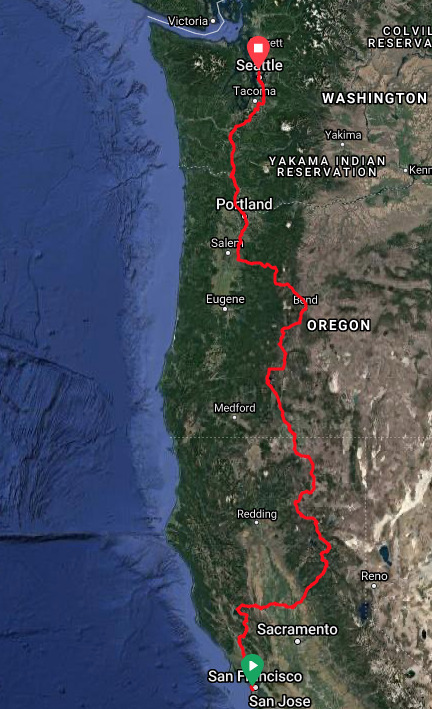
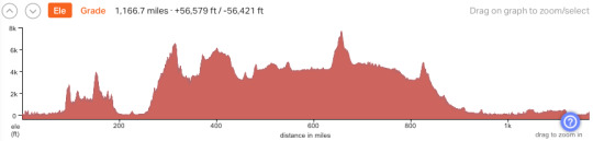
My route covered 1187 miles over 20 days (I-5, by car, is 820 miles). I averaged 62 miles per day, not counting my rest day (daily miles ranged from 32 to 88). I chose to take an inland route, in part because the roads were less trafficked and in part because I have a fondness of the wide open spaces of the interior. If I had been riding north to south, I might have opted for the coast, but there was no way I was going to add persistent northerly headwinds to an already very hilly and heavily trafficked (but very scenic) route.
Here are the links to individual days:
Day 1. 5-17. San Francisco to Petaluma. Pacific Ocean. Golden Gate Bridge. Dinner with M.
Day 2. 5-18. Petaluma to Clearlake. Santa Rosa. Chalk Hills. Ida Clayton Road. Middletown.
Day 3. 5-19. Clearlake to Williams. Clear Lake. Bartlett Springs Road. Leesville Grade.
Day 4. 5-20. Williams to Browns Valley. Sacramento River. Sutter Buttes. Central Valley.
Day 5. 5-21. Browns Valley to La Porte. Uphill, all day. Log trucks and wet snow.
Day 6. 5-22. La Porte to Quincy. North Sierras.
Day 7. 5-23. Quincy to Bogard. Spanish Fork. Taylorsville. Moonlight Pass. Westwood.
Day 8. 5-24. Bogard to Fall River Mills. Old Station. Hat Creek. Cassell Road.
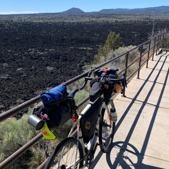
Day 9. 5-25. Fall River Mills to Lava Beds. Bieber. Lookout. Tionesta.
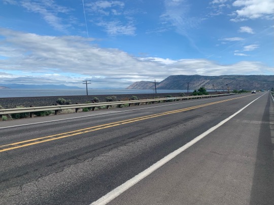
Day 10. 5-26. Lava Beds to Klamath Falls. Lava. Tule Lake. Oregon.
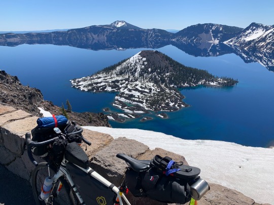
Day 11. 5-27. Klamath Falls to Mazama Village. Klamath Lake. Crater Lake NP.
Day 12. 5-28. Mazama Village to Davis Creek. Crater Lake. US97. Cascade Lakes.
Day 13. 5-29. Davis Creek to Bend. Sun River. Deschutes River Trail.
Day 14. 5-30. Bend to Santiam Pass. Sisters. Lost Lake.
Day 15. 5-31. Santiam Pass to Sublimity. Detroit.
Day 16. 6-1. Sublimity to Portland. Silverton. Oregon City. The Willamette River.
Day 17. 6-2. Portland. Rest day.
Day 18. 6-3. Portland to Kelso. US 30 along Columbia. Longview.
Day 19. 6-4. Kelso to Yelm. Castle Rock. Chehalis. Tenino.
Day 20. 6-5. Yelm to Seattle. Spanaway. Puyallup. Green and Duwamish Rivers. Downtown.
The following is a link to the entire route in RideWithGPS. Note that this is a close approximation of the route, but not necessarily exact. The day-by-day posts above link to the actual ride data, which show enough detail to capture wrong turns, side trips, and exactly where I stopped for food, camped, or pulled off for a view.
My steepest climbs were Ida Clayton Road in Sonoma County on the second day and Bartlett Springs Road east of Clear Lake on the third. My longest climb was on the western slope of the northern Sierras, which rose from near sea level to over 6500'. Day 5, from Browns Valley to La Porte, resulted in a total climb of almost 8800’, the most I’ve ever done in a day. Other notable, but easier climbs included Moonlight Pass north of Taylorsville (Day 7), the climb to Crater Lake (Day 11), and the ascent of Santiam Pass (Day 14). The highest point on the ride was 7600’ along the west rim of Crater Lake (Day 12). I crisscrossed the Pacific Crest Trail numerous times in CA and OR.
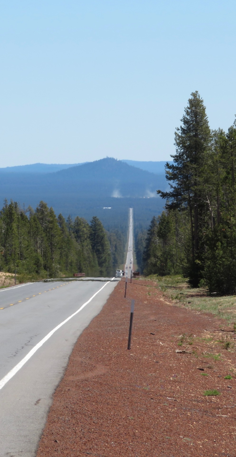
Geologically, this was a very volcanic route. Lots of lava. Lots of cones and craters and calderas. I saw Sutter Buttes, Lassen, Shasta, Medicine Lake (Lava Beds), McLaughlin, Mazama (Crater Lake), Thielsen, Diamond Peak, Newberry (Paulina Peak), Bachelor, The Sisters, Washington, Jefferson, Hood, Adams, St Helens, and Rainier. Some were closer than others, but they were all around me.
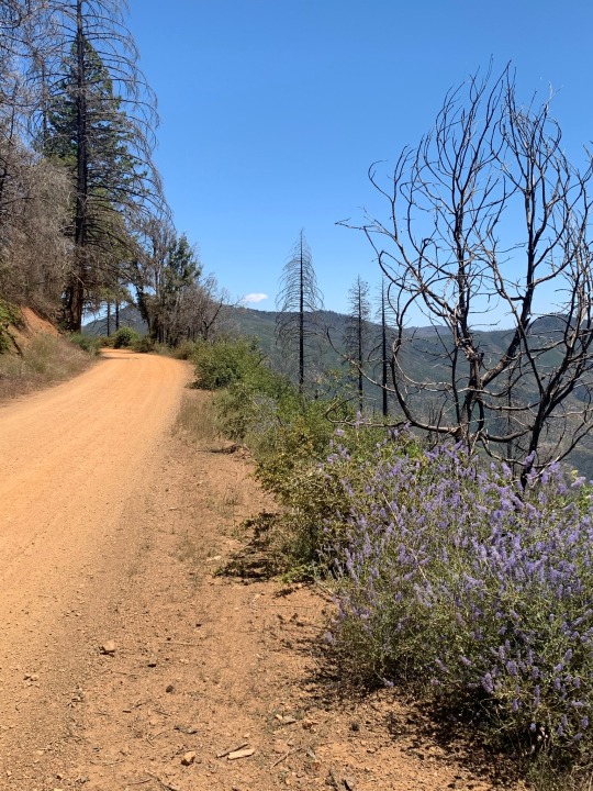
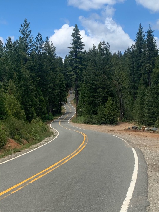
While there were some great (rough, difficult, but sometimes wonderful) gravel segments, a vast majority of the ride was on pavement. The most memorable gravel was on Bartlett Springs Road and on Moonlight Valley/Old Town Road between Taylorsville and Westwood. The Deschutes River Trail was a great dirt ride, mainly easy single track, but made me glad I was riding a gravel bike with a bike packing setup and not my touring bike with panniers. The Ida Clayton Road north of Santa Rosa and Hill Road east Lava Beds National Monument were paved, but badly, and should probably count as gravel!
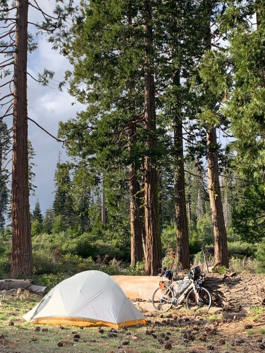
I stayed in motels when I could and camped when I needed to. Motels are often generic and uninteresting (not always) and expensive, but they have running water and hot showers, outlets for charging, a place to wash out and dry clothing, and are much warmer when you get up in the morning. They are usually near stores and restaurants and usually have WiFi and cell service (not always). Camping is more rewarding and more immersive. Cold nights. Full moons. Misty lakes. Wildlife. Noisy birds. There were a couple of regular campgrounds and a bunch of wild camps or primitive sites that were nearly wild.
Highlights are always tough (and often the highlights of bike trip are moments not spent on the bike). The Golden Gate Bridge. Dinner with M on her birthday along the Petaluma River. Dropping down the Leesville Grade. Indian Valley and Young's Market in Taylorsville. The view of Lassen and Shasta over the Hat Creek Valley. The patio at the Fall River Hotel. Crater Lake. Riding into Bend along the Deschutes River Trail. The morning mist on Lost Lake west of Santiam Pass. Coffee at Dragonfly and breakfast at Besaw on my rest day in Portland.
And then there are the people and the conversations. The volunteers at the randoneuring check point in Quincy. Scott and Barb and Les in Fall River. Tom at Lava Beds. The guy in the coffee shop in Klamath Falls. The family at Crater Lake. Another family at the coffee shop in Sisters. Many others.
Ultimately, what impacts me the most is the notion of riding alone through a vast landscape. The surroundings change slowly because you are moving slowly. But they do change, and rarely do you go half a day without finding yourself in a very different kind of place. Over almost three weeks there are mountains and desert and lava and forest and city and ocean. The remoteness and the solitude is both a compelling attraction and a big source of stress. It’s wonderful, scary, and a little overwhelming, which is probably why it is so powerful emotionally. I enjoy the challenge, the anticipation, and doing something that's a little more difficult in a life that's otherwise remarkably easy. Of course, when I'm doing it, I often wish I was home, going out for the routine coffee, sitting in the back yard, and puttering around the house.
There are always what-ifs. I discovered and fixed a loose derailleur on the second day before something disastrous happened. I had no flats or other mechanical problems, other than constant issues with a drive chain desperately in need of a cleaning. If it had been colder AND wetter, things might have gotten unpleasant, but as it was, weather was pretty ideal most of the time. If my periodic toothache or my sore peroneal tendon had gotten worse, there might have been a reckoning. I was passed by thousands of cars and trucks, but if they were texting or on their fifth beer, I didn’t notice (but I did think about it). Hypothermia and dehydration should always be concerns, but I brought proper gear and planned my route carefully and flexibly, making those outcomes highly unlikely. Ultimately, I suspect the most dangerous aspect of this kind of ride is my own inattention. It’s hitting something, catching the edge of pavement, or sliding in loose gravel, and taking a bad spill.
COVID impacted the trip in the same way it affects our broader lives these days. Rules, attitudes, and adherence varied from place to place and not always in the patterns you might expect - but that's true about a lot of things when traveling. The biggest issue was that places I normally rely on weren't always available - from fast food dining rooms to bathrooms. It was harder to get out of the sun, refill water bottles, charge batteries, or find WiFi.
3 notes
·
View notes
Text
Join us for our Hike-A-Thon event!


Registration for our Hike-A-Thon is open

Join the New Jersey Highlands Coalition for our first Explore the Highlands Hike-A-Thon!
Turn you passion into purpose!
Get outside to hike, cycle, or paddle to win some amazing prizes while supporting the New Jersey Highlands Coalition!
How it works:
Participants hike, cycle, and paddle throughout New Jersey, logging their miles, sharing their accomplishments, and raising funds to support the organization that protects the Highlands and its abundant recreational opportunities. Together we'll share photos and stories of our adventures on social media using #ExploreTheNJHighlands.
Those participants who log the highest number of miles or who raise the most funds will be in the running for some splendid prizes from our wonderful community partners.


Event details:
- Registration to the Highlands Hike-A-Thon is $20. You can register using this link -> Run Sign Up.
- Participants log their miles using the Run Sign Up site. We recommend using an activity tracker such as Strava, RideWithGPS, or similar to track your miles and make it easy for organizers to verify.
- Every participant will be able to set up their own fundraising page through Just Giving to raise money.
- Explore the Highlands Hike-A-Thon will run between June 1st, 2021 and July 11th, 2021.
Throughout the Event the NJ Highlands Coalition will share our favorite itineraries with and resources to explore new areas and try new activities in the Highlands.
The Prizes!
Any participant who raises over $1,000 can choose three of the following:
VIP tickets to our upcoming Fall Car Trek and Passport Pubcrawl
A guided hike in the Highlands
A two hour paddleboard excursion for two at Monksville Reservoir (paddleboards provided)
Full set of trail maps (11 maps) from the NY/NJ Trail Conference
Any participant who raises over $750 can choose two of the following:
Tickets to our upcoming Fall Car Trek and our upcoming Passport Pubcrawl
A guided hike in the Highlands
A two hour paddleboard excursion for two at Monksville Reservoir (paddleboards provided).
Any participant who raises over $500 will receive:
Tickets to our upcoming Fall Car Trek and Passport Pubcrawl.
A personal guided hike or ride with the Highlands Coalition.
The two hikers/bikers/paddlers to track the most miles will receive:
Northern New Jersey maps from the NY/NJ Trail Conference
More prizes to be announced!
There will also be prizes for participants at the top of these categories:
Freewheeler Award - For the biker who rides the most miles
Riverkeeper Award - The paddler who floats the most miles
Highlands Rambler Award - The hiker who runs/walks the most miles
NJ Highlands Hike-A-Thon
Sponsors & Community Partners


The New Jersey Highlands Coalition
We represent a diverse network of organizations - small and large, local, regional, statewide and national - and individuals with the common goal to protect, enhance and restore the New Jersey Highlands and to preserve the quality and quantity of drinking water for the 6.2 million people who depend on Highlands water.
Help protect the New Jersey Highlands

“Of all the paths you take in life, make sure a few of them are dirt” – John Muir
www.njhighlandscoalition.org • [email protected]
New Jersey Highlands Coalition · 508 Main St · NJ Highlands Coalition · Boonton · New Jersey · 07005
1 note
·
View note
Photo

First 40+ on #trekmadone5.2 since breaking #collarbone #ridewithgps (at Borgo Bazziganta)
0 notes
Last Seen Blogs