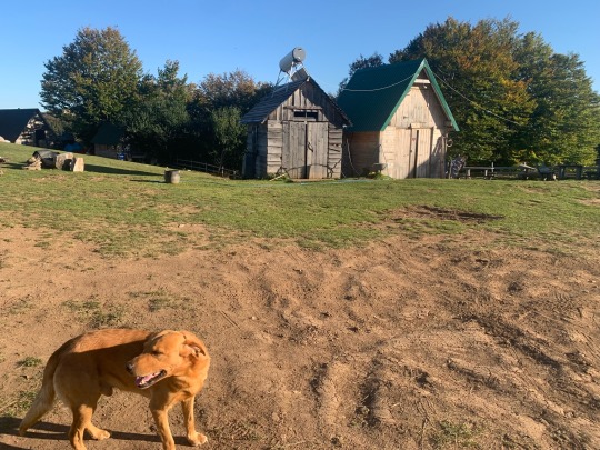
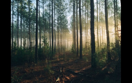
#Sheep Pass Canyon
Text

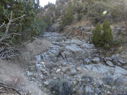
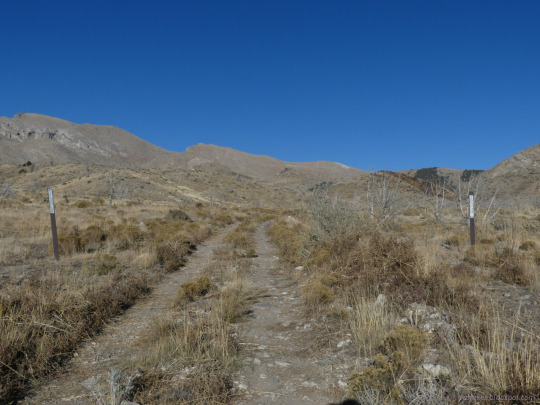
Caliente Field Office BLM, Nevada
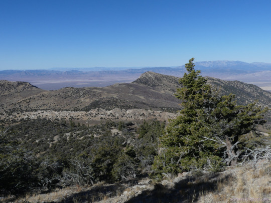
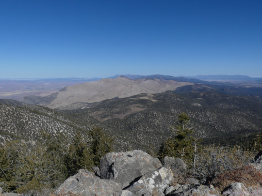
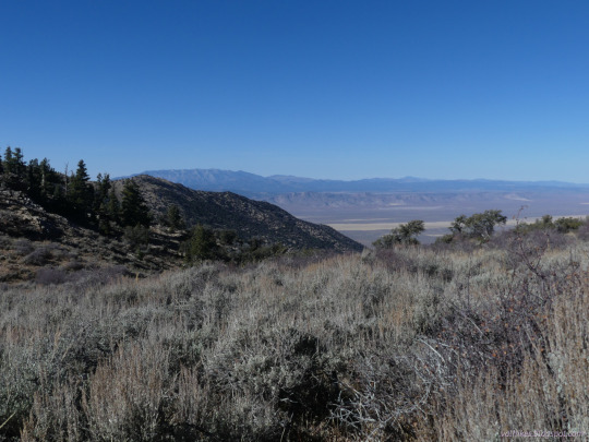
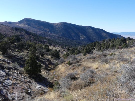
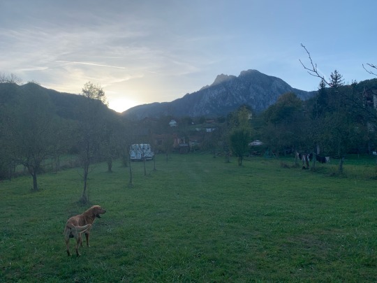
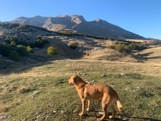
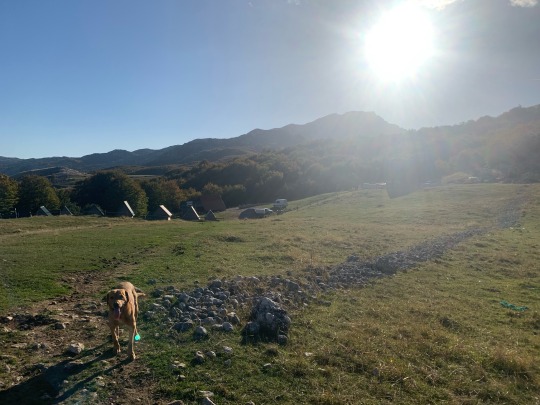
My second day backpacking the South Egan Range Wilderness, I climbed up the high point in the morning. That's Adams benchmark. Then I got back to Ninemile Canyon for water, then traveled down to Sheep Pass Canyon and found camp on a small branch.
#hiking#nature#landscape#travel#hike#outside#mountains#peak bagging#peakbagger#high point#South Egan Range Wilderness#Nevada#Bristlecone BLM#Caliente BLM#Ely BLM#backpacking#public lands
4 notes
·
View notes
Photo


Petition and map from John Muir and other founders of Sierra Club protesting a bill to reduce the size of Yosemite National Park, 1/2/1893.
Record Group 233: Records of the U.S. House of Representatives
Series: Petitions and Memorials
Transcription:
To the Chairman of the Committee on Agriculture House of Representatives Washington, D.C. Dear Sir, Whereas at a meeting of the Sierra Club of Saturday, November 5th 1892, said club being a corporation formed for the purposes, to with: "To explore, enjoy and render accessible the mountain regions of the Pacific Coast; to publish authentic information concerning them; to enlist the support and co-operations of the people and the government in preserving the forests and other natural features of the Sierra Nevada Mountains" a resolution was introduced and unanimously adopted directing the Board of Directors to prepare a memorial to Congress against Bill H. R 5764 introduced by Mr. Carminetti and to use every effort to defeat it, Therefore The Board of Directors of the Sierra Club in accordance with the above resolutions do respectfully and emphatically protest against the diminution of the Yosemite National Park situated in California as contemplated in Bill H. R. 5764 introduced by Mr. Carminetti and referred by the House of Representatives to your honorable Committee As shown in the accompanying map all
[page 2]
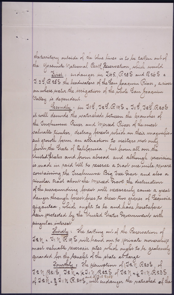
the territory outside of the blue lines is to be taken out of the Yosemite National Park Reservation, which would First: endanger in J.HS., R25E and R26E + J.3S, R25E the headwaters of the San Joaquin River, a river on whose water the irrigation of the whole San Joaquin Valley is dependent. Secondly: in J1S, J2S.R19E+ J1S, J2S.R20E it will denude the watersheds between the branches of the Tuolumne River and Merced River of the most valuable timber, destroy forests which in their magnific- ent growth from and attraction to visitors not only from the State of California, but from all over the United States and from abroad and although provision is made in paid bill to reserve a trail one mile square containing the Tuolumne Big Tree Grove and also a similar trail about the Merced Grove the destruction of the surrounding forest will necessarily cause a great danger through forest fires to these two groves of Sequoia gigantea, which ought to be and have heretofore bee protected by the United States Government with singular interest Thirdly: The taking of the Reservation of J2N+ J1N R19E will hand over to private ownership most valuable reservoir sites which ought to be jealously guarded for the benefit of the state at large Fourthly: The exemption of 1/2 J2N.R20E, of J2N R21E, J2N + 1/2 J1NR22E of J2N+ 1/2 J1N.R23E of J2N +3/4 J1NR.24E and of J1S R25E will endanger the watershed of the
[page 3]
tributaries of the Tuolumne River as it passes through the Grand Canyon of the Tuolumne River + finally through Hetch Hetchy Valley, a valley which in grandeur + uniqueness is in many respects the peer of Yosemite and will in future form one of the principal attractions of the Sierra Nevada of California If the Territory of the Yosemite National Park should be reduced in accordance with the bill H.R 5764, the dangers to guard against which the Park was orig- inally set aside, would again arise, the herds of sheep which now for two seasons have successfully been kept out of the reservation would denude the watersheds of their vegetation, the forest fires following in the wake of the herds would destroy the magnificent forests and threaten the reservation itself and the timber of price- less value of the speculator. The Directors of the Sierra Club respectfully point out that Senate Bill No 3235 proposed by Mr. Paddock will meet any objections in the interest of mining or farming industries, if there be any, to the continuance of the present limits of the Yosemite National Park Reservation. John Muir J.H. Senger, President Sierra Club Secretary Sierra Club Warren Olney First Vice - President Sierra Club San Francisco, Jan 2nd 1893
[page 4 image description] Map of Yosemite, labeled “MAP OF THE YO SEMITE NATIONAL PARK”. Part of the map is outlined in blue.
#archivesgov#January 2#1893#1800#Yosemite#Yosemite National Park#environment#conservation#Sierra Club
52 notes
·
View notes
Text
thinking about it now, I realize how much I miss the desert
not las vegas (though I miss how alive the city was and how you could do anything even at 3am, for a perpetual night owl it was great)
Vegas was dirty and brown and covered in dust and sand all the time.
The city is a dust bowl, centered in a ring of mountains.
Leave the city. Head east towards the lake.
Beautiful wildflowers in spring. Mountains painted like rainbows. Dormant Volcanoes rising from flat earth. An entire valley red like fire with multiple biomes and ancient wall paintings. If you know where to look, you can find ancient petrified wood. If you know where to look, there are places of life, beautiful refuges hidden among the landscape.
West, towards The Mountain, more painted rocks, more flowers, and evergreen forests rising up and up and up. In the winter it's covered in snow. The rest of the year there are springs and waterfalls and life ranging from chipmunks to deer and elk, herds of bighorn sheep and mountain lions. (a bit more north than west are hidden valleys)
North, into the great basin, more painted mountains, deep canyons and the oldest trees in the world. Gnarled things clinging to the cliffside, survivors thousands of years old. (and more signs of early human life from kilns to more paintings and buildings carefully preserved and restored)
South, deeper into the desert, the mountains are painted still, and there are hidden valleys and passes filled with forests. Salt flats, beautifully desolate.
6 notes
·
View notes
Text
Each of his steps was powerful enough to shake the very earth. The pathetic tinies at his feet nothing more than bugs under his hooves as the sheep rampaged through the city. As he made his way through the streets, pushing away hip high skyscrapers, a shadow passed overhead.
Before the giant could react, a massive object crashed down in front of him, the impact sent him reeling back as the the rest of the city he was rampaging through vanished. Shaking, he looked up to see a massive paw with toes bigger than his entire body sitting in front of him.
His eyes trailed up a leg that loomed higher than any mountain, up a torso that could fit entire cities on it with ease until his eyes met with a monolithic mouse, staring back down at him with amusement. "Oops!" The massive rodent mused. "Sorry little guy, didn't see you there."
The mouse's voice shook him to the core. Before the sheep could pick his jaw off the ground, the foot lifted again as the mouse stepped away, crossing a distance that would take him minutes in a single step as he made his way past the horizon, one earthshaking step at a time.
He sat in the crater his body had formed among the buildings that had withstood the force of the mouse's step, shaking as he saw the canyon that remained of the rest of the city. The sheep swallowed, still unable to even move from fright. Maybe he should watch his step more.
9 notes
·
View notes
Text
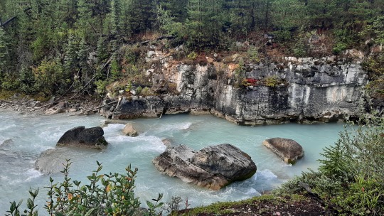
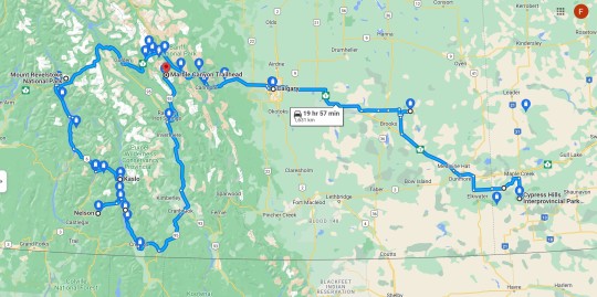
BC: East Kootenay
When I left Nelson, there was no longer ash falling on the car but still a lot of smoke and the sudden 10C drop in temperature from the day before held out, so suddenly I was wearing a sweater & scarf again!
Ferries always make me think of holiday (when we were little, we would take the ferry across the Mediterranean from Tunisia to the Netherlands & France, maybe that's why?), so even with poor view I enjoyed the 35-minute (free!) crossing of Kootenay Lake. Upon landing, I visited the Pilot Bay lighthouse which was in use from 1905 to 1993 to guide ships on the long lake on days like this with poor visibility... I was able to climb tiny stairs to the top but the view remained the same; none! 😂 Somewhat further south, I walked a bit on Lockheart Beach and could only imagine the mountains surrounding it.

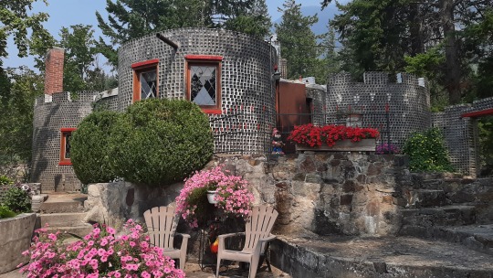
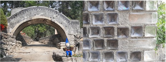
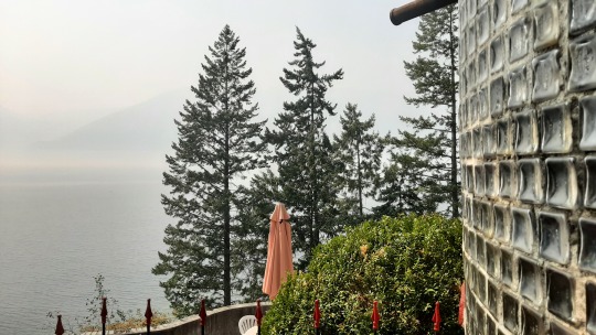
Still further south on the lake I visited the Glass House, completely made out of embalming bottles that an undertaker had collected through his job (the strangest hobbies one can have!?!😁) and which is still lived in during the winter by his descendants.
Off the lake now, the town of Creston has two grain elevators that I had wanted to take a photo of (given that we're west of the Rockies instead of on the prairies) but they were in such a bad state that I didn't even bother stopping.
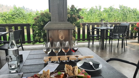
I had planned to do some wine tasting in the famous Okanagan wine valley, so instead I did one in the up & coming Creston wine valley at the Baillie-Grohman winery... out of the four that I sampled, the pinot gris was my favourite to go with the baked brie. 😊
I stayed overnight at a nearby private campground, which interestingly had simple garbage bins right next to my site instead of bear/raccoon/other wildlife-proof ones... having been conditioned to always keep food securely packed away, it was a bit unsettling but luckily the night passed uneventful. 👍

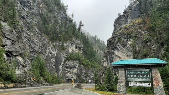
Next day, driving northeast up to Radium Hot Springs where there were another two large fires, the smoke was getting worse so I didn't feel like doing anything and cancelled all other attractions I had earmarked as potentially interesting; any viewpoints ofcourse, paddling on a pretty lake, a trout hatchery and a hike to the source of the Columbia River... With the town of Nelson having been unexpectedly the farthest west on my trip in BC, I had hoped that things would improve going back so it was disheartening that nothing changed. I had not wanted to travel to East Kootenay in the first place, and I did not like it now! 😣😅
Instead, I drove straight to my campround at Radium, set up shop and then had a soak in the nearby hot springs which improved my mood. After a tasty jambalaya dinner, I spent the evening playing solitaire and won three times in a row! 😄


In the morning, it rained but there was no smoke, and you cannot imagine how happy I was... I had not thought that I would be so glad to see proper clouds again!😂
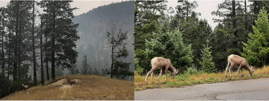
At the hot springs the previous day, I had already spotted the first few bighorn sheep (most without big horns though) and now I saw quite a few more on my way out along the canyon. Bighorn sheep don't lose their horns annually such as deer so they grow longer each year, and you can determine their age from the horn rings just like trees... roadkill is unfortunately a major issue, but this was not going to be by me (the duck was enough!!) so I slowed down properly. 👍
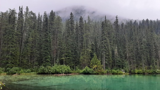
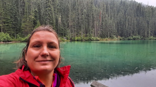
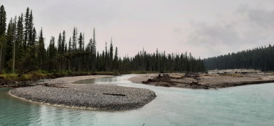
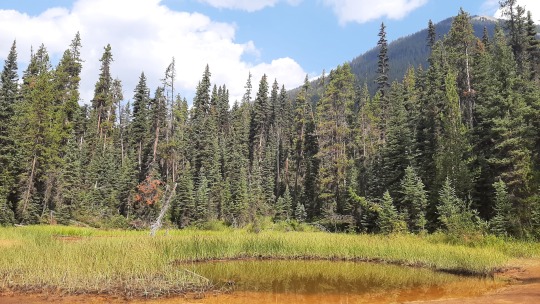
In Kootenay National Park, I checked out Olive Lake which is spring-fed and has pretty colours but the rain made it a brief stop.
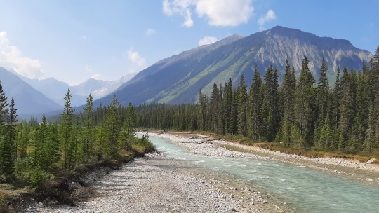
The road follows the Kootenay river, which with its light-blue glacial water was a bit monotone with the grey-white sky, but still pretty and with an impressive flow, not to swim in!
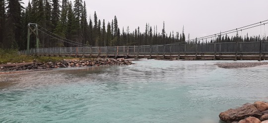
I started a hike crossing the river towards a lake but turned around at the bridge, as I didn't feel at ease. August is prime berry time for bears and as I didn't see anyone else on the trail, it felt a bad choice to continue... I'm not too concerned about black bears as they tend to flee when they see humans (unless they feel threatened), but grizzly bears are aggressive and will attack, against which my hiking poles & whistle are not really up to 😯. Lesson learnt; if I ever come back to BC and the Rockies, I would want to be in a larger group so that I can hike more!

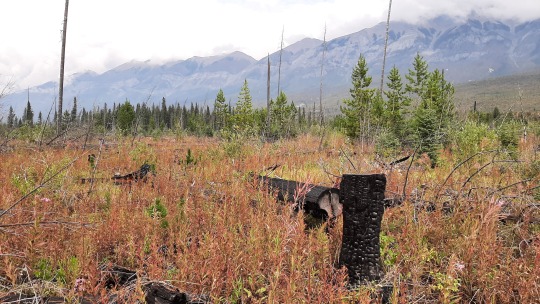
I did do a small hike in a fire restoration area as the parking lot was full and there were more people on the trail. The scenery was a bit haunting with a lot of dead trees but at the same time it had a positive feel to it as new plants were taking over. The area has had four fires in the last 20 years, some natural and some burned on purpose to create meadows, which does not only reduces the risk of devastating, out-of-control fires but also provides important habitat for wildlife who depend on the grasses & shrubs for their survival.

Although there was a tiny bit of blue sky during the hike, once I got to the Marble Canyon campground, it rained and rained and rained, so I sat comfortably in the car reading a magazine until there was a dry spell, set up the tent in record time and continued reading there when the rain restarted. 😁
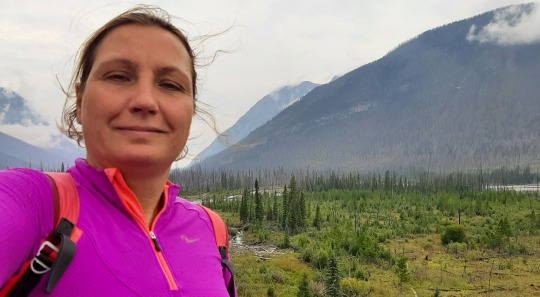
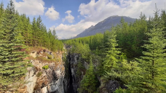
In the morning it still rained on & off but it felt really good to breathe fresh mountain air, so I was not fed up yet. 😅 Out of the 3 Rockies canyons (Johnston in Banff & Maligne in Jasper are the other two), I found my hike at Marble Canyon to be the prettiest, as the river has carved deep into the rocks, leaving a narrow chasm with the water way down below. Impossible to photograph its full length, the waterfall plunging down into the canyon is unbelievable! 😍 As a bonus, the sun even came out!


The other highlight of Kootenay park is the Paint Pots, ochre-red pools that were used by the Indigenous for e.g. body painting. I had a vague recollection that we were disappointed when we were here in 2010 and that got reconfirmed once I got to the 2-3 small pools... nothing special here but the hike to them was pretty enough not to make it a waste.

As the weather was flipflopping between rain & sunshine and I didn't want to get rained on another hike, I decided to spend the afternoon in Banff as there were still several things I was interested to explore & it would be fun to go for dinner in town... Banff was just 30 minutes away on the other side of the Continental Divide, which determines whether a rain droplet flows west to the Pacific Ocean or east to the Atlantic Ocean. Kinda cool to think how different those paths would be if you were to be a rain droplet! 😉
Am running out of my photo limit so next post will be about Banff (2nd visit) and Jasper!

Wildlife: 21 bighorn sheep (only 2 with actual big horns 😜) at Radium
SUPs: none
Hikes: 4 at Kootenay Park
Distance driven from last map: 1,631km
2 notes
·
View notes
Text
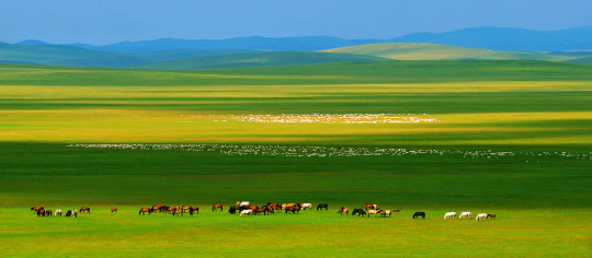
The Eight Great Grasslands Of "Hulunbuir" Hidden In Guangdong
Do you know? It turns out that you don't need to go to Inner Mongolia, you can see the big "grassland" in Guangdong. I thought Guangdong only had seaside vacations, but I didn't expect there to be beautiful prairie to check in. Today, I would like to recommend a few grasslands where you can check in and camp in Guangdong. Let's go, let's go to the prairie together. Go and experience the healing scene of "the wind blows the grass and sees the cattle and the sheep".
Shaoguan Luokeng Grassland
One of the top ten beautiful campsites in China is undoubtedly the small "Zhangjiajie" in Guangdong. Luokeng Grassland is a grassland surrounding the lake. The large grassland formed after the water level of the Luokeng Reservoir dropped is a small prairie. Here you can see a large starry sky, paddle boards, underground caves, submarines, and bonfire roast sheep. At the same time, it satisfies the three major playing methods of camping, water playing and caving. Address: Luokeng Town, Qujiang District, Shaoguan City, Guangdong Province
Yingde Tianmengou Grassland
Yingde Tianmengou is undoubtedly a scenic spot worthy of vigorous development. There are countless waterfalls, unique tree houses, and a rare alpine grassland in Guangdong--Bainiaotang Prairie. Here you can enjoy the wild, alpine camping, horseback riding and grazing. Flying a kite, walking and running, this is undoubtedly a paradise for wild camping. Address: Shimentai Nature Reserve, Babaoweizai Village, Shigutang Town, Yingde, Qingyuan City, Guangdong Province
Yangchun Chicken Coop Top Prairie
The chicken coop top prairie of "three cities with one foot" has the largest prairie in the south. It has a paradise-like beauty, natural grass skiing fields, golf courses, bright sunshine, negative air ions, and clear streams. In April and May every year, you can also see red rhododendrons all over the mountains and plains. Address: Qixing Village, Shuangjiao Town, Yangchun City, Yangjiang City, Guangdong Province
Xinxingtianlushan Prairie
The scenery here is different in four seasons. There are cold plums in winter, rhododendrons in spring, green hills in summer and terraced fields in autumn. From time to time, cattle and sheep pass by on the mountain, and azaleas bloom here every spring. There are also plum blossoms, sparrows, pomegranates, camellias and unknown wildflowers. Not only is the mountain towering, surrounded by clouds and mist, but also negative air ions, a natural oxygen bar. Address: Tianlu Mountain, Lidong Town, Xinxing County, Yunfu City, Guangdong Province
Renhua Wanshi Mountain Prairie
This is the prairie on the first peak of the three provinces of Guangdong, Jiangxi and Hunan. It belongs to the alpine valley grassland and stretches over 10,000 mu of alpine meadow in the three provinces. There are three province boundary markers on the top of the mountain, so you can visit three provinces. Here you can not only enjoy the snow in winter and spring, but also camp in summer and autumn. From the foot of the mountain to the top of the mountain, there are seas of clouds, grasslands and rhododendrons. Address: Wanshishan Grassland, Changjiang Town, Renhua County, Shaoguan City, Guangdong Province
Xinyi Tianma Mountain Grassland
The Tianma Mountain Prairie, known as Guangdong's "Shangri-La", is undoubtedly "the most beautiful rural tourist area in Guangdong". There is no severe heat in summer, no severe cold in winter, and the four seasons are like spring. Grasslands, forests, canyons, waterfalls, clear springs, and flowing water make this place slowly become a paradise. Here you can not only see the natural landscape full of wild interest, but also experience the unique Miao customs. Address: Wangjiang Village, Beijie Town, Xinyi City, Maoming City, Guangdong Province
Fenghuangxia Xunhuang Prairie
Fenghuangxia Xunhuang Prairie is undoubtedly a rare prairie in the south. Located in Phoenix Lake, it covers an area of hundreds of acres, surrounded by 138 green islands and vast grasslands. Inlaid in various poses and with different expressions in the center of the lake, forming a natural landscape painting. Address: Xunhuang Village, Fenghuang Gorge, Duanfen Town, Taishan City, Jiangmen City, Guangdong Province (Xunhuang Grassland Farm)
Luoding Bapai Mountain Grassland
The Bapai Mountain Grassland is located in the Bapai Mountain Scenic Area. The Bapai Mountain Scenic Area includes eight unique mountains, so it gets its name. The heavenly top of Bapai Mountain is a natural grassland, which is the Bapai Mountain Prairie. Grasslands, forests, rhododendrons, strange rocks, and clouds complement each other, making it ethereal and beautiful like a fairyland. It's like being in a paradise. Address: Bapai Mountain, Chuanbu Town, Luoding City, Yunfu City, Guangdong Province
Stepping on the grassland, the breeze rushes towards you, but what you see is the poetic, romantic and picturesque scenery. There is no city noise and car horns here. There are only cattle and sheep, the sound of birdsong, and the fragrance of flowers and grass. Pass through the vast grasslands and have a warm embrace with nature. Enjoy endless peace and comfort on the vast grassland, let the natural scenery and grassland beauty heal our restless hearts.
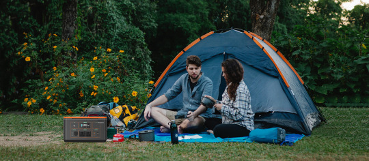
When camping on the grassland, you have to bring a camera, as well as simple picnic tools and camping equipment. And these equipments are big power consumers. There is no power supply on the grassland. At this time, there must be an outdoor power supply with unlimited battery life to power these devices. Here I recommend Powerfar outdoor power supply, one of the top ten domestic brands.
This power supply has a large capacity of 1065Wh, built-in 13 output ports such as 220V AC/QC3.0/DC/car charger. The continuous output power is 1000W, and the peak value can reach 2000W. This outdoor power supply can power ventilators, disinfection machines, drones, electric drills, small appliances, kettles, cameras, and computer equipment. It is suitable for scenarios such as long-distance self-driving, emergency assistance, geological survey, and vehicle power supply.
Don't worry about running out of power, it supports solar charging, and there is electricity when there is light. There is Powerfar outdoors, full of safety, full of battery, and freedom like home.

Bring all the above equipment, and then come to the grassland to be a "herdsman" for a few days.
Tips: Summer goes to autumn, so the temperature difference between day and night gradually increases. Friends who are going camping, please remember to prepare for the cold at night.
2 notes
·
View notes
Text
BOTR - Day 8 - June 22, 2024
In the middle of the night both Diane and I woke up to see moonlight shining on the trees trunks, giving them a white glow. I thought we had our headlights on, it was so bright. Diane went to explore the source and saw the moon very low on the horizon. We went back to sleep.
We both woke up before 6am. Nature called. Then we slept until 8am. It was luxurious! We could hear the stream rushing below our campsite and when we looked out our windows we saw filtered sunlight through the trees.

Creek below our campsite.
We didn’t waste time getting out of camp. We were rolling before 9:30 and, surprisingly, had the road to ourselves. After a series of steep climbs to over 9200’ in elevation, we descended into a gorgeous canyon. We drove switchbacks, quickly descending to the canyon floor. On both sides of us were shear sandstone cliffs and steep grassy pastures pocked with scrubby trees. A river ran down the middle.

Up and over the pass to Tensleep.

Pics do it no justice.

Looking for sheep and goats…
As we came out of the canyon we rolled into Tensleep, a tiny town with a population of 249. Today, however, the town swelled with tourists visiting most of the businesses.

Popular Tensleep establishment.
The next couple of hours of driving were over long straight roads through scrub land. The views varied from painted rock formations to eroding bluffs that looked like sandcastles.

Looking from WY into MT.
We stopped along the way in Powell, WY for a bite to eat and a little shopping for provisions. We enjoyed some homemade fare at the Skyline Cafe where everyone seemed to know each other. An hour later and we stopped in Red Lodge, MT. Definitely a higher-end tourist spot at the start of the Beartooth Highway.

Powell, WY.
Our campsite was 15 miles outside of Red Lodge at the start of the Beartooth Highway. We had a nice level spot next to Rock Creek. We had missed a bull moose that walked near the campground, by a couple hours. We would spend the next couple of days listening for it, hoping it would return.

View from camp.

More camp pics.
Dinner in camp was coho salmon with wild rice pilaf. A couple of beers later and we were sound asleep after a long day.
0 notes
Text
The Best Campgrounds Near Yucca Valley, California United.
Certainly! Here are some of the best campgrounds near Yucca Valley, California:
1. **Joshua Tree National Park:** Offering several campgrounds within its boundaries, Joshua Tree provides stunning desert landscapes, unique rock formations, and excellent stargazing opportunities. Popular campgrounds include Jumbo Rocks, Hidden Valley, and Black Rock. Click Here
2. **Joshua Tree Lake RV & Campground:** Located just south of Joshua Tree National Park, this campground offers RV and tent sites along with amenities such as a lake for fishing and swimming, hot showers, and a convenience store.
3. **Black Rock Canyon Campground:** Situated within Joshua Tree National Park, this campground offers a serene desert setting with spacious sites, flush toilets, and potable water. It's an excellent option for those seeking a quieter camping experience.
4. **Cottonwood Campground:** Another campground within Joshua Tree National Park, Cottonwood is located in the southern part of the park and provides access to hiking trails and scenic viewpoints. It offers tent and RV sites with basic amenities.
5. **Sheep Pass Campground:** Also located within Joshua Tree National Park, Sheep Pass Campground offers a more secluded camping experience, with fewer amenities but easy access to hiking trails and rock climbing areas.
6. **Pioneertown Campground:** This rustic campground is situated near the historic town of Pioneertown and offers tent camping and RV sites. It's a great option for those looking to explore both the desert and the unique charm of Pioneertown.
7. **J Tree Inn and RV Park:** Located in Joshua Tree, this campground offers RV sites with full hookups, as well as tent sites. It's conveniently located near restaurants, shops, and attractions in town.
8. **Indian Cove Campground:** Another campground within Joshua Tree National Park, Indian Cove offers stunning rock formations and easy access to hiking and rock climbing areas. It's known for its beautiful scenery and peaceful atmosphere.
These campgrounds provide a variety of options for camping enthusiasts near Yucca Valley, allowing visitors to immerse themselves in the beauty of the desert landscape while enjoying outdoor activities like hiking, rock climbing, and stargazing.
0 notes
Text
Etno Selo Katun, Žabljak, Montenegro - Durmitor National Park
Thursday 12th October
My original plan was to head across the border into Montenegro after the weekend, on Monday, but I’ve an eye on the weather forecast. This spell of hot and dry weather is unusual for the time of the year here, and is forecast to break on Monday, with more cloudy conditions with some rain moving in, and much cooler temperatures.
The Durmitor National Park has been high up on my agenda since I cycled through it 5 years ago. So I decided to cross the border today, have 4 cloudless days, before the weather changes. It is high up here, peaks at 2,300 - 2,500 metres, and the town below at almost 1600 metres, so there is the first snow of the winter in the forecast, and I expect the peaks may not be visible. My plan is though regardless, to be around the National Park for a week or so.
My other concern (of course) is to have a decent 4G signal for the quarter finals, but on that score, I needn’t have worried.
The campsite in Tjentiste was good. Last night I ate at the restaurant with a Swiss couple, and it was fine, and definitely cheap, at less than 10 euros for a couple of beers and dinner.
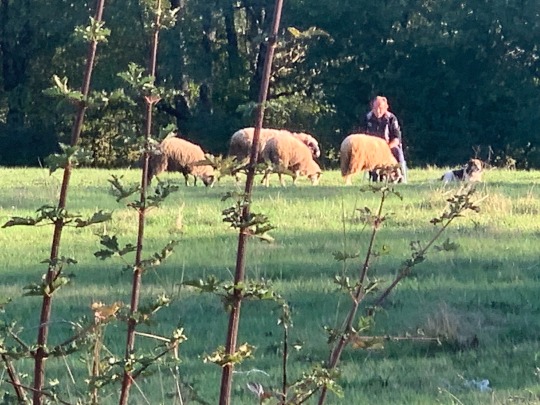
I had chance to admire the stress-free job of the guy in the next field, who from half an hour after first light, about 7:30 am, until dusk at 6:30 pm, watched his 4 sheep, along with his dog..
The road I took heads north to Foca, then cross the famous Drina river, and follows a tributary of it, the Tara, eastward. At Foca the Piva river meets the Tara river to become the Drina. The Tara canyon extends about 140 kilometres, and the first part of it, in Bosnia, is renowned for rafting. There are about 30 companies with campsites and cabins on the riverfront offering trips in season. In Montenegro there is some rafting also, but the sides of the gorge have now become vast and steep, and it is a popular tourist destination for the viewpoints alone.
The road along the river side, about 30 kilometres into Pluzine, goes through 56 tunnels, and though never wide, and quite rough, is a fantastic drive. I cycled it in the opposite direction 5 years ago, and in fact was in Pluzine for my 57th birthday, having descended the 1200 metres from Durmitor high above. This time, I headed up that road.
Include the 20 hairpins, with another 15 tunnels up the side of the Tara gorge, and two-thirds of this incredible route is complete, but arguably, the best is still to come, as the single track road heads across the mountains on the south side of the National Park over the pass at 1750 metres.
For the last few years, and obviously right now, this is my number one National Park, and pleasantly quiet, with a few other tourists, today.

I drove through the National Park, and on for another ten kilometres to the town of Žabljak where I stocked up at the supermarket for the weekend and picked up a SIM card. Montenegro offers tourists the deal of no less than 1 TerraByte of data for 30 days for 20 euros. There’s an unwritten challenge to see if anyone could actually use that much data.

Then I headed back into the Park, having seen a couple of places for potential stopovers, but they offered little shade, and the afternoon was hot, and the weekend forecast to be more so. I found a small farm, the last one before the Park begins, and called in to see what was offered. Here, a young family has just opened some old cabins, which in time they will fully renovate. They offer campervan spots also, with just basic facilities.
It’s an ‘eco’ theme, so all the power and water is heated by solar (the shower in the picture above). The highlight though, and the first stage of their renovation, is cafe / restaurant, which I headed up to for a beer in the evening. The food looks good also, so I will try that out in the next day or two, and again, it’s very cheap. The only other people here are a group of contractors working locally, and staying in the old cabins. They ask just 5 euros a night for staying over, and it seems perfect for the weekend, also, by chance, with super fast 4G at 60-70 MBps.
0 notes
Text
Teton Crest Trail
August 15-18
There is both a northern and a southern “Teton crest trail;” the northern crest is primarily in the Jedidiah Smith Wilderness, while the southern crest is in Grand Teton National Park. We spent 2 big days on the Northern Teton Crest Trail. It’s older trail, so it went steeply right up and down the passes. It was patchy trail, and in several places we lost the trail completely. But the views were absolutely incredible. We didn’t see anyone until the afternoon of the second day. They were locals who pasture their horses out in the national forest. They gave us a great restaurant recommendation for Jackson, but more on that later.
The two Teton Crest trails do not connect, so Owen had downloaded the GPS data from a previous thru-hiker who had bushwhacked a route between the trails. We set off on our bushwhack and it actually started out easier than a lot of the trail we had just done. But it gradually got more and more difficult, climbing steep slopes, rocks, etc. We stopped for a snack when we first got a view of the main three Tetons. Amazing! Only about 1.5 miles to go until we joined the southern Teton Crest Trail. But what a 1.5 it was! First we scrambled over a narrow, rocky ridge. Then we had to basically rock climb down 1200 feet in 0.6 miles. It is definitely the sketchiest thing we have done on trail. Luckily, we made it down safely and set up our tent overlooking Lake Solitude, just in time to shelter from a storm.
The following morning, we were blown away by the immaculate trail and breathtaking scenery on the southern Teton Crest trail. We saw a bull moose grazing right near the trail, then were delighted by waterfalls, mountains, and lush forest. Hurricane Pass was a gorgeous climb, aptly named for the wind. Owen was moved to tears by the beauty. We descended into Alaska Basin, met some Vermonters backpacking through, then climbed Sheep Steppe Pass to get to Death Canyon Shelf. From there, we took a side trail down into Death Canyon. We saw a cow moose and her calf eating dinner. We camped near a lake back down in the low country.
In the morning, we walked out to the road, where traffic was backed up because of a black bear hanging by the road and leisurely eating berries. The ranger and animal control officer waved us through when appropriate. We walked out to the visitor center and hitched into Jackson. A woman picked us up and brought us right to the post office, which was also conveniently near the REI (where I switched to hokas), and the Mexican restaurant that had been recommended to us. Let me tell you, that Mexican restaurant had the best food that we have had on trail! Owen got a giant torta, and I got a burrito with green chili cheese sauce. At the restaurant, Owen overheard two young boys talking about DND. He struck up a conversation, and the parents, Peter and Rachel, offered for us to stay in their backyard that night. When we got there, they actually let us stay in their camper, because it was raining. They gave us some beers, and we came inside to play DND with the boys. What a generous family! In the morning they even drove us back to the trail.
0 notes
Text
10 Breathtaking Canoe Trails for an Unforgettable Adventure
Finding isolation may be as simple as packing up a canoe, setting out and casting a line into the bush without having to wear a heavy pack or travel for ten kilometers. Everything you need for a canoe journey is in a boat with you, so you do not have to worry about trying to squeeze past others on a crowded route or carrying heavy water containers. You can end yourself falling in true love with canoeing after taking a few journeys.
10 Best Canoe Trails
This list is not comprehensive. These best canoe camping trips USA are a fantastic place to start, but there are just too many beautiful spots to paddle & not enough time.
Boundary Waters, USA
On the boundary of the Canadian province both of Ontario and the US state of Minnesota, you will find the first canoeing location in this list. It is a safeguarded wilderness region with excellent animal viewing opportunities, making it the perfect place to go canoeing! After one day of paddling, you may rest and unwind at one of the roughly 2,000 distinct camp sites in the wilderness region!
Buffalo National River
Over 130 miles of canoeing are available on the Buffalo National River in the Ozark Mountains of Arkansas, which is suited for both novice and experienced paddlers. Both tranquil and rougher waters may be found in the river. Given the correct weather and season, it is possible to paddle the whole river in around ten days. Plan your trip according to the season since during dry weather the water levels drop too low to properly paddle the whole river.
Northern Forest Canoe Trail
This kayaking adventure is not for timid. It takes about a month to travel the 740 miles of Northern Forest Canoe Trail that crosses both Canada and the United States. Huge lakes, rough rapids, tranquil streams, and the odd portage—a road for moving your canoe from a stream to the next—can all be seen along the trail.
Current River
A panorama of lush, southern woodlands and numerous caverns may be seen from Current River, which is situated in Missouri's Ozark Mountains. If you want to go kayaking while taking in the autumn foliage, Current River is truly a fantastic option. All abilities of paddlers may safely use the river, however it is important to note that the upper river has choppier water that is preferred by experienced paddlers. Even the most difficult rapids are not so dangerous, although occasionally dangerous situations might arise due to the river's powerful current.
Bois Brule River
The Bois Brule River is located in Brule River State Forest, which is 45 minutes by car from Duluth, Minnesota. The 44-mile river section is a well-liked spot for canoeing and passes through a range of environments, from bogs to the boreal woods. The river may be paddled lazily for the most part, although there are certain spots where the water gets choppy. For novices, the upper river always is suggested.
Everglades National Park
Paddlers have essentially limitless options in Florida's Everglades. 10,000 distinct islands, innumerable mangroves, and a maze of waterways may all be found in the Everglades. Setting a camp on one of these islands & exploring the nearby rivers is all it takes to paddle through the Everglades. Animals including herons, dolphins, alligators, & bears have all been spotted in the wild. This will be one amid the best adventure vacations in USA.
Green River
While the paddling here is not difficult, maintaining your focus on the water could be. Labyrinth Canyon & Stillwater Canyon are two of the 120 miles of the Green River that pass through deep, red gorges and provide views of amazing rock formations. If Labyrinth Canyon is your preferred route, start at the Green River State Park & finish around 50 miles later in Mineral Bottom. The canyon walls increase steeper as you float through them over the following several days, and during the evening you will see bighorn sheep. To go into the canyon, you must get a permission from the Bureau of Land Management.
Bowron Lakes
In the Canadian Rockies' Cariboo Mountains region, there are 72 miles of the connected rivers, lakes and portages. The canoe circuit of Bowron Provincial Park truly is well-known across the world (in fact, all three of the testimonials on the website of a local outfitter are from Europeans). The Bowron canoeing adventure includes backcountry campsites, an abundance of animals, mountains, woods, and deep, clear lakes. For the entire circuit, allow 7–10 days.
Gold Lake- The tranquilly you seek can be found at Gold Lake if you prefer a laid-back canoe or kayak journey. Gold Lake is one of California's top family campgrounds, and it is 9 miles southwest of the Graegale, California, amid the picturesque foothills of the Sierra. Gold Lake is a great place for the entire family to have fun because there are 20 smaller lakes close by and a variety of recreational opportunities.
Wekiva Island
Wekiva Island though is not an island in the true sense,it does provides a relaxed haven both for friends & families alike in search for a place to gather along Wekiva River. The Wekiva Island located in Central Florida gives water lovers assorted family-friendly activities all along the beautiful Wekiva River. Should you desire in exploring this 16-mile river through your own paddles, then carry your own, else you may hire a kayak or canoe from the oasis too.
Canoeing is an excellent means of fitness and outdoor recreation for people of every age & skill level. Where will you be paddling next among the tens of thousands of best canoe trips USA that exist across the country?
0 notes
Text
The Ballad of Jack’s Bovine
In a magical version of America called Columbia, where fairytale tropes are accepted ways of life, show cow Bertha lives with Jack and his mother on the Trotter farm. However, after a wanted cattle rustler named Songbird Stark steals all the rest of the cattle, leaving only Bertha, the Trotters have no choice but to sell her. Jack runs into a mysterious man, Bardo Highmore, on the way into town and trades Bertha for a handful of "magic" beans. While Jack returns home to show his mother, Bertha is taken to Highmore’s home, where, revealing that he is a wizard, he transforms her into a human to help around the house. Tired of working, Bertha escapes, learning from a flock of sheep of a town called Proudgulch. Seeing no other options, Bertha heads out into the desert, where she encounters a cattle drive. Songbird Stark arrives with his henchmen, the Hopalongs, and before Bertha can attack him, he begins a song which sends all the cattle (including Bertha) into a trance that causes them to dance madly and follow him anywhere. A rancher, Shiloh Osborne, manages to subdue Bertha just before Stark closes the path behind him with a rock slide to stop anyone from following. The ranchers take Bertha to Proudgulch, where the mayor, upon learning of Bertha’s true nature, demands that she try to capture Stark. Bertha organizes a posse, consisting of herself, Shiloh, Elmer Ryan, Fern Grant, Dusty Dan Gill, Grover McGee and Bud Nielsen. However, the posse loses the trail in a flash flood, and spends the night under a large rock. The next morning, however, they are awakened by a jackalope named Bolt, who has also lost his home, an old mine, to Songbird Stark; Bolt agrees to guide them there. At the mine, Stark is planning to have a wizard named Lazar Periculum to turn the steers human, before using them as workmen to build a giant war machine, the Gargantia, using stolen blueprints; He intends to invade Washington and become President in a coup d'etat. The posse infiltrates the hideout, but Bertha, Shiloh and Grover are caught. However, the others manage to trap Stark, and all run off with the Hopalongs and Periculum in pursuit. When the chase stops, Periculum, recognizing Bertha as a transformed cow, reverts her to her true shape, though she retains the ability to speak. The others are taken hostage as Stark heads to Washington in the finished Gargantia. With Bolt’s help, Bertha manages to escape and free the others. In Washington, Stark demands that the President accept his terms of surrender, but the President rejects his ultimatum, and Stark retaliates by attacking a small town. The group frees the transformed cattle and battles Periculum and the Hopalongs before confronting Stark. Dusty Dan shoots Stark’s prosthetic leg, allowing the group to gain the upper hand, muzzling him in order to prevent him from singing the cattle into submission. As the Gargantia approaches a cliff, Stark shoots at Bertha with a concealed gun, but instead hits the Gargantia’s machinery, halting the Gargantia abruptly at the canyon's edge. Both Shiloh and Stark fall from the spider, but Shiloh is saved by Bertha. The Gargantia begins to fall into the canyon, forcing everyone aboard to evacuate before it plummets to the ground and is destroyed. As Periculum is forced to restore all the cattle to their true forms, the President offers to promote the heroes as the first agents of his new Secret Service, but they decline and return to Proudgulch by train. A few weeks pass, and at the county fair, Jack, having returned from his own adventure, arrives searching for Bertha, who has won a prize. Upon seeing that she is happy living in Proudgulch, he leaves her to her new life.
#original story#fantasy#Inspired by Home on the Range Rango Wild Wild West and other comedy westerns#This story was conceived when I thought of the cow from Jack and the Beanstalk#I wanted to explain what happened to her after she's sold
0 notes
Text
Horseshoe Bend Rafting Experience
If you are visiting Arizona and have no idea where to go, the city of Page, AZ is a great place to start. It is a small town located in the northern part of Arizona and is close to the beautiful Lake Powell. The famous Lake Powell was named after John Wesley Powell, an American explorer, ethnologist, and geologist.
Lake Powell is one of the city's most popular tourist spots in the Colorado River, where you can enjoy several activities for the whole family. It is a man-made water reservoir that was a product of the flooding of Glen Canyon that was caused by the Glen Canyon Dam. This is also the reason why Glen Canyon National Recreation Area was created.
Rafting trips are the most common activities when you visit this city. Some of the exciting rafting trips to try are Glen Canyons float trips, Colorado River rafting, and the famous Horseshoe Bend rafting trip. Any of these rafting trips will surely give you the best wilderness river adventures you"ll ever experience.
If you are not into rafting trips, you can do other activities like hiking. You even get the chance to see real-life great blue herons and bighorn sheep. A tour guide will assist you on the right way to follow during the hike and will even tell stories about the place like the mining culture, the ancestors' way of life, the history of the great Glen Canyon Damn, and the Petroglyph Beach.
youtube
youtube
Exploring the Colorado River
This magnificent body of water is 1, 450 mile long and surrounds some parts of the seven states in the U.S. and two other Mexican states. It is famous for its great canyons and magnificent rapids. By exploring the Colorado River alone, you will get to experience several breathtaking canyons like the famous Grand Canyon, Marble Canyon, and Glen Canyon.
Aside from the stunning sights at the Colorado River, your guide will show the amazing and ancient houses of canyon dwellers from thousands of years ago. One day is not enough to explore everything you need to see around the Colorado River, so be sure to take a few more days off from work to maximize your vacation.
Other astonishing places that you can enjoy at Page, AZ are the following:
Horseshoe Bend
Glen Canyon Recreation Area
Grand Canyon National Park
Petroglyph Beach
Lees Ferry
Vermillion Cliffs
Activities to Try:
Sightseeing at Glen Canyon Dam
Learning the Glen Canyon Dam history
Glen Canyon Float Trips
Aerial sightseeing
Half-day Horseshoe Bend rafting experience
A cool dip at the Petroglyph Beach
Camping and Hiking
Wilderness river adventure
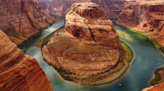
Horseshoe Bend Rafting Trip
Whatever it takes, you need to experience the Horseshoe Bend rafting, whether it is a whole day trip or a half-day rafting trip. Horseshoe Bend is a sight on its own. Its almost perfect circular canyon lets people admire its clear blue-green water.
Horseshoe Bend can be crowded with lots of tourists but if you want to avoid large crowds, you can always avail yourself of their airplane tour. Nothing beats the view of Horseshoe Bend and Lake Powell from the top, however, your trip will not be complete without seeing a complete Horseshoe Bend rafting trip.
Half-day is enough for a Horseshoe Bend rafting experience. There are several resorts and other travel and tour companies that offer tours for your rafting trips. You only need to allot at least half of your day to Horseshoe Bend rafting. So what can you expect when you avail one of these half-day rafting trip?
The usual rafting trip normally starts with a two-mile tunnel drive. Within this tunnel drive, you get to experience dinosaur tracks before boarding your river raft. Your wilderness river adventures start here as you enjoy the sights of Petroglyph Beach and the captivating artifacts.
After your wilderness river adventures from your river craft, you will then transfer to a motor coach ride. By this time, you are already at Lees Ferry going back to Page, AZ. During your motor coach ride, along the way, you will pass by Lees Ferry, sandstone walls, and other historic landmarks and structures.
After your half-day Horseshoe Bend adventure, be sure to maximize your trip while you are still in Page, AZ.
River Raft Safety Tips
If it is your first time trying river rafting, it is best to know the safety guidelines before doing it. Here are some safety tips before you go on your river raft adventure:
Always wear a life jacket even if you know how to swim.
Learn how to hold the paddle the right way.
Always listen and follow your guide.
Be attentive during the safety talk and take note of the commands.
Do not panic.
Learn the different swimming techniques.
Wear proper attire.
Horseshoe Bend Rafting Policy
Before you avail of your wilderness river adventures at Horseshoe Bend, be sure to take note of the policies that come with it. This is to avoid any unnecessary hassles during your raft trip.
Some of the things you need to check out are the payment, cancellations, pricing or rates, minimum passenger, pet policy, trip schedule, and other pertinent information that you need for the trip.
Once you have booked your half-day Horseshoe Bend rafting trip, be sure to be there to avoid paying any cancellation fee, if there's any. The Canyon National Recreation has the right not to fully refund for no-shows and late cancellations.
Under the guidelines of the National Park Service, there may be additional guidelines or policies due to Covid. So best to check first to see if there are any updates or changes that you need to know.
Important Reminders
Call river headquarters first and check their schedule before visiting.
Only backpacks or small bags are allowed during your rafting trips.
Weapons of any kind are strictly prohibited, even cigarette lighters and utility tools.
Do not forget to bring your camera to capture the beauty of the place
Wear proper attire
Bring sunblock and extra set of clothing
Best to bring food, water, and other drinks
Always treat people with respect
Follow health and safety guidelines
Follow the check-in and check-out time, rates, pet policy, and age restrictions
Always check in with your team or companion before and after raft trips
Due to Covid, follow safety protocols and bring your own sanitary kits and mask
Observe proper physical distancing
Final Thoughts
Horseshoe Bend in Page, AZ is truly a place worth visiting. The good thing too is that a half-day rafting trip is enough to experience it. This means you still have a lot of time to explore other interesting sights nearby. You still have ample time to check out the Glen Canyon Dam and try the Glen Canyon float trips.
Traverse Grand Canyon from Lees Ferry through a raft trip. In, addition to this, be sure to also drop by at the Canyon National Recreation Area or river headquarters for updates or other information like rates, check-in times, Grand Canyon, and Glen Canyon tours, accommodations, and other activities you can experience in the Colorado River.
If you are planning to spend a couple of days in the area, book ahead of time to find the best hotel and accommodation during your trip. Just be mindful of the check-in times for a smoother and hassle-free trip.
Now, go and treat yourself and the whole family to a one-of-a-kind wilderness river adventures you will all never forget. All thanks to National Park Service for taking good care of these special places so that people can enjoy and experience the American heritage. Don't forget to bring your cameras so you can capture and treasure your fun memories.
Frequently Asked Questions
Is Horseshoe Bend worth visiting?
Yes, it is a must-see place to visit. It is one of the top tourist destinations not only in Glen Canyon Recreation Area but in the whole city of Page, AZ.
How deep is the water at Horseshoe Bend?
It is roughly 1,000 ft. deep.
How long does it take to kayak Horseshoe Bend?
It may take you around 6-7 hours of paddling to complete the whole stretch of Horseshoe Bend.
How long does it take to walk to Horseshoe Bend?
It usually takes about an hour to hike Horseshoe Bend Trail.
When is the best time for a Horseshoe Bend rafting experience?
The best time to do the Horseshoe Bend rafting trip is between midday to early afternoon.
Is one day enough for a trip in Glen Canyon Float Trips?
You can spend a half-day float trip at Glen Canyon National Recreation.
Is there a park entrance fee?
Yes, you need to pay a certain park entrance fee. Rates vary.
Is there any person processing fee?
It may depend on the tour company's policy if you availed one.
Where can I get additional information about Horseshoe Bend and their wilderness river advantures?
You can call the river headquarters or check online for more information.
0 notes
Text
YELLOWSTONE 2: Our Sacred Earth (Expedition #61)
GUIDES: Joe Hetzer
ACTIVITIES: In order to preserve the uniqueness of this experience, to minimize impacts to habitat and wildlife—to “keep Yellowstone wild”—specific locations of hikes and activities will only be given to the finalized roster and will not be listed here. Students and participants will be expected to avoid tagging locations of activities on social media as well.
With Jackson Hole as our home base for the first three nights, this includes: a late-night campfire in a remote, magnificently picturesque location. It also includes self-exploration hikes and group hikes above tree-line to a summit. Upon that summit, students will have a view of the Greater Yellowstone Ecosystem that belies words.
Throughout this expedition, students will be on wildlife drives everyday where encounters and sightings of grizzly and black bear, moose, elk, big horn sheep, bison, mule deer are less-than-a moment’s notice of possibility.
Two days in Yellowstone National Park, the world’s first national park, to see geysers, mud volcanoes, majestic lakes, the Grand Canyon of the Yellowstone, and the famous wildlife havens of Hayden Valley and Lamar Valley.
Three days in Cody, Wyoming to experience the World Famous Cody Nightly Rodeo and to hike in the wildest country of the contiguous United States, including the Northwest corner of Yellowstone NP, Beartooth Pass, and the North Absaroka/Beartooth Wilderness.
Spanning Idaho, Montana and Wyoming, this is an intimate experience of wildness that transcends the tourist experience. It is here that students can see the night sky like never before while warming themselves by campfire and sharing in stories.
The expedition concludes with a return to Jackson Hole for three nights to include an additional late-night campfire and opportunities to ride trails on horseback or swim in glacial lakes. The expedition concludes with a whitewater rafting experience down the Snake River Canyon.
FACULTY: Marcus Mescher; Esmerala Nastase, PhD, Rita Rozzi
COURSES: 6 Total CORE Credits (9 Credits Possible, Students must choose 2 of 3 courses, but can enroll in all 3 courses).
THEO 388 (Mescher), 3 Credits, CORE THEO 200 Perspectives, ERS, Enviro Sci/Studies, Humanities Elective, Peace Studies, Free Elective
MATH 125 (Nastase), 3 Credits, CORE Math Perspectives, Free Elective, a unique way to receive credit in math principles in understanding geology, wolf pack behavior, and a host of other options.
ENGL 205 (Rozzi), 3 Credits, CORE ENGL 205, ERS, Humanities Elective, Free Elective
PROGRAM FEE: $2,590 includes roundtrip airfare, all lodging, ground transportation, wildlife drives, campfire experiences, Yellowstone and Grand Teton Park permits, whitewater rafting, meals, snacks, beverages.
TUITION: $535/Credit Hour, 6 Total Credits (separate from Program Fee)
DEPOSIT: $400 Nonrefundable deposit secures student’s spot. Deposit deducted from Program Fee.
LIMIT: Maximum 14 Students
VALUE: Attempting this program on one’s own would cost ~$7,540/person. For THIS expedition, a student’s total cost is $2,590 (Program Fee) + $3,210 (6 Credits Tuition) = $5,800 total. For questions on payment plans, contact Xavier University’s Office of the Bursar. For questions on grants and scholarships, contact Xavier University’s Office of Financial Aid.
0 notes
Text
Eorubeta: A Mysterious Ancient Frog Revealed
By Amy Henrici
I recently completed a project on fossil frogs from east central Nevada that my collaborators and I identified as the enigmatic Eorubeta nevadensis Hecht, a species that was originally based on a single, poorly preserved specimen that had been discovered in a well core.
The new collection of Eorubeta came from the Sheep Pass Canyon area about 12.5 miles northeast of the well core site. Peter Druschke discovered fossil frogs here in 2005 while working on his PhD dissertation on a rock unit known as the Sheep Pass Formation. Peter and fellow University of Nevada Las Vegas graduate students Josh Bonde and Aubrey Shirk and colleagues Dick Hilton and Tina Campbell (of Sierra College in Rocklin, California) collected additional fossil frogs in subsequent years. I was very fortunate to be invited to join the team, and we collected over 60 specimens for Carnegie Museum of Natural History in 2012, 2013, and 2016.
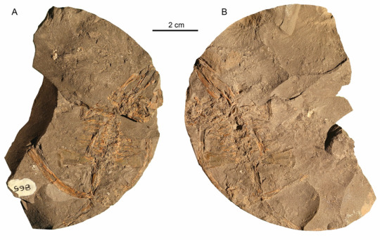
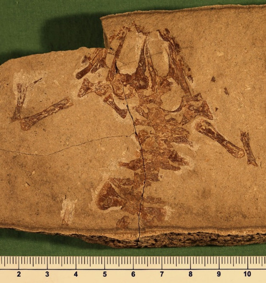
Part (A) and counterpart (B) of the first-known specimen of the fossil frog Eorubeta nevadensis. This specimen resides in the Vertebrate Paleontology collection of the American Museum of Natural History in New York.
The field site lies in the South Egan Range Wilderness Area of east central Nevada. Being a wilderness area, we could only drive on existing roads, and had to hike nearly a mile to the fossil-producing slopes. The climate in Nevada is challenging to work and camp in, with temperatures reaching over 100 degrees Fahrenheit during the July 2013 field season and nighttime temperatures dipping into the high 20s during the November 2016 season.
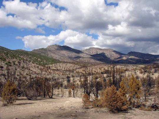
Road into the South Egan Range Wilderness area, White Pine County, Nevada. The area burned three months prior to the 2012 field season. The fire cleared vegetation from the fossil-producing slopes, making it easier to find fossils, though burnt tree branches left us streaked with charcoal.
When Eorubeta was originally named, the rock unit from which this frog came (Member B of the Sheep Pass Formation) was thought to date to a time interval known as the Early Eocene (56–47.8 million years ago). More recently, however, Peter has determined that this unit was probably latest Cretaceous–Paleocene (72.1–56 million years ago) in age instead. It is thus possible that Eorubeta spanned the Cretaceous–Paleogene boundary (66 million years ago) and survived the infamous asteroid impact that caused the extinction of non-avian dinosaurs and many other animal and plant species.
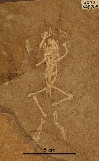
Two of the recently-collected specimens of Eorubeta nevadensis.
Peter determined that the beds in which the fossil frogs were preserved were part of a very high-elevation lake system (1.4–2.2 miles in elevation), similar in this way to today’s Lake Titicaca located in the Andes Mountains on the border of Bolivia and Peru. To date, Eorubeta is the only fossil frog known to have inhabited such a high-elevation environment. Most fossil frogs from this time come from prehistoric river and lake systems situated on coastal plains. The discovery of Eorubetasuggests that ancient frogs probably inhabited a greater variety of environments than the current fossil frog record indicates.
The first specimen discovered by Peter in 2005 indicates that Eorubetamay have reached a considerable size, though the fossil’s extremely weathered condition makes its identification uncertain. An analysis of the relationships of Eorubeta to other frogs reveals that it is more archaic than spadefoot toads, Neobatrachia (a group known as modern frogs), and their relatives.
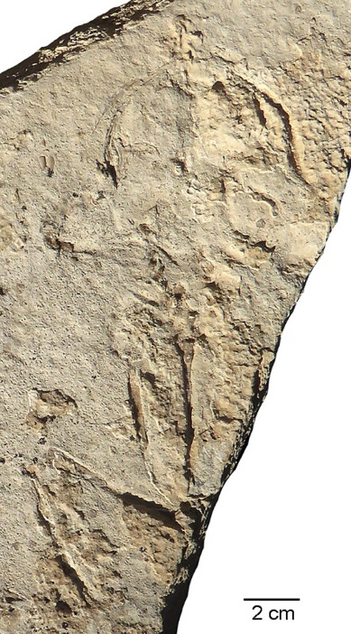
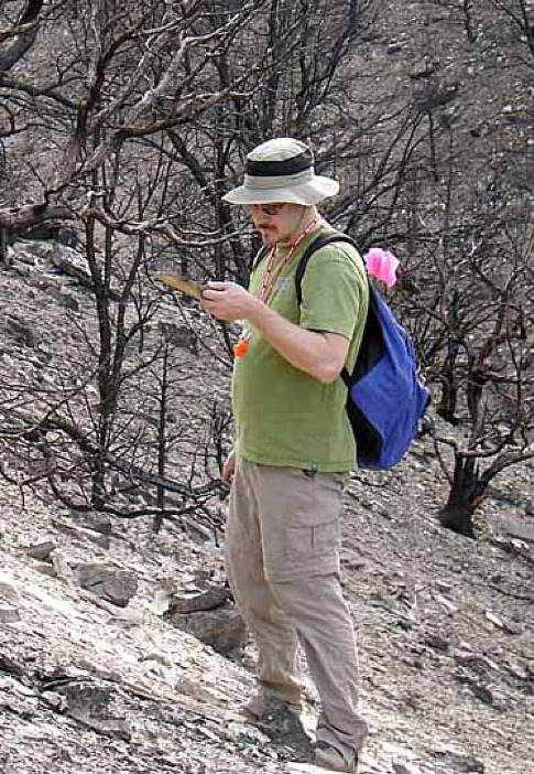
Top: the largest known specimen of Eorubeta. Bottom: Peter Druschke, the team geologist who discovered the specimen.
To learn more about Eorubeta, please follow this link to our paper recently published online in the Journal of Vertebrate Paleontology: https://www.tandfonline.com/doi/full/10.1080/02724634.2018.1510413.
Amy Henrici is the collection manager for the Section of Vertebrate Paleontology at Carnegie Museum of Natural History. Museum employees are encouraged to blog about their unique experiences and knowledge gained from working at the museum.
#Carnegie Museum of Natural History#Eorubeta#Paleontology#Vertebrate Paleontology#Sheep Pass Canyon#Frog#Ancient Frog
13 notes
·
View notes
Last Seen Blogs