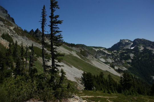
#Tatoosh Range
Text

Tatoosh Range, Mt. Rainier National Park, Washington, USA by Chris Moore
#tatoosh range#mt. rainier#mount rainier#mount#nature#landscape#sunlight#flowers#wild flowers#nature aesthetic#petitworld favs#petitworld
3K notes
·
View notes
Text
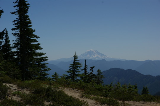
Wandering around the backside of the Tatoosh Range - MRNP
426 notes
·
View notes
Text
Mountain Memories: Pinnacle Peak Climb
Another popular guided activity during the 1920s-30s was climbing Pinnacle Peak in the Tatoosh Range. It took around six to eight hours round trip leaving from the Paradise Valley and cost $4 per person in 1920, including clothing rental. The Pinnacle Peak Trail continues to be a popular route to this day.
Mount Rainier National Park Archives Footage (mora_25027; excerpt of “Rainier National Park in the Heart of the Pacific Northwest”). No audio. Available with audio description at https://go.nps.gov/MMem-PinnaclePeakClimb. ~kl
#mountain memories#mount rainier national park#Mount rainier#Tatoosh Range#Pinnacle Peak Trail#Pinnacle Peak#black and white film#archives#history#historic footage
36 notes
·
View notes
Text


The Tatoosh Range, taken from the official Mt. Rainier website. I like to stop in occasionally and see the views I'm missing.
#mt. rainier#mt. rainier national park#tatoosh range#not my pics#check it out for yourself sometime#as long as the weather permits though
2 notes
·
View notes
Text

Five pictures were added to developingnaturegallery.com to begin the creation of the Mount Rainier folder. Kimberly used to live near this National Park and so, she will be adding a few pictures of the volcano, waterfalls, mountain peaks and wildlife images that she created inside the park here/there over the coming years.
If you're getting snow this weekend, stay safe.
Have a great weekend everyone!
#landscapes#waterfalls#mountains#volcano#national park#washington state#blue sky#clouds#trees#summer#travel#mount rainier#tatoosh range#pearl falls#sluiskin falls#maple falls#pyramid peak#kimberlyjt#giftideas#shoponline#developingnature#women photographers#artists on tumblr#shopsmall#art#photography#nature#wall art#decor#mugs
0 notes
Text

size: 32x24in Photographic Print: Washington State, Mount Rainier National Park, Tatoosh Range and Wildflowers by Jamie & Judy Wild :
9 notes
·
View notes
Text

After a great day of poking around the trails as we entered the park through the Stevens Canyon entrance- I got in 5 1/2 miles and Ben about 6 1/2/we checked into our room at the Paradise Inn, a National Park lodge, cracked open some bubbly, opened up some Gruyère and enjoyed happy hour with a view of the Tatoosh range. Cold mountain air with that awesome alpine smell of lichen and Douglas firs pouring in through the window. Are we in Switzerland or Washington? You be the judge.
0 notes
Text


SEPTEMBER 14, 2021, REFLECTION LAKES, PINNACLE PEAK, TATOOSH RANGE
0 notes
Text

Low Fade - by Ryan Dyar
Here’s an excerpt from Wikipedia about how the Tatoosh Range (pictured here) was named: “Tatoosh means "breast" in the Chinook Jargon,[2] in reference to the two large rock outcrops on the south face of Butter Peak.“ So this is basically the Boob Mountain Range.
While these mountains aren’t huge, and as a matter of fact are quite small, they are still wonderful. I think most folks don’t discriminate about how big or small they are… mountains of any size are pretty awesome to see. However, if you’re inclined to not be too interested in Tatooshes, I can always post a desert pic of a large sandstone monolith named Long Dong Silver (I’m 100% serious). I try to cater to everyone’s preferences.
I’m as mature as I was when I was 13 years old.
As always, thanks for scrolling far enough to see my dumb little picture. If you are interested in learning how I create my dumb little pictures, reading my dumb stories or seeing more dumb photography, you can head to www.ryandyar.com or check out the link in my profile. Email subscribers get free video tutorials monthly. ❤️
#floral photography#floral enrichment#floral#flowers#floral odyssey#the floral odyssey#wild flowers#nature#wildflowers
0 notes
Photo

...
marlonholden
1K notes
·
View notes
Photo

The end of an agonizing climb up the Fuhrer’s Finger on Mt. Rainier.
Washington
1968
#vintage camping#campfire light#mt rainer national park#mt rainier#1960s#washington#climbing#hiking#adventure#exploring#tatoosh range#love
203 notes
·
View notes
Text

Tatoosh Range, Mt. Rainier National Park, Washington, USA by Jesse Estes
#mt. rainier#mount rainier#mount#landscape#wild flowers#purple sky#nature#beautiful#flowers#usa#washington#nature aesthetic#petitworld favs#petitworld
3K notes
·
View notes
Photo

Fading light - Mt. Rainier National Park
#mt. rainier national park#tatoosh range#mountain scenery#golden hour#trees#cascade range#washington state#pnw#pacific northwest#upperleftusa
351 notes
·
View notes
Text
“Wear sunscreen.
If I could offer you only one tip for the future, sunscreen would be it.” – Mary Schmich
As you pack your backpack and motor vehicle before heading out to the mountain, one thing to consider is sun protection.
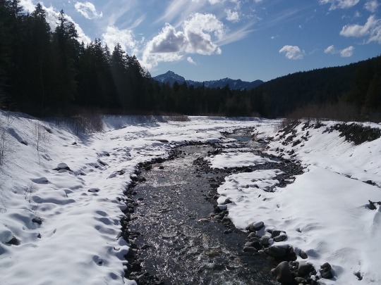
Yes, it’s winter. The Pacific Northwest is known for its rainy, cloudy, foggy weather in the winter. That can be very true in the lowlands around the Puget Sound. But as you drive up into the mountains it can be a very different story.
Sometimes you drive up to Longmire and Paradise and you end up above the clouds. We can get a few winter inversions where it sets up sunnier up high then down near the Sound.
Paradise is also at a higher elevation, 5,420 feet above sea level. Your skin can be exposed to more solar radiation up here.
And one more thing, snow. Snow can be a great reflector of the sunshine.
So please, bring some sun protection. Sun screen, hats, sunglasses can be good options for protecting your eyes and skin.
What are some of your favorite sun protection options?
Is there something that you’ve found works great when you’ve spent a sunny day at Paradise?

Information on the 10 Essentials can be found on this website https://www.nps.gov/articles/10essentials.htm Park information on winter safety can be found here https://www.nps.gov/mora/planyourvisit/winter-safety.htm
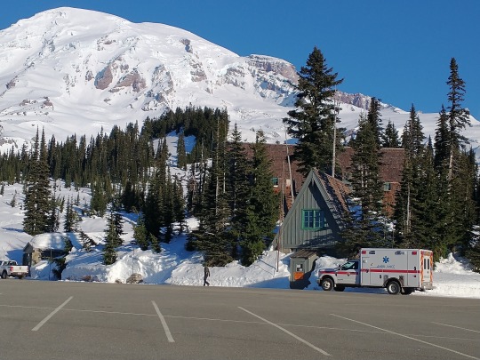
These photos are from years past and do not reflect current conditions. NPS Photo. View looking down the Nisqually River from the Longmire Suspension bridge with snow covering the rocks and banks. Evergreens line the banks and Sawtooth Ridge is in the background. A few clouds in a bright blue sky. February, 2020. NPS Photo. Looking up across the upper parking lot at Paradise towards the Old Station, and Guide House. Snow covers the meadows and Mount Rainier in the background. January, 2022. NPS Photo. Snow covered meadows in Edith Basin with snowshoe tracks leading away. Tatoosh Mountain Range in background with bright blue sky.
35 notes
·
View notes
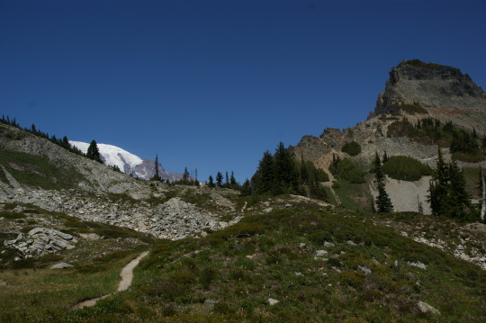
Video

flickr
Pinnacle Peak and The Castle (Mount Rainier National Park) by Mark Stevens
Via Flickr:
A view from a roadside pulloff just down the road from Narada Falls on Paradise Rd. Here I wanted to bring the image in closer to some of the peaks of the Tatoosh Range in the Mount Rainier Area. By focusing on the jagged peaks of The Castle and Pinnacle Peak, I felt it might bring a person seeing this image to a typical setting in Mount Rainier National Park. One could start nearby with the evergreen trees going up the hillside and then take in the jagged peaks and finally be drawn to the blue skies with white puffy clouds.
#Capture NX2 Edited#Cascade Range#Color Efex Pro#Day 3#Evergreen Trees#Evergreens#Looking SE#Mount Rainier Area#Mount Rainier National Park#Mountains#Mountains in Distance#Mountains off in Distance#Nature#Nikon D800E#Pacific Ranges#Pinnacle Peak#Project365#South Washington Cascades#Tatoosh Range#The Castle#Trees#Trip to Mount Rainier and Columbia River Gorge#WA#United States
4 notes
·
View notes
Photo


front:
Tatoosh Range from Paradise Valley Rainier National Park
Indian Basket Grass in Foreground.
back:
Pacific Novelty Co. San Franisco & Los Angeles
#pacific novelty co#postcard#postcards#postcards from washington#washington#washington state#Tatoosh Mountains#tatoosh range#paradise valley#rainier#mt rainier#national forest#national parks
58 notes
·
View notes
Last Seen Blogs

agenfiforlifboyke-blog
Agen Fiforlif WA 0812-2764-6849


ehmgem
The Gem That Is Ehm

mortuaryprince
prince

ranger-underscore
ranger_