#Youghiogheny Valley
Text
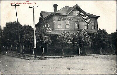
East McKeesport
East McKeesport
East McKeesport, a small borough in Allegheny County, Pennsylvania, boasts a rich heritage tracing back to the pioneering McKee family. Situated on a scenic plateau among the Turtle Creek, Monongahela, and Youghiogheny Valleys, it presents an altitude that offers unique perspectives on the region.
With its incorporation dating back to December 1895, East McKeesport, PA,…
View On WordPress
#East Mckeesport#East Mckeesport News#East Mckeesport Pennsylvania#East Mckeesport Police#East Mckeesport Post Office#East Mckeesport Weather#East Mckeesport Zip Code#Is East Mckeesport A Good Area#Where Is Mckeesport Pa Located
0 notes
Text
Ohiopyle, Pennsylvania circa early 1970'S
(just in time for end of summer reading...
recounting emotionally disastrous campy turbulence)
intended food for thought indulgence.
A boys' life aborted
miscarried golden opportunity
for adolescent romance to be courted.
Amidst a raft of fellow (Brandywine Valley
Y.M.C.A) resident campers
seething with hormonal secretion to canoodle
who, didst excitedly quiver
donning a "NON FAKE" lifejacket
coursing down swiftly
moving Youghiogheny river
(evidenced by small hairs along spine),
that caused me animatedly to shiver
snuffing out potential fortitude
gained late in mein kampf,
whereat yours truly a creaky giver
even scores of years later deliver
to sender nowhere to be found.
This predisposition prevailed despite
punishing revenge didst stamp excite
me inducing suppressed
giddiness to take flight
against self toward parents,
whose puny singular offspring
smallish in stature of height
who did light,
a conspiratorial idea
countered meek self spite
compared to their hefty might
forced me to attend ("dumb")
sleep away camp
for about a fortnight
whereupon, being dropped off "bright"
brainchild idea awoke around edge
of night bordering my consciousness,
where figurative dark shadows
courtesy Molly Hatchet cleft a wedge
vis a vis, an immediate
avowed personal pledge
sworn against experiencing even
one iota of fun (a ha...so there) ledge
er domain mental prestidigitation
could not dredge
countervailing loathsomeness naysaying fun
in any weigh, shape or form
pertaining to this sole son
but, matter of fact
adventuresome giddiness gave run
for metaphorical psychological money,
and much to my chagrin
gleefulness didst stun
into silence malevolent
anti yippee surge
crept into the noggin of this
chaim yankel and could not purge
this meta static Grinch,
who could not steal away
euphoria that inevitably didst emerge
unable to root out,
and suppress nemesis
flitting hither and yon to and fro
fomenting misery, but an inescapable glow
manifested when father
and mother end of Jeff session
came back, and said "hello"
when, and I immediately
replied with emphatic "NO"
in regard to having a good time oh
mitt ting like a lump pin pro
let tarry yet exerting will
power to asphyxiate
a faint bubbling of attraction
toward a darker skinned
slender cute teen age girl
though at that stage
oblivious how to create
friendship, thus aye
vividly recall to this date
hopscotched potential summer romance
which induces regret to emanate
cursing forsaken ill fate
now, feel deplorable
for stifling relationship
slid into behavioral sink (of this got
ham) fore'r tortured
within iron barred heaven's gate.
0 notes
Text
cheat river mod menu 0MVR%
💾 ►►► DOWNLOAD FILE 🔥🔥🔥🔥🔥
The Cheat River is a mile-long tributary of the Monongahela River in eastern West Virginia and southwestern Pennsylvania in the United States. Via the Ohio River, the Cheat and Monongahela are part of the Mississippi River watershed. The magnificent Cheat River flows from five major tributaries, known as the “Forks of the Cheat”, which originate in the rugged Monongahela National Forest. Located in Albright, in North Central West Virginia, the Cheat Canyon section of the Cheat River is West Virginia's premier springtime Class V whitewater run. The Cheat River is amazing! This river canyon is full of great rapids and we loved the guides on our trip. I can't stress how important it is to go with. The Cheat River in West Virginia is again a haven for whitewater rafting and smallmouth bass fishing after years of Clean Water Act funding. The Shavers Fork is acknowledged as the starting point of the Cheat River and emanates from the crest of Cheat Mountain at 4, ft, making it the highest river in the Eastern US. From Parsons, the scenic Cheat flows nearly 78 miles past the historic river towns of St. The Cheat River flows north throughout its entire length. The complete watershed spans an impressive square miles, and the river is one of the longest un-dammed waterways in the eastern United States. It does not appear that there were significant permanent native american villages in the Cheat River drainage, this is probably due to the steepness of the terrain and the harshness of winters. European settlers and trappers roamed the basin starting in The famous cornerstone, The Fairfax Stone, was placed in indicating the divide between the headwaters of the Potomac River and the Cheat River. The Dunkards, a religious sect, were the first Europeans to settle on the Cheat River, in , they established a village where present day Camp Dawson is located near Kingwood, WV. This combination of resources led to the creation of some of the earliest iron industry in the US contributing greatly to the armaments of the war of , cannonballs made along the Cheat River were used in the Battle of New Orleans. The iron industry along the lower reach of the river supported roughly 3, settlers, with the epicenter being at Cheat Neck, the site of current day Cheat Lake, a few miles above the confluence with the Monongahela. The Cheat River watershed is considered a biodiversity hotspot, a portion of it became a West Virginia Natural Area in In fact, land use within the watershed is dominated by forest, at a stunning More than ten endangered, threatened, or globally rare species occur in the Canyon, including the flat-spired three-toothed land snail, which exists nowhere else on earth. The other rare fauna that are hiding out in the hollers include Cheat Mountain salamander, Indiana bat, and the West Virginian northern flying squirrel. The Cheat River above Pringle Run Narrows takeout is an active fishery, boasting a lively small mouth bass population in addition to catfish and rainbow trout. Several Cheat River tributaries maintain native brook trout populations. The size of the watershed and lack of dams has made the Cheat River famous in whitewater circles because of the highly variable flows. One day the flow may be less than cfs, and the next day it will bee 10, cfs. To place in context, rafting river levels are between 1. Here are the top 3 Cheat River Historic Crests. The flood of , known as the Election Day flood, decimated the lower Cheat Valley. The first known descent of the Cheat River by a whitewater enthusiast happened in when John Berry, led a group that took 2 days to descend what we now call the Cheat Canyon. The whitewater rafting industry on the East Coast started on the Youghiogheny River, one drainage to the north in , shortly thereafter in , the Cheat River rafting industry began. The Cheat rafting industry went from nothing to 40, rafters in just 10 years, all of this activity took place during the 8 weeks of April and May. This breathed some serious life back into the Appalachian back water of Albright, WV pop. The Cheat River is best known for rowdy spring rafting on the Cheat Canyon when flows are highly variable due to spring rains. The variable flows mean that a smaller raft may be used to accomodate lower flows, yet still provide a big water feel and an amzing day in a wildreness canyon. Check out Cheat Canyon rafting trips. The amazing whitewater playground that is created by more than miles of whitewater in the Cheat River drainage became a magnet for diehard paddlers and innovaters in the whitewater sport. Along the banks of the Cheat the following companies have impacted the sport world wide:. More than miles of steep and small creeks that are boatable by experienced kayakers exist above the main stem of the Cheat. Do not be alarmed if you are driving around this beautiful country and what casually resembles a pool toy goes launching off a 15 foot water fall. Below are the primary and accessible to the public sections of whitewater that make up the main stem of the Cheat:. The watershed is still very sparsely populated due to the rugged character of the mountains that the river carves through. The cutting of the river has established very steep walls pretty much down to the rivers edge. The flood of also contributed greatly to the decline of these towns when homes were destroyed in the river corridor. In the late s, whitewater paddlers on the Cheat River noticed the water quality degrading. Acid mine drainage AMD was discharging from abandoned mine lands and active coal mines into the river. AMD occurs when water, oxygen, and bacteria come into contact with pyrite, a mineral that is often associated with the Upper Freeport coal seam. Every year, more rocks in the river were stained bright orange. Right now over miles of streams in Appalachia are polluted by AMD from abandoned mine lands. In the spring of , polluted water from an illegally-sealed major underground coal mine blew out the hillside and poured into Muddy Creek. The huge release of mine water entered the main stem of the Cheat River just upstream of the Cheat Canyon. The the river ran orange for miles. The resulting discharge impacted not only the Cheat Canyon, but also lowered the pH in Cheat Lake to 4. A second blowout in further made the problem worse. American Rivers, Inc. The mine blowouts forced the issue into the public eye. Concerned citizens and stakeholders organized Friends of the Cheat FOC to begin to address the problems resulting from over a century of coal mining. By , signatories included more state and federal agencies, academia, conservation groups, and local governments. Meeting quarterly and chaired by Friends of the Cheat, the ROP task force coordinates and initiates projects throughout the watershed. Millions of dollars in projects have been implemented since , including water monitoring programs, water quality assessments, and reclamation projects. Now the Cheat is off the list of endangered rivers, whitewater rafting trips are running, and fish are making a comeback. Stoneflies are a species of insect that indicates a healthy marine ecosystem. The festival takes place the first weekend of May, come show your love for the Cheat! You can donate to Friends of the Cheat. Come on out in the spring to experience this amazing corner of the world and to witness the resilience of nature up close and personal. Throughout the summer, following rain events, we sometimes are fortunate enough to be able to operate improptu raft trips to take advantage of river levels, join our Adventurers Club to be in the know. Cheat River History — Then and Now. Here are the top 3 Cheat River Historic Crests 1 Towns of the Cheat River The watershed is still very sparsely populated due to the rugged character of the mountains that the river carves through. Parsons, WV population located at the confluence of the Forks of the Cheat Rowlesburg, WV population a former railroad town and site of a Civil War skirmish Albright, WV population epicenter of the whitewater community in the valley Point Marion, PA population located at the confluence with the Monongahela Coal Mining Legacy of Appalachia In the late s, whitewater paddlers on the Cheat River noticed the water quality degrading. Now- Tags: cheat river , environment , west virginia , whitewater rafting.
1 note
·
View note
Video
James Cochran House by Joseph
Via Flickr:
142 notes
·
View notes
Photo


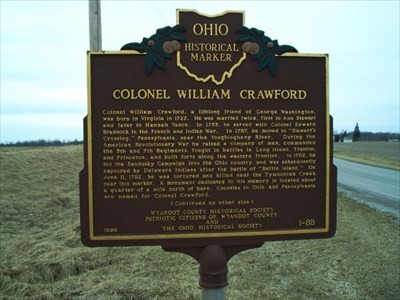

The Colonel Crawford Burn Site Monument County Highway 29 off State Highway 199 Carey OH The Colonel Crawford Burn Site Monument is a war monument in rural Wyandot County, Ohio. Placed in the 1870s, it commemorates the death by burning of Colonel William Crawford during the concluding years of the American Revolution. The stone monument itself was long the subject of local interest, and it has been named a historic site. In 1782, a regiment of Virginia soldiers was sent in reprisal to destroy Indian villages on the Sandusky River, under the command of William Crawford. The Crawford expedition ended on June 4 after a skirmish south of modern-day Carey, and the Americans retreated. Colonel Crawford was captured by the Indians after the battle, and seven days later he was tortured and burned at the stake on the banks of Tymochtee Creek in present-day northeastern Wyandot County. As the centenary of the burning approached, a movement arose to commemorate Crawford's death with a monument. The marker is made of sandstone from Berea, Ohio, worked in the shape of a cannon and cut approximately 6.5 feet tall. Local labor at B.L. Bauscher's firm in Upper Sandusky performed the stone cutting during the middle of 1877, and the monument was dedicated later in the year. In April 1982, the monument was listed on the National Register of Historic Places, qualifying because of its connection to Crawford. Colonel William Crawford was born in Berkeley County, Virginia in 1732. In 1749, he met George Washington, a young surveyor, who taught him the trade and then hired him to do some surveying in western Pennsylvania. Like Washington, Crawford wanted to join the military and explore the frontier. That opportunity arrived during the French and Indian War, when he joined the British army. Impressed with the back country of western Pennsylvania, Crawford in 1765 made his home along the Youghiogheny River. Over the next decade, he served as Justice of the Peace in Cumberland, Bedford, and Westmoreland Counties, and distinguished himself as a formidable Indian fighter, most notably in Lord Dunmore's War against the Shawnee of the Ohio Valley in 1774. During the War for Independence, Crawford was commissioned colonel of the 7th Virginia and served with distinction at the battles of Trenton, Princeton, Brandywine, and Germantown. In late 1777, he took command of the continental troops and militia in western Pennsylvania. He was with George Washington when he made the famous Delaware River crossing in 1777. In 1778 he helped build Fort Laurens along the Tuscarawas River. When the fort was abandoned a year later, Crawford appealed to Congress for more funds for the Western campaign in 1781. When Congress denied this request, Crawford retired from military service. At 50 years of age, Col. Crawford was elected to lead a group of voluntary militia. He won the elected position of colonel by just five votes beating out Col. Williamson who had led this same militia group that was responsible for the Gnadenhutten Massacre. Although Col. Williamson lost his position as commander of the expedition, he was made second in command. The expedition formed up at Mingo Bottom, which was a few miles south of Steubenville on May 25, 1782. From here they planned to march onto Gnadenhutten and from there directly to Sandusky Plains. Several days later, on June 7, Crawford and one of his aides, Dr. Knight, were captured in an ambush. Both men were beaten with fists, stones, sticks and clubs, Dr. Knight survived the captivity and later escaped his captors. But prior to his escape he was an eyewitness to the torturous murder of Col. Crawford on June 11, 1782. Although there is no record where Colonel Crawford was buried, the monument was erected in a small cemetery just east of the small town Crawford.
2 notes
·
View notes
Text
Laurel Ridge State Park - Wikipedia
Laurel Ridge State Park is a 13,625-acre (5,514 ha) Pennsylvania state park that passes through Cambria, Fayette, Somerset, and Westmoreland counties, Pennsylvania in the United States. The park is home to the 70-mile (110 km) Laurel Highlands Hiking Trail that runs through the park from the Youghiogheny River at Ohiopyle to the Conemaugh Gorge near Johnstown. The park was approved by the governor on July 10, 1967, and construction started on the Laurel Highlands Hiking Trail on July 7, 1970.
Laurel Highlands Hiking Trail
Laurel Highlands Hiking Trail is 70 miles (110 km) long, begins at Ohiopyle State Park and ends at Conemaugh Gorge near Johnstown. The trail goes through state forests, state parks, state game lands, and some privately owned lands. Laurel Highlands Hiking Trail is open year round. The trail is marked with yellow blazes. Connector trails are marked with blue blazes. These trails connect the main trail with parking and shelter areas. The trail is marked with large wooden signs at every major highway crossing. Six parking lots at the highway crossings provide starting points; some have access to drinking water.[1]
Shelter areas
There are eight overnight shelter areas on the Laurel Highlands Hiking Trail. These shelter areas are located about every 6 miles (9.7 km) to 10 miles (16 km) along the trail. The shelter areas each have five Adirondack style shelters. There are two outhouses at the rest stops and a water supply. There is room for up to 30 tents at each stop. Firewood is provided. Hikers using the shelters are required to make reservations for use of the shelters with the park staff before setting out on their hike. A fee is charged to users of the shelters.[1]
The Laurel Highlands Hiking Trail mileage starts from the southern trailhead in Ohiopyle State Park. The trail runs east through the park and parallel to the Youghiogheny River within Stewart Township in Fayette County for the first 6 miles (9.7 km).[2] Just past mile 6 the trail comes to the first overnight shelter area (with non-potable water), where it turns northeast.[3] At 7 miles (11 km) the trail leaves the park and Fayette County, and enters Lower Turkeyfoot Township in Somerset County and Pennsylvania State Game Lands No. 111.[4] Just before 15 miles (24 km), the trail enters Laurel Ridge State Park for the first time, where it continues northeast. Just past 17 miles (27 km) the trail turns north, and crosses back into Fayette County (now Springfield Township), where the second overnight shelter with potable water is found.[2][3]
The trail runs generally northeast and passes the Laurel Ridge State Park office near 19 miles (31 km), enters Saltlick Township, Fayette County at about 23 miles (37 km), then leaves the park and enters Forbes State Forest just before 24 miles (39 km).[2] Shortly after this the trail returns to Somerset County (Middlecreek Township) and passes the third overnight shelter area with potable water. Between 25 miles (40 km) and 26 miles (42 km) the trail follows the border between Laurel Ridge State Park and Forber State Forest, then leaves public land for private property. It crosses the borough of Seven Springs and runs just west of Seven Springs Mountain Resort and Laurel Hill State Park.[4] Just before 29 miles (47 km) the trail crosses into Donegal Township in Westmoreland County, and shortly after enters the state forest and then Laurel Ridge State Park again.[5] At about 31.5 miles (50.7 km), the trail crosses back into Somerset County (Jefferson Township), and just past 32 miles (51 km) passes the fourth overnight shelter area, with potable water. It runs west of Kooser State Park and continues for several miles just east of the county line, crossing the Pennsylvania Turnpike (Interstate 70/76) before 37 miles (60 km). The pedestrian bridge over the turnpike was closed in December 2009, when it was deemed to be in such poor condition that it was too unstable to use.[6] The bridge was reopened in January 2012.[7][8] This stretch of trail runs through the state forest and three separate small tracts of Laurel Ridge State Park.[3][4]
At 38 miles (61 km), the trail crosses from the state forest into Laurel Ridge State Park and Lincoln Township in Somerset County, then crosses briefly into Cook Township in Westmoreland County.[4][5][9] It crosses back into Somerset County and comes to the fifth overnight shelter with potable water, then reaches Laurel Summit State Park at 39 miles (63 km). Continuing through the state forest, the trail crosses into Jenner Township in Somerset County just past 41 miles (66 km), and back into Laurel Ridge State Park at 43.5 miles (70.0 km), passing east of Linn Run and Laurel Mountain state parks along this section. The trail crosses U.S. Route 30 just before 46 miles (74 km) and reaches the sixth overnight shelter with potable water just after. It continues through the state park to 50 miles (80 km), then enters State Game Lands No. 42, then crosses into Ligonier Township in Westmoreland County.[5] The trail leaves the Game Lands at 53 miles (85 km), travels through Laurel Ridge State Park for 1 mile (1.6 km), crosses back into the Game Lands, and into Jenner Township in Somerset County again. Just before 55 miles (89 km) the trail again passes through the state park where it enters Conemaugh Township in Somerset County, then enters private land at about 55.5 miles (89.3 km). The trail enters another tract of the state park before 57 miles (92 km), where it crosses Pennsylvania Route 271 and the seventh overnight shelter with potable water is located. Just after this the trail enters State Game Lands No. 42, then at 57.5 miles (92.5 km) crosses into Upper Yoder Township in Cambria County.[9][10]

A shelter along the trail.
The trail continues through State Game Lands No. 42 and crosses back into Westmoreland County (Fairfield Township) just before 59 miles (95 km). At about 60 miles (97 km) the trail enters St. Clair Township in Westmoreland County, and between here and 62 miles (100 km) it crosses twice into Lower Yoder Township in Cambria County. It finally leaves the State Game Lands and enters Laurel Ridge State park for the final time before 63 miles (101 km), crossing back into Cambria County (Lower Yoder Township) shortly after that. The eighth and final overnight shelter with potable water is past 64 miles (103 km) and the trail continues northeast until just before 67 miles (108 km), where it turns north and then crosses into Westmoreland County (St. Clair Township). The trail now runs parallel to the Conemaugh River with several vistas of the river valley, and finally ends at 70 miles (110 km).[9][5][10]
Environment
The park, as well as the Laurel Highlands Hiking Trail, lie within the Appalachian mixed mesophytic forests ecoregion.[11]
Other recreation
The park is open to hunting, cross-country skiing and snowmobiling.[1]
Hunting is permitted on almost all of Laurel Ridge State Park. The most common game species are ruffed grouse, turkey and white-tailed deer. The hunting of groundhogs is prohibited. Hunters are expected to follow the rules and regulations of the Pennsylvania Game Commission.[1]
There are 35 miles (56 km) of trails open to cross-country skiing during the winter months at Laurel Ridge State Park and over 70 miles (110 km) of trails open to snow mobiles.[12]
Nearby state parks
View across the Conemaugh Gorge from the Laurel Ridge Trail.
The following state parks are within 30 miles (48 km) of Laurel Ridge State Park:[13][14]
References
^ a b c d "Laurel Ridge State Park". Pennsylvania Department of Conservation and Natural Resources. Retrieved 2006-12-02.
^ a b c 2007 General Highway Map Fayette County Pennsylvania (PDF) (Map). 1:65,000. Pennsylvania Department of Transportation, Bureau of Planning and Research, Geographic Information Division. Retrieved 2006-07-27.[permanent dead link]Note: shows Laurel Ridge State Park
^ a b c Laurel Ridge State Park (south park map) (PDF) (Map). 1 inch = 1.3 miles. Pennsylvania Department of Transportation, Bureau of Planning and Research, Geographic Information Division. Retrieved 2007-11-12. Note: shows Laurel Highlands Hiking Trail
^ a b c d 2007 General Highway Map Somerset County Pennsylvania (PDF) (Map). 1:65,000. Pennsylvania Department of Transportation, Bureau of Planning and Research, Geographic Information Division. Retrieved 2006-07-27.[permanent dead link]Note: shows small tracts of Laurel Ridge State Park not shown on the DCNR trail map
^ a b c d 2007 General Highway Map Westmoreland County Pennsylvania (PDF) (Map). 1:65,000. Pennsylvania Department of Transportation, Bureau of Planning and Research, Geographic Information Division. Retrieved 2006-07-27.[permanent dead link]Note: shows Laurel Ridge State Park
^ Schmitz, Jon (2009-12-26). "Closed bridge splits hiking trail: Span was only way for outdoors lovers to cross turnpike". Pittsburgh Post-Gazette. Retrieved 2009-12-26.
^ Nass, Shannon (2012-02-05). "Bridge is back on Laurel Highlands trail". Pittsburgh Post-Gazette. Retrieved 3 June 2013.
^ Brady, Terry. "DCNR Dedicates New Laurel Highlands Hiking Trail Bridge" (PDF). DCNR. Retrieved 3 June 2013.
^ a b c Laurel Ridge State Park (north park map) (PDF) (Map). 1 inch = 1.3 miles. Pennsylvania Department of Transportation, Bureau of Planning and Research, Geographic Information Division. Retrieved 2007-11-12. Note: shows Laurel Highlands Hiking Trail
^ a b 2007 General Highway Map Cambria County Pennsylvania (PDF) (Map). 1:65,000. Pennsylvania Department of Transportation, Bureau of Planning and Research, Geographic Information Division. Retrieved 2006-07-27.[permanent dead link]Note: shows Laurel Ridge State Park
^ Olson, D. M, E. Dinerstein; et al. (2001). "Terrestrial Ecoregions of the World: A New Map of Life on Earth". BioScience. 51 (11): 933–938. doi:10.1641/0006-3568(2001)051[0933:TEOTWA]2.0.CO;2. Archived from the original on 2011-10-14.CS1 maint: Multiple names: authors list (link)
^ "Laurel Highlands Hiking Trail informational page". Retrieved 2007-07-24.
^ Michels, Chris (1997). "Latitude/Longitude Distance Calculation". Northern Arizona University. Retrieved 2008-04-23.
^ "Find a Park by Region (interactive map)". Pennsylvania Department of Conservation and Natural Resources. Retrieved November 18, 2011.
External links
0 notes
Text
Paumanok
IT MAY or may not be true that the locomotive in Whitman’s To a Locomotive in Winter, with its fierce beauty and irresistible energy, devouring distance, cars trailing behind it, was a symbol for the high-pressured, the spiritually and physically burning Mrs. Gilchrist, who came from London to marry him. The guess is not out of the way, for Whitman was a symbolist long before this poem was written, a symbolist, indeed, before symbolism. As soon as he found his own kind of poetry, he began to write, as he said, ‘indirectly’, by which he usually meant in symbols.
[...]
The Walt Whitman country in rural Long Island is west of the middle, beginning twenty to thirty miles from New York and extending from Long Island Sound to the Atlantic Ocean, which are so close together that the booming surf of an ocean storm could be heard on the low hills above the Sound where he was born.
[Henry Seidel Canby, Walt Whitman: An American]
===
Sir Francis Drake sailed into San Francisco’s harbor in 1579 and saw a land of plenty. ‘Infinite was the company of very large and fate Deere’, he announced. how could he have known that just a century before the shoreline had been thickly settled and the deer much more scarce?
Not all of these claims have been endorsed enthusiastically... Elk are big and Indians may have butchered them where they fell, meaning that few elk carcasses would appear in middens. Nonetheless, ecologists and archaeologists increasingly agree that the destruction of native Americans also destroyed the ecosystems they managed. Throughout the eastern forest the open, park-like landscapes observed by the first Europeans quickly filled in. Because they did not burn the land with the same skill and frequency as its previous occupants, the forests grew thicker. Left untended, maize fields filled in with weeds, then bushes and trees.
[1491]
===
In a Chicago theater on May 6, 1919, fifty-five-year-old tinsmith and IWW member George Goddard refused to stand and remove his hat during the ‘Star Spangled Banner’. Apprentice seaman Samuel A. Hagerman shot three times. The audience cheered.
[...]
In January 1920, a judge sentenced Waterbury, Connecticut, clothing salesman and Socialist Party member Joseph Yenowsky to six months in jail for allegedly remarking that Lenin was the smartest man in the world and that Yenowsky wanted a Soviet-style government here.
[...]
In February 1920 in Hammond, Indiana, Italian-born Frank Petroni, a naturalized immigrant, argued with Austrian-born laborer Frank Petrich, an unnaturalized radical, over italian claims to former Austrian territory. The twenty-five-year-old Petrich finally yelled, ‘To hell with the United States’. Petroni shot him dead. Petroni pled not guilty by reason of patriotism. The jury deliberated two minutes before setting Petroni free.
[1920]
===
Who was Cain’s wife? and what was ‘the mark of Cain?’ Like Adam, Cain is creative consciousness, therefore his wife is planetary energy. They meet and marry in a city called Earth. This earth, or matter, is ‘the mark of Cain’. Prior to the sun period, the nascent earth was an invisible entity, threatened with destruction by the violent suns that crossed its cosmic pathway. Thereafter it put on matter, it became visible, violent and self-protective like all other suns.
Here we can erase another Bible-inspired stigma. For centuries this ‘mark of Cain’ was interpreted as black skin, and the Negro people suffered from it. They were called ‘the children of Cain’ and scorned by whites so ignorant they did not know fact from fiction. These whites should now learn that this ‘mark’ is materiality and that it is they, not the Negro, who bears it today.
[Deceptions and Myths of the Bible]
===
gentian | Gentiana
‘I have seldom – no, change that to never successfully established a gentian in any garden I have been associated with’... ‘This unrequited-love stuff is for the birds!’... closed, or bottle gentian (Gentiana andrewsii) is said to be one of the easiest to grow – and it is best grown in groups, no singletons... to propagate, ‘collect the seeds, sow in a coarse medium of 3:1 perlite:peat, and place in a sheltered area outdoors, such as in a cold frame’... they ‘will’ germinate the following spring... as for division, ‘if a fine colony is established, leave it alone’...
[Armitage’s Native Plants]
===
long-horned beetles | Melissodes
The horns, as it were, are the long antennae they wear; the thick tufts of hairs on their hind legs, used for gathering pollen, ‘resemble chaps’... the melon bee (Melissodes bimaculata) ‘deserves special specific mention as a conspicuous and common garden visitor, often gathering pollen from sunflowers as well as melons’... their nests are in underground nests or in nearby turf...
Vegetables commonly pollinate by flies include brassicas and alliums; they are the primary pollinators of carrots, cilantro, and fennel... hover flies (Syrphidae) munch on aphids...
===
spikenard | Aralia racemosa
To 6 ft. ... perennial; zone 4... stratify fresh seed for 40 days... can be propagated by root cuttings... can handle urban environments... ‘The large leaves give a dramatic, subtropical effect that can draw attention to the back of the shade garden’... the spikenard of Bible fame is Nardostachys jatamansi... Native Americans dined on the roots; combined it with ‘wild onion, gooseberry, and honey. They also relished the young tips in soups’... has in the past been used to treat gout, dysentery, syphilis, ringworm rheumatism, heart problems, and ‘local pains’... the juice of the berries, inserted into the ear canal, will cure your earaches...
===
❚Jerry Lewis turns 91 today
Dietary anti-cancer compound may work by influence on cellular genetics
Summary: Sulforaphane, a dietary compound from broccoli that's known to help prevent prostate cancer, may work through its influence on long, non-coding RNAs, report scientists.
Grazing cows rush to listen to accordion music
A herd of cows come over to hear accordion music played by this man in Garmisch, Germany. It's so crazy how they truly enjoy the music!
Dog introduced to dairy cow, unexpected playtime ensues
Gutter Trash
Sebastian Gorka’s ties to a group of Nazi collaborators is a new low for Donald Trump’s administration.
In a quiet stretch of protected woodlands in southeastern Allegheny County, conservationists are laying the groundwork for more sustainable wildlife habitats and recreational trails.
The expanse, called Dead Man’s Hollow, has remained a focal point for the Allegheny Land Trust for more than two decades. But in recent years, the organization has sought not only to enrich its natural beauty and biological diversity but also to draw attention to its crumbling vestiges of industrial activity that date to the late 19th century.
“So often we see forests being developed or destroyed,” said Keri Rouse, the land trust’s community coordinator for the site. But “nature has really reclaimed that area.”
Encompassing about 450 acres, the tract is the largest privately protected conservation area in the county and the most undisturbed tributary valley in the Youghiogheny River valley. It lies in Elizabeth Township, Liberty and Lincoln.
The Irish Hunger Memorial is a one half acre plot of land nestled among Manhattan skyscrapers in New York City. The memorial features a ruined Famine era stone cottage dismantled in County Mayo, and reassembled in downtown New York.
‘Saturday Night Live’ to Air Live Across the Country
You ordered a pizza, but when you get it you find it has the wrong toppings. The prudent thing to do would be to A) return it and ask for a refund, B) just forget about it and eat it the way it is, or C) pump bullets into the building from your car.
McDonald's claims their Twitter account was hacked after tweet makes Trump grimace
1 note
·
View note
Text
Markvue Manor <b>sewer</b> project moves ahead
The sewer line replacement projects are part of the authority's $11.1 million five-year capital improvement plan — $7.1 million is for the wastewater conveyance system, including sewer lines, and $4 million is for the Youghiogheny Treatment Plant on Turner Valley Road, Branthoover said. The capital ...
from Google Alert - sewage system https://www.google.com/url?rct=j&sa=t&url=http://triblive.com/local/norwin/13242983-74/markvue-manor-sewer-project-moves-ahead&ct=ga&cd=CAIyGjBmYTExMmY5ODc5OTYxMmI6Y29tOmVuOlVT&usg=AFQjCNHylf6iEI3lCtWfOuEtDf2DPyVxKw
0 notes
Text
One of my more popular poems
One of my more popular poems
Fatherhood
There was the valley,
the Youghiogheny cutting
through rounded mountains,
the red clay my father dug
with pickax and shovel
to force a home from
the grudging hillside.
The time was new, the clay
dark red with iron,
the wind warm enough
for summer, but not so
hot you’d think of death.
My father grunted with
each heft and swing.
He sculpted that clay
with the same careful
touch he used…
View On WordPress
0 notes
Link
'Why not make more of it here?' Stephen Huba Updated 2 hours ago President Trump's promise to bring steel jobs back to Pittsburgh was widely lampooned, but not in the offices of Dura-Bond Industries. The Export-based company has steadily, over the past 13 years, turned itself into one of the go-to manufacturers of steel pipe in the United States. It employs about 550 people and is preparing to add 100 more jobs in the historic steel-making heart of the Mon Valley later this year. So when Trump signaled his support for domestic steel during the presidential campaign, Dura-Bond President Jason Norris sat up and took notice. “He's said it a number of times — that he wants pipelines that are installed in the United States to be made in the United States, with steel melted and rolled in the United States,” Norris said. “There's always going to be a need for pipe, even if it's not transporting natural gas. Civilization was started with pipe.” Dura-Bond bills itself as a premier provider and coater of pipe for the oil and gas industry, but it's the company's proximity to Pennsylvania's steel-making centers that has made that possible, Norris said. The private, family-owned company recently announced that it was reactivating the former U.S. Steel McKeesport Tubular Operations and retooling it for the manufacture of smaller, midstream pipe. U.S. Steel idled the plant in 2014 because of the downturn in the oil and gas industry and the glut of cheap imports from overseas. An estimated 260 people lost their jobs. Dura-Bond's agreement with U.S. Steel includes the purchase of all the equipment on the 317,000-square-foot site, which sits at the confluence of the Monongahela and Youghiogheny rivers. Dura-Bond is leasing the land and the buildings from the Regional Industrial Development Corp., with an option to purchase at a later date. “They're making a major capital investment into the site,” said RIDC Senior Vice President Timothy White. “It's certainly one of the biggest deals in the Mon Valley in recent years.” Parties to the deal declined to discuss specific dollar amounts, but Norris said the company will focus on upgrading equipment and investing in new technology before reopening the McKeesport mill. Within six to nine months, Dura-Bond hopes to build on its experience operating the former Bethlehem Steel mill in Steelton, near Harrisburg, Norris said. At 47, Norris is the third generation of his family to be involved with the business. His brothers, Ryan and Adam, also are active with the company. Dura-Bond was founded in 1960 by his grandfather, Jim “Buster” Norris, who came to Export from Alabama as a 16-year-old. The business expanded as the technology of pipe coating changed from coal tar to more sophisticated forms of corrosion protection. Dura-Bond operated a coating facility near the McKeesport Tubular Operations through 2011 and opened a new plant in Duquesne in 2012. “(U.S. Steel) made most of the pipe that we coated,” Norris said. Dura-Bond acquired the Bethlehem Steel pipe mill in 2003 and started manufacturing pipe there in 2004. “The coating plant had no future without being next to a pipe mill,” Norris said, noting that the Bethlehem deal provided the template for the most recent acquisition. “It's the same situation as in Steelton. We have a coating plant (in Duquesne) that we spent $12 million on, but without having a producing mill in close proximity, its days are numbered.” Driving the recent deal with U.S. Steel and RIDC is Norris' belief that the oil and gas industry will bounce back in Western Pennsylvania, opening up opportunities for the manufacture of midstream piping and smaller-capacity transmission lines. “Oil and gas always has peaks and troughs. … You have to be ready to capitalize on that when it comes out of the trough,” he said. “Obviously, we feel that the market's going to come back. It may not come back as strong as it was, but it's going to come back.” Norris also believes that the growing pipeline infrastructure in the United States should be made with domestic pipe whenever possible. While he has purchased steel from overseas suppliers, he anticipates buying coil steel for the McKeesport operation from U.S. Steel, ArcelorMittal and other domestic suppliers. The economic impact of buying imported steel is limited, while relying on domestic steel produces a ripple effect, Norris said. “I see this being an American mill, buying American steel,” he said. “My (coating) mill and that steel mill generate revenue and spend money that is pumped back out into the economy. … It's not just 100 jobs making pipe — it's thousands of people that support that piece of pipe.” Norris said the response to Dura-Bond's announcement has been “overwhelming” and that he expects to fill all the jobs locally. Manufacturing, he insists, is not dead. “We can't let somebody else make all the stuff and act like it doesn't exist,” he said. “It's going to be made. Why not make more of it here? … More than 50 percent of the oil and gas pipe used in the United States comes from overseas, and that must change.” The Dura-Bond announcement shows that the “legacy” industries of steel, manufacturing and energy are still vital for the economic health of the region, said Philip Cynar, spokesman for the Allegheny Conference, an economic development agency. “It's exciting when a company like Dura-Bond, a full-blooded manufacturer, sees an emerging opportunity and is able to run with it,” Cynar said. “We hope that market conditions will be such that these types of partnerships will only increase.” Dura-Bond is providing the steel pipe for the Atlantic Coast Pipeline LLC, a 550-mile natural gas pipeline that will run from Harrison County, W.Va., to Virginia and North Carolina. Stephen Huba is a Tribune-Review staff writer. Reach him at 724-850-1280 or [email protected].
#americanenergy#American steel#American pipe#American pipelines#domestic pipelines#oilbusiness#steel jobs
0 notes
Text
Ohiopyle, Pennsylvania Circa Early 1970'S
(just in time for summer reading...
recounting emotionally disastrous campy turbulence)
Amidst a raft of fellow (Brandywine Valley
Y.M.C.A) resident campers
who, didst excitedly quiver
donning a "NON FAKE" lifejacket
coursing down swiftly
moving Youghiogheny river
(evidenced by small hairs along spine),
that caused me animatedly to shiver
this predisposition prevailed despite
punishing revenge didst stamp excite
me inducing suppressed
giddiness to take flight
against self toward parents,
who did light,
a conspiratorial idea
countered meek self spite
compared to their hefty might
forced me to attend ("dumb")
sleep away camp
for about a fortnight
whereupon, being dropped off "bright"
brainchild idea awoke around edge,
of my consciousness,
where figurative hatchet cleft a wedge
vis a vis, an immediate
avowed personal pledge
sworn against experiencing even
one iota of fun (a ha...so there) ledge
er domain mental prestidigitation
could not dredge
countervailing loathsomeness naysaying fun
in any weigh, shape or form
pertaining to this sole son
but, matter of fact
adventuresome giddiness gave run
for metaphorical psychological money,
and much to my chagrin
gleefulness didst stun
into silence malevolent
anti yippee surge
crept into the noggin of this
chaim yankel and could not purge
this meta static Grinch,
who could not steal away
euphoria that inevitably didst emerge
unable to root out,
and suppress nemesis foe
men ting misery, but an inescapable glow
manifested when father
and mother end of Jeff session
came back, and said "hello"
when, and I immediately replied with emphatic "NO"
in regard to having a good time oh
mitt ting like a lump pin pro
let tarry yet exerting will
power to asphyxiate
a faint bubbling of attraction
toward a darker skinned
slender cute teen age girl
though at that stage
oblivious how to create
friendship, thus aye
vividly recall to this date
hop scotched potential summer romance
which induces regret to emanate
cursing forsaken ill fate
now, feel deplorable
for stifling relationship
slid into behavioral sink (of this got
ham) fore'r tortured
within iron barred gate.
0 notes
Video
James Cochran House by Joseph
Via Flickr:
The opulent Victorian James Cochran House in Dawson, PA was built in 1890 for a local coal and coke magnate. The Youghiogheny Valley near the western ridge of the Alleghenies has been a historically significant mining region.
#house#Dawson#Fayette County#Youghiogheny Valley#Pennsylvania#historic#Architecture#dream house#victorian#regal#luxury#love#victorian house#dream home#victorian home#lovely#cute#fancy#elegant
111 notes
·
View notes
Last Seen Blogs

s0lam33y
Sol

aricante
Arcane Discover the Secrets of Aristotle and Dante

potterymakinginfo
Pottery Making Info

existiendo-en-letras
Existiendo en letras

faramirsonofgondor
Finally A Chance To Show My Quality