#agricultural land for sale colorado
Text
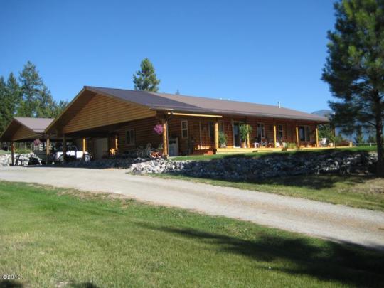
Discover the Beauty of Horse Farms in Colorado
Colorado Lifestyle Properties presents premier horse farms for sale in Colorado, offering unparalleled opportunities for equestrian enthusiasts. Nestled amidst the breathtaking landscapes of Colorado, our listings feature expansive ranches with state-of-the-art facilities tailored to horse care and training. Whether you seek a private retreat or a professional facility, our diverse portfolio caters to your aspirations.
#Horse Farms for Sale in Colorado#agricultural land for sale colorado#farms and ranches for sale in colorado#horse ranches for sale in colorado#horse property for sale colorado springs
0 notes
Text
In rural Arizona’s La Paz County, on the state’s rugged border with California, the decision by a Saudi-owned dairy company to grow alfalfa in the American Southwest for livestock in the Gulf kingdom first raised eyebrows nearly a decade ago. Now, worsening drought has focused new attention on the company and whether Arizona should be doing more to protect its groundwater resources.
Amid a broader investigation by the state attorney general, Arizona last week rescinded a pair of permits that would have allowed Fondomonte Arizona, a subsidiary of Almarai Co., to drill more than 1,000 feet (305 meters) into the water table to pump up to 3,000 gallons (11 kiloliters) of water per minute to irrigate its forage crops.
In an interview with The Associated Press, Attorney General Kris Mayes said she thought most Arizonans see it as “outrageous” that the state is allowing foreign-owned companies “to stick a straw in our ground and use our water for free to grow alfalfa and send it home to Saudi Arabia. We just can’t — in the midst of an epic drought — afford to do dumb things with water in the state of Arizona anymore.”
Mayes, a Democrat, sought the revocations after she said her office had found inconsistencies in the permit applications. Mayes vowed to look into Fondomonte’s operations and water use last year after the Arizona Republic reported that the Arizona State Land Department leased the company thousands of acres of farmland for below market value.
Fondomonte did not respond to multiple requests for comment from the AP. Its lawyers have said previously that the company legally leased and purchased land in the U.S. and spent millions on infrastructure improvements.
Years of drought have ratcheted up pressure on water users across the West, particularly in states like Arizona, which relies heavily on the dwindling Colorado River. The drought has also made groundwater — long used by farmers and rural residents with little restriction — even more important for users across the state.
Saudi Arabia, struggling with its own water shortages in the past decade, restricted the growth of some forage crops in the country. That Fondomonte chose Arizona as a place to grow such crops has angered some in the state, which has faced two consecutive years of federal water cuts from the Colorado River, a primary water source for the state.
Officials from both parties have criticized the use of state water by foreign-owned entities, with Gov. Katie Hobbs, also a Democrat, saying in her January state of the state address that she, too, would look into the practice. The state’s groundwater, Hobbs said, “should be used to support Arizonans, not foreign business interests.”
That same month, Republican state legislators introduced a bill to prohibit sales of state lands to foreign governments, state enterprises and any company based in China, Russia or Saudi Arabia.
“There’s a perception that water goes to local uses,” said Andrew Curley, a professor of geography and the environment at the University of Arizona. “When you recognize it’s going far away, that the products and benefits of this water are exported overseas, that really provokes people’s attention.”
Foreign entities and individuals control roughly 3% of U.S. farmland, according to the U.S. Department of Agriculture. Canada is the largest holder — mainly of forestland. Fourteen U.S. states have restrictions on foreign individuals or entities owning farmland, but limitations vary widely and no state completely prohibits it.
Fondomonte also farms in California’s Palo Verde Valley, an area that gets its water from the Colorado River. Those operations have attracted less scrutiny. And it’s not the only foreign company that farms in the Southwest. The United Arab Emirates-owned Al Dahra ACX Global Inc. grows forage crops in Arizona and California, and is a major North American exporter of hay.
U.S. farmers themselves export hay and other forage crops to the Middle East — mainly to Saudi Arabia. China is the primary export market for U.S. hay.
In Arizona, renewed attention to Fondomonte’s water use is raising questions about the state’s lack of regulation around pumping groundwater in rural parts of the state.
Phoenix, Tucson and other Arizona cities have restrictions on how much groundwater they can pump under a 1980 state law aimed at protecting the state’s aquifers. But in rural areas, little is required of water users besides registering wells with the state and using the water for activities, including farming that are deemed a “beneficial use.”
“Frankly, I believe they are not doing their jobs,” Mayes said about Arizona’s Department of Water Resources’ oversight of rural areas. The Department declined to comment on the revoked drilling permits or the need for more groundwater regulation.
Mayes, along with hydrologists and environmental advocates, says more studies are needed of groundwater basins in rural areas — such as La Paz County, an agricultural county of about 16,000 people. Currently, Arizona doesn’t measure how much groundwater users pump in such areas, which means there is little understanding of how much water an operation like Fondomonte — or other farms — uses.
Almarai’s holdings in the Southwest are just one example of the farmland the company and its subsidiaries operate outside Saudi Arabia. It farms tens of thousands of acres in Argentina, which has also faced severe drought conditions in recent years.
Holly Irwin, a member of the La Paz County Board of Supervisors, has long opposed Fondomonte using water in the county. She said she’s fielded complaints from residents for years that it’s getting harder to pump water in nearby wells and has repeatedly asked the state to do something about it.
“We need to have some sort of regulation so it’s not all just being pumped out of the ground,” Irwin said.
#us politics#news#the associated press#ap news#Arizona#2023#saudi arabia#La Paz County#Fondomonte Arizona#Almarai Co.#drought#groundwater resources#foreign companies using domestic resources#Kris Mayes#Arizona State Land Department#Colorado River#Gov. Katie Hobbs#Andrew Curley#Department of Agriculture#Al Dahra ACX Global Inc.#Arizona Department Of Water Resources
6 notes
·
View notes
Text
How to Sell My Commercial Property Fast Nationwide USA
Sell My Commercial Property for Cash Nationwide USA. We Buy Commercial Properties. Fair Cash Offers. We Buy Commercial Real Estate. Any Location, Commercial, Houses & Land: Residential, Commercial, Industrial, Agricultural. Sell Commercial Property Fast!
Sell Commercial Real Estate
How To Turn A Vacant Commercial Property Into Cash Fast Nationwide USA
Do you have a fixer-upper or vacant commercial property? Figure out how to turn your commercial properties into cash the fast and simple way! Inside our latest post, we will explore why more and more people are looking to a quick sale for their commercial property.
Nationwide USA
Alabama | Alaska | Arizona | Arkansas | California| Colorado | Connecticut | Delaware | Florida | Georgia | Hawaii | Idaho | Illinois | Indiana | Iowa | Kansas | Kentucky | Louisiana | Maine | Maryland | Massachusetts | Michigan | Minnesota | Mississippi | Missouri | Montana | Nebraska | Nevada | New Hampshire | New Jersey | New Mexico | New York | North Carolina | North Dakota | Ohio | Oklahoma | Oregon | Pennsylvania | Rhode Island | South Carolina | South Dakota | Tennessee | Texas | Utah | Vermont | Virginia | Washington | West Virginia | Wisconsin | Wyoming | Washington DC (District of Columbia)
Worldwide
Afghanistan, Aland Islands, Albania, Algeria, American Samoa, Andorra, Angola, Anguilla, Antarctica, Antigua and Barbuda, Armenia, Aruba, Australia, Austria, Azerbaijan, Bahamas, Bahrain, Bangladesh, Barbados, Belarus, Belgium, Belize, Benin, Bermuda, Bhutan, Bolivia, Plurinational State of Bonaire, Sint Eustatius and Saba, Bosnia and Herzegovina, Botswana, Bouvet Island, British Indian Ocean Territory, Brunei Darussalam, Bulgaria, Burkina Faso, Burundi, Cabo Verde, Cambodia, Cameroon, Canada, Cayman Islands, Central African Republic, Chad, Chile, China, Christmas Island, Cocos (Keeling) Islands, Colombia, Comoros, Congo, Congo, The Democratic Republic of The Cook Islands, Costa Rica, Cote D'ivoire, Croatia, Cuba, Curacao, Cyprus, Czech Republic, Denmark, Djibouti, Dominica, Dominican Republic, Ecuador, Egypt, El Salvador, Equatorial Guinea, Eritrea, Estonia, Ethiopia, Falkland Islands (Malvinas), Faroe Islands, Fiji, Finland, France, French Guiana, French Polynesia, French Southern Territories, Gabon, Gambia, Georgia, Germany, Ghana, Gibraltar, Greece, Greenland, Grenada, Guadeloupe, Guam, Guatemala, Guernsey, Guinea, Guinea-Bissau, Guyana, Haiti, Heard Island and Mcdonald Islands, Holy See, Honduras, Hong Kong, Hungary, Iceland, India, Indonesia, Iran, Islamic Republic of Iraq, Ireland, Isle of Man, Israel, Italy, Jamaica, Japan, Jersey, Jordan, Kazakhstan, Kenya, Kiribati, Korea, Democratic People's Republic of Korea, Republic of Kuwait, Kyrgyzstan, Lao People's Democratic Republic, Latvia, Lebanon, Lesotho, Liberia, Libya, Liechtenstein, Lithuania, Luxembourg, Macao, Macedonia, The Former Yugoslav Republic of Madagascar, Malawi, Malaysia, Maldives, Mali, Malta, Marshall Islands, Martinique, Mauritania, Mauritius, Mayotte, Mexico, Micronesia, Federated States of Moldova, Republic of Monaco, Mongolia, Montenegro, Montserrat, Morocco, Mozambique, Myanmar, Namibia, Nauru, Nepal, Netherlands, New Caledonia, New Zealand, Nicaragua, Niger, Nigeria, Niue, Norfolk Island, Northern Mariana Islands, Norway, Oman, Pakistan, Palau, Palestine, State of Panama, Papua New Guinea, Paraguay, Peru, Philippines, Pitcairn, Poland, Portugal, Puerto Rico, Qatar, Reunion, Romania, Russian Federation, Rwanda, Saint Barthelemy, Saint Helena, Ascension and Tristan Da Cunha, Saint Kitts and Nevis, Saint Lucia, Saint Martin (French Part), Saint Pierre and Miquelon, Saint Vincent and The Grenadines, Samoa, San Marino, Sao Tome and Principe, Saudi Arabia, Senegal, Serbia, Seychelles, Sierra Leone, Singapore, Sint Maarten (Dutch Part), Slovakia, Slovenia, Solomon Islands, Somalia, South Africa, South Georgia and The South Sandwich Islands, South Sudan, Spain, Sri Lanka, Sudan, Suriname, Svalbard and Jan Mayen, Swaziland, Sweden, Switzerland, Syrian Arab Republic, Taiwan, Province of China, Tajikistan, Tanzania, United Republic of Thailand, Timor-Leste, Togo, Tokelau, Tonga, Trinidad and Tobago, Tunisia, Turkey, Turkmenistan, Turks and Caicos Islands, Tuvalu, Uganda, Ukraine, United Arab Emirates, United Kingdom of Great Britain and Northern Ireland, United States Minor Outlying Islands, United States of America, Uruguay, Uzbekistan, Vanuatu, Venezuela, Bolivarian Republic of Vietnam, Virgin Islands, British, Virgin Islands, U.S., Wallis and Futuna, Western Sahara, Yemen, Zambia, Zimbabwe
1 note
·
View note
Text
Deciphering Farm Appraisal Services: An Insightful Overview
Farm appraisal services encompass a specialized field dedicated to evaluating the worth of agricultural land and properties. Whether situated amidst the sprawling landscapes of Oklahoma or the picturesque terrains of Colorado, these services play a pivotal role in determining the monetary value of farms and rural estates.
Here's a closer look at what farm appraisal services entail:
Evaluation of Agricultural Land: Farm appraisal services delve into assessing various aspects of agricultural land, including soil quality, topography, accessibility, and potential for cultivation.
Market Analysis: Professionals in farm appraisal services Oklahoma conduct thorough market analyses to gauge the demand for agricultural properties in specific regions, such as Oklahoma and Colorado.
Financial Considerations: Assessing the financial aspects of farm properties involves analyzing factors like revenue generation potential, operational costs, and investment returns.
Regulatory Compliance: Farm appraisals adhere to regulatory guidelines and standards set forth by relevant authorities, ensuring accuracy and legality in the appraisal process.
Now that we've scratched the surface of farm appraisal services, let's delve deeper into the realm of land appraisal and its significance.
Understanding the Dynamics of Land Appraisal
Farm appraisal services Colorado, serves as a cornerstone in the realm of real estate transactions and property valuation. Whether it's a sprawling farm in the heart of Oklahoma's countryside or a scenic ranch nestled in Colorado's rugged terrain, understanding the value of land is essential for making informed decisions.
Unveiling the Process of Land Appraisal
Curious about how land appraisal unfolds? Here's a step-by-step breakdown:
Property Inspection: The appraisal process kicks off with a comprehensive inspection of the land, wherein appraisers assess various factors such as size, location, amenities, and overall condition.
Data Collection: Appraisers gather pertinent data related to the property, including recent sales of comparable lands, zoning regulations, environmental factors, and any unique attributes that may impact its value.
Market Analysis: Conducting a thorough market analysis is integral to the appraisal process, as it provides insights into current trends, demand-supply dynamics, and pricing patterns within the local real estate market.
Valuation Methods: Appraisers employ various valuation methods, such as the sales comparison approach, income approach, and cost approach, to ascertain the fair market value of the land.
Documentation and Reporting: Upon completing the appraisal, appraisers compile their findings into a detailed report, outlining the methodologies used, factors considered, and the determined value of the land.
Significance of Land Appraisal
Why is land appraisal crucial? Here are some key reasons:
Informed Decision Making: Whether you're buying, selling, or refinancing land, having an accurate appraisal ensures that you make informed decisions aligned with the property's true worth.
Legal Compliance: Land appraisals adhere to regulatory standards and serve as legally binding documents in real estate transactions, providing assurance and credibility to all parties involved.
Financial Planning: Appraisal for land plays a vital role in financial planning and investment strategies, enabling landowners to leverage their assets effectively and maximize returns.
Dispute Resolution: In cases of property disputes or litigation, land appraisal services, services as objective assessments of the land's value, facilitating fair and impartial resolutions.
0 notes
Text
Target 'sortation' center coming to Detroit fairgrounds site

By Kirk Pinho I July 11, 2023 I Crain’s Detroit
A Target Corp. distribution facility is expected to open on the former Michigan State Fairgrounds site in Detroit.
The building would clock in at about 180,000 square feet on a portion of the sprawling property at Eight Mile Road and Woodward Avenue, where the state's largest Amazon.com Inc. distribution facility has been constructed after being announced almost three years ago, the Minneapolis-based retail giant confirmed Tuesday.
The Target facility was first reported by The Detroit News on Monday.
Through a spokesperson, a message was sent to Detroit-based developer and landlord The Sterling Group, who is co-developing the majority of the property with Dallas-based Hillwood Enterprises LP.
Target did not respond to additional questions about the building.
A sign on the site — generally referred to as Parcel A — says a logistics-style building is expected to be open in June. A rendering shows a new building with some red on its front, but no tenant identified.
The contractors listed are Oliver/Hatcher Construction and MiG Construction.
In February, Target said it was opening more than a half-dozen sortation centers in a $100 million investment in markets across the U.S.
Those new facilities, expected to be online by 2026, add to its fleet of existing sortation centers in Minnesota, Texas, Colorado, Illinois, Georgia, Pennsylvania and Illinois. Its three most recent centers opened around Chicago and Denver. At the time, the company said its new facilities will end up "creating hundreds of new jobs in local metro areas with market-leading wages."
The sortation centers are a way to help Target compete with the rise in e-commerce. They receive orders prepared by store employees and send them out through a delivery network, whether that's Shipt or another third-party provider. Target refers to it as part of its "stores-as-hubs" strategy, using its brick-and-mortar big-box stores "as a launchpad for online orders."
The company said last year that its online sales rose nearly $13 billion from 2019 to 2021 and stores fulfilled more than 95% of total sales in 2021. Some 50 million packages are expected to go through Target sortation centers this year, double from last year, the company said.
Frank Hammer, a co-chair of the State Fairgrounds Development Coalition, which has been vocal in criticizing various components of the 142-acre property's redevelopment plan over many years, said the Target facility is going on the site of the old Joe Dumars Fieldhouse/Agricultural Building, demolition of which came as a surprise to his organization. He and members of the community first became aware of the incoming Target building when told by a city official during a Zoom meeting in May, Hammer said.
The Target facility would join the gargantuan Amazon facility, which is the size of approximately 20 typical Walmart stores.
"The idea that the fairgrounds can be turned into this mammoth logistics center ... We have a lot of feelings about that, because the fairgrounds actually plays a very critical role in Detroit and in the region, and the state," Hammer said.
The Sterling Group/Hillwood JV is also working on another building already under construction on the site, although its ultimate occupant is not yet known. It's expected to be about 292,000 square feet, per marketing materials from the Southfield office of Colliers International Inc., which has the listing.
Sterling Group and Hillwood paid $9 million for the fairgrounds site and no city tax breaks or incentives have been involved. The city paid $7 million for it in April 2020. The lack of tax incentives and the fact that the JV paid the appraised value of the land allowed it to skirt the city's community benefits ordinance process, which is triggered at $75 million.
"Our efforts from the very, very beginning was the notion of community input into what would become of the fairgrounds," Hammer said. "That was really our premise, in terms of our involvement. When the community benefits ordinance passed in 2016, we saw that as an opportunity ... That was something that was legislated, that this development, certainly Amazon would have, you know, come under the terms of the community benefits ordinance."
The $400 million Amazon facility started construction in late 2020.
To read this article on Crain’s Detroit Business: https://www.crainsdetroit.com/real-estate/target-bring-warehouse-michigan-state-fairgrounds
0 notes
Text
3D Real Estate - Colorado Agricultural Land For Sale
3D Real Estate - Colorado Agricultural Land For Sale
Jefferson County
Jefferson County, or “Jeffco,” is a thriving business, industrial, recreational and residential community west of Denver. Named after Thomas Jefferson, the nation’s third president, Jeffco’s majestic landscape combines prairie grasslands and craggy rock formations with rugged mountains and tumbling mountain streams.
The county is home to a mix of mom-and-pop shops and major corporations, including Lockheed-Martin. Coors Brewery in Golden, two medical centers and Terumo BCT are additional significant employers.
The county’s nationally recognized Open Space program offers an extensive range of outdoor recreational activities. Jefferson County also contains parts of three national forests, including Pike and Roosevelt, as well as Golden Gate Canyon State Park. All offer miles of trails and spectacular backcountry hiking terrain.
Arapahoe County
As one of Colorado’s fastest growing counties, Arapahoe is home to vibrant urban, suburban and rural communities. Its 805 square miles encompass a diversity of cultures and lifestyles, with unparalleled open space and trails, major employment centers and a robust multimodal transportation network.
Arapahoe County residents take great pride in their community. They are committed to ensuring their children get the best possible education, embracing the outdoor opportunities that are a hallmark of the area and supporting local businesses.
The county is home to 13 cities and towns, 450 local improvement districts and nine school districts, and boasts one of the lowest property tax mill levies in the state. Its County government keeps only 15 percent of the funds it collects for itself, allowing most of the rest to go to schools, towns and special districts like fire and water.
Boulder County
Boulder County occupies only a hundredth part of the State of Colorado, but it is packed wonderfully full of the most varied and important material resources. Here are vast stores and great variety of building-stone, grindstone, limestone, gypsum and pottery clays; coal measures; and unsurpassed agricultural, horticultural and grazing lands.
Early settlement/pioneer agriculture developed in a very compressed time period, transforming wild prairie grassland into communities of farmers and ranchers. This was a period of growth in farming that experienced increased specialization, mechanization and national and international markets for farm products. Since the 1960s, the City of Boulder has emphasized preservation of local agriculture through its Open Space Program.
Denver County
Located along the Rocky Mountains, Colorado has become known for its picturesque vistas and diverse recreational opportunities. The state is also home to a number of fascinating businesses, from aerospace and JavaScript coding to tourism and education. Its cities offer residential communities with cozy beds on suburban roads, and the state’s economy continues to grow.
Investing in ranch land or Agricultural Land for sale Colorado can be a great way to build your equity and create long-term wealth. However, before purchasing land, prospective investors should carefully consider its suitability for the intended use. This can include assessing its zoning restrictions and soil suitability. Additionally, buyers should be aware of additional fees that may be associated with the purchase of farmland. These costs can include excavation and grading. These fees should be factored into the overall price of the property.
Adams County
Located in northeastern Colorado, Adams County surrounds Denver International Airport and is home to many thriving communities. Its borders extend from Weld and Morgan Counties on the north, Washington County on the east, Arapahoe County on the south, and Jefferson and Denver counties to the west and northwest. Its central section consists of mostly crop and grazing land.
The county seat is Brighton. Its population was 441,603 as of 2010. Adams County is named for Alva Adams, Governor of the State of Colorado. It began keeping birth records in 1902-06, marriage records in 1902, and death records in 1902-08. The county also kept court records in 1902-06. This week the county and city of Brighton teamed up to preserve 79 acres of farmland in Historic Splendid Valley, a region near the airport.
Why Choose 3D Real Estate When Buying Real Estate in Colorado
Our professional real estate brokers help people support their agriculture and development goals. We aim to help anyone have a smooth buying-selling property transition and make their experience a memorable one. We value everyone’s interests and dreams, ensuring your goals and expectations are met and exceeded. Through our years of experience and knowledge of real estate investing in Colorado, and market conditions, we want to help you maximize your investment.
We Make It Easier for You to Find Commercial Real Estate in Colorado
Finding the right commercial real estate broker in Colorado doesn’t have to be a daunting task. 3D Real Estate has the passion, mission, and experience you need to make it easier to find your next property in Colorado. Our professional real estate brokers update property buyers or sellers on the latest market conditions and always communicate with you. This will give anyone peace of mind, knowing their property is handled carefully while keeping their best interest in mind.
Contact us to learn how we can help make it easier for you.
3D Real Estate Brokered
Address : 2679 W. Main Street, #300-723 Littleton, CO 80120
Phone : 303-548-9659
Email : [email protected]
Website : https://3drealestate.co/
0 notes
Text
Sell My Commercial Property Fast Nationwide USA
Sell My Commercial Property for Cash Nationwide USA. We Buy Commercial Properties. Fair Cash Offers. We Buy Commercial Real Estate. Any Location, Commercial, Houses & Land: Residential, Commercial, Industrial, Agricultural. Sell Commercial Property Fast!
Sell Commercial Real Estate
How To Turn A Vacant Commercial Property Into Cash Fast Nationwide USA
Do you have a fixer-upper or vacant commercial property? Figure out how to turn your commercial properties into cash the fast and simple way! Inside our latest post, we will explore why more and more people are looking to a quick sale for their commercial property.

Nationwide USA
Alabama | Alaska | Arizona | Arkansas | California| Colorado | Connecticut | Delaware | Florida | Georgia | Hawaii | Idaho | Illinois | Indiana | Iowa | Kansas | Kentucky | Louisiana | Maine | Maryland | Massachusetts | Michigan | Minnesota | Mississippi | Missouri | Montana | Nebraska | Nevada | New Hampshire | New Jersey | New Mexico | New York | North Carolina | North Dakota | Ohio | Oklahoma | Oregon | Pennsylvania | Rhode Island | South Carolina | South Dakota | Tennessee | Texas | Utah | Vermont | Virginia | Washington | West Virginia | Wisconsin | Wyoming | Washington DC (District of Columbia)
1 note
·
View note
Text
Why the West is the Best
When looking to purchase land in the United States, whether or not you wish to retire on the land, use the property as an investment, or are just looking for cheap dirt to own, the locations of the best states to choose will vary. If you are looking for cheap land, then the best states to look in according to Google are Tennessee, Arkansas, and West Virginia. Yet, according to land investors, although Google is accurate on a broader scale as to where a person may find a cheap property, the most inexpensive places to purchase raw land are not located within any of these states. The top states to purchase inexpensive raw land can translate to the notion of affordable counties, and not the states themselves to the eyes of investors, and most of these states can be found somewhere out west.
When looking at affordable counties, the top states to purchase raw land include:
Arizona, California, New Mexico, Colorado, and Texas
Arizona-
The most inexpensive location to purchase raw land in the United States is Cochise County, located in the beautiful state of Arizona. When most people think of Arizona, they think of hot and dry desert and cactus. Cochise County does fit this description. Cochise County holds a lot of our nation's history, such as being home to the Cochise Native Americans and the old wild gun-slinging west. This county is filled with beautiful mountains, old ghost towns, and a great climate. Many places in Cochise County, such as Pearce, do not rise much above 90 degrees in the summer, making this area an ideal place to reside.
The second least expensive county to own property in is that of Apache County, located in northern Arizona. When most people think of Arizona, they think of cactus, but this area specializes in Ponderosa Pine trees, Douglas Firs, and Junipers. This region is vast, taking up nearly all of the northern and eastern portion of Arizona, with a wide variety of stunning state parks such as The Petrified Forest National Park and the Apache-Sitgreaves National Forest which is filled with wildlife and vast lakes.
Navajo County, Apache County's next-door neighbor is also an affordable place to own property. It is home to the city of Holbrook, and Show Low. Some of the Petrified Forest National Park is located within this region and it also offers Monument Valley and Keams Canyon. Also, this is a very large county offering a ton of space and tons of unoccupied lands.
California-
With the city of Los Angeles being so expensive, it might be shocking for people to know that their next-door neighboring county of San Bernardino is affordable! This county is home to the Mojave National Preserve, San Bernardino National Forest, and some of the Joshua Tree National Park, home of the famous Joshua Tree. If for nothing else then it is worth it to own property here to be close to many outdoor recreational activities and visitation to the big city that this area has to offer.
New Mexico-
Luna County offers epic views, tons of exploration areas, and a great climate. It is home to booming towns such as Deming and Sunshine, New Mexico. Deming is home to one of the number one red wines and the biggest winery in the United States at the D.H. Lescombes Winery & Tasting Room. Thus, although Sonoma and Napa counties are still home to some of the best wines in the country, they can move over when competing for desirable property to own land and grow grapes compared to Luna County’s affordability.
Valencia County, in New Mexico, is home to lush mountain views combined with the heart of the valley. This county is located just south of Albuquerque, it includes the El Camino Real de Tierra Adentro National Historic Trail, the Cibola National Forest, and the Manzano Wilderness. It is also home to the Facebook Data Center, so if the views and nature don’t amaze you, maybe the job market will.
Colorado-
Costilla county is not only desirable but unusual. It is home to many mountains, including the Rocky Mountain range, but also alligators and aliens. At the Colorado Gators Reptile Park, you can touch a gator. This park was opened in the 1970s and serves as a rescue center for many creatures. The San Luis Valley has also had its share of the otherworldly, as many unidentified flying crafts have been spotted there; and for a better review of spacecraft, just visit the UFO watchtower located within the county.
Texas-
There are three very inexpensive counties located in the large state of Texas, and Hudspeth is one of them. If you enjoy researching or observing ancient styles of agriculture, pictography, and artifacts, then this area may interest you. Hudspeth was home to the Prehistoric Jornada Mogollon people who resided in the Rio Grande floodplain and left behind a ton of evidence of their prior existence here. Also, if you are looking for mountains, fresh air, and isolation, this place will fit those needs.
Brewster County, just like Hudspeth, finds its home in western Texas. Also similar to Hudspeth, this is an area with a lot of lands and a low population of people. This area is home to not only ancient cultures and raider history but holds a portion of the Chihuahuan Desert landscapes.
Lastly, there is Presidio County, one of the larger counties in the huge state of Texas. This county is well known for farmland and this area has been cultivated since 1200 A.D. This area offers scenic drives across the Rio Grande, Big Bend Ranch state park, and Cibolo Creek Ranch area.
Other places to look for cheap land in regards to towns as Michelle Ullman notes in her article 15 Cheapest Places to Buy Land in America:
Marne - Iowa
Coxsackie - New York
Lake Los Angelos- California
Bennell - Florida
New Richland - Minnesota
Cape Coral - Florida
Lincoln - Kansas
Kingsport - Tennessee
Akron - Ohio
Curtis - Nebraska
Citrus Springs - Florida
Marquette - Kansas
Blanca - Colorado
Brookeland - Texas
Elwood - Nebraska
With retirement, it should be obvious by earlier mentioned facts that Arizona and New Mexico would be among the very top places to reside. Arizona holds the number one placement for weather and ranks number seven on the best places to retire in according to Bankrate’s article The Best and Worst States to Retire in 2021. Yet, New Mexico ranks seventh in regards to weather and twentieth for retirees, but also tenth in affordability, which is not bad at all!
When it comes to investing, speaking of New Mexico, not only is the land affordable and the climate more ideal but according to Amy Bell of Investopedia, in her article, The Top 5 States for Retirees to Buy Cheap Property; New Mexico’s economy is on the rise along with the population. As such, although there is no guarantee that land will grow in value, this notion does strengthen the argument that there is a strong chance that it might. Speaking from personal experience as a professional investor and selling land in Luna county since 2018, I have seen a huge increase in the cost of raw land within this county.
Arizona is a great state to look into if you are wishing to invest. Arizona has had a stable economy and a good job market for quite some time. Since Arizona has a ton of land, there are openings to lend that land to many farmers, which could make a great profit. Or, just hold onto it and the value may start to grow!
According to Martinez Ranch Management and Real Estate, other great states to invest in are California and Utah. California is due to the rising costs to reside within the state and paired with its beauty. Utah is not only an affordable place to own property and is sought after for those who are willing to owner-finance land to those who can’t afford to purchase it outright.
We hope this article has helped you on your journey to land ownership whether you are wishing to acquire property because it is affordable, to retire, or as an investment. If you are looking to purchase land in any of the western states, we currently have quite a few properties to choose from, check us out here: www.easylandowner.com
Mention this article and get $200 off of any property we have for sale.
Sources:
Bell, Amy- The Top 5 States for Retirees to Buy Cheap Property, Investopedia, June 25, 2019. https://www.investopedia.com/articles/retirement/062916/top-5-states-retirees-buy-cheap-property.asp
Bankrate US, The Best and Worst States to Retire for 2021. https://www.bankrate.com/retirement/best-and-worst-states-for-retirement/
Martinez Ranch Management and Real Estate, Best Place to Buy Land for Investment, August 5, 2020. https://martinezre.com/best-place-to-buy-land-for-investment/
Looking for property out west? Feel free to contact us at:
www.easylandowner.com
PO Box 374Troutdale Oregon 97060503-482-2089
1 note
·
View note
Text
CHRISTO AND JEANNE CLAUDE
Wall of Oil Barrels - Rideau de Fer (The Iron Curtain) (1961-62)
https://doyle.com/auctions/13dd02-n-a/catalogue/133-christo-iron-curtain-wall-of-oil-barrels-color-offset-lithograph

Christo and Jeanne-Claude's first collaborations involved wrapping dozens of oil barrels with cloth and rope, and stacking them in layers across public spaces to partially or completely block access. Earlier iterations of this site-specific work on Rue Visconti in Paris included a version in the courtyard of Christo's studio, as well as 1961's Stacked Oil Barrels and Dockside Packages, both of which were installed for two weeks on the harbor in Cologne, Germany. Particularly in Wall of Oil Barrels, the artists expanded the scope and scale of the previous works, creating a larger and more impenetrable wall of both wrapped and unwrapped barrels that blockaded a section of a city street. Christo was propelled by the idea of spatially reconfiguring a specific outdoor location with a common, contextually misplaced object, a notion that would play a role in many of his future creations and collaborations with Jeanne-Claude.
The piece used 89 barrels, and measured 13.2 feet wide, 2.7 feet deep, and 13.7 feet tall. It took eight hours to assemble. An expression of the artists' views on the disruptive nature of the Cold War and the Berlin Wall, which was then being built, Wall of Oil Barrels commented on the politics of space, freedom, and mobility under increasingly conservative and divisive governmental policies throughout Europe. Since they installed it without permission, Parisian authorities demanded that the piece be dismantled, but Jeanne-Claude could persuade them to allow the work to remain in place for several hours. This monumental work and its brief celebrity as a public nuisance helped Christo and Jeanne-Claude gain early notoriety in Paris.
Oil barrels became an important medium for Christo in 1958. He had been using smaller, every day, affordable objects like beer cans, but the barrels started a significant shift towards larger works, while still adhering to a distinct type of sculptural form. Wall of Oil Barrels was Christo's first large-scale work, and marked the beginning of the collaborative, massively scaled, site-specific works for which he and Jeanne-Claude would become famous.
Wrapped Coast (1968-69)
http://www.panthalassa.org/wrapped-coast-by-christo-jeanne-claude/

Using one million square feet of erosion-control synthetic fabric, 35 miles of polypropylene rope, 25,000 fasteners, threaded studs, and clips, Jeanne-Claude and Christo wrapped 1.5 miles of rocky coast off Little Bay in Sydney, Australia to create Wrapped Coast in the late 1960s. This method of wrapping was something that Christo had experimented with previously, using smaller objects, but this monumental effort became the largest single artwork ever created surpassing Mount Rushmore. It remained wrapped for ten weeks, beginning October 28, 1969.
The draping of the fabric over the coast helped to re-contextualize and de-familiarize a well-known natural setting, and revealed the essential form and shape of the coast as a discrete object. Passersby experienced a shift in their commonplace perspective of the landscape by having limitations - both visual and physical - imposed upon the viewing process. This selective imposition also brought about new and unexpected revelations about the coastline, particularly its formal and structural qualities as a cohesive object with a distinct shape, substance, and volume.
Valley Curtain (1975)
https://www.theartstory.org/artist/christo/artworks/

In the Spring of 1970, Christo and Jeanne-Claude began work on Valley, a 200,200 square foot section of orange, woven nylon fabric that stretched across an entire Colorado valley. The gigantic, crescent-shaped fabric was suspended on a steel cable and anchored to two mountain tops, between Grand Junction and Glenwood Springs in the Hogback Mountain Range. They tied it down with 27 ropes and spread across the valley at a maximum measurement of 1,250 feet wide and 365 feet high.
Valley Curtain was a tremendous feat of engineering and coordination that experienced significant and expensive setbacks. Christo and his team first attempted to install the curtain on October 9, 1971, but a gust of wind caught the fabric and it flew away, ripping on the surrounding rocks and construction equipment. On August 19, 1972, it was at last erected successfully, but it remained intact for only 28 hours, until a wind at over 60 miles per hour threatened to tear through it once more. Workers dismantled the piece shortly thereafter.
For the brief time that it was in place, the bright orange drape slung between the craggy mountains reinvigorated the valley's contours, highlighting its natural flow, rhythm, and volume. Like many of the duo's large-scale environmental works, it brought new perspective to a familiar landscape, and encouraged a refreshed appreciation of the natural world. The bold color of the fabric popped against the bright sky, the muted blue mountains in the distance, and the greenery covering the nearby hills. Few viewers could see it live in its short, 28-hour existence, which added to the work's sense of fragility, vulnerability, and urgency, while also stimulating an awareness of the emptiness that accompanied its eventual dismantling. The work was documented extensively in photographs: ultimately, the most prolific medium of earthworks, these types of works which are purposely subjected to environmental change, impermanence, and decay.
The Umbrellas (1984-91)
https://en.wikipedia.org/wiki/The_Umbrellas_(Christo_and_Jeanne-Claude)

This piece took place simultaneously in two different rural locations, one in Japan outside the city of Tokyo, and the other in California north of Los Angeles. The umbrellas were assembled in California and composed of fabric, aluminum, steel, wooden supports, bags, and molded base covers. Each umbrella was 19 feet high and 28 feet wide. 1,340 blue umbrellas were installed in Japan, a color chosen to evoke the rich vegetation and water resources of the area, and 1,760 yellow umbrellas were placed in California, reflecting the golden grass that covers the nearby grazing hills. In Japan, the umbrellas were placed closer together following the geometry of the rice fields, and they were spread further out in California, where vast expanses of agricultural land dominate much of the Central Valley. The usage of umbrellas in each location symbolizes the similarities, and the differences associated with the ways of life and the land usage in each area. They represented the varied availability and character of the land, and the temporary cycles of cultivation wrought by human industry.
After years of preparation and planning, environmental studies, wind tests, and negotiations, the first steel bases went down December 1990. The exhibit was finally unveiled on October 9, 1991, and received about 3 million visitors. It became a huge tourist attraction and a popular site for picnics and weddings. The work quickly turned controversial, however, when one umbrella caught a strong wind and pinned a woman against a rock, ultimately killing her and injuring three others. The project was cited for removal and during the dismantling process, a Japanese worker was electrocuted when an umbrella he was holding hit an electrical wire. Some critics responded to these tragic accidents by taking umbrage with the egocentrism of Christo's spectacle-oriented, massively scaled visual productions, and subsequent projects became more difficult for the artists to find financial and governmental backing.
Christo's early education in Soviet Socialist Realism, and his experience fleeing his home as a refugee of political revolution, informed his career's many forays into real-world politics as a primary subject and source of his art making. His 35-year collaboration with the artist Jeanne-Claude, and the large-scale site-specific works they co-authored, stand out as his career's greatest achievements. Together, the duo created monumentally scaled sculptures and installations which often used the technique of draping or wrapping large portions of existent landscapes, buildings, and industrial objects with specially engineered fabric. Christo and Jeanne-Claude made works that stand out as some of the most grandiose, site-specific artworks ever. While they often insisted that the aesthetic properties of their art made up its primary value, reactions from audiences and critics worldwide have long recognized a broader commentary operating across their work, and themes ranging from environmental degradation, to the vexed history of the 20th century and the Cold War, to the perseverance of democratic and humanist ideals.
· Christo and Jeanne-Claude's interventions in the natural world and the built environment altered both the physical form and the visual experience of the sites, allowing viewers to perceive and understand the locations with a new appreciation of their formal, energetic, and volumetric qualities.
· The artists' choice to remain intermittently inside and outside the frameworks of legality lends much of their work a built-in aspect of dissent and resistance. It also expands upon and emboldens a long legacy of quasi-legality in art, where art exists in a realm somewhere between the "real" world and fantasy, and affords the art world with distinct privileges and restrictions.
· Christo and Jeanne-Claude often worked outside the gallery system, refusing to negotiate sales of drawings and commissions through an art dealer. In this respect, they took a definitive stance on the political and economic infrastructure of the global art market, and set a precedent for artists working outside the system who still cultivated an international level of success.
· Whereas Land Artists usually made a point of blurring the lines of distinction between the artwork itself and its natural setting and/or materials, Christo and Jeanne-Claude's art relied on developing a high contrast between the engineered, man-made elements and the site's organic characteristics. Their work therefore pushes the envelope of what makes up site-specific, large-scale installation art, and expands the genre discourse to incorporate controversial themes of industrialization, bureaucratization, and late capitalism.
2 notes
·
View notes
Text
Why Buy A Ranch Close To Bozeman
Bozeman Ranches
Ranches Close To Bozeman
" They go under agreement promptly. It's not that there aren't any kind of. They simply aren't any type of to buy," Wahlberg said. That's an issue for inventory and that takes months, if not years to fix, he claimed. "This can be a years-long pattern. Companies conserve money by allowing individuals function from home and also individuals like living in country areas like Montana and Wyoming," Dawson said. "When COVID struck, people closed down due to the uncertainty. Yet it was surprising. It closed down for like five days and afterwards it was go. And also it hasn't quit.".
With summer quick approaching we are tailoring up for an additional hectic period of strong task standing for land for sale in Montana as well as other markets throughout the Rocky Mountain West. Mirr Ranch Group solutions a broad geographical area in order to offer our customers unfettered representation as well as know-how of substantial landscapes across 9 various states. While we run on a broad scale we additionally understand the details characteristics as well as fads of each state or region we operate in. Thus, a geographically large and also diverse state like Montana has a great deal to offer, yet also develops a market that can be somewhat frustrating or complicated to comprehend.
Bozeman Hunting Land
Below's what you need to recognize: BD Ranch at Elk Ridge, a sold cattle ranch near Roy, Montana, In comparison to other western states, Montana's economy is still fundamentally driven by farming. With the exception of the extra developed mountain valleys in the western area, the ag industry still preponderates in Big Sky Nation. By the numbers Montana has: Over 27,000 farms; Spread throughout 60 million overall acres with each residential or commercial property balancing 2,207 acres in dimension, That altogether produce around $4. 6 billion in annual income 1. Trout Creek Cattle ranch in southwestern Montana, These farming tasks have traditionally played a significant role in valuation of all country land in Montana.
While farming remains a keystone of Montana's cattle ranch market today, it is significantly challenging for a functional cattle ranch to "pencil out" as outdoors conditions have actually arised and altered the market dynamic. Over the previous 15 years there has been a raising attraction for out of state capitalists to purchase Montana real estate for several reasons apart from agriculture. Montana's lifestyle, recreational sources, as well as picturesque open landscapes are ending up being gradually extra easily accessible and produce a preferable sanctuary that savvy financiers and rich people are seeking. Montana can still offer far better value as well as oftentimes the "finest offer" when contrasted to various other states that are regularly viewed to be saturated.
Ranches For Sale In Bozeman
In 2018 the average rate per acre was $2,066, Contrasted to an $887 per acre average from the early 2000's (average of all sales over 640 acres) 2. There are likewise less tangible qualities that have added to drawing non-resident customers to land financial investments in Montana." Among the attractive qualities of having a cattle ranch in Montana is that a genuine feeling of area is still undamaged surrounding rural ranch living", claimed Kelly Bennett, a Colorado indigenous whose family bought a big cattle ranch near Montana's Jefferson River approximately 10 years earlier. Kelly claims that, "One of one of the most refreshing components of possessing the ranch is belonging of a linked landscape as well as area that is absolutely collaborative." Fishing on the Madison River at Sundance Bench Cattle Ranch, At 630 miles broad and also 255 miles high, the State of Montana covers a massive geographic area and includes a diverse range of smaller sized areas within the overall state.
Land available for sale in Montana's western fifty percent generally experiences higher demand as well as greater rates because of affect from thick recreational resources, beautiful hill valleys, greater elevation, and much more established towns with cultural facilities. Eastern Montana on the various other hand is rather various with its tight-knit country neighborhoods, attractive rolling brief yard meadow, reduced elevation, as well as huge cattle ranches and also farms normally driving a reduced rate per acre. Both of these regions also contain smaller pockets with their own market influencers. Montana is called a "non-disclosure state," indicating that sales information is maintained private and also out of the general public record. This is an unique distinction of Montana's realty as well as profession law that has a big effect on the ranch market.
Bozeman Hunting Land
youtube
It can often tend to offer some sellers a false feeling of self-confidence that leads to several ranches being over-priced, and also leaves buyers of land to buy in Montana without much information to base their rate assessments from. This is one more factor why it is so crucial to have the help of an experienced cattle ranch broker and also other knowledgeable professionals when it comes time to buy or market a ranch. Principal Hill Cattle Ranch in Glacier County, Montana, In general, 2018 was a solid year in Montana primarily driven by bigger property land sales located in the western half of the state.
1 note
·
View note
Link
Excerpt from this story from InsideClimate News:
Lopez also moonlights as a realtor, with his finger on the pulse of the local real estate market. A few years ago, he noticed a strange new phenomenon. Much of the irrigated agricultural land sold in the valley—such as parcels just down the road from his farm—wasn't being bought by another farmer. Instead, his new neighbor was Water Asset Management, a New York City-based hedge fund with deep pockets.
When Lopez and his wife Leah grew tired of trying to make ends meet, they decided to pack up and move to southern Colorado to grow hemp. They, too, sold their 26-acre farm to WAM.
Lopez's recent sale is the continuation of a trend that has made some in the agricultural communities west of Grand Junction nervous; has created a buzz among water managers; and has led state lawmakers to pass a bill looking at strengthening Colorado's anti-water-speculation law.
WAM is buying irrigated land as an investment in the future potential value of the water. Although the company isn't doing anything illegal, its actions have rekindled deep-seated and long-held fears about water in the West—that it could hasten the death of agricultural communities' way of life and create an unregulated market for water that would drive up prices and drive out family farms.
Since 2017, WAM has spent $16.6 million buying up 2,222 acres of irrigated agricultural land in the communities of Fruita, Loma and Mack, west of Grand Junction. The company is now the largest landowner in the Grand Valley Water Users Association, the nonprofit canal company that delivers water to many Grand Valley irrigators.
WAM now owns 1,659 acres in the GVWUA delivery area, which according to its website has 23,341 irrigated acres. That means the hedge fund owns about 7% of the land irrigated by the Government Highline Canal.
5 notes
·
View notes
Text
Ranch Homes in Colorado Becomes Best Places for Horses
Their experienced team of professionals is dedicated to guiding prospective buyers through the intricacies of finding the ideal property, ensuring that each transaction is a smooth and satisfying experience. Whether captivated by the scenic beauty, enticed by the varied equestrian opportunities, or considering the investment potential in farms and ranches for sale in Colorado, Colorado Lifestyle Properties stands ready to turn your dreams into reality.
For more information kindly read this Article - https://coloradolifestyle.livepositively.com/ranch-homes-in-colorado-becomes-best-places-for-horses/
#Farms and Ranches for Sale in Colorado#agricultural land for sale colorado#ranch homes for sale in colorado
0 notes
Text

A bison crossing road in Yellowstone national park, Wyoming. Photograph: Seth K Hughes/Getty Images/Image Source
Public Lands Are Americans’ Birthright. It’s Our Duty To Defend Them Against New Landgrabs
How one couple helped save vast areas of wilderness in the 1940s – and provided a map for protecting them today
— Nate Schweber | Tuesday 5 July 2022
“This is your land we are talking about,” the controversial, firebrand historian and conservationist Bernard DeVoto wrote in 1947, paraphrasing Woody Guthrie’s fresh folk classic.
Bernard and his stylish, sharp-witted wife, Avis DeVoto, had returned from an epic road trip across the Lewis and Clark trail, crossing the states of the Dakotas, Montana, Idaho, Washington and Oregon. On their way, they researched America’s wild, public lands and philosophized about the spiritual connection between the freedom of movement they allowed and the freedom of thought they inspired.
In six magnificent national parks, they lifted their eyes to thrusting snowcapped mountains; peered down at roiling rivers churning through sculpted canyons; squinted at sunlight glinting off lakes of pristine indigo.
Yet on the road, looking at public lands, and listening to the people who lived among them, they discovered a plot – birthed by the Nevada senator Pat McCarran – to sell away nearly all of it.

Bernard and Avis Devoto. Composite: Archive.org/Middlebury Special Collections
As many as 230m acres constituting the natural patrimony that is the birthright of every American; the wilderness that made America the world’s first country to enshrine natural resource conservation as a national priority. Demagogic McCarran would have liquidated the landscapes of the American soul for quick cash to a politically connected few.
Writing in Harper’s magazine, DeVoto called the devious plan a “landgrab”. He decoded McCarran’s anti-regulatory rhetoric as: “Get out and give us more money.”
The DeVotos’ courageous investigative journalism sparked the national outrage necessary to save the American wild from sale in the 1940s. But the movement to sell off public lands would rise again with the “sagebrush rebellion” in the 1970s, and again in 2014 when its totemic leader became the Nevadan Cliven Bundy. Patriarch of a family of anti-government agitators, Bundy is a scofflaw rancher who over two decades racked up more than a million dollars in unpaid fees for grazing thousands of his cattle on public lands, despite receiving huge federal agricultural subsidies. (“Get out and give us more money.”)
DeVoto would say that the sun never set on a bad idea in the west. Landgrabbers will ride again, and the way the DeVotos successfully raised the alarm in midcentury offers a model of how it can be stopped in the future.
The DeVotos paid attention and spoke out. Public lands conservation was vigorously promoted by President Theodore Roosevelt, a Republican, but it dwindled until it was resurrected by his cousin, Franklin Roosevelt, a Democrat.
After FDR died, conservation ebbed so low that its opponents moved in for their long-awaited kill. The DeVotos were among the only Americans in the late 1940s with a deep knowledge of public lands. They also had a mass audience from writing award-winning books, plus explosive articles in Harper’s and the Saturday Evening Post, to explain the value to their fellow citizens. They eventually built a broad coalition of allies – some of them strange bedfellows.
By the 1950s, the landgrab movement had shape-shifted into plans to build dams that would flood wildlife-rich national parkland in Arizona’s Grand Canyon, Wyoming’s Yellowstone, Montana’s Glacier, California’s King’s Canyon, Kentucky’s Mammoth Cave and Tennessee’s Fort Donelson national battlefield.
The first domino to fall was to be Dinosaur national monument, the awesome canyon country straddling the border of Colorado and Utah. In defense of national monuments, the DeVotos inspired pro-conservation commentary from such environmentalists as Ansel Adams, Aldo Leopold and Horace Albright. Also, big-game hunter Arthur Carhart, and literary titans Wallace Stegner and Alfred Knopf.

The Badlands national park in South Dakota. Photograph: MyLoupe/UIG/Getty Images
But it was Bernard’s roping in of national deficit hawks – who were not his allies in other conservation matters – that gave his coalition leverage to break the disproportionately powerful grip on federal appropriations held by pro-dam western senators in small-population states.
The DeVotos were fearless. Landgrab leader McCarran attacked conservation in the 1930s by dismissing public lands supporters: a range of small ranchers, hunters, Native Americans, anglers, irrigation farmers, hikers, municipal water suppliers, wildlife lovers and more. McCarran’s cronies were big corporate ranchers and real estate developers.
In the 1940s, as McCarran grew more paranoid and powerful, he demonized his opponents as disloyal to America – probably communists. In the 1950s, the flailing Wisconsin senator Joe McCarthy donned McCarran’s persona. McCarthy saw McCarran as a role model, an American hero. Outrageous, headline-grabbing accusations by McCarthy were usually amplified versions of what McCarran already said.

Bears Ears national monument. Joe Biden will restore and slightly expand the monument’s original boundaries, which President Trump shrank in 2017. Photograph: Jim Lo Scalzo/EPA
McCarthy attacked magazines that published Bernard DeVoto. The DeVotos were blacklisted from some of the largest ones in the US, a blow both to the hope for public lands, and to the DeVotos’ livelihoods. Creatively, they compensated by brainstorming ideas for a growing readership of American women.
At Avis’s suggestion, Bernard wrote about kitchen knives in Harper’s. It earned him a 1952 fan letter from Julia Child, then an aspiring cookbook author living in Paris. Avis vowed to make her a star, and a lifelong friendship blossomed. Child stayed an environmentalist for the rest of her life; she repeatedly asked the DeVotos how she could lend her support to public lands conservation (in her phrasing: “the public lands business”).
Come Donald Trump’s presidency, the similarities between what the DeVotos saw on western public lands at their nadir, and what had returned to the west, were nearly, and tragically, exact.

Grand Staircase-Escalante national monument, Utah. Photograph: Bob Wick/Bureau of Land Management
The DeVotos fought the destruction of a national monument in Utah; Trump ordered two national monuments in Utah, Bears Ears and Grand Staircase-Escalante, slashed by 85% and 50%, respectively (Joe Biden reversed this order).
The DeVotos watched Native American nations in the Dakotas protest against destruction of their homelands by a dam in 1946; in 2016 they protested again against the Dakota Access pipeline, whose oil threatened their water and air.
The DeVotos saw legions of small ranchers vanish under the monopolistic pressure of agribusiness – and that trend is continuing.
The DeVotos saw the National Park Service so underfunded it struggled to protect natural and historic treasures amid a tourist surge – that, too, continues.
The similarities between the Trump’s rhetoric and that of McCarran and McCarthy are clear as mountain air. All three obsessed over exacting vengeance on their “enemies”, all three slandered immigrants and journalists, all three demonized their dissenters as disloyal to America. All three spread their big lie. None were friends of public lands.
For McCarran and McCarthy, the big lie was that the nation was filled with communists. For Trump, it was that the 2020 election was stolen. The January 6 committee showed just how close that big lie came to violently destroying the American experiment, that imperfect but still precious thing whose egalitarian ideals grew out of the American wilderness. The DeVotos defied McCarthy and McCarran by defending it.
A statement Bernard made for Dinosaur national monument in 1954 echoes just as resoundingly today. He was talking about wilderness, but he could be talking now about its heir, democracy.
“It can’t ever be replaced, and in a hundred years from now how will anyone know at first hand what wonders there were in this America of ours?”
— Nate Schweber is the author of This America of Ours: Bernard and Avis DeVoto and the Forgotten Fight to Save the Wild, out now
1 note
·
View note
Text
An Incredibly Toxic Lake Will Become One of the US’s First Lithium Mines
One of the United States' first major forays into lithium mining seems like it's going to be in the Salton Sea—one of the most polluted places in the country—after General Motors struck a deal with a mining company called Controlled Thermal Resources.
This is a big, and potentially very complicated, deal for anyone who cares about the planet. Many experts believe that in order to have any hope of staving off climate change, we have to electrify cars and essentially everything else as soon as possible (ideally, yesterday).
Lithium-ion batteries are key to this process, and global demand is expected to increase between 5 and 18 times over the next several years. Put simply, we will need a lot of lithium, and the overwhelming majority of lithium in today's batteries comes from Australia, Chile, China, and Argentina. But the American southwest has huge stores of lithium as well.
General Motors is hoping that a CTR mine in the Salton Sea can supply “a significant portion” of the lithium needed for its electric cars. It’s a step toward GM’s first-in-the-nation commitment to phasing gasoline-powered cars out of its production line by 2035—CTR is slated to start delivering lithium to the company by 2024, at which point the company will be well-poised to achieve this goal.
This is, potentially, a very good thing. But it's also complicated: Mining, broadly speaking, is environmentally destructive. Lithium mining is usually—but not always—less destructive than, say, strip mining. And the Salton Sea, an accidental reservoir near California vacation mainstays like Joshua Tree and Palm Springs, is one of the most polluted places on the planet due to decades of agricultural runoff. Environmentalists there worry that if the lake continues to dry up, toxic dust on its floor could go airborne and pollute the air between Phoenix and Los Angeles. The lake is understood to hold one of the nation’s largest lithium brine stores, capable of supplying up to 40 percent of global demand for the mineral, according to the California Energy Commission (CEC).
Legislators in California are aiming to position the region as a leader in the race for the mineral, which is widely viewed as essential to the transition away from fossil fuels. California has its own set electric vehicle targets to achieve: All new car sales must be zero-emissions by 2035. Being home to a store of minerals for batteries could make this easier, and this so-called soon-to-be “lithium valley” is leading the way.
“Right here in Southern California, we have the enormous opportunity to be a competitive player in the world lithium market,” said California Assemblymember Eduardo Garcia, who represents Imperial County, where the Salton Sea is located, in a May committee hearing on the resource.
CTR claims its production process is self-contained and environmentally sound. It plans to use renewable energy to extract the mineral, which can be found in rocks, clays and underground reservoirs of brine. The Salton Sea is already home to a complex of 10 geothermal power stations, which pump steam from underground into generators and create a saline brine byproduct that is rich in lithium and send it back into the earth. CTR’s proposal would instead send that brine into open pits, where it would evaporate, eliminating water and leaving minerals for processing behind.
The proposal takes advantage of existing energy production processes without requiring much additional land. Proponents say this method would cut down on the industry’s environmental footprint.
But to community members around the proposed mines, ramping up lithium extraction feels complicated. The Salton Sea was created accidentally in 1905 after a portion of the Colorado River spilled out of its irrigation system—at 200 feet below sea level, it’s what’s called a “terminal” or “endorheic” lake, one lacking an outlet, that water from the Colorado River and runoff from nearby agricultural irrigation drains into, but not out of. The only way water in the lake can depart it is through evaporation, a process that leaves behind a fair amount of salt. Multiplied by the salinity of runoff it receives, the Salton Sea has become very salty—50 percent moreso than the Pacific ocean.
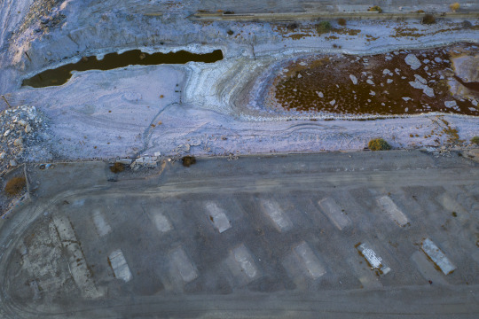
Image: David McNew/Getty Images
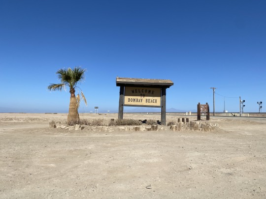
The Salton Sea was once a resort area, with a series of small towns and vacation spots on its coasts. It is now so toxic that few creatures can live in its waters, though it is still an ecologically important area for migratory birds. Some of the towns, such as Bombay Beach, have essentially become ghost towns over the past few decades.
Chemicals like arsenic, selenium, and pesticides are rampant in the lake’s waters, and their particles have been released into the atmosphere as it dries, which is happening at an increasing rate as drought grips the west coast. Communities around the sea have long felt the burden of pollutant exposure; asthma-related emergency room visits are more than double the state average and nearly a third of children experience respiratory symptoms like wheezing, allergies, and dry cough, medical surveys have found.
So, ramping up mining in one of the state’s most polluted counties—where 85 percent of residents are Hispanic or Latino and 22 percent live under the poverty line—feels risky to environmental justice organizers like Miguel Hernandez, communications coordinator at Comité Cívico del Valle. Hernandez hopes to see producers and local legislators make an effort to inform residents about the possible, yet-mostly-unknown health effects of lithium mining, which is water-intensive and produces a fair amount of mineral waste. The concerns pollution researchers like Katie Burnworth, who monitors the Salton Sea for the Imperial County Air Pollution Control District.
“It’s a dangerous, dirty process, with a lot of unknown material,” Burnworth told the California Desert Sun in February.
So far, Hernandez says, this educational effort has yet to happen.
“We actually go out there and knock on doors,” Hernandez said. “For those families that I've been able to talk to, it's either little to no information has been shared to them, or they just have what's out there by the media.”
Beyond California, lithium mining across the country has garnered widespread controversy in recent months. A proposed mine in Nevada, called Thacker Pass, was the site of protest in the Spring from local Indigenous communities and environmentalists who feared mining could deplete the already-dry region’s water stores, generate waste and emit thousands of tons of carbon dioxide.
All of that said, absent a massive degrowth movement that significantly reduces the amount of energy society uses, many experts believe we need lithium to decarbonize. Proponents of lithium mining say it is less environmentally destructive than mining for oil and coal, but it's also not good for the environment, and, broadly speaking, lithium mining uses a lot of water. The American southwest is already facing intense water shortages and drought, though the lithium in the Salton Sea is already in brine form.
Kyle Wiens, CEO of iFixit, a technology repair company that seeks to extend the life of electronics, believes mining of any kind is inherently harmful, and “one of the worst things that we do as a species.”
“There is incredible environmental destruction that comes from it,” Wiens said.
But few extraction projects have Wiens—who says he devotes much of his time at iFixit to thinking about the depletion of nonrenewable resources—as optimistic as this one. The idea of using existing energy production to create something that would otherwise be shot back into the ground feels “pretty darn promising,” he says, noting that putting that effort toward a resource that would fuel the transition away from oil and gas is worthwhile.
“This to me seems like a perfectly common sense win-win situation,” Wiens says. “We don't have to dredge the desert … it's already in this liquid that we're circulating [for geothermal energy] anyway.”
Indeed, this argument is at the center of what’s splintered environmentalists about the hunt for lithium, among other minerals required to create solar panels, wind turbines and batteries. Some believe mining is a necessary evil and a requisite in the transition to renewables; others fear this is a bandaid for the broader issue of overconsumption, and say maintaining an extraction-based economy will not do enough to curb climate change. (Wiens, for his part, takes solace in seeing a broadening cohort of startups recycling lithium in batteries, which only became lucrative at scale recently, as the number of electric vehicles on the roads has shot up).
In a press release, CTR said that “The integration of direct lithium extraction with renewable geothermal energy offers the highest sustainability credentials available today. CTR’s closed-loop, direct lithium extraction process utilizes renewable power and steam – significantly reducing the time to produce battery-grade lithium products and eliminating the need for overseas processing. CTR’s operations will have a minimal physical footprint and a near-zero carbon footprint. The brine, after lithium extraction, is returned to the geothermal reservoir deep within the earth.” CTR provided the press release in response to a Motherboard request for comment.
Bringing job opportunities to a region with unemployment rates that have historically hovered around 20 percent could also flush cash into projects that need it badly, like pollution mitigation, education, infrastructure and healthcare, Wiens notes. Rodriguez echoes that belief, but isn't ready to get too excited. A recent solar buildout in Imperial County saw massive land use with little economic gains for the region because of tax exemptions and a slew of jobs handed to outsiders, he says.
Rodriguez would like to see local jobs and training programs come out of the CTR contract—an ask that’s still up in the air as the producer undergoes permitting processes. Ryan Kelly, representative of the district that’s home to the Salton Sea on the Imperial County Board of Supervisors, says this is a concern, one that he’s yet to broach with GM.
But as vice chair of the Lithium Valley Commission (a governing board Gov. Gavin Newsom created last September devoted to guiding the buildout of mining opportunities in the region), Kelly is currently fighting to pass an ordinance that would place a levy on the mineral, securing income from the mines for local projects like schooling and infrastructure.
Made up of representatives from industry, government, environmental groups, and community advocacy organizations like Hernandez’s, the commission’s goal is to facilitate conversation around economic and environmental concerns, and to draft a set of recommendations for the sector as it emerges in southern California.
“What community-based organizations want to know is how are these large companies going to play a part in our community?” Kelly said. “What are they going to give back for what they take?”
Indeed, Hernandez says having a seat at the table is heartening for Comité Cívico del Valle. “I think this is the first, or one of the first opportunities that the community is able to be represented in these situations,” he notes.
But the commission’s framework is non-binding, meaning, once they pass an environmental impact review, companies like CTR do not have to follow the recommendations. Kelly is hopeful that this won’t be an issue (“Maybe I'm being a little too optimistic, but so far we haven't had any arguments,” he said, of the commission, with a laugh.)
Hernandez is hopeful, too—but he believes the next stages of approval in GM’s contract will be telling.
“I'm not against the industry, or any industry, but I'm a huge advocate for doing things right,” Rodriguez says. “Let's assume it's gonna be part of our communities. Then, let's make lithium a good neighbor.”
Motherboard reached out to representatives at General Motors but we did not hear back.
An Incredibly Toxic Lake Will Become One of the US’s First Lithium Mines syndicated from https://triviaqaweb.wordpress.com/feed/
0 notes
Text
HAS THE ILLEGAL OCCUPATION OF HAWAI`I WORKED?
How Land Schemes Turned Lava Fields Into Subdivisions
Honolulu Civil Beat - May 14, 2018
In 1958, when Hawaii statehood was still a year away, two Colorado businessmen came up with a brilliant money-making scheme: Buy 12,000 acres of undeveloped, dirt-cheap land on the rocky, rainy slopes of the world’s most active volcano, divide it into 4,000 3-acre lots, and sell them for $500 to $1,000 apiece, paid off at $150 down and $8 a month.
Glen Payton and David F. O’Keefe called their subdivision “Hawaiian Acres.” It would forever change the face of the Big Island — not always for the better.
“The lots sold spectacularly well,” wrote George Cooper and Gavan Daws in Land and Power in Hawaii. “The effect of this success was electrifying.”
A Big Island land boom was on.
Only two years after Hawaiian Acres lots went on sale, a Honolulu Star-Bulletin article could report that at least 11 major subdivisions were underway — including a cluster of 2,231 one-acre lots titled “Leilani Estates,” sited directly on top of Kilauea’s East Rift Zone. The article was headlined, “Here’s Up-to-Date Report on Big Island Subdivisions,” but above the headline were five words in smaller type: “There’s Little Danger from Volcanoes.”
In the article, Leilani developer Kenneth W. Ing claimed that “volcanic risk” to his development was essentially less than one in a thousand.
He based his claim on calculations by a University of Hawaii geology professor, Dr. Gordan MacDonald, who had said that since 1750, lava had covered only 20 square miles out of an east Puna area of 125 square miles: “On this basis, the likelihood of lava covering any given plot of land in any single given year is less than .1 percent.”
Since 1960, lava flows from the flanks of Kilauea have wiped out the town of Kapoho and at least four other communities. But the article also quotes MacDonald as saying, “It is impossible to say how soon volcanic activity might affect any given area, and data are insufficient to assign any significant mathematical probability for such an event.”
What MacDonald, Ing and the article failed to mention was that in January and February of 1960, a lava flow had wiped out the entire town of Kapoho, destroying the village’s businesses, a hot springs resort and nearly 1,000 homes on land adjacent to Ing’s new subdivision—or that in 1955, another eruption had taken out much of nearby Pohoiki.
Since then, lava has obliterated at least four more nearby communities and subdivisions: Royal Gardens, Kapa’ahu, Kaimu and Kalapana.
Now, it’s the turn of Leilani Estates itself, which so far has lost 36 structures, including at least 26 homes, to the latest East Rift lava event.
As of Sunday more than 2,000 people have been evacuated from Leilani Estates, Lanipuna Gardens and other nearby locations. Underground magma is believed to be moving further down the rift, threatening other communities such as Kapoho, parts of which have been redeveloped since the 1960 eruption into three coastal subdivisions, Kapoho Beach Lots, Kapoho Farm Lots and Kapoho Vacationland.
Those who live in the subdivisions aren’t the only ones who’ve had to leave. County officials have directed the closure of the Lower Puna’s numerous vacation rentals, in order to save water and “reduce the area population so emergency operations can focus on residents.”
Affordable Homes — At A Price
Cooper and Daws note that by the time the Big Island land boom wound down in the 1970s, 80,000 new lots had been created on an island that, at that time, held only 80,000 people.
Then-Gov. John Burns spearheaded the drive to transform North Kona and North and South Kohala into what Burns called a “gold coast.” It remains a region of rich resorts and upscale homes. Other developers pumped money into resort hotels along Hilo’s Banyan Drive.
But Puna and Kau became a playground for the wannabe-rich. Those three districts, located on the slopes of Mauna Loa and Mauna Kea, lacked the Gold Coast’s white sand beaches and relentlessly sunny weather. And those pesky eruptions kept making new land — but it was lava and volcanic ash, too hard and raw to be paradise.
Mainland investors and mainland buyers didn’t necessarily know that, however. The developments that grew up there are still sometimes known, locally, as “land scam subdivisions.”
Pam Frierson, in The Burning Island, compares those developments to similar ones that were sprouting up elsewhere in America’s sunbelt, from Florida to the Southwest: “Large scale speculative subdivisions were being carved out of marginal lands — desert, tidal flats, lava lands — and sold as cheap ‘retirement’ or ‘investment’ properties.”
Most of these subdivisions were “substandard,” having a grid of private roads that didn’t meet county building codes — perhaps paved, perhaps not — and lacking basic services such as running water and sewer lines.
Many eventually joined the island’s power grid, but most still rely on rainwater catchment tanks, and on cesspools or septic tanks to dispose of waste. They also lacked visible means of financial support. Most were located far from jobs. Though usually zoned agricultural, they were carved into parcels too small for conventional farms, even if they actually had tillable soil. Some subdivisions had a general store, but there was no traditional town center, no hub of commerce.
County officials had a huge incentive to go along with the land schemers: a windfall in property taxes from those thousands of new lots. In 1987, Frierson asked then-Hawaii County Planning Director Albert Lono Lyman why the county had acquiesced to all those substandard subdivisions.
“Greed and short-sightedness,” he summarized, noting that “the majority of those lots were sold, sight unseen, to mainland buyers.”
Some subdivisions were the work of mainland investors. California oil company magnate Jack Crawford, for instance, built Ocean View Estates on old lava flows in Kau.
But there were plenty of local players, including state officials. Hawaii County police inspector William Kamau headed the hui that tried to build a failed subdivision called Crescent Acres. State Sen. Kazahisu Abe headed the Hilo Development Inc., which developed Orchid Isle Estates in Puna. U. S. Sen. Hiram Fong was president of the company responsible for a development called Fern Estates.
Nor was the greed limited to local bigwigs. Cooper and Daws estimated that one in four Big Island families invested in lots. Big Island money in the lots was dwarfed, though, by outside investments: 12 percent of the lots bought by 1975 were by Big Islanders, 35 percent by Oahu residents, and most of the rest by mainlanders.
With almost no provisions for basic infrastructure, the original investors didn’t appear to actually believe people would live on those lots. But thousands of people proved them wrong.
By the time the subdivision boom finally petered out in the 1970s — partly as a result of stronger zoning and planning ordinances, but also, perhaps, because of the sheer glut of undeveloped lots — East Hawaii held at least 15 major substandard subdivisions and several smaller ones — all of them located in Lava Risk Zones 1, 2 or 3, the three highest-risk categories given by the U.S. Geological Survey.
One cluster of subdivisions, including Hawaiian Ocean View Estates and Hawaiian Ranchos, clung to the lava field on the steep southern end of Mauna Loa. But most were in Puna, forming an almost continuous line from Volcano down Highway 11 to Keaau, then from Keaau down Highway 130 to the sea at the eastern end of the island.
Some built in the subdivisions because they’d been suckered in and had to roll with the punches. Frierson interviewed Jack and Patty Thompson, who were among the last holdouts in volcano-ravaged Royal Gardens. They’d invested their life savings in their home, after seeing a promotional movie about a “fertile area directly adjacent to Hawaii Volcanoes National Park.”
“They didn’t tell you the place sat right below an active rift zone,” Jack Thompson told Frierson.
With the possible exception of Royal Gardens, which was wiped out by a series of lava flows between 1983 and 2012, every one of those subdivisions is inhabited — and many, especially those in lower Puna, are burgeoning, despite the lava risk and the lack of amenities.
They’re the main reason why Puna is the fastest-growing district on the island. According to the Hawaii County General Plan, the district held about 31,300 people in the year 2000.
By 2015, its population had soared to nearly 50,000. By 2020, it’s expected to reach 58,000, surpassing Hilo to become the island’s most populous district. It’s achieved that remarkable growth despite the loss of four communities to molten rock.
Many more came because land speculation had driven prices sky-high in more desirable locations, and companies building those Kona mega-resorts hadn’t made provisions for housing their workers.
The island ended up with much of its jobs on one side of the island and its affordable housing on the other side, generating another local term: the “5 o’clock derby,” for the early morning commute between Puna or Kau and the North Kona/Kohala resorts.
“Poor people have to live somewhere,” noted one Puna Facebook user.
Many of these later buyers know about the lava, but they have to live with the risk, gambling that Madame Pele won’t come to their homes during their particular lifetimes.
But the odds may be considerably worse than Dr. MacDonald predicted back in 1960. According to the USGS, in the 20 years between 1983 and 2003 alone, another 40 square miles were buried in fresh layers of lava.
5 notes
·
View notes
Link
Excerpt from this Washington Post story:
President Trump last month quietly issued an executive order that would dramatically increase logging on public land.
The order, designed to prevent deadly wildfires and issued without much fanfare the Friday before Christmas, has tremendous implications, as my colleagues Darryl Fears and Juliet Eilperin report: "The executive order instructs the secretaries of agriculture and interior to consider harvesting a total of 4.4 billion board feet of timber from forest land managed by their agencies on millions of acres, and put it up for sale. The order would translate into a 31percent increase in forest service logging since 2017."
“In addition to removing trees, Trump asked his secretaries to remove forest brush and debris that help fuel fires from more than 4 million acres and treat another 1.5 million acres to control tree-destroying pests. The order, published last week in the Federal Register, does not specify a deadline to accomplish the president’s goal,” they write in a story published this morning.
This approach doesn’t make sense to some experts: “University of Colorado Bolder Professor Jennifer Balch said in an email that while treating federal forests makes sense near homes, that policy prescription won’t make a serious dent in the size and intensity of wildfires out West. The number of these fires have increased five-fold since the 1970s as temperatures have risen and snowpack has shrunk. Just 2 percent of lands treated by the Forest Service between 2004 and 2013 experienced a wildfire.”
Another notable nugget: The Trump administration is pushing for the logging to continue even though the partial government shutdown has closed the Forest Service. “[O]fficials there have given harvesters permission to keep operating on existing sales — which was prohibited during both the 1995 and 2013 shutdowns — and are now exploring holding new auctions even if the government remains closed,” my colleagues write.
5 notes
·
View notes
Last Seen Blogs

theentertainmentnut
The Entertainment Nut

novatorio
Novator.io

joesbrownusa
Real Estate News

good-doctor-schneeplestein
I am the Good Doctor

myeverydayadventures
Everyday Me