#cincymapcollection
Explore tagged Tumblr posts
Visit Tumblr Blog
Explore Tumblr blogs with no restrictions, modern design and the best experience.
Last Seen Tumblr Blogs


Fun Fact
The Tumblr app for Google Glass was released on May 16, 2013.
Photo

— 𝐯𝐢𝐞𝐰 𝐨𝐟 𝐂𝐢𝐧𝐜𝐢𝐧𝐧𝐚𝐭𝐢, 𝐎𝐡𝐢𝐨, 𝐜.𝟏𝟖𝟕𝟔 This view of the Queen City was published in the June 24th, 1876 issue of Harper’s Weekly. It illustrates a bustling river town from a perspective near the overlook at Devou Park in Covington, KY. For additional imagines of this print of Cincinnati and others visit the @cincymapcollection website linked in the Bio. #ohio #cincinnati #cincinnatihistory #print #cincymapcollection #ohioriver #view #historiccincinnati #devoupark #covingtonky #harpers https://www.instagram.com/p/CM-KYGrBT5q/?igshid=1qm79mn286zxq
#ohio#cincinnati#cincinnatihistory#print#cincymapcollection#ohioriver#view#historiccincinnati#devoupark#covingtonky#harpers
1 note
·
View note
Photo

— 𝐂𝐢𝐧𝐜𝐢𝐧𝐧𝐚𝐭𝐢 𝐚𝐧𝐝 𝐈𝐭𝐬 𝐒𝐮𝐛𝐮𝐫𝐛𝐬, 𝐜.𝟏𝟖𝟕𝟓 This map of Cincinnati and Its Suburbs was published in 1875 by M. & R. Burgheim for their 𝘎𝘶𝘪𝘥𝘦 𝘔𝘢𝘱 𝘰𝘧 𝘊𝘪𝘯𝘤𝘪𝘯𝘯𝘢𝘵𝘪. The Burgheim firm was local to Cincinnati with offices at the corner of Vine and Mercer Street. During this era of cartography, it was still common for local publishers to have the most accurate and more detailed maps of the cities in which they were based. M. & R. Burgheim’s maps of the Queen City are especially detailed as evidenced by unique labeling such as the “Refreshments” stand in Eden Park or the Highland House upon the Mt. Adams hillside. Visit the @CincyMapCollection website (linked in bio) for more images of this historical map of Cincinnati and others. #cincinnati #cincymapcollection #maps #ohio #ohiohistory #cincinnatihistory #historicalsociety #cincy #antique #1875 #circa #queencity #cincinnatiohio #burgheim https://www.instagram.com/p/CGhZwvIBfHA/?igshid=10dcll9rq5n4n
#cincinnati#cincymapcollection#maps#ohio#ohiohistory#cincinnatihistory#historicalsociety#cincy#antique#1875#circa#queencity#cincinnatiohio#burgheim
2 notes
·
View notes
Photo

— 𝐏𝐥𝐚𝐧 𝐨𝐟 𝐂𝐢𝐧𝐜𝐢𝐧𝐧𝐚𝐭𝐢 𝐚𝐧𝐝 𝐕𝐢𝐜𝐢𝐧𝐢𝐭𝐲, 𝐜.𝟏𝟖𝟔𝟎 This engraved map of Cincinnati by S. Augustus Mitchell, Jr. is the first edition of many to follow. Originally published in 1860, this detailed map Of the Queen City gives us a superb sampling of the ornate borders that Mitchell’s maps were known for. Many publishers included these decorative borders through the mid-19th century, but the practice seems to have been less popular by the end of the century. Early 20th century publishers continued using patterned borders for their maps, but none compare to the elaborate works of art which came before them. This Civil War era map predates an iconic Cincinnati landmark which was later added to the 1862 version of this map (also found on the website) during its planning and construction — any idea what that landmark might be? #cincinnati #ohio #history #map #1860 #augustusmitchell #queencityhistory #cincyhistory #cincinnatihistory #ohiohistory #cincymapcollection #historiccincinnati https://www.instagram.com/p/CD9azSwBegB/?igshid=1qi4szfmn6p8g
#cincinnati#ohio#history#map#1860#augustusmitchell#queencityhistory#cincyhistory#cincinnatihistory#ohiohistory#cincymapcollection#historiccincinnati
1 note
·
View note
Photo

— 𝐌𝐞𝐝𝐢𝐜𝐚𝐥 𝐂𝐨𝐥𝐥𝐞𝐠𝐞 𝐨𝐟 𝐎𝐡𝐢𝐨, 𝐂𝐢𝐧𝐜𝐢𝐧𝐧𝐚𝐭𝐢, 𝐜.𝟏𝟖𝟓𝟏 The original buildings that housed Ohio’s first medical school no longer exist, but the program is still alive and well in the Queen City. Founded in 1819, the present-day Cincinnati College of Medicine is one of the oldest medical schools in the country. Today the Cincinnati College of Medicine held a virtual ceremony for the graduating MedCat Class of 2020. Another first for the historic medical program. Congratulations! #MedCatClassof2020 Visit the @CincyMapCollection website (linked in bio) for more historical maps and prints of Cincinnati. #cincinnati #ohio #history #historic #2020 #medcats #classof2020 #prints #maps #cincymapcollection #cincyhistory #medicalhistory #historiccincinnati #medicine #medcats #1851 #collegeofmedicine https://www.instagram.com/p/CAix2CyhjyW/?igshid=15awqxulj4oxm
#medcatclassof2020#cincinnati#ohio#history#historic#2020#medcats#classof2020#prints#maps#cincymapcollection#cincyhistory#medicalhistory#historiccincinnati#medicine#1851#collegeofmedicine
1 note
·
View note
Photo

— 𝐂𝐞𝐧𝐭𝐫𝐚𝐥 𝐒𝐞𝐜𝐭𝐢𝐨𝐧, 𝐂𝐢𝐧𝐜𝐢𝐧𝐧𝐚𝐭𝐢, 𝐜.𝟏𝟗𝟑𝟖 Published in George Cram’s Atlas, “𝘊𝘪𝘵𝘪𝘦𝘴 𝘢𝘯𝘥 𝘛𝘰𝘸𝘯𝘴 𝘰𝘧 𝘵𝘩𝘦 𝘞𝘰𝘳𝘭𝘥,” this lithographed map shows the Central Section of Cincinnati in 1938. Visit the @CincyMapCollection website linked in bio to view more historical maps and prints of The Queen City. #cincinnati #cincinnatihistory #historicohio #ohiohistory #1938 #queencityhistory #cincyhistory #maps #cincymapcollection #oldmaps #antiques #mapcollection https://www.instagram.com/p/B_KqYXkhDgJ/?igshid=16h12szpc44lb
#cincinnati#cincinnatihistory#historicohio#ohiohistory#1938#queencityhistory#cincyhistory#maps#cincymapcollection#oldmaps#antiques#mapcollection
1 note
·
View note
Photo

— 𝐆𝐞𝐧𝐞𝐫𝐚𝐥 𝐕𝐢𝐞𝐰 𝐨𝐟 𝐂𝐢𝐧𝐜𝐢𝐧𝐧𝐚𝐭𝐢, 𝐜. 𝟏𝟖𝟖𝟖 These views of Cincinnati were published as a supplement to a Harper’s Weekly article written in the June 30th, 1888 titled, “𝘛𝘩𝘦 𝘘𝘶𝘦𝘦𝘯 𝘊𝘪𝘵𝘺 𝘰𝘧 𝘛𝘩𝘦 𝘞𝘦𝘴𝘵.” The article reads as a glowing review of the city and tells the story of Cincinnati’s origins, characteristics and notable accomplishments through the present day. One excerpt reads, “Having passed through all the different stages of growth incidental to the complete establishment of an American city, and having arrived at that point where material advancement is no longer made the chief aim of the city’s existence, Cincinnati has thus become an excellent type of the foremost civilization of the West.” Also included in this supplemental print are notable structures, several of which are the homes of prominent citizens. The Harper’s article states that “The Cincinnati man’s love for a fine house in a good location has given the city the best suburbs in the country” and “Nearly all the handsome houses are on the bluffs. Some of them overlook the city itself, while others get a glimpse of a quiet view extending miles up the river.” A link to the full text found in the Harper’s Weekly article can be found on the @cincymapcollection website. #cincinnati #harpersweekly #cincymapcollection #prints #queencity #history #cincinnatihistory #1888 @harpersmagazine #historichomes #oldhouse #historicalarchitecture #cityviews #birdseyeview #historiccincinnati #historicohio https://www.instagram.com/p/B8WggdBhhR0/?igshid=6ruw42uur1m5
#cincinnati#harpersweekly#cincymapcollection#prints#queencity#history#cincinnatihistory#1888#historichomes#oldhouse#historicalarchitecture#cityviews#birdseyeview#historiccincinnati#historicohio
1 note
·
View note
Photo
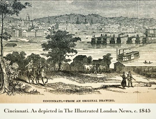
— 𝐂𝐢𝐧𝐜𝐢𝐧𝐧𝐚𝐭𝐢, 𝐜.𝟏𝟖𝟒𝟓 This scene of Cincinnati was published in 1845 by the world’s first weekly news magazine – 𝘛𝘩𝘦 𝘐𝘭𝘭𝘶𝘴𝘵𝘳𝘢𝘵𝘦𝘥 𝘓𝘰𝘯𝘥𝘰𝘯 𝘕𝘦𝘸𝘴. One excerpt from the article describes the attractiveness of the “pretty villas” which is amplified by the “culture of trees and flowers, and the laying out of well-kept gardens, the sight of which, to those who walk along the streets, is inexpressibly refreshing and agreeable.” The columnists goes on to say “I was quite charmed with the appearance of the town, and its adjourning suburb of Mount Auburn; from which the, lying in an amphitheatre of hills, forms a picture of remarkable beauty, and is seen to great advantage.” It seems the London-based author of this article was quite impressed with The Queen City of the American West. To see more #historical views of #Cincinnati, visit the @cincymapcollection website linked in the bio. #cincinnatihistory #prints #views #ohioriver #londoner #queencityscenes #queencity #ohiohistory #rareprints #1845 #historiccity #maps #history #cincymapcollection #newportky #covingtonky https://www.instagram.com/p/B6HnJ8ZhQLo/?igshid=ijxxuvc3gzf2
#historical#cincinnati#cincinnatihistory#prints#views#ohioriver#londoner#queencityscenes#queencity#ohiohistory#rareprints#1845#historiccity#maps#history#cincymapcollection#newportky#covingtonky
1 note
·
View note
Photo

— 𝐍𝐞𝐰 𝐁𝐮𝐬𝐢𝐧𝐞𝐬𝐬 𝐀𝐭𝐥𝐚𝐬 𝐨𝐟 𝐂𝐢𝐧𝐜𝐢𝐧𝐧𝐚𝐭𝐢, 𝐜.𝟏𝟖𝟗𝟖 This map was published in 1898 for Rand, McNally & Co’s 𝘕𝘦𝘸 𝘉𝘶𝘴𝘪𝘯𝘦𝘴𝘴 𝘈𝘵𝘭𝘢𝘴 𝘰𝘧 𝘊𝘪𝘯𝘤𝘪𝘯𝘯𝘢𝘵𝘪 and features a detailed layout of downtown Cincinnati. More images of this historical map of Cincinnati, and others, can be found on the @CincyMapCollection website linked in the bio. #CincyMapCollection #Maps #Cincinnatihistory #ohiohistory #cincinnati #queencity #randmcnally #1898 #cincyhistory https://www.instagram.com/p/B51R8HwhQEe/?igshid=10bju9ki7r1pl
#cincymapcollection#maps#cincinnatihistory#ohiohistory#cincinnati#queencity#randmcnally#1898#cincyhistory
1 note
·
View note
Photo

— 𝐌𝐚𝐩 𝐨𝐟 𝐂𝐢𝐧𝐜𝐢𝐧𝐧𝐚𝐭𝐢, 𝐜.𝟏𝟗𝟎𝟒 This detailed map of Cincinnati was published by The Americana Company for 𝘌𝘯𝘤𝘺𝘤𝘭𝘰𝘱𝘦𝘥𝘪𝘢 𝘈𝘮𝘦𝘳𝘪𝘤𝘢𝘯𝘢 in 1904. Interestingly, this map identifies the modern-day The City of Norwood as “Idlewild” and “Ivanhoe.” While the origins of how the name Norwood came to be, there is hardly any mention of the name Ivanhoe for this northern suburban community other than the name of a street which still exists today as Ivanhoe Avenue. The most commonly held belief for how today’s 2nd largest city within Hamilton County Ohio received its name is thought to be due to the northern positioning of the once wooded area from Cincinnati. By the late 1860’s the area was commonly being referred to as the “North Woods” and would be referenced, in writing, by a Cincinnati Enquirer article dating back to 1870 as Norwood. It is unknown how the name Ivanhoe was chosen by the cartographer of this early 20th century map. To see more images of this map and other historical maps and prints of Cincinnati visit the @cincymapcollection website linked in the bio. #cincinnati #cincymapcollection #maps #prints #norwood #ohio https://www.instagram.com/p/B5WiXLfBHq8/?igshid=1ctc5del030m
1 note
·
View note
Photo

— 𝐏𝐢𝐜𝐭𝐨𝐫𝐢𝐚𝐥 𝐌𝐚𝐩 𝐨𝐟 𝐎𝐡𝐢𝐨, 𝐜. 𝟏𝟗𝟑𝟓 This pictorial map of Ohio was published in 1935 by Little, Brown and Company’s school textbook titled 𝘖𝘶𝘳 𝘜.𝘚.𝘈., 𝘈 𝘎𝘢𝘺 𝘎𝘦𝘰𝘨𝘳𝘢𝘱𝘩𝘺. Ruth Taylor White illustrated all of the maps for the textbook. White was American cartographic illustrator who was know for her pictorial maps from the 1920’s to the 1940’s. This map includes many of her signature bobble-headed cartoon characters who romped through her colorful landscapes. For more images of this pictorial map visit the @cincymapcollection website linked in bio. #cincymapcollection #maps #pictorial #pictorialmap #ruthtaylorwhite #1935 #history #ohio #mapart #cincinnati #southwestohio #columbus #centralohio #cleveland #northeastohio #toledo #northwestohio #daytonhistory https://www.instagram.com/p/B04itFnhLzr/?igshid=gv7fntiyub7k
#cincymapcollection#maps#pictorial#pictorialmap#ruthtaylorwhite#1935#history#ohio#mapart#cincinnati#southwestohio#columbus#centralohio#cleveland#northeastohio#toledo#northwestohio#daytonhistory
3 notes
·
View notes
Photo

— 𝐏𝐢𝐜𝐭𝐨𝐫𝐢𝐚𝐥 𝐌𝐚𝐩 𝐨𝐟 𝐎𝐡𝐢𝐨, 𝐜. 𝟏𝟗𝟑𝟏 This pictorial Map of Ohio was published in 1931 for Vernon Quinn’s 𝘗𝘪𝘤𝘵𝘶𝘳𝘦 𝘔𝘢𝘱 𝘎𝘦𝘰𝘨𝘳𝘢𝘱𝘩𝘺 𝘰𝘧 𝘵𝘩𝘦 𝘜𝘯𝘪𝘵𝘦𝘥 𝘚𝘵𝘢𝘵𝘦𝘴. The Maps in Quinn’s book were drawn by Paul Spencer Johst. Johst artfully livened his map of Ohio with illustrations of the region’s industry, history, buildings, people and animals. In addition, Johst labels the four most populous cities in Ohio: Cleveland (900,429), Cincinnati (451,160), Toledo (290,718) and Columbus (290,564). #cincymapcollection #ohiohistory #pictorial #maps #cincinnati #cleveland #columbus #toledo #buckeyestate #ohiovalley #1931 https://www.instagram.com/p/B0hCRxKB0D2/?igshid=2ffw6si0xcbe
#cincymapcollection#ohiohistory#pictorial#maps#cincinnati#cleveland#columbus#toledo#buckeyestate#ohiovalley#1931
2 notes
·
View notes
Photo

𝐌𝐚𝐩 𝐨𝐟 𝐓𝐡𝐞 𝐒𝐭𝐚𝐭𝐞 𝐨𝐟 𝐈𝐧𝐝𝐢𝐚𝐧𝐚 𝐚𝐧𝐝 𝐎𝐡𝐢𝐨 𝐰𝐢𝐭𝐡 𝐏𝐚𝐫𝐭 𝐨𝐟 𝐓𝐡𝐞 𝐌𝐢𝐜𝐡𝐢𝐠𝐚𝐧 𝐓𝐞𝐫𝐫𝐢𝐭𝐨𝐫𝐲, 𝐜. 𝟏𝟖𝟐𝟎 This early 19th century map was published by London-based I.T. Hinton & Sinupkin & Marshall. During the time of this map’s publication in 1820 there were several interesting developments occurring within the newly formed states of Ohio and Indiana. Ohio would have recently moved it’s capital to Columbus just four years earlier, after bouncing back-and-forth between Chillicothe and Zanesville for the first decade and a half of the state’s formation. The capital of Indiana would have been Corydon, located only 8 miles off the Ohio River and home to several influential settlers of the territory at that time. Like Ohio, political forces and migration of settlers throughout the state created the need for a more centralized seat of government. Corydon, Indiana would proudly claim the state’s capital for another four years, until 1824, before it would be relocated to Indianapolis. For more images of this map visit the @cincymapcollection website #cincymapcollection #Indianahistory #Ohiohistory #cincinnatihistory #buckeyestate #hoosierhistory #clevelandhistory #queencityhistory #1820s #oldmaps #antiquemap https://www.instagram.com/p/Bxj_dcuF9c4/?igshid=j4vmmnyjjv1a
#cincymapcollection#indianahistory#ohiohistory#cincinnatihistory#buckeyestate#hoosierhistory#clevelandhistory#queencityhistory#1820s#oldmaps#antiquemap
1 note
·
View note
Photo
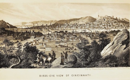
1856 PRINT: BIRDS EYE VIEW OF CINCINNATI — This rare print was published by Charles Mangus in 1856. Mangus was a New York-based map dealer, book seller and print publisher who is best known for his publications of civil war era prints and city views. It was at this time in the Queen City’s history that construction on one of it’s most notable landmarks would have commenced. From this view, a bridge connecting Cincinnati and northern Kentucky is noticeably absent. As depicted in this city view, the Cincinnati area was a bottleneck on the Ohio River due to overcrowded waterways by riverboats, barges and ferry boats. This economic constraint was the driving factor in securing funding for John Roebling’s suspension bridge. - - #cincymapcollection #cincinnati #ohioriver #birdseyeview #1856 #history #ohio #covington #newport #northernky #prints (at Cincinnati) https://www.instagram.com/p/Bpcu7Gpl9eq/?utm_source=ig_tumblr_share&igshid=1q9kf7nidwpha
#cincymapcollection#cincinnati#ohioriver#birdseyeview#1856#history#ohio#covington#newport#northernky#prints
7 notes
·
View notes
Photo

#tbt #cincinnati #history These illustrations of the old Cincinnati Public Library in the March 21st, 1874 issue of Harper’s Weekly are incredible. It was due to world-class institutions such as this that Cincinnati upheld its reputation as “The Queen City of the West” throughout the 19th century. The Harper’s Weekly feature article starts off by stating that “Cincinnati possesses the largest, best-arranged, and only fire-proof public library building in the country.” The article goes on to describe the quality of the contents as “the largest and best collection of books west of the Alleghanies” and further notes that “the Western cities are overshadowing the Eastern in this sort of enterprise.” Keep in mind, Harper’s Weekly was one of the premier national publications at the time, so I imagine their opinion would carry some weight in these matters. #cincymapcollection https://www.instagram.com/p/Bn8eESsB96t/?utm_source=ig_tumblr_share&igshid=odkuahi8q0r2
1 note
·
View note
Photo

—𝐓𝐡𝐞 𝐂𝐢𝐭𝐲 𝐨𝐟 𝐂𝐢𝐧𝐜𝐢𝐧𝐧𝐚𝐭𝐢, 𝐜. 𝟏𝟖𝟓𝟓 This engraved map of Cincinnati was published in 1855 by Joseph Hutchins Colton. Colton was born in Massachusetts but moved to New York in the 1830’s where he established J.H. Colton & Co, a publishing company known for their detailed maps, atlases and travel guides of mostly American cities. 1855 was a rather tumultuous year for Cincinnati. Marred by rioting and bloodshed due to a highly contested mayoral election as well as tensions between anti-catholic and anti-immigrant “nativists” and Cincinnati’s German-immigrant population coming to a boiling point. (Think Martin Scorsese’s 2002 film “𝘎𝘢𝘯𝘨𝘴 𝘰𝘧 𝘕𝘦𝘸 𝘠𝘰𝘳𝘬”) During these riots many of the streets heading north into Over-the-Rhine were barricaded and fortified along the canal shown on this map (present day Central Parkway), only allowing Germans-Americans safe passage into the neighborhood. At one point, a cannon was fired over the heads of an approaching mob of nativists as they attempted to breach one of the barricades. It was a tense period in the Queen City’s history to say the least. For more historical maps and prints of Cincinnati visit the @CincyMapCollection website linked in the bio. #cincinnati #map #ohiohistory #cincinnatihistory #cincyhistory #1855 #cincinnatiriots #history #maps #cincy #queencityhistory #queencity #cincymapcollection https://www.instagram.com/p/CDdiORAhA3Y/?igshid=xid0qg5jijyh
#cincinnati#map#ohiohistory#cincinnatihistory#cincyhistory#1855#cincinnatiriots#history#maps#cincy#queencityhistory#queencity#cincymapcollection
0 notes
Photo

— 𝐅𝐢𝐫𝐞-𝐄𝐧𝐠𝐢𝐧𝐞 𝐚𝐭 𝐂𝐢𝐧𝐜𝐢𝐧𝐧𝐚𝐭𝐢, 𝐜.𝟏𝟖𝟖𝟓 This image of a Cincinnati “Fire-Engine” hurrying to the scene of a large fire off in the distance was published in a London news paper in 1885. In the mid-19th century the City of Cincinnati was world renowned for it’s firefighting efforts. In fact, according to The Cincinnati Fire Museum Association, it was here in 1853, that the nation’s first paid professional fire department was created by law, and its organizational plan became a model for other cities across the country. For more images of this historical print of Cincinnati and others, view the @cincymapcollection website linked in the bio. 🔥📣👨🚒🚒 #cincymapcollection #cincinnatihistory #ohiohistory #firefightersofinstagram #firefighters #history #firstresponders https://www.instagram.com/p/B5jXsUrhfOU/?igshid=1wzhgh1rw2mlb
#cincymapcollection#cincinnatihistory#ohiohistory#firefightersofinstagram#firefighters#history#firstresponders
0 notes