#cooleman
Text
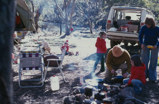
Cooking breakfast over an open fire.
Cooleman, New South Wales
1977
#vintage camping#campfire light#cooleman#new south wales#australia#road trips#camping#history#family#1970s
202 notes
·
View notes
Photo
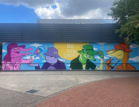
Just like Wu-Tang, this mural is for the children. Also adults. Really anyone with skin. . A new mural painting this past weekend down at @coolemancourt Weston for @cancercouncil_act all about the importance of both kids and parents Slipping Slopping Slapping Seeking and Sliding. . #slipslopslapseekslide #weston #canberramural #canberra #houlart #houl (at Cooleman Court Shopping Centre) https://www.instagram.com/p/CpzWy3XBM08/?igshid=NGJjMDIxMWI=
2 notes
·
View notes
Text
Lecture: Introduction to Art and Research (by Joyce Hinterding) (1.8.23)
Artistic practice is, by nature, interdisciplinary (research is crucial).
Art+ Energy:
Energy can manifest in different forms (sound, light, kinetic, electric, chemical, etc.), causing change.
First law of thermodynamics: “Energy can neither be created nor destroyed, it can only be transformed.” Examples below:
Hans Haacke’s Condensation Cube (1965)
David Haines’ The Wollemi Kirilians (2014) and Slow Fast Mountains (Earth Aroma) (2014)
Joyce Hinterding’s Aeriology (1995-2001)
Second law of thermodynamics: “a natural process runs only in one direction and is not reversible.” Associated with entropy, which is essentially the change from order to chaos. Examples below:
Amanda Williams’ Cooleman Plain Karst, Kosciuszko National Park, (know who you are at every age) (2017-2018)
Seung-Hwan Oh’s Impermanence_Untitled series (2012-2015)
Other examples (tangentially related to screen arts?):
RIXC’s (Latvia’s Centre of New Media Culture, for new media, art, film, etc.) video installation RT-32 - Acoustic Space Lab (originally 2002, newer version in 2006), by Rasa and Raitis Šmits
David Haines and Joyce Hinterding’s sound-video installation Geology (2015)
Martin Howse’s work explores the idea of speculative hardware (i.e. the concept of an ‘earth computer’), linking geology, coding, sound and the human psyche.
Reflection: I’ve realised I have done this in the past multiple times with previous projects. So I’m looking forward to it.
0 notes
Text
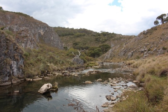
High Country - Cooleman Caves
The benefit of having the OzTent is the speed of which it sets up and packs down. This morning made our lives super easy as we had our coffee and breakfast and packed up the tent in only a few minutes. I drove us back up the steep Gentle Annie Trail back to the main track where D took over and drove us to the next destination. She has certainly come a long way in her manual driving skills and i was really proud of how well she drove the Broken Cart Track down to Long Plain Road and in to Cooleman Mountain Camping Area and down to the Blue Waterholes.
We passed through several camping areas which started off empty and got busier as we approached the Waterholes. We parked up and stretched our legs with a walk down to the caves. We managed 3 of the river crossings on stepping stones, before the 4th one meant us removing our boots and socks and braving the cold water. We decided to keep warm and turn around, happy with what we had seen.
We decided to go back to the first camp area which was deserted, happy again to be alone and away from other campers. We saw plenty of trailer and caravans head on past towards the crowds and we held our breath each time hoping to keep the site to ourselves. A bit later in the afternoon we got some rain, so we quickly rigged up the awning and side panels and managed to cook our dinner and relax in the dry. Again the OzTent worked perfectly and came together in a couple of minutes with little effort.
Once the rain passed we explored our camp ground and found lots of firewood left in other fire pits, so i gathered it up and had us a fire near our tent. It was great to add a little warmth, and i was able to use our new Biji Barbi for the first time. Very impressed with how easy it is to cook on and i am looking forward to many more meals on it.
Definitely feeling colder tonight.


1 note
·
View note
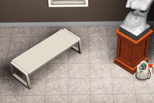
Photo


Six loveseat benches massaged from EA coffee tables. Mesh height adjusted so no clipping. Variable prices and comfort. All can be found in miscellaneous comfort. All have custom thumbnails.

Cooleman Pair §120, 5 Comfort. Room categorised for outdoor seating and pool. Pets cannot go under. No stencils. 3 presets, 4 channels.
DOWNLOAD (185KB)

Optimistic Traveler §235, 10 Comfort 4 Environment. Room categorised for living room seating. Pets cannot go under. No stencils. 3 presets, 4 channels.
DOWNLOAD (263KB)
Your Inheritance §190, 5 Comfort. Room categorised for living room seating. Pets cannot go under. No stencils. 3 presets, 4 channels.
DOWNLOAD (143KB)

Murphy's Sunset §145, 5 Comfort. Room categorised for outdoor seating and pool. 3 presets, 3 channels.
DOWNLOAD (170KB)
The Institution §160, 15 Comfort. Room categorised for kids furniture. 3 presets, 2 channels.
DOWNLOAD (97KB)
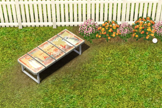
Reclaimation Declaration §295, 18 Comfort, 7 Environment. Room categorised for outdoor seating. 4 presets, 3 with stencils, 4 channels.
DOWNLOAD (457KB)
Suggested Additions
Sandy's seat height cushions (hold down alt to finetune them into place as they're footprinted for a normal chair with a back)
icarus_allsorts's transmogrifier (I purposely adjusted the comfort on these benches low so sims wouldn't travel halfway across your lot to sit in them as the chairs I originally cloned had very high comfort rating. if you WANT them to, merely copy the script from a more comfortable loveseat in buy mode and paste it onto the bench. this mod is useful for a multitude of things besides this, I could write a book.)
166 notes
·
View notes
Photo
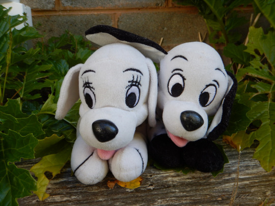


Disney - 102 dalmations - Oddball and Little dipper plush beanbag toys
Features: Are soft toys full of plastic pellets, they both originally come with a felt pendant around their collar (The little dipper one is a bone).
- Little dipper has a fault where the spots fade with use. We had to redraw them on with permanent marker a few times because he was so well loved.
- The last one in this set is Domino.
Size: 24cm long (Small plush)
Date: 2000 or 2001, unsure
Obtained: Little dipper was from Jamison markets long ago, Oddball was found at the playground with a torn back, later picked up another one from the second hand shop in Cooleman court before it moved out.
#Disney plush#Disney bean bag plush#Oddball plush#Little dipper plush#Disney little dipper plush#Disney oddball plush#Oddball bean bag#Little dipper bean bag#Puppy#Puppies#Puppy plush#Cute plush#Disney 102 dalmations#102 dalmations#Disney 102 dalmations plush#Disney 102 dalmations plush Oddball#Disney 102 dalmations plush Little dipper#Disney toy#Disney toys#Disney#Oddball#Little dipper#Plush#Plushie#Plushies#Toy#Toys#Stuffed toy#Soft toy#Stuffed animal
22 notes
·
View notes
Photo

Morning sun on the mountains, Cooleman Ridge, ACT, Australia [6000x4000] [OC].
#travel#traveling#world#asia#africa#japan#india#dubai#vocation#adventure#hotel#motel#cheap flights#cheap tickets#expedia flights#airline tickets#china airlines#air ticket#travel agency#cheap airline tickets#cheap air tickets#cheap air#cheap airfare#cheap o air#cheap plane tickets#airplane ticket#travel sites#airline flights#travel websites#travel deals
2 notes
·
View notes
Text
What Is Casino Nsw Postcode

Australian postcodes have four digits; many envelopes for posting within Australia show this.
Casino Nsw Postcode
Mosman Nsw Postcode
Jan 11, 2019 2469 postcode in New South Wales (near Lismore) with map, local transport and hotel information and nearby attractions. Postcode 2469 - New South Wales (near Lismore) - Postcodes. SEIFA 2016 by New South Wales SA1. SEIFA 2016 by Victoria SA1. SEIFA 2016 by Queensland SA1. SEIFA 2016 by South Australia SA1. SEIFA 2016 by Western Australia SA1. SEIFA 2016 by Tasmania SA1. SEIFA 2016 by NT, ACT and Other Territories SA1. SEIFA by State Suburb Code (SSC).
Postcodes are used in Australia to more efficiently sort and route mail within the Australian postal system. Postcodes in Australia have four digits and are placed at the end of the Australian address. Postcodes were introduced in Australia in 1967 by the Postmaster-General's Department and are now managed by Australia Post, and are published in booklets available from post offices or online from the Australia Post website.
Australian envelopes and postcards often have four square boxes printed in orange at the bottom right for the postcode. These are used when addressing mail by hand for Australian delivery.
4Allocation
History[edit]
Postcodes were introduced in Australia in 1967 by the Postmaster-General's Department (PMG) to replace earlier postal sorting systems, such as Melbourne's letter and number codes (e.g., N3, E5) and a similar system then used in rural and regional New South Wales. The introduction of the postcodes coincided with the introduction of a large-scale mechanical mail sorting system in Australia,[1] starting with the Sydney GPO.
By 1968, 75% of mail was using postcodes, and in the same year post office preferred-size envelopes were introduced,[1] which came to be referred to as “standard envelopes”.
Postcode squares were introduced in June 1990[2] to enable Australia Post to use optical character recognition (OCR) software in its mail sorting machines to automatically and more quickly sort mail by postcodes.
Format[edit]
Australian postcodes consist of four digits (three in the Northern Territory [3]), and are written after the name of the city, suburb, or town, and the state or territory:
Mr John Smith
100 Citizen Road
BLACKTOWN NSW 2148
When writing an address by hand, and a row of four boxes is pre-printed on the lower right hand corner of an envelope, the postcode may be written in the boxes.
If addressing a letter from outside Australia, the postcode is recorded before 'Australia'.
Geography[edit]
Australian postcodes are sorting information. They are often linked with one area (e.g. 6160 belongs only to Fremantle, Western Australia). Due to post code rationalisation, they can be quite complex, especially in country areas (e.g. 2570 belongs to twenty-two towns and suburbs around Camden, New South Wales). The south-western Victoria 3221 postcode of the Geelong Mail Centre also includes twenty places around Geelong with very few people. This means that mail for these places is not fully sorted until it gets to Geelong.[citation needed] Some postcodes cover large populations (e.g., postcode 4350 serving some 100,000 people in Toowoomba and the surrounding area), while other postcodes have much smaller populations, even in urban areas. Australian postcodes range from 0200 for the Australian National University (now 2601) to 9944 for Cannonvale, Queensland.
Some towns and suburbs have two postcodes — one for street deliveries and another for post office boxes. For example, a street address in the Sydney suburb of Parramatta would be written like this:
Mr John Smith
99 George Street
PARRAMATTA NSW 2150
But mail sent to a PO Box in Parramatta would be addressed:
Mr John Smith
PO Box 99
PARRAMATTA NSW 2124
Many large businesses, government departments and other institutions receiving high volumes of mail had their own postcode as a Large Volume Receiver (LVR), e.g. the Royal Brisbane and Women's Hospital has the postcode 4029, the Australian National University had the postcode 0200. More postcode ranges were made available for LVRs in the 1990s. Australia Post has been progressively discontinuing the LVR programme since 2006.[citation needed]
Allocation[edit]
Australian states and territories[edit]
The first one or two numbers usually show the state or territory that the postcode belongs to
Casino Nsw Postcode
2-digit postcode areas of Australia
State/TerritoryAbbreviationPostcode rangeNew South WalesNSW1000—1999 (LVRs and PO Boxes only)
2000—2599
2619—2899
2921—2999Australian Capital TerritoryACT0200—0299 (LVRs and PO Boxes only)
2600—2618
2900—2920VictoriaVIC3000—3999
8000—8999 (LVRs and PO Boxes only)QueenslandQLD4000—4999
9000—9999 (LVRs and PO Boxes only)South AustraliaSA5000—5799
5800—5999 (LVRs and PO Boxes only)Western AustraliaWA6000—6797
6800—6999 (LVRs and PO Boxes only)TasmaniaTAS7000—7799
7800—7999 (LVRs and PO Boxes only)Northern TerritoryNT0800—0899
0900—0999 (LVRs and PO Boxes only)
Sometimes near the state and territory borders, Australia Post finds it easier to send mail through a nearby post office that is across the border:
PostcodeLocalityState derived from
Postcode rangesActual State
for this locality4825ALPURRURULAMQLDNT0872ERNABELLANTSA0872FREGONNTSA0872INDULKANANTSA0872MIMILINTSA0872NGAANYATJARRA-GILESNTWA0872GIBSON DESERT NORTHNTWA0872GIBSON DESERT SOUTHNTWA2406MUNGINDINSWNSW and QLD2540HMAS CRESWELLNSWJervis Bay Territory2540JERVIS BAYNSWJervis Bay Territory2611COOLEMANACTNSW2611BIMBERIACTNSW2611BRINDABELLAACTNSW2611URIARRAACTNSW2620HUMENSWACT2620KOWEN FORESTNSWACT2620OAKS ESTATENSWACT2620THARWANSWACT2620TOP NAASNSWACT3500PARINGIVICNSW3585MURRAY DOWNSVICNSW3586MALLANVICNSW3644BAROOGAVICNSW3644LALALTYVICNSW3691LAKE HUME VILLAGEVICNSW3707BRINGENBRONGVICNSW4380MINGOOLAQLDNSW4377MARYLANDQLDNSW4385TEXASQLDNSW and QLD
Some of the postcodes above may cover two or more states. For example, postcode 2620 covers both a locality in NSW (Gundaroo) as well as a locality in the ACT (Hume), and postcode 0872 covers a number of localities across WA, SA, NT and QLD.
Three locations (Mingoola[4], Mungindi[5] and Texas[6]) straddle the NSW-Queensland border (so same town name and postcode on both sides).
Jervis Bay Territory, once an exclave of the ACT but now a separate territory, is geographically located on the coast of NSW. It is just south of the towns of Vincentia and Huskisson, with which it shares a postcode. Mail to the Jervis Bay Territory is still addressed to the ACT.
The numbers used to show the state on each radio callsign in Australia are the same number as the first number for postcodes in that state, e.g. 2xx in New South Wales, 3xx in Victoria, etc. Radio callsigns pre-date postcodes in Australia by more than forty years.
External territories[edit]
Australia's external territories are also included in Australia Post's postcode system. While these territories do not belong to any state, they are addressed as such for mail sorting:
External territoryPostal statePostcodeNorfolk IslandNSW2899Christmas IslandWA6798Cocos (Keeling) IslandsWA6799
Three scientific bases in Antarctica operated by the Australian National Antarctic Research Expeditions share a postcode with the isolated sub-Antarctic island of Macquarie Island (part of Tasmania):
Antarctic basePostal statePostcodeCasey StationTAS7151Davis StationTAS7151Mawson StationTAS7151
State and territory capital cities[edit]
Each state's capital city ends with three zeroes, while territorial capital cities end with two zeroes. Capital city postcodes were the lowest postcodes in their state or territory range, before new ranges for LVRs and PO Boxes were made available. The last number can usually be changed from '0' to '1' to get the postcode for General Post Office boxes in any capital city (though Perth now uses a different range of postcodes for its GPO Boxes):
CityState/TerritoryStreet AddressGPO Box AddressSydneyNSW20002001CanberraACT26002601MelbourneVIC30003001BrisbaneQLD40004001AdelaideSA50005001PerthWA60006001HobartTAS70007001DarwinNT08000801
Allocation within states[edit]
While the first number of a postcode usually shows the state or territory, the second number usually shows a region within the state. However, postcodes with the same second number are not always next to each other. As an example, postcodes in the range 2200–2299 are split between the southern suburbs of Sydney and the Central Coast and Lake Macquarie regions of New South Wales.
Postcodes with a second number of '0' or '1' are almost always located within the metropolitan area of the state's capital city. Postcodes with higher second numbers are usually located in rural and regional areas. Common exceptions are where towns were rural when postcodes were first introduced in 1967, but have since been suburbanised and incorporated into metropolitan areas, e.g. Penrith, New South Wales has the postcode 2750 and Petrie, Queensland has the postcode 4502.
Within each region with the same second number, postcodes usually get bigger the further one travels from the state's capital city along major highways and railways. For instance, heading north on the North Coast railway in New South Wales away from Sydney:
TownPostcodeDistance from Central StationDungog2420245 km (152 mi)Taree2430378 km (235 mi)Kempsey2440503 km (313 mi)Coffs Harbour2450607 km (377 mi)Grafton2460695 km (432 mi)Casino2470805 km (500 mi)
Major towns and cities[edit]
Major towns and cities tend to have '0' as the last number or last two numbers, e.g. Rockhampton, Queensland has the postcode 4700 and Ballarat, Victoria has the postcode 3350. There are exceptions; the major town of Ipswich, Queensland has the postcode 4305, while Goodna, a relatively unimportant suburb of Ipswich, is allocated 4300.
Postcode squares[edit]
Australia Post prefers envelopes sold in Australia to have four boxes in the bottom right corner of the front of the envelope. Entering the postcode in these boxes or squares, which Australia Post calls postcode squares, enables Australia Post to use optical character recognition (OCR) software in its mail sorting machines to automatically and more quickly sort mail into postcodes, which also embeds routing information. Postcode squares were introduced in June 1990.[2]
Australia Post says that postcode squares should not be used for machine-addressed mail, or mail going overseas.
Other uses[edit]
Many other organisations now use postcodes. Insurance companies often use postcodes when working out the cost of car and house insurance. The NSW Ministry of Transport uses postcodes to give specific numbers for each bus stop in Greater Sydney. The stop number is five to seven numbers: the first four are the postcode, and the others show the bus stop (sometimes written with a space in between, e.g. '2000 108').
Many companies that produce metropolitan street maps also list the postcodes for each suburb, both in indexes and on the maps themselves. Spatial representation of postcodes is also very popular in defining sales and franchise territories.
Australian Bureau of Statistics, Australian Taxation Office and many other Federal and State government organisations publish a variety of statistics by postcode which extends the use Australia Post four digit code to many business and social planning related activities.
There is an inherent problem with spatial representation of postcodes since areas referenced to a specific postal code tend to change over time, as new postcodes are added or existing ones are split by Australia Post for operational purposes.[7]
Some mail generating software can automatically sort outward mail by postcode before it is generated. This pre-sort of mail into postcode order eliminates the need for it to be sorted manually or using mail sorting machines.
Mechanised sorting[edit]
To improve mechanised sorting, each address now has a sorting number which is printed on the letter as an orange-coloured barcode. This number might be 12 numbers long. This system enables the post office to place items in delivery order.Companies can also use Rapid Addressing Tool(RATS) to print Customer Addressed Barcodes, which are printed above the address.Every Delivery Point in Australia (DPID) has its own number.Barcode Sorter (BCS) machines sort and sequence letters up to C5 size. MARS sequences letters up to C5 articles. Flat multi-level OCR (FMOCR) reads, imprints and sorts C5- to A3-size articles.
See also[edit]
Postcodes in the United Kingdom - the United Kingdom equivalent
Postal codes in New Zealand - the equivalent in New Zealand
ZIP code - the United States equivalent
References[edit]
^ abDaniel Vidoni. 'History and Assignment of Postcodes'. Store Finder. Retrieved 24 January 2016.
^ abAlford, John (2009). Engaging Public Sector Clients: From Service-Delivery to Co-Production. Palgrave Macmillan. p. 86. doi:10.1057/9780230235816. ISBN978-1-349-30872-9.
^Department of Industry, Innovation and Science. 'PSMA Geocoded National Address File (G-NAF)'. Data.gov.au.
^Australia Post. 'Mingoola Postcode'. auspost.com.au. Retrieved 2019-02-28.
^Australia Post. 'Mungindi Postcode'. auspost.com.au. Retrieved 2019-02-28.
^Australia Post. 'Texas Postcode'. auspost.com.au. Retrieved 2019-02-28.
^'Australian Postcodes User Guide'. All Things Spatial Blog. 21 September 2010. Retrieved 15 December 2013.
External links[edit]
Mosman Nsw Postcode
Retrieved from 'https://en.wikipedia.org/w/index.php?title=Postcodes_in_Australia&oldid=920239752'
0 notes
Photo

Cooleman girl para Giovanna obrigado moça #radtrad #oldlines #tattoos#tradition#blacktraditionals #blackandbold #boldwillhold #bestblacktraditional #besttradtattoos #top_class_tattooing #boldtattoos #tradworkers #traditionalworkers #real_traditional#tassiotattooer#loveclassictattoos #classictattoos #vintagetattoo#blacktoptattooing#saopaulo #sampacity #tassiotattooer #coviltattoo (em São Paulo, Brazil)
#blacktoptattooing#sampacity#radtrad#boldwillhold#tradition#tattoos#tradworkers#oldlines#blacktraditionals#saopaulo#bestblacktraditional#tassiotattooer#top_class_tattooing#real_traditional#boldtattoos#loveclassictattoos#coviltattoo#classictattoos#traditionalworkers#blackandbold#besttradtattoos#vintagetattoo
10 notes
·
View notes
Text
Pienso en negro. Negro opaco casi inmóvil mientras me habla. Hay un trazo en la encimera de su ojo. Un trazo áspero pienso. Recuerdo una tribu africana cuyas mujeres se maquillaban con el contenido de las pilas alcalinas y donde lo que importaba realmente era la parte blanca del ojo que les sobraba. Lo blanco era la belleza concreta. Me fijo en su cabello que se queda estático mientras me habla, mientras pasa de un tema a otro como consumida por una irrefrenable parlotería. Cleopatra y bailes rígidos de egipcios. O me fijo en su lápiz labial, una breve mancha de distracción que se arranca por encima de su boca. Me imagino ayudándola a corregirlo, con un poco de cariñosa fuerza de mi pulgar. Me despierta el cariño y el cuidado, la idea de que podría silenciarla en un abrazo breve y una mirada intensa. Sigue hablando. Su pelo hace ese gesto de barco fenicio. En el fondo mío, una música subliminal se cuestiona la teoría del amor y sus temporalidades ¿Puedo amar a esta mujer quince segundos y después no volver a amarla nunca más? Todo sería el gesto de un troglodita. La verdad es que la escucho. Sus problemas son reales. Quince años de escucharla y empezaría a desear que salte por la ventana. Pero hoy solo me despierta sueños diurnos de largas vidas juntos, en el campo, en cabañas de madera, al lado de un lago sentados en una toalla, un auto viejo, un cooleman, huevos duros, gorros para el sol, vacaciones, peleas que despiertan de vez en cuando un amor camino al enmudecimiento, descansar, tomar sol. Me pregunta que pienso.
0 notes
Last Seen Blogs

chxerryy
chxerryy

abantu-afrika
KUNYUMBA

tfw-no-art
Tfw-no-art

lasvegasbachelorgirls
Las Vegas Bachelor Strippers

tactless-and-graceless-blog
Here Comes a Thought