#dynatechinnovations
Explore tagged Tumblr posts
Visit Tumblr Blog
Explore Tumblr blogs with no restrictions, modern design and the best experience.
Last Seen Tumblr Blogs


Fun Fact
Tumblr was named as a finalist in Lead411’s New York City Hot 125 in Aug 2010.
Text
The Swan-K1 is a versatile drone with excellent stability and precision, equipped with a 4K camera for high-quality aerial surveying, mapping, and inspections. Its sturdy design and easy-to-use controls make it suitable for both beginners and experienced pilots. Whether for construction, agriculture, or environmental monitoring, the Swan-K1 delivers reliable performance to gather detailed data from the air.
#construction drones#monitoring#precision#swan k1#vtol#dronesolutions#drone accesories#dynatechinnovations
0 notes
Text
Advances in Drone Technology for Construction
Advances in drone technology are revolutionizing the construction industry by enhancing efficiency, safety, and precision. Drones are now integral to construction projects, offering aerial surveying, real-time site monitoring, and progress tracking. They capture high-resolution images and 3D models, enabling construction teams to plan, design, and manage projects with greater accuracy. Drones also improve safety by conducting inspections in hard-to-reach or hazardous areas, reducing the need for human workers to be exposed to dangerous conditions. As drone technology evolves, their integration into tasks like site mapping, structural analysis, and building inspections continues to grow, significantly streamlining construction workflows.
0 notes
Text
the Hi-Target V500 GNSS RTK System—your ultimate solution for accurate and reliable geospatial data collection. Featuring advanced RTK technology, the V500 offers centimeter-level accuracy, robust performance in challenging environments, and seamless connectivity for all your surveying needs.
0 notes
Text
Hi-Target V500 GNSS RTK System: Precision and Portability for Surveying Excellence
The Hi-Target V500 GNSS RTK System is a versatile, high-precision solution tailored for applications such as construction, land surveying, and geospatial data collection. Combining advanced RTK technology for centimeter-level accuracy with a lightweight, durable design, it offers exceptional portability and reliability. Its intuitive interface, extended battery life, and rugged construction optimize efficiency and productivity in the field.
0 notes
Text
The DJI Mavic 3 Enterprise is a professional-grade drone ideal for industries like maritime operations, surveying, and public safety. It features high-resolution imaging, thermal sensors, and real-time data transmission for enhanced situational awareness. With extended flight time and obstacle avoidance, it navigates complex environments safely. The Mavic 3 Enterprise efficiently supports tasks like infrastructure inspection, environmental monitoring, and security surveillance, making it essential for optimizing operations across various applications.
#dji mavic 3#mavic 3 enterprise#drone technology#surveying drones#thermal sensor#maritime safety#dynatechinnovations#drones#uae
1 note
·
View note
Text
Transforming Harbor Management with DJI Mavic 3 Enterprise
In the ever-evolving world of maritime operations, optimizing harbor management is now more critical than ever. The DJI Mavic 3 Enterprise drone has become a transformative tool, offering real-time data, high-resolution imagery, and thermal capabilities. These features provide valuable insights into harbor infrastructure, environmental conditions, and security. With extended flight time, obstacle avoidance, and seamless data transmission, harbor personnel can make informed, efficient decisions to ensure safe and effective operations.
0 notes
Text

The Sentera 6X Thermal Sensor is a cutting-edge device designed for aerial thermal imaging and monitoring. It captures high-resolution thermal data, enabling users to detect temperature variations in various applications, such as agriculture, construction, and environmental assessments. The sensor is lightweight and easily integrated with drones, allowing for efficient and cost-effective data collection over large areas.
#thermal sensor#thermal imaging inspection#dronesolutions#technology#imaging#dynatechinnovations#dubai
0 notes
Text

The EchoLogger ECT 400S Echo Sounder is a cutting-edge device designed for precise underwater exploration. It utilizes advanced sonar technology to measure water depth and create detailed maps of the seafloor. Lightweight and user-friendly, this echo sounder is ideal for marine researchers, surveyors, and boaters seeking to understand underwater environments.
0 notes
Text
Exploring the Depths: The EchoLogger ECT 400S Echo Sounder
The EchoLogger ECT 400S emerges as a cornerstone of precision and reliability, seamlessly integrating into our endeavors to chart the uncharted and illuminate the obscured realms that dwell beneath the waves. The EchoLogger ECT 400S Echo Sounder, along with bathymetric surveys, guides us in exploring this mysterious realm. Each depth measurement and map brings us closer to unraveling the secrets of the underwater world. With each precise depth measurement and meticulous mapping, we inch closer to unraveling the secrets that have long eluded us.
You can explore more such advanced drones at Dynatech Innovations, where cutting-edge technology meets exceptional engineering.
#echologger#surveying drones#underwaterdrone#surveillance#technology#drone inspection services#dronesolutions#dynatechinnovations#uae
0 notes
Text
Underwater Insights with QYSEA FIFISH E-GO E100
The QYSEA FIFISH E-GO E100 is an innovative underwater drone designed for both recreational and professional use. With its compact and lightweight design, it boasts a remarkable depth rating of up to 100 meters, allowing users to explore underwater environments with ease. Equipped with a high-definition 4K camera, the E-GO E100 captures stunning visuals, making it ideal for photography and videography enthusiasts. This underwater drone is perfect for divers, marine researchers, and anyone looking to discover the wonders beneath the surface.
0 notes
Text
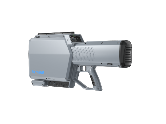
SkyfendHunter is a versatile and cost-effective handheld jammer that detects, identifies, locates, and mitigates drone threats. It effectively disrupts the control link, navigation, and video transmission of multiple UAVs simultaneously.
0 notes
Text
SkyFend Hunter: The Ultimate Handheld Drone Defense System
The SkyFend Hunter is a sleek, handheld device designed to tackle the growing threat of rogue drones in our airspace. Combining precise detection with powerful countermeasures, it offers an effective solution to modern security challenges. More than just a gadget, the Hunter serves as a vigilant protector, ensuring the safety of our skies by disabling rogue drones with precision and ease.
0 notes
Text
Optimizing Ground Sample Distance (GSD) with Drones
Drones are increasingly employed to measure Ground Sample Distance (GSD) by capturing high-resolution aerial images from different altitudes. GSD represents the distance between the centers of two adjacent pixels in an image, usually measured in centimeters per pixel. As the drone flies lower, the GSD decreases, leading to more detailed imagery. Accurate GSD is essential for applications such as mapping, surveying, and precision agriculture, where detailed and precise data is critical.
https://dynatech.ae/
0 notes
Text
The DJI Zenmuse H30 Series for Enterprise Drone Applications
The DJI Zenmuse H30 series offers advanced cameras tailored for professional aerial imaging and surveillance. With powerful zoom lenses and high-sensitivity sensors, like the 30x optical zoom on models such as the H30 and H30T, they deliver clear imagery from long distances. These cameras are adept at day and night operations, leveraging low-light performance and thermal imaging for better situational awareness in tough conditions. Renowned for setting benchmarks in aerial imaging, the DJI Zenmuse H30 Series remains a top choice among professionals worldwide.
Explore exceptional aerial imaging clarity and precision with the DJI Zenmuse H30 Series at Dynatech Innovations.

0 notes
Text
Revolutionizing Industries with Magnetometers
Magnetometers are instruments that measure magnetic fields and are transforming many industries with their precision and versatility. They come in different types, like scalar and vector magnetometers, and are used in various applications, such as geological surveys, mineral exploration, space research, and navigation. Their ability to provide precise magnetic measurements makes them invaluable in both scientific research and practical uses.
Explore the precision of magnetic field measurement with our advanced magnetometers at Dynatech Innovations.
0 notes
Text
Maximizing LiDAR Survey and Inspection Capabilities with the DJI Zenmuse L2
The DJI Zenmuse L2 is transforming survey and inspection practices with its cutting-edge LiDAR technology. Equipped with high-precision laser scanning capabilities, the Zenmuse L2 enables professionals to create detailed 3D models and topographical maps with exceptional accuracy. This advanced tool is revolutionizing industries such as construction, forestry, and infrastructure maintenance, facilitating efficient and comprehensive inspections that were once labor-intensive and time-consuming.

#inspection#surveyingdrones#lidar technology#zenmuse L2#3d model#dronesolutions#dynatechinnovations#dubai#uae
0 notes