
Don't wanna be here? Send us removal request.
Statistics
We looked inside some of the posts by dynatechinnovations and here's what we found interesting.
Average Info
Notes Per Post
1
Likes Per Post
0
Reblog Per Post
0
Reply Per Post
1
Time Between Posts
13 days
Number of Posts By Type
Text
17
Last Seen Tumblr Blogs


Fun Fact
Average visit duration of Tumblr.com is 10 mins and 25 secs.
Text
The Future of Drones in Urban Delivery Systems
Introduction
As urban populations grow and the demand for e-commerce accelerates, cities are facing mounting issues such as traffic congestion, costly last-mile deliveries, and rising carbon emissions. In response to these challenges, drone delivery technology has emerged as a transformative solution. What was once viewed as a futuristic concept is now becoming a scalable and practical method for delivering goods in a faster, more sustainable, and efficient way.

Understanding Urban Delivery Drones
Urban delivery drones are unmanned aerial vehicles (UAVs) designed to carry lightweight items—such as packages, medicines, food, and documents—across city environments. Equipped with GPS navigation, autonomous flight systems, and intelligent safety features, these drones are capable of navigating complex cityscapes and delivering directly to rooftops, balconies, or designated collection points.
Why Drones Are the Future of Urban Delivery
Speed and Efficiency: Drones avoid road traffic, dramatically reducing delivery times—especially valuable for urgent deliveries like medical supplies.
Eco-Friendly Operations: Most delivery drones are electrically powered, offering a cleaner and greener alternative to conventional vehicles.
Enhanced Last-Mile Logistics: Drones simplify and improve the most expensive and time-consuming segment of delivery—the last mile.
Access to Challenging Locations: Drones can reach destinations that are difficult for vehicles, such as remote buildings, crowded streets, or high-rise apartments.
Key Technologies Driving Drone Delivery
Artificial Intelligence & Machine Learning: Enable dynamic route optimization, predictive maintenance, and fully autonomous flight operations.
5G Connectivity: Supports seamless real-time communication between drones and control systems for coordinated, responsive fleet management.
LIDAR and Computer Vision: Allow drones to detect obstacles, recognize terrain, and safely land in tight or cluttered urban areas.
GPS & Geofencing: Ensure drones stay within designated flight zones and reach delivery points with pinpoint accuracy.
Challenges on the Road to Widespread Adoption
Despite their advantages, several barriers must be addressed for drone deliveries to become mainstream:
Regulatory Issues: Differing airspace rules, drone licensing, and data privacy laws present major challenges across regions.
Payload Constraints: Current drones are limited to carrying light packages, which narrows the range of usable applications.
Urban Navigation Risks: Buildings, power lines, and weather conditions can interfere with safe and reliable drone flights.
Public Acceptance: Concerns about noise, safety, and privacy may slow adoption without proper community engagement.
0 notes
Text
The Swan-K1 is a versatile drone with excellent stability and precision, equipped with a 4K camera for high-quality aerial surveying, mapping, and inspections. Its sturdy design and easy-to-use controls make it suitable for both beginners and experienced pilots. Whether for construction, agriculture, or environmental monitoring, the Swan-K1 delivers reliable performance to gather detailed data from the air.
#construction drones#monitoring#precision#swan k1#vtol#dronesolutions#drone accesories#dynatechinnovations
0 notes
Text

The DJI Matrice 350 RTK is the ultimate solution for construction professionals looking to streamline project management and improve accuracy in surveying and mapping, with its advanced RTK capabilities and rugged design, making it ideal for large-scale site inspections, progress tracking, and topographic mapping.
Discover more features of DJI Matrice 350 RTK at Dynatech Innovations.
0 notes
Text
The Matrice 350 RTK's ability to navigate complex environments, combined with its long battery life and payload versatility, makes it an indispensable tool for tasks such as inspecting infrastructure, monitoring site conditions, and improving workflow efficiency. As construction projects grow in complexity, drones like the Matrice 350 RTK are helping companies stay on schedule, reduce costs, and improve safety.
0 notes
Text
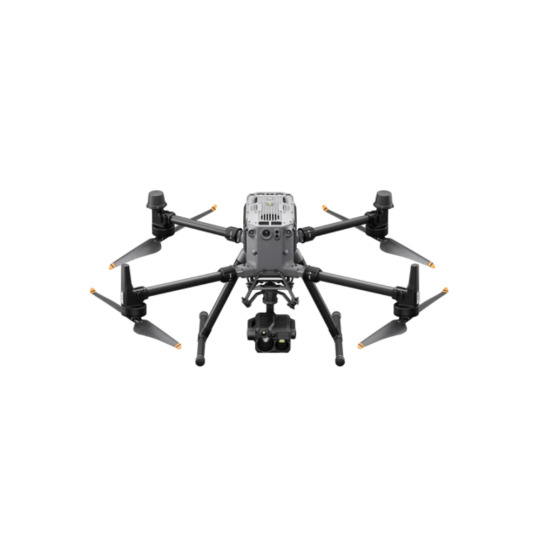
The DJI Matrice 350 RTK plays a pivotal role in construction by enhancing surveying, mapping, and monitoring processes. Equipped with high-precision RTK (Real-Time Kinematic) technology, this drone delivers centimeter-level accuracy, making it ideal for tasks such as site surveys, volumetric calculations, and progress tracking. Its robust payload capacity allows it to carry multiple sensors, including high-resolution cameras and LiDAR systems, which are essential for creating detailed, 3D maps of construction sites.
0 notes
Text
Advances in Drone Technology for Construction
Advances in drone technology are revolutionizing the construction industry by enhancing efficiency, safety, and precision. Drones are now integral to construction projects, offering aerial surveying, real-time site monitoring, and progress tracking. They capture high-resolution images and 3D models, enabling construction teams to plan, design, and manage projects with greater accuracy. Drones also improve safety by conducting inspections in hard-to-reach or hazardous areas, reducing the need for human workers to be exposed to dangerous conditions. As drone technology evolves, their integration into tasks like site mapping, structural analysis, and building inspections continues to grow, significantly streamlining construction workflows.
0 notes
Text
the Hi-Target V500 GNSS RTK System—your ultimate solution for accurate and reliable geospatial data collection. Featuring advanced RTK technology, the V500 offers centimeter-level accuracy, robust performance in challenging environments, and seamless connectivity for all your surveying needs.
0 notes
Text
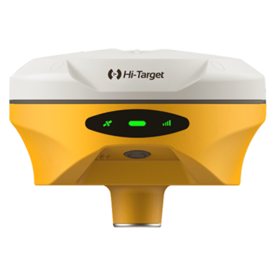
The Hi-Target V500 GNSS RTK System is the perfect choice for professionals who require exceptional accuracy, durability, and user-friendliness in their surveying and geospatial tasks. Its ergonomic design ensures easy transport and quick setup, boosting efficiency during fieldwork. With support for Real-Time Kinematic (RTK) positioning, the V500 delivers centimeter-level accuracy, making it ideal for even the most precise applications.
Discover more about Hi-Target V500 GNSS RTK System at Dynatech Innovations.
0 notes
Text
Hi-Target V500 GNSS RTK System: Precision and Portability for Surveying Excellence
The Hi-Target V500 GNSS RTK System is a versatile, high-precision solution tailored for applications such as construction, land surveying, and geospatial data collection. Combining advanced RTK technology for centimeter-level accuracy with a lightweight, durable design, it offers exceptional portability and reliability. Its intuitive interface, extended battery life, and rugged construction optimize efficiency and productivity in the field.
0 notes
Text
The DJI Mavic 3 Enterprise is a professional-grade drone ideal for industries like maritime operations, surveying, and public safety. It features high-resolution imaging, thermal sensors, and real-time data transmission for enhanced situational awareness. With extended flight time and obstacle avoidance, it navigates complex environments safely. The Mavic 3 Enterprise efficiently supports tasks like infrastructure inspection, environmental monitoring, and security surveillance, making it essential for optimizing operations across various applications.
#dji mavic 3#mavic 3 enterprise#drone technology#surveying drones#thermal sensor#maritime safety#dynatechinnovations#drones#uae
1 note
·
View note
Text

The DJI Mavic 3 Enterprise is a powerful tool for harbor surveillance, offering real-time data, high-resolution imagery, and advanced thermal capabilities. Its extended flight time and obstacle avoidance technology make it ideal for monitoring large areas, identifying potential hazards, and ensuring the safety of harbor infrastructure. With seamless data transmission, the drone enables quick decision-making, enhancing overall operational efficiency and security in maritime environments.
0 notes
Text
Transforming Harbor Management with DJI Mavic 3 Enterprise
In the ever-evolving world of maritime operations, optimizing harbor management is now more critical than ever. The DJI Mavic 3 Enterprise drone has become a transformative tool, offering real-time data, high-resolution imagery, and thermal capabilities. These features provide valuable insights into harbor infrastructure, environmental conditions, and security. With extended flight time, obstacle avoidance, and seamless data transmission, harbor personnel can make informed, efficient decisions to ensure safe and effective operations.
0 notes
Text

The Sentera 6X Thermal Sensor is a cutting-edge device designed for aerial thermal imaging and monitoring. It captures high-resolution thermal data, enabling users to detect temperature variations in various applications, such as agriculture, construction, and environmental assessments. The sensor is lightweight and easily integrated with drones, allowing for efficient and cost-effective data collection over large areas.
#thermal sensor#thermal imaging inspection#dronesolutions#technology#imaging#dynatechinnovations#dubai
0 notes
Text

The EchoLogger ECT 400S Echo Sounder is a cutting-edge device designed for precise underwater exploration. It utilizes advanced sonar technology to measure water depth and create detailed maps of the seafloor. Lightweight and user-friendly, this echo sounder is ideal for marine researchers, surveyors, and boaters seeking to understand underwater environments.
0 notes
Text
Exploring the Depths: The EchoLogger ECT 400S Echo Sounder
The EchoLogger ECT 400S emerges as a cornerstone of precision and reliability, seamlessly integrating into our endeavors to chart the uncharted and illuminate the obscured realms that dwell beneath the waves. The EchoLogger ECT 400S Echo Sounder, along with bathymetric surveys, guides us in exploring this mysterious realm. Each depth measurement and map brings us closer to unraveling the secrets of the underwater world. With each precise depth measurement and meticulous mapping, we inch closer to unraveling the secrets that have long eluded us.
You can explore more such advanced drones at Dynatech Innovations, where cutting-edge technology meets exceptional engineering.
#echologger#surveying drones#underwaterdrone#surveillance#technology#drone inspection services#dronesolutions#dynatechinnovations#uae
0 notes
Text
Anti-drone jamming systems are advanced technologies designed to disrupt the communication signals between rogue drones and their operators. By employing sophisticated jamming techniques, these systems effectively neutralize unauthorized drone activity in sensitive areas, such as government facilities, airports, and event venues. With the ability to prevent drones from receiving commands, these systems enhance security and protect privacy by mitigating potential threats. As drone usage continues to rise, anti-drone jamming systems play a crucial role in maintaining safe airspace and safeguarding individuals and assets from unwanted aerial intrusions.
Explore a wide range of such anti-drone jamming systems at Dynatech Innovations.
0 notes
Text
Discover the magic beneath the waves with underwater drones at Dynatech Innovations! Perfect for adventurers, photographers, and marine researchers alike, these innovative devices allow you to explore vibrant underwater ecosystems like never before. With high-definition cameras and advanced stabilization technology, you can capture stunning visuals and document your underwater discoveries effortlessly.
0 notes