#exoplasim
Explore tagged Tumblr posts
Visit Tumblr Blog
Explore Tumblr blogs with no restrictions, modern design and the best experience.
Last Seen Tumblr Blogs


Fun Fact
Premium Tumblr themes are available from anywhere between $9 to $49.
Text
Approximate extent of climate zones on Qefre. Dark blue is rainforest, light blue tropical savannah; shades of green are temperate climates (Cxa/b/c on the Koppen chart), red and pink are arid, orange and beige are semiarid, gray is polar tundra/high altitude wasteland. The faded teal color is sort of a weird intermediate tundra I marked out because those regions definitely hit higher temperatures more frequently than the gray tundra, but on multiyear averages for temperature they still fall under the Köppen "tundra" classification, since these warm periods are erratic and intermittent.
There are a couple of quirks here: the planet's year is so short that despite comparable axial tilt to Earth (~25 degrees), there is very little seasonality to temperatures, especially near large bodies of water (and everywhere else is parched, so tends to dissolve into the all-encompassing "arid" or "cold arid" climate zones). The lack of distinct seasonality is why there aren't any mediterranean or monsoon climates, and why there's a sort of weird intermediate tundra climate instead of real continental climates. In our world, continental climates tend to be pretty heavily forested; in those regions on Qefre, you don't get growing seasons long enough (or with enough consistency) to support large plant growth, so I don't think they fit in with the spirit of the traditional continental or subarctic Köppen criteria. Some of the highland regions are very high--Dahar Mons is over 10 kilometers tall, which is airliner cruising altitude, making its summit more Martian than anything else.
Qefre's average temperature is ~15 degrees, so comparable to Earth; the equatorial deserts regularly get as high as 50 degrees, and the polar wastes as low as -55. Several of the regions in gray probably have small ice caps, especially in the southern highlands.
17 notes
·
View notes
Text
Toward revised climates for Sogant Raha
A couple of weeks ago I finally got ExoPlaSim running, as detailed in this post from Worldbuilding Pasta; it's a finicky-as-hell piece of software, but it's also basically the only global climate model that seems remotely accessible to the conworlder who does not actually study this stuff for a living. And since it's pretty slow, especially on my antiquated machine, I looked into renting a virtual server from the same folks who do my webhosting. This is something I've never done before, and I was pleasantly surprised at how incredibly cheap it was--I'm paying about sixty Euro-cents a month at my current usage rates.
With a great deal of trial and error, I've been running climate models of Sogant Raha with different starting parameters. Mostly the failure states are pretty uninteresting--when I reduced the atmospheric pressure by 10% for instance, I had to crank up the CO2 levels a surprising amount or I just got an endless parade of snowball planets. Too much insolation and the whole planet is desert. The sweet spot for a stable climate (with Earthlike nitrogen and oxygen ratios) seems to be around 600 ppm of CO2, which is high compared to the pre-industrial baseline for the Holocene, but well within Earth's historic range.

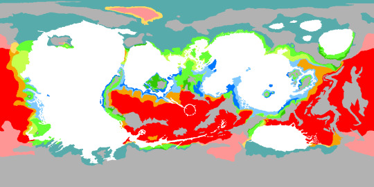
This is the interpolated global climate map for Sogant Raha based on the last simulation. (Keep in mind the prevailing wind direction is the opposite of Earth's.) Some of the features are exactly what I was hoping for: that nice belt of equatorial rainforests, for instance, and a mild climate even at very high latitudes near the south pole. The rugged terrain of the northern polar regions probably influences the formation of tundra there.
There are some issues that definitely are due to needing to do another pass on the topography data; some mountain ranges are too high, which makes western Altuum too dry, I think. Central Demora (the left of the two small continents in the north-central region of the map) is much drier than I expected, probably due to topography and the low resolution of the model. Several islands are a lot drier than they should be; this is a know issue with ExoPlaSIm, apparently. I'm most surprised by the giant desert on the north end of Rezana (the southern continent in the group of three on the left). That region has comparatively low relief and water on three sides; even if it's not very wet, it should be wetter than that, I reckon. I'll have to dig into the data and see what that's about. And the desert in the northwest of Vinsamaren also makes no sense to me; it's equatorial, and there isn't an appreciable rain shadow in that region.
Sogant Raha is very much not a bottom-up project, in that it started with a group of stories I wanted to tell, and then I started thinking about how to link those stories together in a world that had internal consistency, and only much later did I start looking into stuff like climate and geology, so I'm actually quite pleased that I can get something comparatively close to my original design without any major revisions. The biggest change from my previous biome map is just the planet's axial tilt--instead of being very low, it is now rather high, around 30 degrees. No valleys of eternal night on the poles, which is a pity, but I can still have my south polar islanders who spend half the year sailing from island to island in perpetual darkness.
#the exoplasim model is also inexact enough#that you have a fair bit of wiggle room when translating it to a detailed climate map#like if you run it on earth#you get a decent approximation that still fucks up a lot of specific details#so it's not like you have to take the simulation results as gospel#worldbuilding#sogant raha#tanadrin's fiction
31 notes
·
View notes
Text
unfortunately as far as actual GCMs go, ExoPlaSim is the extremely simple for amateurs version. and with the scripts Worldbuilding Pasta posted, it's pretty easy to generate like a basic Köppen map for a conworld. for me the hard part was 1) getting it not to crash, and 2) making sure all the dependencies were correct.
15 notes
·
View notes
Text
I used Claude to try to help me accomplish a moderately complicated task in Blender--mapping the revised model of Pr's interior I made to a heightmap on a cylindrical projection--and I feel like I'm getting a much better handle on what it can and cannot do. It felt like a more useful version of Google: a way to generate ideas for things to try, that previously I would have found by trying to search different combinations of relevant keywords, but nowhere near enough to get me all the way there, and sometimes simply wrong about some functionality in GIMP or Blender despite their extensive documentation. That's fine; it was still much better than trying to go only on my own guesswork, but LLMs as an improved search engine is as much an indictment of the state of search these days as it is a reflection of the (genuinely impressive) advances LLMs have made.

My usual mapmaking workflow doesn't fit terribly well here, just because the terrain is so different, but the above image I think gives you an idea. It's the map you might make if you were floating in the middle of Pr and could perfectly see the surface under you in every direction. I chose a cylindrical projection because Pr has negligible gravity in its interior--most of the force you feel is the centrifugal force. Red regions are "deepest," i.e., furthest from the axis of rotation, and they experience the strongest "gravity." White regions are "highest," i.e., closest to the axis of rotation; they experience negligible "gravity."
The cut-off stump shapes are the massive crystalline spars of diamond that criss-cross Pr's interior; they have been removed so the terrain below them is visible (and I didn't include them in the model). There are small bodies of water and streams at most of the lower elevations, not shown on this map, since air circulates generally throughout Pr's interior; continuous evaporation carries moisture from even the furthest-down seas up into other parts of Pr, and there's no lapse in air pressure with altitude. Gravity isn't what's keeping Pr's atmosphere contained, just rock; a big puncture in the crust would render the whole world uninhabitable in a geologically very brief time.
Also not really obvious in this map is the extreme relief of some of the terrain. The scarp between the yellow highlands in the north and the orange-and-red lowlands to their south is hundreds of kilometers, an immense wall of rock. Similar scarps surround the concavities in the southeast on most sides. And although you would still die pretty horribly if you fell that whole distance, it would take you a lot longer to get up to speed: at datum, objects only accelerate at about 25 cm per second squared. At that rate it would take you almost thirteen minutes to reach terminal velocity.
Pr's interior is very dim. It gets no sunlight, of course. Although it has a nitrogen-oxygen atmosphere like ours, the scattering of light from distant regions would make them appear redder the further away they are; they would also mostly blur away entirely after tens of kilometers, so the "sky" of Pr is naturally very dark. But a huge variety of organisms on Pr are bioluminescent, taking advantage of the plentiful energy of Ast's powerful magnetic field, and many of them fly or glide vast distances thanks to the extremely low gravity--so although there's no sun and no stars, Pr is full of soft light rising from the ground below, and floating in the air above as well.
I still have to cogitate on how some things like erosion and weather ought to work before I refine the map further. Pr definitely gets substantial heat flow from the exterior surface lit by Ast, so it has weather, I'm just not sure what kind. And obviously ExoPlaSim is not going to be a lot of use here!
17 notes
·
View notes
Text
the reason i spent all afternoon fixing my linux partition is that @youarenotthewalrus linked me to a really neat worldbuilding blog last night; they run through a bunch of different climate variations using ExoPlaSim playing with stuff like obliquity and rotational period, and it made me realize my climates for Sogant Raha are all wrong--indeed, the lack of axial tilt and seasonal variation has the exact opposite consequence of what i thought it did: very harsh temperature differences, almost no temperate zones.
i wanted to see if i could get ExoPlaSim running on my machine, but alas after spending another couple of hours fiddling with it, I don't think I can. I think Sogant Raha's climate is salvageable if i just reverse the axial tilt, and make it greater than Earth's, but I really wanted to try to play around with different parameters more to get a better idea of what its climate zones should be like. very frustrating.
#also it would be fun to throw some of the planetocopia caprices into the simulator#and see how accurate that guy's analog method of doing climate was
37 notes
·
View notes
Text
what’s ExoPlaSim?
i want to do a more detailed post at some point once i've run a simulation longer, but the ExoPlaSim model for Qefre's climate is actually really interesting. There aren't really coherent convection cells; instead the large ocean basins, flanked by high mountains, tend to produce massive seasonal cyclonic winds, and instead of an ITCZ there seems to be a sort of turbulent group of smaller cyclonic systems around the equator. There are two strong belts of surface-level wind at high latitudes that also vary seasonally (and help feed the cyclones over the ocean basis). The final climate map will not be too beholden to the simulation, since the climate being shaped by active (if malfunctioning) terraforming equipment is an integral part of the planet's history. But it's fun to observe how tweaking parameters like planet size and amount of surface water can radically alter the kinds of weather patterns you see.
8 notes
·
View notes