#georeferencing software
Explore tagged Tumblr posts
Visit Tumblr Blog
Explore Tumblr blogs with no restrictions, modern design and the best experience.
Last Seen Tumblr Blogs


Fun Fact
Mobile US users spent an average of 115.8 minutes on Tumblr app monthly.
Text
GIS Mapping – Know about GIS Mapping and How they work
GIS mapping software - Infycons, One of the leading companies with over 25 years of experience in providing targeted products and services for civil engineers has the best GIS mapping software with facilities of georeferencing along with topographical mapping.
1 note
·
View note
Text
Extremely cool website where you can download historical georeferenced USGS topographic maps and use in GIS software- and you don't need an Esri account download it! The extent of the maps don't go very far outside of the U.S. though
link -> https://livingatlas.arcgis.com/topomapexplorer

Here's a close-up of the grand canyon stitched with four different topo maps made in 1886.
I've been looking at reservoirs and comparing them to see how drastically rivers have changed, along with other natural features that have changed

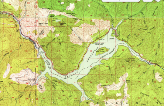
Detroit, OR 1929 (prior to the construction of the Detroit dam) vs 1956 (a few years after the dam's completion). Had no idea that there used to be a railway there, and some buildings were swallowed up when the river was flooded (i.e. the ranger station in the east portion of the lake)
anyhoo, I'm having a blast looking at old maps- going to explore the appalacians to find historic evidence of mountain top removal next, and then examples of eminent domain being used in less affluent and white areas (looking at YOU interstate-10 Bexar county)
#ramblings#I saur this and whent mentol#do I have a GIS tag yet. okay hold on#GIScore#yeah that works
20 notes
·
View notes
Text
1800 Ghosts, and counting.
So, 1800 or so ghosts live in my brain. I put them there, not on purpose, but they lodged in my mind during the course of my daily work as I found them, checked, referenced, located and georeferenced their ends. Most are pretty quiet, and really only pop up when I do something that specifically reminds me of them. But some of them are quite active, and pop into my head whenever I pass near where they died or touch on some aspect of the subject of their death.
They all died in some sort of landslide, avalanche, debris flow or rockfall, both natural or anthropogenic. Some of them I know next to nothing about. Others of them I know how they died, graphically, medically accurate details in both time, place, physics and biology. At length. Some I stood nearby as they were exhumed. I Smelt them, I stood by as they took their last journey. I looked into the faces of those who had to find, pack, lift and move them. Very occasionally I have to talk to their families. I'm not good at that.
Some of them are close relatives and ancestors of mine, but most are not. They are just people, who were doing the things that just people do.
But having them there, and knowing their story, stories, makes me a bit twitchy. There are some areas of my country, towns, cities, mountains, farmlands, forests, rivers, that I can't be in without thinking of these ghosts. Some of them are so active in my head that certain streets, certain valleys or hills, make me so uncomfortable it feels like there's someone with a rifle focussed on me, just out of sight. Because I know how dangerous the geography is, and who died there, when, and how often. Often in graphic detail.
Most of the time I'm not close in to these ghosts unless there's a major emergency response, which I am part of. Most of the work is dry, digital, old documents, GIS software, geomorphology and weather and rainfall and rock strata and pore pressure and earthquake and clay and Gravity. Gravity.
I _Enjoy_ this work. I do it for public service, because it leads into maps, risks, hazards, fatality risks, etc, making things safer for people in the future. But it leaves ghosts in my head. So I'm a bit fucked up by it.
So I now look at the people who do this day in, day out, for our soulless social media landscape. The contracted mechanical turks behind the trust and security teams, the people who classify images and videos and media behind the term 'AI' (and what an ugly term that is, because there is not yet any AI worthy of the name), as it hoses through our social media feeds straight from warzones and every other zone where something awful happens, and think how much worse this is than what I do, for better money, shorter hours, and with actual recourse to professional medical help when I need it:
Outsourcing the hard bits to where it's cheaper, to where the jurisdiction is more lenient, to where it raises less waves, is not going to help anyone in the long run. It's abdication of our own humanity made possible by corporate structure.
6 notes
·
View notes
Text
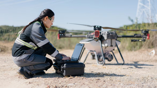
High-Precision Mapping |Our Drone & Aerial Surveying Services
In today’s fast-paced and technology-driven world, traditional surveying methods are rapidly being replaced by advanced drone and aerial surveying solutions. Whether it’s construction planning, land development, mining operations, or agricultural monitoring, drone technology is revolutionizing the way we map, measure, and manage large-scale projects.
If you're looking for top drone and aerial surveying services in India, you're in the right place. Our expert drone service providers deliver accurate, efficient, and cost-effective mapping solutions tailored to meet the diverse needs of industries across the country.
Why Choose Drone Surveying & Mapping Services?
Drone-based surveying is not just a trend—it’s a powerful tool that offers several advantages over conventional methods:
High-Accuracy Results: Capture detailed images and data with centimeter-level accuracy using GPS-enabled drones and RTK technology.
Faster Data Collection: Complete surveys that once took weeks in just hours with aerial drones.
Reduced Manpower & Cost: Cut down on labor costs and time with automated drone flights.
Safety & Accessibility: Survey remote, hazardous, or hard-to-reach areas without risking lives.
Versatile Applications: Suitable for multiple industries—construction, mining, agriculture, oil and gas, urban planning, and more.
Our Drone Surveying Services Include:
Topographic & Contour Mapping We create precise topographic maps and contour lines for land development, construction, and urban planning projects.
Orthomosaic Mapping Generate georeferenced high-resolution maps stitched from drone-captured images, ideal for planning and analysis.
Digital Elevation Models (DEM) & Digital Surface Models (DSM) Get elevation data critical for hydrological modeling, flood risk analysis, and infrastructure design.
3D Modeling & Photogrammetry Create realistic 3D models of terrain, structures, and infrastructure with detailed visual representations.
Land Surveying & Volume Estimations Accurate volume calculations for stockpiles, cut/fill operations, and earthwork planning in mining and construction.
Asset Inspection & Monitoring Perform aerial inspections for power lines, pipelines, solar farms, wind turbines, and industrial assets without shutdowns.
Industries We Serve
We provide drone surveying and mapping services for:
Construction and Real Estate
Agriculture and Forestry
Mining and Quarrying
Oil and Gas
Infrastructure Development
Environmental Monitoring
Urban Planning and GIS Projects
Pan-India Coverage with Professional Support
Our drone service network spans across Delhi, Mumbai, Bangalore, Hyderabad, Chennai, Pune, Ahmedabad, and other major cities, ensuring timely project delivery and complete regulatory compliance with DGCA (Directorate General of Civil Aviation) guidelines.
Our licensed drone pilots and GIS specialists are trained professionals equipped with state-of-the-art drones and software to deliver exceptional results. From pre-project planning to post-processing and analysis, we offer end-to-end drone solutions that are reliable, scalable, and designed for success.
Contact Us Today Ready to take your surveying and mapping projects to new heights? Contact us now for a free consultation and discover how drone technology can optimize your operations and decision-making process.
0 notes
Text
Survey Drones vs Surveillance Drones: Key Differences and Applications
In today's rapidly advancing technological landscape, drones have become essential tools across a wide range of industries. Two categories that are often mentioned — Survey Drones & Surveillance Drones — serve very different purposes, despite their surface-level similarities. Understanding the differences between them is crucial for selecting the right tool for your specific needs. In this guide, we'll explore what sets them apart and highlight their most common applications.
What are Survey Drones?
Survey drones are designed to capture highly accurate data of the Earth's surface. They are typically equipped with specialized sensors, such as high-resolution cameras, LiDAR systems, or multispectral sensors, to create detailed maps, models, and measurements of land, infrastructure, or natural environments.
Key Features of Survey Drones:
High-precision GPS and RTK/PPK positioning systems
Advanced photogrammetry software compatibility
Capable of creating 2D maps and 3D models
Equipped with LiDAR, RGB, thermal, or multispectral cameras
Focused on data accuracy, resolution, and georeferencing
Common Applications of Survey Drones:
Land surveying and topographic mapping
Construction site monitoring
Agriculture field analysis and crop health monitoring
Mining and quarry management
Infrastructure inspection (bridges, pipelines, railways)
What are Surveillance Drones?
Surveillance drones, on the other hand, are built primarily for real-time observation, monitoring, and security purposes. They are equipped with features that allow them to capture live video feeds and high-definition imagery, often with night vision and thermal imaging capabilities.
Key Features of Surveillance Drones:
Long flight times and extended range
Real-time video streaming and recording
Equipped with zoom lenses, thermal and infrared cameras
Silent operation for discreet monitoring
Often rugged and weather-resistant
Common Applications of Surveillance Drones:
Border security and patrolling
Crowd monitoring during public events
Wildlife protection and anti-poaching operations
Industrial site security
Disaster response and search-and-rescue missions
Choosing the Right Drone for Your Needs
When selecting between a survey drone and a surveillance drone, the choice largely depends on your specific application:
If you need detailed, measurable data for land development, construction, agriculture, or mining, a survey drone is the way to go.
If you require constant monitoring, real-time threat detection, or surveillance over large areas, a surveillance drone will be more suitable.
Some industries even use a combination of both types to optimize operations — for example, a construction company may use survey drones for site mapping and surveillance drones for security monitoring.
Final Thoughts
Survey drones and surveillance drones are both powerful technologies, but they serve very different purposes. By understanding their key differences and unique applications, businesses and organizations can better leverage these tools for efficiency, safety, and innovation.
As drone technology continues to evolve, the possibilities for both surveying and surveillance are expanding rapidly, offering even more specialized features tailored to every industry’s needs.
0 notes
Text
2D Drone Mapping: Transforming Data Collection from the Sky

2D drone mapping is a powerful tool that has reshaped the way industries collect, analyze, and interpret spatial data. This technique involves the use of drones, or unmanned aerial vehicles (UAVs), to capture high-resolution aerial imagery, which is then processed into detailed two-dimensional maps. These maps provide accurate representations of terrain, infrastructure, and other surface features, offering significant benefits across sectors like agriculture, construction, mining, real estate, and environmental monitoring.
At its core, 2D drone mapping involves flying a drone equipped with a high-quality camera over a predefined area. As the drone follows a flight path—often automated through GPS and mapping software—it takes overlapping photos of the ground from above. These images are stitched together using photogrammetry, a process that turns the visual data into a single, georeferenced map. The resulting 2D map can display various details depending on the purpose, including vegetation health, construction progress, or topographic contours.
One of the biggest advantages of 2D drone mapping is the speed and efficiency it offers compared to traditional land surveying methods. What once took days or weeks with ground crews and expensive equipment can now be done in a matter of hours with a drone. This rapid data collection allows for frequent updates and better project tracking, especially for fast-moving jobs like construction or crop monitoring.
Accuracy is another key strength of drone mapping. With the use of ground control points (GCPs) and real-time kinematic (RTK) positioning, drone maps can achieve centimeter-level precision. This makes them suitable for tasks like measuring distances, planning layouts, or monitoring changes over time. For example, farmers can use 2D maps to assess crop health and plan irrigation, while engineers can use them to verify construction progress against site plans.
2D mapping also improves safety by reducing the need for workers to physically access hazardous or difficult-to-reach areas. Whether it’s a steep hillside, an active construction site, or a post-disaster zone, drones can fly over and collect data without putting people at risk. This not only protects workers but also lowers insurance and liability costs for companies.
The applications of 2D drone mapping are vast. In agriculture, maps can reveal patterns of disease, pest infestation, or water stress in crops, enabling more targeted and efficient treatment. In urban planning and real estate, detailed maps help developers visualize land use and make informed decisions about zoning and design. Environmental scientists use drone maps to monitor deforestation, erosion, and habitat changes with minimal ecological disturbance.
In summary, 2D drone mapping is a game-changing technology that combines speed, accuracy, safety, and versatility. As drones become more affordable and mapping software more advanced, this method of data collection is becoming increasingly accessible to organizations of all sizes. Whether it's for monitoring progress, improving planning, or enhancing decision-making, 2D mapping with drones continues to prove its value across a wide range of real-world applications.
0 notes
Text
Overcoming Mobile Mapping Challenges in Transportation: Expert Strategies & Solutions
Introduction
Mobile mapping plays a crucial role in transportation projects, enabling accurate data collection and analysis. However, challenges such as data accuracy, processing inefficiencies, and integration complexities can hinder project success. In this blog, we’ll explore expert strategies and solutions to overcome these challenges, with a focus on leveraging photogrammetry software to enhance mobile mapping workflows.
Leverage Advanced Photogrammetry Software for Accurate Data Capture
One of the most significant hurdles in mobile mapping is ensuring accurate, high-quality data collection. Advanced photogrammetry software provides a powerful solution by converting aerial imagery into precise 3D models and point clouds.
Photogrammetry software enables the processing of drone imagery to generate detailed geospatial data.
Features like automatic image matching, bundle adjustment, and dense point cloud generation enhance mapping accuracy.
Selecting the right software improves both efficiency and data precision, reducing errors in transportation project planning.
Beyond just software, successful mobile mapping also requires:
High-quality drones and cameras for superior image capture.
Proper training of field crews on data collection best practices.
Standardized data validation processes to ensure consistency and reliability.
By combining photogrammetry software with structured workflows, transportation projects can significantly enhance mapping accuracy and efficiency.
Implement Automated Georeferencing for Efficient Data Processing
After data collection, the next challenge is processing vast amounts of mobile mapping data. Automated georeferencing streamlines this phase by precisely aligning and positioning datasets within their geographic context.
Eliminates manual tie point selection, reducing processing time.
Enhances the efficiency of photogrammetry software by ensuring seamless spatial alignment.
Reduces human error, improving overall mapping accuracy.
By integrating automated georeferencing into photogrammetry software workflows, teams can accelerate data processing and focus on actionable insights for better decision-making in transportation projects.
Utilize 4D Capabilities for Comprehensive Project Monitoring
Transportation projects are dynamic, evolving over time. Traditional 2D and 3D mapping may not capture the full picture, but 4D capabilities—incorporating the time dimension—offer deeper insights.
Photogrammetry software with 4D capabilities enables visualization of project progress over time.
It helps detect trends, patterns, and potential bottlenecks before they become critical issues.
Enhances decision-making by providing real-time insights into project developments.
Implementing 4D mapping ensures continuous project monitoring, allowing transportation planners to optimize resources and minimize delays.
Integrate with Construction Management Software for Seamless Workflows
To maximize the benefits of mobile mapping, transportation projects must integrate their geospatial data with existing construction management systems. This integration:
Centralizes project data for easy access and analysis.
Enables real-time updates across teams and systems.
Enhances collaboration by ensuring all stakeholders work with the latest data.
Reduces errors and inefficiencies, streamlining project execution.
By embedding photogrammetry software data into construction management platforms, organizations create a seamless, end-to-end workflow that improves efficiency and project outcomes.
Collaborate with Expert Partners for Optimized Mobile Mapping
Mobile mapping success requires more than just technology—it demands expertise. Collaborating with industry leaders helps organizations leverage best practices and innovative solutions.
Photogrammetry software providers offer specialized tools and training for improved data processing.
Partnering with experts in aerial imaging and geospatial analytics ensures high-quality results.
Proven industry partnerships accelerate implementation and enhance project scalability.
Selecting experienced partners with deep knowledge of this software and mobile mapping technologies guarantees optimized workflows and successful transportation project execution.
Conclusion
Overcoming mobile mapping challenges in transportation requires a combination of advanced photogrammetry software, automated georeferencing, 4D monitoring, system integration, and expert collaboration. By implementing these strategies, organizations can improve data accuracy, streamline workflows, and enhance decision-making for transportation projects.
Ready to transform your mobile mapping processes? Discover how Magnasoft's advanced geospatial solutions can help optimize transportation projects. Contact us today to learn more.
0 notes
Text
QGIS Course: Explore GIS Mapping & Spatial Analysis with Ease
Introduction:
In today’s digital era, Geographic Information Systems (GIS) have become an essential tool across industries, from urban planning to environmental management. A QGIS course is the perfect way to gain expertise in this powerful open-source GIS software, which is gaining popularity due to its affordability and extensive capabilities. If you're looking to build a career in GIS, enrolling in a QGIS course can be your gateway to mastering spatial data analysis, cartography, and remote sensing. This article explores why learning QGIS is a game-changer and presents real-life case studies to showcase its impact.
Why Choose a QGIS Course?
1. Open-Source & Cost-Effective: Unlike proprietary GIS software, QGIS is free, making it an excellent choice for students, professionals, and organizations with budget constraints.
2. User-Friendly Interface: QGIS offers an intuitive interface that simplifies data visualization, analysis, and geoprocessing, making it easier for beginners to learn.
3. Extensive Plugin Support: With a vast library of plugins, QGIS can be customized for specific applications, including 3D mapping, machine learning, and hydrological modeling.
4. Cross-Platform Compatibility: QGIS runs on Windows, macOS, and Linux, ensuring flexibility for users across different operating systems.
5. Growing Demand for GIS Professionals: Industries such as agriculture, real estate, transportation, and disaster management actively seek professionals skilled in QGIS, creating ample job opportunities.
Case Studies: Real-World Applications of QGIS
Case Study 1: Urban Planning in New Delhi, India
Challenge: The rapid urbanization in New Delhi led to unplanned infrastructure development, causing congestion and environmental concerns.
Solution: A team of urban planners used QGIS to analyze spatial data, identify high-traffic areas, and propose optimized road networks. Heat maps and demographic layers helped in planning new residential zones and green spaces.
Impact: The insights provided by QGIS led to better road connectivity, reduced congestion, and improved public transportation planning.
Case Study 2: Precision Agriculture in Maharashtra, India
Challenge: Farmers in Maharashtra faced issues with unpredictable rainfall and soil degradation, impacting crop yields.
Solution: Agricultural scientists implemented QGIS to analyze satellite imagery, soil quality maps, and climate data. This enabled precision farming techniques, such as targeted irrigation and soil-specific fertilization.
Impact: Farmers reported a 25% increase in crop yields while reducing water and fertilizer usage, contributing to sustainable farming.
Case Study 3: Disaster Management in Uttarakhand, India
Challenge: Frequent landslides in Uttarakhand disrupted transportation and endangered local communities.
Solution: Disaster response teams used QGIS to create risk maps based on terrain analysis, rainfall patterns, and historical landslide data. Early warning systems were integrated with the GIS model.
Impact: The predictive analysis helped authorities issue timely evacuation alerts, reducing casualties and property damage during monsoons.
What You Will Learn in a QGIS Course:
A comprehensive QGIS course typically covers:
Introduction to GIS & QGIS Interface
Data Import, Processing, and Visualization
Spatial Analysis and Georeferencing
Remote Sensing & Image Processing
Cartography & Thematic Mapping
Hands-on Project Work & Case Studies
Who Should Enroll?
A QGIS course is ideal for:
Students & Researchers in Geography, Environmental Science, and Urban Planning
GIS Professionals looking to upskill
Government & NGO Workers in Disaster Management and Land Use Planning
Data Analysts interested in spatial data interpretation
Conclusion:
QGIS is a powerful tool that is transforming the way industries utilize spatial data. By enrolling in a QGIS course, you gain in-demand GIS skills, opening doors to diverse career opportunities. Whether you're a beginner or a professional, learning QGIS can enhance your expertise and contribute to impactful, data-driven decision-making.
BIMMANTRA Academy equips professionals with industry-relevant BIM skills through expert training and hands-on learning. It's your gateway to a successful career in digital construction. Join today!
Start your journey with QGIS today and become a GIS expert shaping the future!
0 notes
Text
The Future of Land Surveying: How Technology is Revolutionizing the Industry
Land surveying has undergone much revolution in technology concerning construction, infrastructural projects, and property developments. Gone are the days of physical measurement in traditional methodologies by hand; currently, innovation offers precision with time and money effectiveness. In fact, the core issue covered is how modern-day technological impacts might influence land surveying prospects into the future as well as changes to be noted within this sphere.

1. Land Surveying Revolution
Land surveying dates back to ancient times, where the Egyptians and Romans used basic tools to measure land. Through time, the industry has developed with the invention of theodolites, total stations, and GPS technology. However, the digital revolution and the advent of AI, automation, and remote sensing have dramatically changed how land surveys are conducted today.
2. Cutting-Edge Technologies Reshaping the Industry
A. Drones and Aerial Surveying
Drones, or UAVs, are one of the most important technological breakthroughs in land surveying. Drones can be equipped with high-resolution cameras, LiDAR sensors, and GPS technologies to capture pictures of vast terrains that take a much lesser time span as compared to ground surveys.
Benefits of using drones for land surveying:
Speed data collection; efficient
Accuracy improved with high resolution
Economic as compared to traditional ground survey.
These are to penetrate hazardous or inaccessible places.
B. LiDAR Technology
The other land survey game-changer is Light Detection and Ranging, abbreviated as LiDAR technology. The distance measurement through the LiDAR sensor can be obtained by the emission of laser pulse. It is precise to acquire the 3-D models of topography, man-made structures, and vegetation.
High-precision Topographic Mapping; Forest and vegetation analysis; infrastructure and urban planning; Flood Risk Assessment and disaster management.
LiDAR, on its own, helps in mapping large areas with efficiency and generating real-time data for better decision-making.
C. Global Navigation Satellite Systems (GNSS)
The GNSS, GPS, GLONASS, and Galileo, have been established as indispensable tools in land surveying. The systems provide geospatial information with centimeter-level precision that eliminates human errors and manual calculations.
Benefits of GNSS technology:
- Real-time positioning and georeferencing
- Improved survey accuracy
- Reduced reliance on the traditional benchmark
- GIS and CAD compatible
D. Geographic Information Systems (GIS) and Big Data
The introduction of GIS technology has changed the way survey data is processed and presented. The GIS allows for the storage, handling, and processing of spatial data, thus becoming a tool in urban planning, environmental monitoring, and land development.
Benefits of the application of GIS in land surveying
Sophisticated mapping and visualization
Combining different sources for enhanced analysis
Better decision making in construction and real estate
Land use changes and environmental change in real-time
E. Artificial Intelligence (AI) and Machine Learning
Artificial intelligence and machine learning algorithms contribute significantly to automation in the processes of data analysis, pattern recognition, and predictive modeling in land surveying.
Applications of AI in surveying:
- Automatic extraction of features from aerial images
- Predictive models for land development
- Enhanced precision in boundary detection
- Minimization of human errors in survey calculations
With the advancement of AI technology, its application in land surveying is expected to increase, making processes more efficient and data-driven.

3. The Impact of Technology on Land Surveying
The integration of these technologies has transformed land surveying in multiple ways:
1. Improved Accuracy:
Thanks to the LiDAR, GNSS, and AI-driven software tools, much lesser errors and discrepancies have resulted in accurate measurements of surveyors.
2. Time Efficiency:
Use of drones and automated processing reduces the time spent to complete the survey, therefore quicker execution of the project
3. Cost Efficiency:
Automated tools and AI-driven analysis also ensure that money spent on labor, equipment, and time is minimized by the company.
4. Accessibility:
The invention of drones and satellite technology makes it possible to reach inaccessible, dangerous, or otherwise unreachable areas.
5. Data Integration and Visualization:
GIS and big data analytics make visualization of land data possible, which can then be used for making decisions in urban planning and infrastructure projects.
4. Challenges and Future Outlook
Adoption of new technologies in land surveying comes with its challenges, however positive the advantages may be:
- Significant Capital Expenditure: A huge one for building drones, LiDAR equipment, and AI-driven software.
- Technical Expertise:The surveyor must have professional training to handle such complex equipment and data themselves
- Mandatory Regulations and Privacy Issues:Drone and remote sensing technologies require strong regulation and privacy concerns.
- Cyber Security in Managing Huge Volumes of Geospatial Data: It requires a strong approach to cybersecurity.
Land surveying of the future is likely to move upwards on automation, cloud storage of data, and AI power. Trends emerging include blockchain in safe land record management and augmented reality in interactive land surveying.
5. Conclusion
Technology is revolutionizing land surveying at a pace like no other time, making it more productive, accurate, and cost-effective. From drones and LiDAR to AI and GIS, all these are leading the industry to a more data-driven and automated future. With the challenges, innovation and adaptation will continue to ensure that land surveying is a critical part of modern infrastructure and development. It is important that professionals in this industry evolve with such change as technological improvement will continue moving forward in order to remain competitive and offer the best possible surveying solutions for an ever-changing world.
#Land surveyor Thrissur#Land Survey#Property Survey#Real Estate Survey#Revenue Survey#Building Survey#Quantity Survey
0 notes
Text

Geographic Information System (GIS) is a system used to collect, manage, analyze, and display geographic/spatial/map-based data. QGIS (Quantum GIS) is a popular open-source software in the GIS world. QGIS provides various features for visualizing, analyzing, and managing spatial data. As a free alternative to paid GIS software, QGIS supports various data formats, such as shapefiles, rasters, and spatial databases. With GIS and QGIS, users can create thematic maps, perform spatial analysis, and manage geographic data efficiently. The advantages of QGIS as open-source software make it the main choice for academics, researchers, and practitioners in various fields.
#attribute query#select by attribute#feature info#opensource#gis operator#geodatabase#spatial query#select by location#location allocation#location intelligence#location based services#gis#geoserver#arcgis#esri#openlayers#wms#wfs#web mapping#leaflet#shapefile#qgis#geonode#freelancer#gis analyst#gis jobs#webgis#development#gis professional#project management
0 notes
Text

QGIS (Quantum GIS) is a popular open-source software in the GIS world. QGIS provides various features for visualizing, analyzing, and managing spatial data. As a free alternative to paid GIS software, QGIS supports various data formats, such as shapefiles, rasters, and spatial databases.
#attribute query#select by attribute#feature info#opensource#gis operator#geodatabase#spatial query#select by location#location allocation#location intelligence#location based services#gis#geoserver#arcgis#esri#openlayers#wms#wfs#web mapping#leaflet#shapefile#qgis#geonode#freelancer#gis analyst#gis jobs#webgis#development#gis professional#project management
0 notes
Text

My name is Danish murad, and I'm a passionate GIS expert with over 7 years of experience.
I will make professional and creative maps and any GIS related designs. I am creative works in Maps, remote sensing, and GIS systems including Digitizing, Georeferencing, Map designing, GIS Analysis, Drainage system creating, 3D Analysis, Drone Image processing, etc. I am passionate about the field I made maps and building Geodatabase using any GIS Software ( ESRI ArcGIS package, Google Earth, QGIS,
0 notes
Text

Ways To Improve Accuracy Of Drone Mapping Programs In Challenging Environments
Drone mapping is seriously cool, but things get tricky when flying in challenging environments like dense forests, mountainous terrains, or areas with sketchy weather. If you’ve ever tried to capture high-precision maps and felt like your drone was fighting against nature, don't worry—you’re not alone! In this blog-style breakdown, we will cover some of the best ways to improve drone mapping accuracy, especially in tough situations.
1. Use Ground Control Points (GCPs) Like A Pro
If you want next-level accuracy, Ground Control Points (GCPs) are your best friends. These are marked spots on the ground with known coordinates, which you can later use to align your map data. Without GCPs, your drone might think it's doing a great job, but your map could be slightly off. In challenging environments, this slight miscalculation can become a big deal. So, invest some time in setting up GCPs around your area before starting the flight. It’s a small effort that pays off big when you’re trying to get precise results.
2. Pick The Right Sensors
Not all drone cameras are built the same. In tough environments, traditional RGB cameras can struggle to capture every detail. This is where specialized sensors come into play. LiDAR (Light Detection and Ranging) is a solid choice for dense forests or areas with lots of obstacles. It sends out pulses of light and measures how long they take to return. This helps the drone “see” through obstacles and create accurate 3D maps. Multispectral cameras are another good option, especially in agricultural or forestry settings. These cameras pick up information that human eyes can’t, giving you more detailed data to work with.
3. Fly At The Right Altitude And Speed
Flying too high or too fast can throw off your map accuracy, especially in tough environments. The rule of thumb is simple: the lower and slower, the better. When you’re flying lower, the drone’s camera can pick up more details, and flying slower allows it to capture more precise data points. In environments where obstacles like trees or cliffs can interfere with data collection, this approach becomes even more critical.
4. Pre-Plan Your Flight Paths
Before launching your drone, make sure you’ve pre-planned your flight path. Use software that allows you to set waypoints and control your drone's flight with pinpoint precision. In challenging environments, this planning helps avoid obstacles, ensuring your drone stays on course and covers the entire area. Plus, you’ll avoid any last-minute panic when your drone suddenly approaches a giant tree!
5. Improve Your Post-Processing Game
Once your drone lands, the mission isn’t over yet. The magic happens in post-processing! The software you use to stitch the images and generate the map is just as important as the flight itself. Make sure you're using software with advanced algorithms that can correct for any distortions caused by rough terrains. Also, try to use tools that support georeferencing so that you can align your map to real-world coordinates more accurately. This will dramatically improve the quality of your final map.
Why The AUTEL ALPHA Is The Ultimate Drone For Challenging Mapping Jobs!
Now, let us save you some trouble searching for the best drone to handle all mapping needs. Meet the AUTEL ALPHA from MAVDRONES—your new mapping sidekick! This beast of a drone is specifically designed to tackle tough environments with ease. Equipped with a high-quality LiDAR sensor and a multispectral camera, it doesn’t just capture stunning visuals; it goes deep to deliver the kind of data you need for accurate mapping. It also features advanced waypoint planning and obstacle avoidance, making it ideal for flying in tricky environments like dense forests or rugged terrains.
Plus, with its long flight time and ability to maintain stability even in windy conditions, you won’t have to worry about your drone cutting the mission short. If you’re serious about drone mapping and want to level up your game in challenging environments, the AUTEL ALPHA is where it’s at. It’s like having a mapping expert in the sky! So there you have it! From using GCPs to flying smart, these tips will help you get the most accurate drone maps, no matter the environment. Trust the AUTEL ALPHA to make your mapping missions smooth and successful.
0 notes
Text
What is GIS Mapping?
In today’s digital age, Geographic Information Systems (GIS) has emerged as a vital tool for analyzing spatial data. GIS mapping, short for Geographic Information System mapping, enables us to visualize, analyze, and interpret geographic and spatial data, facilitating informed decisions. This technology captures, stores, manipulates, and presents spatial information, integrating maps, satellite imagery, aerial photos, and data from sources like GPS devices and surveys into a unified platform, yielding valuable insights into geographic relationships.
Key Components of GIS Mapping
The underlying technology behind GIS has four key components:
User — Professionals with expertise in fields such as GIS analysis, cartography, and geography play a pivotal role in the conception, upkeep, and interpretation of GIS maps.
Spatial Data — GIS mapping draws upon an extensive array of geographic information, encompassing geographical elements like rivers, mountains, and roadways, alongside attribute data that includes population demographics, land utilization, and infrastructure particulars.
Hardware — GIS systems necessitate essential hardware components like computers, GPS devices, and remote sensing technologies for effective data acquisition and processing.
Software — Dedicated GIS software applications such as ArcGIS, QGIS, and Google Earth Pro are employed to craft, assess, and present maps and spatial data.
GIS Maps
After data undergoes processing and analysis, GIS software generates visual representations in the form of maps. These maps incorporate various data layers, including points, lines, polygons, and raster images. Users of GIS can craft map compositions by amalgamating multiple map layers, encompassing base maps, thematic layers, and labels. This approach empowers users to tailor maps to specific purposes. Additionally, GIS maps often incorporate interactive functionalities. By clicking on map elements, users can access supplementary information, run spatial queries, or conduct real-time analyses. GIS maps and their associated data can be disseminated in various formats, including printed maps, web-based maps, or mobile applications. Online platforms and cloud-based GIS services simplify the process of sharing maps with a wider audience.
Benefits of GIS Mapping
Data Visualization: GIS mapping provides a lucid visual representation of intricate spatial data, enhancing comprehension and communication.
Informed Decision-Making: It empowers decision-makers to make data-driven choices, resulting in more efficient resource allocation and issue resolution.
Enhanced Collaboration: Teams from different departments and locations can seamlessly collaborate through shared GIS platforms.
GIS mapping stands as a versatile and indispensable instrument, fundamentally transforming our approach to comprehending and evaluating our planet. The applicability of GIS mapping transcends virtually every sector, solidifying its status as a crucial technology in our contemporary society.
AABSyS has a highly experienced team of GIS professionals and has rich experience in providing high-quality yet cost-effective solutions to its customers.
The typical GIS Mapping services offered by AABSyS include:
Land use/ Land cover (LULC) Classification
Georeferencing, mosaicking, and seamless raster data products
Terrain mapping
Digital elevation modeling
Change detection analysis
Mapping & advanced spatial analysis
3D building and vegetation models
For more information, please visit — Data Services
1 note
·
View note
Text
Sky-High Solutions: Enhancing Surveys with Drone Aerial Mapping
Elevate your surveying capabilities with the transformative potential of drone land surveying, revolutionizing the way you gather, analyze, and utilize geospatial data. Our comprehensive drone mapping services combine cutting-edge technology with expert piloting to deliver high-quality aerial imagery and topographic information for a myriad of applications. Whether you're conducting land surveys, infrastructure inspections, or environmental assessments, our drones offer unparalleled versatility and efficiency to meet your project objectives with precision and speed.
Efficiency and Precision:
Streamlined Data Collection: Harness the agility and speed of drones to efficiently capture aerial imagery and topographic data, accelerating the surveying process and reducing project timelines.
Geospatial Accuracy: Obtain precise and georeferenced data for accurate measurements and analysis, empowering informed decision-making and project planning.
Versatility and Adaptability:
Accessible Reach: Overcome geographical obstacles and access hard-to-reach areas with ease, ensuring comprehensive coverage of survey sites without logistical constraints.
Multi-Application Capability: From land development to environmental monitoring, drones offer versatile solutions to address a wide range of surveying needs across industries and sectors.
Cost-Effectiveness and Accessibility:
Optimized Resource Utilization: Maximize operational efficiency and minimize costs with drone-based surveys, optimizing resource allocation and project budgets.
Improved Accessibility: Navigate challenging terrain and remote locations effortlessly, enhancing survey accessibility and coverage compared to traditional methods.
Data Processing and Analysis:
Advanced Data Processing: Utilize sophisticated software tools to process drone-captured data into detailed maps, orthomosaics, and 3D models, enabling comprehensive analysis and visualization.
Customized Reporting: Receive tailored reports and visualizations to suit your project requirements, facilitating clear communication and actionable insights for stakeholders.
Safety and Compliance:
Risk Mitigation: Prioritize safety by conducting surveys remotely, reducing on-site risks and hazards associated with traditional surveying methods.
Regulatory Compliance: Adhere to aviation regulations and industry standards, ensuring ethical and legal operation of drone aerial mapping activities.
Embrace the future of surveying with drone aerial mapping solutions tailored to your project needs. Contact us today to discover how our expertise and technology can elevate your surveying endeavors and deliver superior results.

For more details: Visit Us - https://aerologix.com/navigating-the-future-an-in-depth-guide-to-drone-land-surveying-down-under/
0 notes
Text
2D Drone Mapping
Introduction

2D drone mapping is a modern surveying technique that uses drones equipped with high-resolution cameras to capture aerial images and generate detailed, georeferenced maps. This technology is widely used in agriculture, construction, urban planning, environmental monitoring, and disaster management. By providing fast, accurate, and cost-effective mapping solutions, 2D drone mapping has revolutionized traditional surveying methods.
How 2D Drone Mapping Works
1. Flight Planning
Before data collection, a flight plan is created using drone mapping software. Parameters such as altitude, camera angle, speed, and image overlap (typically 70-80%) are set to ensure complete area coverage.
2. Aerial Image Capture
The drone flies autonomously or manually over the designated area, capturing high-resolution images at regular intervals. The images overlap significantly to allow seamless stitching during processing.
3. Image Processing
After data collection, specialized software stitches the images together using photogrammetry techniques. The result is a detailed 2D orthomosaic map, which is georeferenced and corrected for distortions.
4. Analysis & Application
The final map is analyzed using Geographic Information System (GIS) software to extract valuable insights such as measurements, land classifications, and environmental changes.
Applications of 2D Drone Mapping
1. Agriculture
Farmers use 2D drone maps to monitor crop health, detect pests, and optimize irrigation. Vegetation indices like the Normalized Difference Vegetation Index (NDVI) help assess plant health and improve yield management.
2. Construction & Urban Planning
2D mapping assists engineers and urban planners in site planning, land surveying, and infrastructure development. It provides accurate topographic maps, helping in project visualization and progress tracking.
3. Environmental Monitoring
Drones help in tracking deforestation, coastal erosion, and climate change effects. Conservationists use 2D maps to analyze ecosystem changes and implement protective measures.
4. Disaster Management
Drones provide real-time maps for assessing damage caused by floods, earthquakes, or wildfires. Emergency responders use these maps to plan rescue operations and allocate resources efficiently.
5. Infrastructure & Utility Inspection
Power lines, pipelines, and roadways are mapped for maintenance and repair planning. Engineers use the maps to detect wear and tear, ensuring timely interventions.
Benefits of 2D Drone Mapping
Cost-Effective: Reduces the need for expensive manned surveys.
Time-Saving: Faster than traditional mapping methods.
High Accuracy: Provides precise, georeferenced data.
Enhanced Safety: Eliminates the need for manual surveying in hazardous areas.
Scalability: Suitable for small and large-scale projects.
Conclusion
2D drone mapping is transforming industries by offering a fast, accurate, and affordable solution for surveying and mapping. With advancements in drone technology and data processing software, its applications will continue to expand, making it an essential tool for data-driven decision-making across multiple sectors.
0 notes