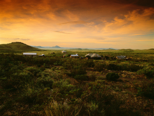
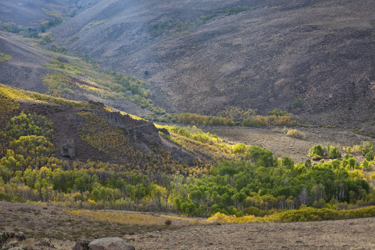
#in the foothills of the san rafael mountains
Text
.
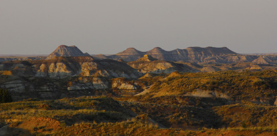
#for the record#today would have been the first time#I actually did tenkara fishing#in a tiny creek I have decided to visit#at a cool birdwatching spot#in a remote canyon#in the foothills of the san rafael mountains#except#it was rainy#and I was insufficiently adventurous#there may or may not be trout there#and if there are they could well top out at four inches or so#but I won’t know#until later#closer…
8 notes
·
View notes
Text
Trinidad’s Healthcare and Wellness Facilities in Colorado, United States.
Trinidad, nestled in the picturesque southern Colorado, is not just known for its stunning landscapes but also for its robust healthcare and wellness facilities. From cutting-edge medical centers to holistic retreats, Trinidad offers a diverse array of options to cater to the healthcare needs and wellness pursuits of its residents and visitors alike.Click Here
At the heart of Trinidad’s healthcare landscape is the Mt. San Rafael Hospital, a leading medical institution serving the community for over a century. With state-of-the-art facilities and a team of skilled healthcare professionals, Mt. San Rafael Hospital provides comprehensive medical services ranging from emergency care to specialized treatments in various fields including cardiology, orthopedics, and oncology.
Complementing traditional medical care are Trinidad’s alternative and holistic wellness centers, which have gained popularity for their holistic approach to health and well-being. The Wellness Center at Mt. San Rafael Hospital offers a range of services such as acupuncture, massage therapy, and nutritional counseling, emphasizing the importance of treating the whole person – body, mind, and spirit.
Trinidad’s commitment to holistic health extends beyond physical well-being to include mental and emotional wellness. The city boasts several mental health centers and counseling services, providing support and resources for individuals facing various mental health challenges. From therapy sessions to support groups, these facilities play a crucial role in promoting mental wellness and resilience within the community.
For those seeking a deeper connection with nature and a break from the hustle and bustle of everyday life, Trinidad offers serene retreats and wellness resorts amidst its breathtaking natural surroundings. Whether it’s a yoga retreat in the foothills of the Sangre de Cristo Mountains or a meditation retreat overlooking the tranquil waters of Trinidad Lake, visitors can rejuvenate their mind, body, and soul in these idyllic settings.
In addition to traditional healthcare and wellness services, Trinidad embraces a variety of alternative healing modalities rooted in ancient practices and indigenous wisdom. From energy healing and herbal medicine to shamanic rituals and sound therapy, individuals have access to a rich tapestry of healing traditions that honor the interconnectedness of all beings and the natural world.
Trinidad’s commitment to healthcare and wellness extends beyond its borders through community outreach programs and initiatives aimed at promoting health education and preventive care. From wellness fairs to fitness classes, the city actively engages its residents in activities that empower them to take control of their health and well-being.
As Trinidad continues to evolve as a hub for healthcare and wellness in Colorado, it remains dedicated to fostering a culture of health and vitality that enriches the lives of its residents and visitors. Whether you're seeking medical treatment, holistic healing, or simply a retreat to recharge and rejuvenate, Trinidad offers a wealth of options to support your journey towards optimal health and well-being.
With its blend of modern medicine, holistic therapies, and a deep reverence for nature, Trinidad stands as a beacon of health and wellness in the heart of southern Colorado, inviting all who seek healing and renewal to experience its transformative offerings.
0 notes
Text
Title Loans in California
No Credit Check Title Loan in California Fast CA & Nationwide USA. Get Qualified for Title Loans Near Me Today. Fair Cash Offers. Any Location: Online Title Loans California, Get a Loan With Car Title in California Nationwide USA! 1 (833) 461-0143
California Title Loans
Finding the best direct quick approval instant loan lender for bad credit is vital so that you get the loan at the best possible rates and no hidden fees. There are many online payday loan providers offering cash loans instantly at lower than the prevailing average rates in order to get more clients.
Title Loan California is here to help you find the right instant cash lender, so that you would get the immediate cash online easily and also quickly. Hence, it is important to take your time when choosing the right online payday loan with same or next day approval in California!
California
Los Angeles | San Diego | San Jose | San Francisco | Fresno | Sacramento | Long Beach | Oakland | Bakersfield | Anaheim | Stockton | Riverside | Santa Ana | Irvine | Chula Vista | Fremont | Santa Clarita | San Bernardino | Modesto | Moreno Valley | Fontana | Oxnard | Huntington Beach | Glendale | Santa Rosa | Elk Grove | Ontario | Rancho Cucamonga | Oceanside | Lancaster | Garden Grove | Palmdale | Salinas | Hayward | Corona | Sunnyvale | Pomona | Escondido | Roseville | Torrance | Fullerton | Visalia | Orange | Pasadena | Victorville | Santa Clara | Thousand Oaks | Simi Valley | Vallejo | Concord | Berkeley | Clovis | Fairfield | East Los Angeles | Richmond | Antioch | Carlsbad | Downey | Costa Mesa | Murrieta | San Buenaventura (Ventura) | Temecula | Santa Maria | West Covina | El Monte | Inglewood | Burbank | El Cajon | San Mateo | Jurupa Valley | Daly City | Rialto | Norwalk | Menifee | Vacaville | Chico | Hesperia | Vista | Compton | Carson | San Marcos | Arden-Arcade | Mission Viejo | Redding | Santa Monica | Tracy | South Gate | Chino | San Leandro | Westminster | HemetIndio | Santa Barbara | Hawthorne | Livermore | Citrus Heights | Whittier | Merced | Lake Forest | Newport Beach | San Ramon | Redwood City | Buena Park | Manteca | Alhambra | Lakewood | Mountain View | Folsom | Tustin | Milpitas | Pleasanton | Carmichael | Rancho Cordova | Napa | Bellflower | Upland | Perris | Chino Hills | Alameda | Pittsburg | Apple Valley | Redlands | Turlock | Dublin | Baldwin Park | Rocklin | Redondo Beach | Camarillo | Lake Elsinore | Union City | Walnut Creek | Yuba City | Eastvale | Tulare | Palo Alto | Yorba Linda | Lynwood | Davis | Castro Valley | Lodi | Madera | South San Francisco | Laguna Niguel | San Clemente | Brentwood | La Habra | Santa Cruz | Montebello | Porterville | Pico Rivera | Encinitas | Florence-Graham | San Rafael | La Mesa | Monterey Park | Woodland | Gardena | Cupertino | Santee | Petaluma | Gilroy | Hanford | Fountain Valley | Highland | Arcadia | South Whittier | National City | Diamond Bar | Huntington Park | Yucaipa | Hacienda Heights | West Sacramento | Colton | San Jacinto | Paramount | Novato | Beaumont | Watsonville | Glendora | Florin | Aliso Viejo | Placentia | Cathedral City | Delano | Covina | Rosemead | Palm Desert | El Dorado Hills | Cypress | Azusa | Lincoln | Cerritos | North Highlands | Ceres | Poway | Antelope | Rowland Heights | La Mirada | Rancho Santa Margarita | Newark | Brea | San Luis Obispo | Los Banos | Morgan Hill | Palm Springs | Lompoc | Rohnert Park | El Centro | Campbell | Vineyard | San Bruno | Danville | Oakley | Altadena | Rancho Palos Verdes | Coachella | Hollister | Culver City | San Gabriel | Bell Gardens | Pacifica | Calexico | La Puente | Adelanto | Stanton | Monrovia | Montclair | La Quinta | Martinez | Claremont | Wildomar | Temple City | Moorpark | Oildale | Foothill Farms | West Hollywood | Orangevale | Manhattan Beach | French Valley | San Juan Capistrano | La Presa | San Dimas | Pleasant Hill | Westmont | Foster City | Menlo Park | Bell | Los Gatos | Dana Point | Beverly Hills | Goleta | Fair Oaks | Desert Hot Springs | Seaside | Fallbrook | San Pablo | Orcutt | Atwater
Nationwide USA
Alabama | Alaska | Arizona | Arkansas | California| Colorado | Connecticut | Delaware | Florida | Georgia | Hawaii | Idaho | Illinois | Indiana | Iowa | Kansas | Kentucky | Louisiana | Maine | Maryland | Massachusetts | Michigan | Minnesota | Mississippi | Missouri | Montana | Nebraska | Nevada | New Hampshire | New Jersey | New Mexico | New York | North Carolina | North Dakota | Ohio | Oklahoma | Oregon | Pennsylvania | Rhode Island | South Carolina | South Dakota | Tennessee | Texas | Utah | Vermont | Virginia | Washington | West Virginia | Wisconsin | Wyoming | Washington DC (District of Columbia)
Car Title Loans in California
There are many offers like title loans online with instant decision on loan approval or same day cash advance loans for bad credit that you will find. You need to dig deep and choose wisely considering both cons and pros of such advances. The reality is that no one can guarantee you 100% approval and they will definitely carry out some sort of background check before lending you the quick loan online, even if you need emergency cash now.
Title Loans in California
We can help you get the title loans you need–especially if you are dealing with an emergency situation. Best of all, unlike the bank, you won’t need to wait for too long to get approved for your loan. Unlike other lenders, California Title Loan will give you a loan based on the value and equity of your car. Our title loans are accessible to everyone, even if you’ve been turned down by other lenders because of bad credit. Since our application process is super easy, the entire process can be as short as 15 minutes to get your loan approved! Even if you have a low credit score or a poor payment history, you can still get a loan and drive off in your own car!
Auto Title Loan CA
California Title Loans is happy to help those who have fallen into a rough patch as we know these things are temporary. Aside from credit score, another large determining factor when trying to get a loan is your employment and income status, meaning when you’re out of a job or are self-employed the process gets exceedingly difficult.
At California Title Loans, we’re happy to work around these kinds of situations and still provide cash to our customers with an auto title loan. These are the times that you’re going to need cash the most, and Title Loans California is here to help the communities that have allowed us to remain in business for so long. No matter how unique your situation might be, we’re happy to help you evaluate your options at no cost to you and find a way to get you your cash.
1 note
·
View note
Photo


#NewYearNewAdventures: Our favorite road trips/byways
We’re continuing to share some of the top spots on #yourpubliclands to start the New Year off right. Explore the outdoors with these road trips and byways this year to BLM-managed public lands.

Dalton Highway, Alaska
The Dalton Highway stretches 414 miles across northern Alaska from Livengood (84 miles north of Fairbanks) to Deadhorse and the oilfields of Prudhoe Bay. Built during construction of the trans-Alaska oil pipeline in the 1970s, this mostly gravel highway travels through rolling, forested hills, across the Yukon River and Arctic Circle, through the rugged Brooks Range, and over the North Slope to the Arctic Ocean. Along most of its length, you'll see no strip malls, no gift shops, no service stations, just forest, tundra, and mountains, crossed by a ribbon of road and pipe.The BLM manages a swath of public lands along the highway from the Yukon River to the north side of the Brooks Range. Within the Dalton corridor, the BLM maintains campgrounds, rest areas, interpretive panels and the award-winning Arctic Interagency Visitor Center in Coldfoot.This is no ordinary road -- it pays to be prepared. There is no cell phone service or public Internet connection along the Dalton Highway.

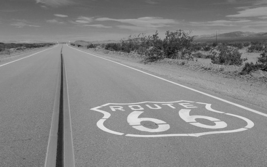
Route 66 Historic Backcountry Byway, Arizona
This 42-mile stretch of two-lane blacktop is one of the last and best-preserved segments of the original Route 66, one of America's first transcontinental highways. This portion of the highway once included one of the most fearsome obstacles for "flatland" travelers in the 1930's: the hairpin curves and steep grades of Sitgreaves Pass, which characterize Old Route 66 as it makes its way over the Black Mountains of western Arizona.
Bodie Hills, California
Always on our #roadtrip #bucketlist! California’s Eastern Sierra region is a dramatic transition zone between the snow-capped granite spires of the Sierra Nevada and the endless sagebrush covered uplands of the Great Basin. A trip at the right time of year will reward visitors with a diversity of wildflowers.
One great wildflower viewing area is just north of Mono Lake and east of Yosemite National Park in the rolling Bodie Hills – hills being an understatement since they top out at over 10,000 feet! Because of their high elevation, wildflower blooms are later here than much of California – typically arriving in May-June on the lower slopes and into July on the highest peaks. Several back roads traverse the area and offer access to view the displays of phlox, penstemon and paintbrush to name a few of the many wildflower species. More than 100,000 acres of BLM lands cover most of the Bodie Hills and include several wilderness study areas.
Bodie State Historic Park is the best-preserved ghost town in California, and arguably in the United States. Wildlife viewers can see antelope, mule deer, and if lucky, get a glimpse of a sage grouse. If you visit later, around early October, crisp clear nights will turn the scattered aspen stands to gold, giving a second opportunity to see Bodie Hills in color.
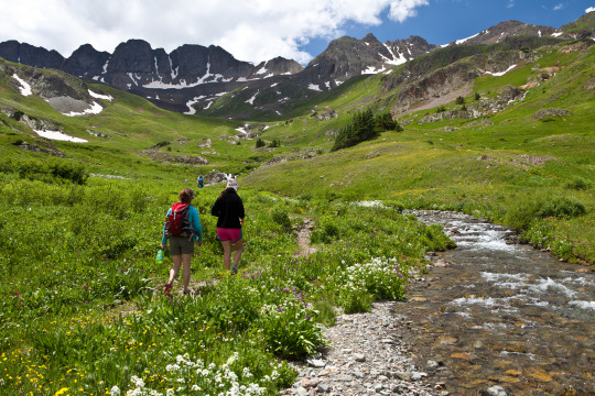
Alpine Loop National Backcountry Byway, Colorado
A #roadtrip to the #AlpineLoop should be on your #bucketlist for 2018! Located northeast of Silverton, Colorado in San Juan and Hinsdale counties, the Alpine Loop Back Country Byway is a premiere visitor destination. The epic scenery draws off-highway-vehicle enthusiasts across the country who are treated with a network of roads that climb above the timberline, accessing unparalleled vistas in an alpine environment. The hiking, biking and camping in the area is also fantastic. Scattered along the Alpine loop are remnants of our nation’s frontier history, where visitors can learn about the bustling mining towns that once thrived here.
While many roads are accessible by regular, two-wheel drive vehicles, getting into the alpine areas require high-clearance, four wheel drive vehicles. Plan your trip accordingly.
Washington-Rochambeau Revolutionary Route National Historic Trail, Virginia
Journey through early American history and walk in the footsteps of our nation’s founding fathers as you explore the Washington-Rochambeau Revolutionary Route. This National Historic Trail commemorates over 680 miles of land and water trails followed by the allied armies of General George Washington and the French Lieutenant General Comte Jean de Rochambeau. During their 1781 march from Newport, Rhode Island to Yorktown, Virginia, the French army established an encampment on what is now the Meadowood Special Recreation Management Area (SRMA). A segment of this trail connects with a BLM system of trails crossing the SRMA on the historic Mason Neck Peninsula, just a short drive from the nation’s capital. At Meadowood, the trail transects open meadows, enters into mature hardwood forests, and crosses riparian wetlands. While in the area, visit Gunston Hall, the home of Founding Father George Mason, a strong supporter of individual liberties and the author of the Virginia Declaration of Rights. Many of the concepts in that document found embodiment in the first ten amendments to the U.S. Constitution, the Bill of Rights.
Lewis and Clark Backcountry Byway, Idaho
The Lewis and Clark Backcountry Byway and Adventure Road is a 36-mile loop drive through a beautiful and historic landscape following the Lewis and Clark National Historic Trail and the Continental Divide National Scenic Trail. Experience incredible views of the Lemhi Valley and the surrounding mountain ranges; truly some of the finest scenery in America!
The mountains, evergreen forests, high desert canyons and grassy foothills look much the same today as when the Lewis and Clark Expedition passed through in 1805. Take a slow and meandering journey along this drive with time to stop along the way for hiking, fishing, mountain biking and exploration. With a 4,000 foot gain and loss in elevation, expect some steep grades too.
Lemhi Pass is well-known for its wildflower displays in the spring and summer. Captain Lewis collected three new plant species in this area: mountain maple, common snowberry and Lewis’s monkey flower. You might see elk, mule and whitetail deer, black bear, moose, pronghorn antelope, coyotes and many smaller mammal species. Early mornings and evenings are the times to look for wildlife, particularly where the forest and meadow meet.
By late September, shorter days and cooler temperatures release hues of red, yellow, and gold in aspens, cottonwoods, willows and shrubs. Don’t miss Agency Creek in October – it’s beautiful! Download a visitor guide for your roadtrip from our website.
Big Sky Byway, Montana
The 105-mile Big Sky Back Country Byway begins in Terry, MT, and travels north and south covering badlands and rolling prairies. The byway ends in Wolf Point, MT, on the beautiful Missouri River, part of the Lewis and Clark National Historic Trail. The route is part of the National Scenic Byways Program, linking Terry with Wolf Point. Taking 2 hours one way, you can stop to take a look at the information kiosks in Terry, Circle, and Wolf Point, which describe byway attributes, local history, and culture. Visitors can enjoy the scenic badlands of eastern Montana year round from this all-weather road.
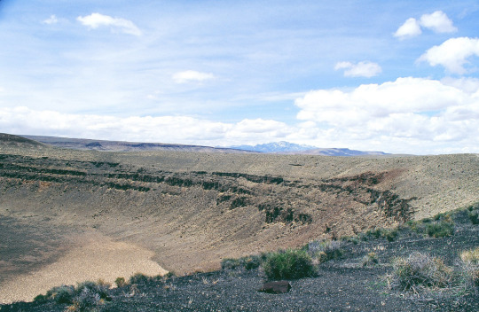
Lunar Crater Backcountry Byway, Nevada
The scenic loop (the Lunar Crater Back Country Byway) passes by the crater with a stopping point near the crater where visitors can get out to view the impressive volcanic feature. Vehicles are limited to existing roads and trails.

Lake Valley Backcountry Byway, New Mexico
A meandering 48-mile drive on paved roads takes visitors through ranching and mining country and past the ruins of the 1880s mining town of Lake Valley. The Lake Valley Backcountry Byway is nestled between the Mimbres and Caballo Mountains and the Cooke's Range in southwestern New Mexico and offers spectacular scenic views. Rich in history and scenery, the Byway offers an outstanding trip for travelers with an hour to spare.
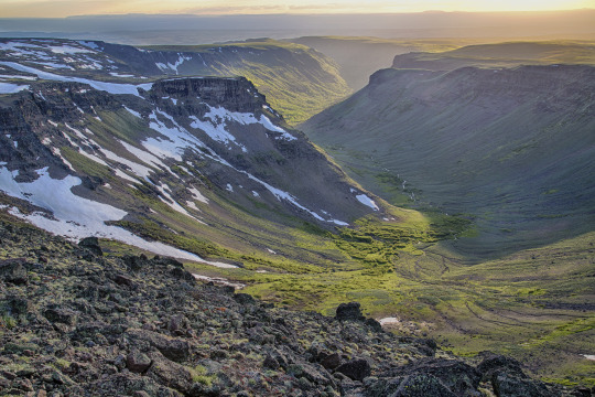
Steens Mountain, Oregon
How about this for a scenic byway: Glacier-carved gorges, pristine alpine lakes and wild and scenic rivers, all accessible via the highest elevation road in Oregon!
Come take a drive on the 52-mile-long Steens Mountain Backcountry Byway! There are four campgrounds along the byway for those wanting to stay a little bit longer in one of the most remote places in the U.S.!
Photo/video: https://goo.gl/VOkTFg
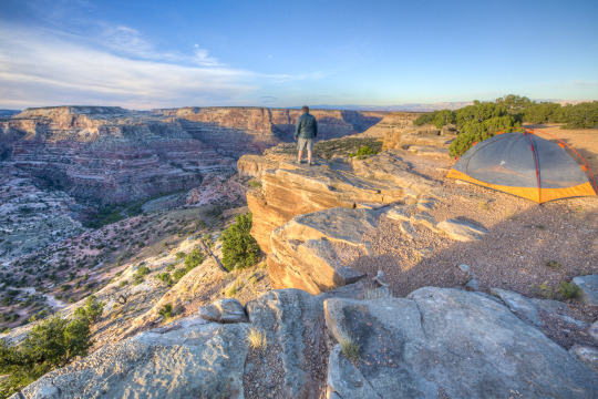
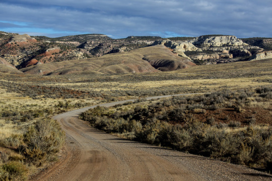
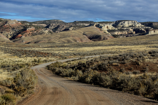
San Rafael Swell, Utah
Make the most of your road-trip to Moab or the Skyline Drive! Take the scenic route through the San Rafael Swell. Emery County Road 332 is a gravel road that connects approximately 45 miles between Huntington, Utah to Interstate 70 in the heart of the San Rafael Swell. Enjoy the amazing desert scenery, stop at the wedge overlook for a view of the “Little Grand Canyon,” view the ancient rock art of the Buckhorn Draw Panel, and maybe even take a side trip to the Cleveland-Lloyd Dinosaur Quarry. While there is primitive-style camping in the area, there are no other services. Come prepared with everything you need, and take home everything you bring. Flat tires are common.
Red Gulch/Alkali National Backcountry Byway, Wyoming
The Red Gulch/Alkali National Backcountry Byway is a 32-mile scenic drive on improved gravel and dirt roads through the foothills of the Bighorn Mountains. Near each of the two entrances to this historic route you will see a National Backcountry Byway kiosk which provides historical information about the byway as well as road conditions. The steep, rugged canyons cut into the mountains along the byway and offer many challenging and interesting hiking opportunities. Among the wondrous sights you may see are hoodoos. These strange, artistic rock formations were carved over the centuries by Wyoming’s wind.
#bureau of land management#explore#yourpubliclands#recreation#roadtrip#byway#outdoors#getoutdoors#outside#newyearnewadventures#newyear#2018#solitude#nature#photography#wilderness#alaska#arizona#california#colorado#virginia#idaho#montana#nevada#newmexico#oregon#utah#wyoming
42 notes
·
View notes
Text
7 Southern Hemisphere Rentals Where You Can Beat the Heat This Summer
As summer approaches, there’s one thing on everyone’s mind: a fantastic vacation.
But this year, skip the tried-and-true beach destinations and head to the Southern hemisphere for a cold-weather escape. Here, winter lasts from June to September, so you can get your fix of the outdoors, without breaking a sweat.
From the mountains of Australia to the ice fields of South America, we’ve highlighted six cool rentals, perfect for beating the heat. They offer breathtaking views, soothing hot tubs, and wood-burning fireplaces, while allowing you to enjoy winter at its best. Choose a place from our list and chill out on vacation this summer.
On the Lake 4 Bedroom With Indoor BBQ | San Carlos de Bariloche, Patagonia, Argentina
Don’t let the lack of snow in photos of this magical home fool you. It’s located at the edge of Lake Nahuel Hapi, just a short drive from the snow-covered slopes of Cerro Catedral. After a day skiing, warm up by the fire or use the indoor parrilla (grill) to barbecue a hearty homemade meal. This beautiful lake home combines rustic charm with modern conveniences, which makes for a memorable stay.
The Eastern | Thredbo Village, Australia
The Eastern is perfect for vacationers looking to experience winter in the Southern hemisphere. It’s situated at the foothills of Mt. Kosciuszko and boasts panoramic views of the Australian Alps. Amenities like heated floors, ski storage, and luxurious linens make this sleek rental extra special. Past visitors have said it’s “beautiful, down to the smallest touches,” and we’re sure you’ll agree!
Spacious and Relaxing Mountain Loft | San Martin de los Andes, Patagonia, Argentina
Planning to spend your vacation skiing? Then book this rustic mountain loft and have the slopes at your doorstep. It offers ample space to relax, while its warm ambiance is inviting after a busy day outdoors. Floor-to-ceiling windows throughout the house provide glimpses of the surrounding woods and the enormous fireplace in the living room is the ideal place to take it all in. The perfect end to the day? Everyone gathered around the large family table, glass of wine in hand.
Isla Macias Retreat | Puerto Rio Tranquilo, Chile
Disconnect from the day-to-day at Isla Macias Retreat. Built of native wood, this private home sits on the shores of Chile’s General Carrera Lake and sleeps up to 10 guests. It’s near some of the region’s most impressive attractions, including the Marble Caves, the Exploradores Glacier, and the San Rafael Lagoon. Whether you’re gawking at the magnificent landscape or dodging falling chunks of ice at nearby glaciers, you won’t soon forget a visit to Puerto Rio Tranquilo!
The Church at Fox | Fox Glacier, New Zealand
Fox Glacier has everything you need for a cold-weather escape: heli-hiking, glacier tours, ice climbing… you name it! Bundle up and experience all of the outdoor activities the region has to offer, then make your way home to the Church at Fox. Recently restored and fully-stocked, guests describe this unique church-turned-vacation rental as “absolutely stunning” and having the “wow factor.” It’s the perfect rural retreat in New Zealand’s Westland National Park.
Amazing 4 Bedroom Chalet in Villa Traful | Villa Traful, Patagonia, Argentina
Exposed wood beams, a natural stone fireplace, and floor-to-ceiling windows allow visitors to co-exist with nature at Villa Trafu. It’s located in Nahual Huapi National Park and offers all the comforts of home after a day of outdoor adventures. Plan a trip here during the winter to truly escape the stresses of everyday life. This part of Patagonia is sparsely populated during the winter months, so you can enjoy the area’s natural beauty all to yourself!
Alpine Vista, 3 Level Home With Magnificent Views | Queenstown, New Zealand
Alpine Vista is the perfect base for a cozy winter getaway. In this luxury Queenstown home, you’ll wake up to stunning views of snow-capped mountains. And before heading to bed, you’ll love settling in around the fireplace for a quiet night at home. No matter what room you’re in, massive picture windows bring nature indoors, creating a peaceful place to relax.
The post 7 Southern Hemisphere Rentals Where You Can Beat the Heat This Summer appeared first on The FlipKey Blog.
from The FlipKey Blog http://ift.tt/2pvqcEr
2 notes
·
View notes
Text
California roads not designed to handle wildfire evacuations
PARADISE, Calif. — Californians got a deadly wakeup call when more than 27,000 Paradise residents trying to escape the Camp Fire got caught in a nightmare traffic jam. The 2018 catastrophe illuminated the grim reality that road systems throughout the state are not designed to handle a sudden evacuation.
A new USA TODAY Network-California analysis reveals the extent to which a fundamental problem in Paradise — too few escape lanes for too many people in vehicles — applies to other cities and neighbourhoods at great risk of wildfire across the state.
About 350,000 Californians live in areas that have both the highest wildfire risk designation, and either the same number or fewer exit routes per person as Paradise. From the mountains, lakes and forests of northern California, to the San Diego suburbs, some residents in the most fire-prone areas have far fewer evacuation routes than the vast majority of the state.
The ratio of people to exit routes doesn’t account for all the complexities of an actual evacuation, experts say, but it does serve as a shorthand for evaluating evacuation efficacy.
In the Gold Rush town of Sonora, about three and half hours southeast of the town wasted by the Camp Fire, Karl Rodefer thinks about Paradise. He worries more as the next dry season approaches.
“If that happens here, we’re going to have the same kinds of issues,” said Rodefer, a Tuolumne County supervisor. “There’s a lot of anxiety in the foothills now because of the Camp Fire.”
Both Sonora and Paradise are isolated communities with few roads leading into and out of town.
In Los Angeles County, an area already known for gridlock, the city of Glendale straddles the Verdugo Mountains with neighbourhoods, schools, and hiking trails carved into its base. The city’s 2008 emergency plan identified them as potential brush fire zones.
The roads can be narrow and some communities have only one way in and out. The plan notes that these conditions could make evacuation and emergency response difficult, but years of construction and development have made any kind of road widening “physically impossible” in those areas, city spokesman Dan Bell said.
The city’s police and fire agencies have conducted outreach in these communities and are strict about defensible space around homes. There’s also a new, targeted alert system.
“I think the only concern is people not evacuating when we ask them to evacuate,” he said.
Plus, Bell said, the area hasn’t seen a major wildfire in some time.
But it’s the big one that worries Glendale resident James Ward, 62. For 32 years he’s lived in Chevy Chase Canyon, a community of 1,600 homes in a cleft of the San Rafael Hills, which the city has also identified as a potential brush fire zone.
There are only two-lane roads that run through the canyon, with a single access point for many streets and only a few main arteries that let people out. But some neighbours don’t know all the ways out, Ward said.
“If 80% or 60% of the people thought the only way was Chevy Chase (Drive) and all the emergency vehicles were coming up, yes that’s gonna be an issue,” Ward said.
Evacuation routes came up at an annual community meeting in March with the police and fire departments because residents saw the tragedy in Paradise and had the same fears, Ward said. The co-president of the Chevy Chase Estates Association said the public safety officials acknowledged their fears but “their message was: be aware of your surroundings and if we ask you to leave, leave.”
California officially adopted fire code standards for roads in the 1990s, although they had been used in some areas for decades before that. They set rules for things like grades, road surfaces, passing areas, signage on dead-ends and “critical” secondary access to any subdivision, said Daniel Berlant, assistant deputy director with Cal Fire’s office of the state fire marshal.
But most of the road systems California communities like Glendale rely on were built before the widespread use of the standards.
There are also building codes that regulate room capacity and emergency exits, said wildfire evacuations expert Tom Cova. The same consideration should be applied to road infrastructure in communities, he said.
“We’re gonna see a lot of bad things happen I think … before we do something for communities that we did for buildings,” said Cova, director of the University of Utah’s Center for Natural and Technological Hazards.
Still, Cova and other experts see road capacity as just one element of a healthy evacuation system. Timely evacuation orders, residents’ willingness to obey them, traffic pinch points at intersections beyond the community and many other factors can also be a matter of life and death.
And road capacities can be sufficient, Cova said, if evacuations are gradual or limited. It’s when everyone tries to leave at once that escape routes are quickly overwhelmed.
——
‘THERE WERE JUST SO MANY PEOPLE’
Malibu transplant Kassidy Jones, 40, said that’s exactly what happened when he and his family fled their home in the city’s Corral Canyon neighbourhood the morning of Nov. 9. As the Woolsey Fire bore down, they packed two cars full of belongings and drove south down the windy, two-lane road to scenic Pacific Coast Highway. At the bottom of the canyon, they found bumper-to-bumper traffic.
“I don’t think there’s really another way out, especially because the fire was coming down the mountain,” Jones said. “There were just so many people. PCH can’t handle it.”
Work brought the Texas native to Los Angeles, but he never liked the city much. That’s why he moved his family to the remote neighbourhood where his backyard met the sprawling canyon and gave him a glimpse of the Pacific Ocean.
Now there he was stuck in traffic. He couldn’t go north. The flames were coming from that direction — just like in previous fires. Plus, north of Jones, the canyon road eventually empties into a network of hiking trails.
At the bottom of the canyon, it took 20 minutes to even turn onto the highway, Jones said. He parked one of the vehicles along PCH and planned to leave it there, figuring the fire wouldn’t spread that far. There, Jones rejoined his wife and their children, ages 6 and 8.
The kids became restless as the family’s car crept along the highway for two hours to go just two miles. Finally, they stopped at a park to stretch their legs, go to the bathroom and have some snacks.
They watched as the towering smoke plume from the Woolsey Fire changed direction.
“Before it was flowing west then it went south. Our neighbourhood was on the western edge of where the fire went. Unfortunately, it got our house,” Jones said.
——
WHERE DRIVERS COULD OVERWHELM EVACUATION ROUTES
For others like Jones, who choose to live in places prone to fire, whether in remote parts of rural California or in the “urban-wildland interface” that buffers California’s rugged wilderness and dense cities, a similar situation could await.
A USA TODAY Network-California analysis of populations, fire risk zones and roadways shows roughly one out of every 100 ZIP codes in California has a population-to-evacuation-route ratio that is near to or worse than that of Paradise and its neighbour Magalia.
Near the top of the list is South Lake Tahoe, a city west of the California-Nevada state line where vacationers come to camp along the lake that straddles both places. The town is relatively isolated, with only a few thoroughfares to facilitate emergency access for firefighting resources.
There, the number of people living in the “very high fire hazard safety zone” per roadway lanes out is almost three times the number for Paradise.
Interim South Lake Tahoe Fire Department Battalion Chief Jim Drennan said he wasn’t surprised to find out his community is in one of the most precarious fire evacuation locations in the state, given the small number of roads in and out of the Tahoe Basin.
Drennan said since Paradise burned, he hears the same question from people on a nearly daily basis: What are they going to do if a major fire breaks out? Evacuation plans fall primarily to police, he said, but his fire department is one of several agencies trying to plan for what feels like a looming threat. His fire department and other public safety agencies in the area are “on super high alert,” he said.
“The mindset here is: There’s no earthly way you’re moving the entire vacation population out of the basin all at once,” Drennan said. “If you have just one quirk, you’re going to end up with a lot of people stuck on the roads.”
The previous fire chief there wrote in a 2018 op-ed that it’s not a question of “if” but “when” a major fire will hit the area, and he pointed out the limited evacuation routes as a major concern.
Police, fire and city officials will hold a public meeting April 25, specifically to discuss fire preparedness and evacuation planning, partly in response to the anxiety many have expressed to him and others, Drennan said.
The Palos Verdes Peninsula in Los Angeles County, densely populated with some of the costliest real estate in the United States, has even more people and fewer lanes leading out, putting it at more than five times the population-to-lane ratio as Paradise.
The western-facing edge of the Sierra Nevada mountain range is full of areas with a low number of evacuation routes for the populations there. Places like Foresthill in Placer County, which has a worse population-to-lane ratio than Paradise, and Nevada City in Nevada County, and Sonora in Tuolumne County, are far worse than average.
The analysis identified some places in California where fires have already combined with jammed roadways, killing drivers attempting to flee. Paradise and its neighbour Magalia were among the areas identified as a populous area with limited routes out, and 2018’s Camp Fire proved the point. There, city and county officials had planned on having motorists evacuate using five two-lane roads and one four-lane road leading out of town. But fire forced officials to close three of those routes, further clogging the remaining roads, Paradise Mayor Jody Jones said.
The Cedar Fire, which burned 273,000 acres across the hills of northeastern San Diego in 2003, claimed 10 people trying to flee the blaze in their cars. The fire lashed the densely populated Scripps Ranch area, which has a limited number of roadways that lead to less fire-prone areas.
——
UNDETERRED
Many Californians clearly understand the risks. They’ve lived through wildfire evacuations, or have watched others. But that’s not enough to pry them from the places they love.
Greg Meneshian, 53, is one. He’s rebuilding the Bell Canyon home destroyed last year by the Woolsey Fire.
Meneshian moved to the gated, equestrian-oriented community just west of the bustling San Fernando Valley about five years ago. The sense of community he felt the night he evacuated, he said, is just more reason for him and his two daughters, 10 and 12, to stay.
There’s only one access point for the neighbourhood of 750.
Looking northwest from his driveway on the night of Nov. 8 he could see flames in the canyon. He and his neighbours met on the street in front of his home trying to figure out what they should do, Meneshian said.
“They were looking to me for answers as if I lived through this before,” Meneshian said. But he was in disbelief.
He woke up the girls and told them to pack a bag for a week. The power had been flickering on and off, and Meneshian knew that meant it was time to go.
Unlike Jones, whose wife had gotten an evacuation alert, Meneshian left before anyone told him to.
It was dark and smoky with nothing but the pockets of fire visible in the canyon, Meneshian said. Vehicles raced down his hilly street.
“It was really a scramble for our lives,” Meneshian said.
He’d find out the next day his home was destroyed.
But the self-proclaimed “nostalgic guy” likes the sense of togetherness in Bell Canyon, where the closest store is 30 minutes away so sometimes borrowing from a neighbour is usually the better bet.
The limited escape routes, he thinks, are just something to be aware of: “It’s probably a deterrent for some people (moving) in,” he said. “But it shouldn’t be.”
——
‘YOU HAVE TO MAKE THESE INVESTMENTS’
Before Paradise burned, there were already signs of problems with evacuation routes during major wildfires, said Assemblywoman Laura Friedman, whose district includes Glendale.
The 2017 Tubbs Fire in Santa Rosa, which killed 22 people and destroyed more than 5,600 structures, raised alarms.
Afterward, Friedman and her staff talked with academics about the lessons learned, and she introduced Assembly Bill 2911, which then-Gov. Jerry Brown signed into law in 2018. Among other things, AB 2911 requires that subdivisions with only one exit route, located in very high hazard zones for wildfire, undergo an assessment. The bill calls for developing safety recommendations.
State fire officials should begin the surveys around July 1, 2021, and continue every five years after.
Friedman’s bill is likely to have an impact back in her district. In Glendale’s 2008 emergency plan, bold, capitalized letters call attention to the Oakmont Woods and Whiting Woods communities and their single access roads. Both are within the state’s very high hazard zone.
“Any city that has those conditions could benefit and certainly it could be a legislative wake-up call to not only identify these areas but (to signal that) you have to make these investments to make the cities safer,” Friedman said.
Friedman hopes for more state funding for the assessments. She sees reason for optimism in Gov. Gavin Newsom’s declaration of a state of emergency ahead of the traditional wildfire season.
While there’s no unified approach to dealing with California’s wildfire evacuation problem, Friedman’s bill calling for assessments to begin two years from now is not the only potential improvement underway.
In March, Newsom fast-tracked 35 priority projects to remove years of dry, built-up vegetation and create fuel breaks for emergency routes. Those follow an effort by Caltrans since 2016 to remove dead and dying trees from state roadways.
—-
MORE THAN JUST LANES
Cova, the wildfire evacuations expert, said 25 years ago he became preoccupied with the idea that road congestion was the problem. But through his research he also learned it’s more complicated.
The direction the roads let out is also important. In most fire-prone areas officials know what historically contributes to large wildfires, such as Santa Ana or Diablo winds, and can plan to build roads in a direction those gusts are unlikely to push the fire, Cova said.
During an emergency, Cova said traffic routing and control makes a big difference. That can be especially important at the points where evacuation routes hit other roads. The Malibu example, where so many roads empty onto PCH, is apt.
The road issues are important because so many other human factors may decrease the amount of time people have to evacuate, he said.
“What really causes the problem is when you have too many people leaving in too little a time,” Cova said.
It can take officials a while to order evacuations. And residents often hesitate, contemplating whether they should leave, then take time packing.
Back in Malibu, Jones’ wife got an evacuation alert on her phone at 6 a.m. Sheriff’s officials came around on a loudspeaker at 7 a.m. It was around 8 a.m. when Jones actually left.
To speed things up, Cova encourages residents to have a go bag with medications, important paperwork, photographs and other irreplaceable items. And they should have a plan to round up pets, since critical time can be lost chasing dogs and locating cats.
“Being prepared to leave at a moment’s notice is a good idea,” Cova said.
——
Damon Arthur of the Redding Record Searchlight contributed to this report.
from Financial Post http://bit.ly/2GwDfz9
via IFTTT Blogger Mortgage
Tumblr Mortgage
Evernote Mortgage
Wordpress Mortgage
href="https://www.diigo.com/user/gelsi11">Diigo Mortgage
0 notes
Text
Mons Royale
Reimagining a Classic: A Sail-to-Ski Adventure in Chilean Patagonia
Sept-Oct 2015

The voyaging skier’s bucket list indubitably boasts a few classic destinations: Japan, Chamonix, Alaska, New Zealand, South America. They all have their unique experiences, stories we share and compare with others who have made the same journey.
Sometimes, however, the opportunity arises to take on one of these mountain Meccas in an unorthodox manner. It means risking the security of the tried and tested itineraries, but it also guarantees an experience unlike anything you could have expected. This September I was given the chance to do just that when my friend Dwyer invited me to join him on his small yacht, the Rascal, for two months in southern Chile.

Having spent two years navigating his way singlehanded from Seattle to Puerto Montt, he was reaping the delights of the Andean winter. My visit would be a spring mission with a twist, in which we would try to access skiable terrain, in the depths of Patagonia, from a sailing boat. Our primary objective was the San Rafael glacier, a tidewater glacier that runs directly into the sea and, incidentally, the nearest tidewater glacier to the equator. If we were going to ski from the boat anywhere, this was certainly a good place to try.

Photo: Dwyer Haney (voyageoftherascal.com)
Setting out from Puerto Montt we took to the seas and sailed south through the nearly deserted fjords of Chilean Patagonia. Although we never lost sight of land, the only signs of civilisation were remote salmon farms, the odd fishing village and long distance ferries, one of which was exposed to the sight of our glaringly pale behinds floating by. As we sailed, snow-laden peaks drifted past us in the distance, all of them protected by a barricade of densely forested foothills. Accessing them was not going to be a walk in the park.

Fortunately the north winds we needed to carry us south were prevalent, bringing with them heavy winds and rain or beautifully textured overcast skies. Finally, after thirteen days, we sailed in to the Laguna San Rafael, the sinking sun lighting up a panorama of colossal, ornate icebergs while the glacier glowed brightly in the background.


We spent a week among the icebergs, motoring around in our inflatable dinghy, watching in awe as the glacier shed towering blocks of ice into the water, and hiking through the forest to reach incredible viewpoints.

Photo: Dwyer Haney (voyageoftherascal.com)


On our last day we loaded the dinghy with our ski gear, beached it near the base of the glacier and navigated over moss blanketed rocks up to a relatively smooth patch of ice. Hiking up a small face with our crampons, we ripped a few glory turns on the sun softened ice, took a plunge in a glacial pool and celebrated with a champagne picnic at the edge of the glacier’s headwall. It wasn’t exactly extreme skiing, but we’d achieved our first goal of the trip, and we’d done it in glorious style.

Photo: Dwyer Haney (voyageoftherascal.com)

Photo: Dwyer Haney (voyageoftherascal.com)

The following day we began our journey back north. Blessed with an unusual stretch of sunshine and favourable winds we enjoyed productive days of sailing. While Carly, our autopilot, supervised our rapid progress we played cribbage, drank wine and held impromptu dance parties on deck. Before long we were only two days south of Puerto Montt and in the vicinity of the perfectly conical, snow-capped Volcan Hornopiren. Despite the dense forest that covered the majority of the mountain, it’s smooth upper slopes beckoned to us and once more we dug our ski gear from the storage lockers.


Some recon in the town of Hornopiren told us of a trail starting 10km out of town, so the next day we awoke early and ventured ashore to find it. The ascent that ensued was a six hour battle for the books. What started as a cleared trail quickly turned into a painstaking struggle through the dense Patagonian undergrowth. At long last we reached the snow line, switched to our ski boots and cranked out the final, arduous boot pack to the summit.


Photo: Dwyer Haney (voyageoftherascal.com)
With a mixture of relief and awe we took in the panoramic view from the top. Glaciated volcanic peaks lined the horizon while nearby fjords gleamed in the low afternoon sun. Dropping in to the slope we reaped our well earned bounty, lapping up creamy, sun-softened turns while our lengthening shadows danced around us. However, we now faced a long, technical descent with limited hours of daylight. Pushing on as fast as safely possible we made it down, finding the cleared path just as the light was fading, and emerging onto the main road under a brilliant full moon. The following days were spent nursing our sore muscles in scenic hot springs before embarking on the final stretch back to Puerto Montt.


Photo: Dwyer Haney (voyageoftherascal.com)

We had spent six weeks and over 800 nautical miles immersed in the rugged wilderness of Patagonia. We gained a serious respect for the pristine seascapes we sailed through, the wildlife that makes these fjords their home, and the hidden mountains that will allow you to explore them if you’re prepared to earn it. It was a South American ski trip unlike any I could have expected, one that pushed my limits far beyond their expected elasticity and inspired me to keep seeking the next adventure.


Photo: Dwyer Haney (voyageoftherascal.com)
0 notes
Text
7 Southern Hemisphere Rentals Where You Can Beat the Heat This Summer
As summer approaches, there’s one thing on everyone’s mind: a fantastic vacation.
But this year, skip the tried-and-true beach destinations and head to the Southern hemisphere for a cold-weather escape. Here, winter lasts from June to September, so you can get your fix of the outdoors, without breaking a sweat.
From the mountains of Australia to the ice fields of South America, we’ve highlighted six cool rentals, perfect for beating the heat. They offer breathtaking views, soothing hot tubs, and wood-burning fireplaces, while allowing you to enjoy winter at its best. Choose a place from our list and chill out on vacation this summer.
On the Lake 4 Bedroom With Indoor BBQ | San Carlos de Bariloche, Patagonia, Argentina
Don’t let the lack of snow in photos of this magical home fool you. It’s located at the edge of Lake Nahuel Hapi, just a short drive from the snow-covered slopes of Cerro Catedral. After a day skiing, warm up by the fire or use the indoor parrilla (grill) to barbecue a hearty homemade meal. This beautiful lake home combines rustic charm with modern conveniences, which makes for a memorable stay.
The Eastern | Thredbo Village, Australia
The Eastern is perfect for vacationers looking to experience winter in the Southern hemisphere. It’s situated at the foothills of Mt. Kosciuszko and boasts panoramic views of the Australian Alps. Amenities like heated floors, ski storage, and luxurious linens make this sleek rental extra special. Past visitors have said it’s “beautiful, down to the smallest touches,” and we’re sure you’ll agree!
Spacious and Relaxing Mountain Loft | San Martin de los Andes, Patagonia, Argentina
Planning to spend your vacation skiing? Then book this rustic mountain loft and have the slopes at your doorstep. It offers ample space to relax, while its warm ambiance is inviting after a busy day outdoors. Floor-to-ceiling windows throughout the house provide glimpses of the surrounding woods and the enormous fireplace in the living room is the ideal place to take it all in. The perfect end to the day? Everyone gathered around the large family table, glass of wine in hand.
Isla Macias Retreat | Puerto Rio Tranquilo, Chile
Disconnect from the day-to-day at Isla Macias Retreat. Built of native wood, this private home sits on the shores of Chile’s General Carrera Lake and sleeps up to 10 guests. It’s near some of the region’s most impressive attractions, including the Marble Caves, the Exploradores Glacier, and the San Rafael Lagoon. Whether you’re gawking at the magnificent landscape or dodging falling chunks of ice at nearby glaciers, you won’t soon forget a visit to Puerto Rio Tranquilo!
The Church at Fox | Fox Glacier, New Zealand
Fox Glacier has everything you need for a cold-weather escape: heli-hiking, glacier tours, ice climbing… you name it! Bundle up and experience all of the outdoor activities the region has to offer, then make your way home to the Church at Fox. Recently restored and fully-stocked, guests describe this unique church-turned-vacation rental as “absolutely stunning” and having the “wow factor.” It’s the perfect rural retreat in New Zealand’s Westland National Park.
Amazing 4 Bedroom Chalet in Villa Traful | Villa Traful, Patagonia, Argentina
Exposed wood beams, a natural stone fireplace, and floor-to-ceiling windows allow visitors to co-exist with nature at Villa Trafu. It’s located in Nahual Huapi National Park and offers all the comforts of home after a day of outdoor adventures. Plan a trip here during the winter to truly escape the stresses of everyday life. This part of Patagonia is sparsely populated during the winter months, so you can enjoy the area’s natural beauty all to yourself!
Alpine Vista, 3 Level Home With Magnificent Views | Queenstown, New Zealand
Alpine Vista is the perfect base for a cozy winter getaway. In this luxury Queenstown home, you’ll wake up to stunning views of snow-capped mountains. And before heading to bed, you’ll love settling in around the fireplace for a quiet night at home. No matter what room you’re in, massive picture windows bring nature indoors, creating a peaceful place to relax.
The post 7 Southern Hemisphere Rentals Where You Can Beat the Heat This Summer appeared first on The FlipKey Blog.
0 notes
Last Seen Blogs

grungegalactica
we'll carry on
grungegalactica
we'll carry on

asiangirlshittingbongs
Asian Girls Hitting Bongs

photographing-yourdreams
You are perfect

sup227
Untitled