#new madrid seismic zone
Text
Activity in the New Madrid Fault System
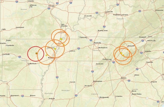
A new magnitude 3.8 earthquake struck near Ridgely, Tennessee at 3:19 this morning. It occurred during the overnight hours while everyone was asleep, so there were not many immediate reports coming in from residents feeling the tremor. A couple of small aftershocks immediately followed. It is interesting how this system was showing signs of becoming more active last month. There was a swarm of micro quakes happening up to mid April, but then it got totally quiet and then this happened.
0 notes
Photo
Today's Earthquake in Arkansas Serves as Reminder of New Madrid Seismic Zone Danger
A weak earthquake rattled northeastern Arkansas early this morning according to USGS, not far from the heart of the New Madrid Seismic Zone (NMSZ). According to USGS, the earthquake struck near Pleasant Plains between Little Rock, Arkansas and Memphis, Tennessee at 12:25 am from a depth of 4 km; it was rated a weak magnitude 1.8 event. Generally, earthquakes with a magnitude of 2.0 or greater can be felt by most people. Earthquakes generally need a much greater intensity than that to do any harm.
This earthquake was the 14th to strike in Arkansas, Missouri, and Tennessee near the Mississippi River Valley in the last 7 days. ...
... December 16 marks the anniversary of the first of three major quakes to strike the United States during the winter of 1811-1812, a violent time in seismological history of the region that scientists say will be repeated again.
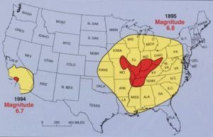
While the US West Coast is well known for its seismic faults and potent quakes, many aren’t aware that one of the largest quakes to strike the country actually occurred near the Mississippi River. On December 16, 1811, at roughly 2:15am, a powerful 8.1 quake rocked northeast Arkansas in what is now known as the New Madrid Seismic Zone. The earthquake was felt over much of the eastern United States, shaking people out of bed in places like New York City, Washington, DC, and Charleston, SC. The ground shook for an unbelievably long 1-3 minutes in areas hit hard by the quake, such as Nashville, TN and Louisville, KY. Ground movements were so violent near the epicenter that liquefaction of the ground was observed, with dirt and water thrown into the air by tens of feet. President James Madison and his wife Dolly felt the quake in the White House while church bells rang in Boston due to the shaking there.
But the quakes didn’t end there. From December 16, 1811 through to March of 1812, there were over 2,000 earthquakes reported in the central Midwest with 6,000-10,000 earthquakes located in the “Bootheel” of Missouri where the New Madrid Seismic Zone is centered.
The second principal shock, a magnitude 7.8, occurred in Missouri weeks later on January 23, 1812, and the third, an 8.8, struck on February 7, 1812, along the Reelfoot fault in Missouri and Tennessee.
The main earthquakes and the intense aftershocks created significant damage and some loss of life, although lack of scientific tools and news gathering of that era weren’t able to capture the full magnitude of what had actually happened. Beyond shaking, the quakes also were responsible for triggering unusual natural phenomena in the area: earthquake lights, seismically heated water, and earthquake smog. ...
... The February earthquake was so intense that boaters on the Mississippi River reported that the flow of the water there reversed for several hours.
The area remains seismically active and scientists believe another strong quake will impact the region again at some point in the future. Unfortunately, the science isn’t mature enough to tell whether that threat will arrive next week or in 50 years. Either way, with the population of New Madrid Seismic Zone huge compared to the sparsely populated area of the early 1800s, and tens of millions more living in an area that would experience significant ground shaking, there could be a very significant loss of life and property when another major quake strikes here again in the future.
1 note
·
View note
Text
North America may still be trembling with the aftershocks of two major earthquakes that struck the continent more than a century ago, according to new research.
If the statistical inferences that scientists have made are correct, then that means some tremors of today were set in motion way back in the 1800s, after some of the most powerful quakes in the continent's recorded history.
In fact, the study authors estimate that around 23 percent to 30 percent of the seismic shocks experienced in the New Madrid seismic zone between 1980 and 2016 were aftershocks of four large earthquakes that struck the area in 1811 and 1812, with magnitudes between 7.2 and 8.
What's more, another large quake, with a magnitude of 6.7 to 7.3, which hit Charleston, South Carolina in 1886, could explain up to 72 percent of the seismic shocks experienced in the region since.
The findings hint at the possibility that within geologically stable areas of continents, where there isn't a lot of tectonic activity, some earthquake aftershocks can continue uninterrupted for decades or even centuries, although far more research is needed before that controversial idea can be validated.
Continue Reading.
351 notes
·
View notes
Text
THESE MOUNTAINS SHOULD NOT EXIST
a rant/essay about dreamland's topography

disclaimer: i am a second year ENVS student and may get some details wrong. i don't really feel like sending this to my advisor (the local geologist) to proofread, so it'll have to do. i think she has more important things to do right now than read my kirby rant
to begin, we have to establish some basic rules about geology:
how do mountains form?
mountains come to be in a few ways: shifting plates and hot spots. hot spots are technically also to do with shifting plates, but we'll get to that later. let's talk about the plates first.
there are two kinds of tectonic plates: continental and oceanic. ocean plates are denser than continental plates, which means when an ocean and continental plate converge, the ocean plate will subduct under the continental plate. when two continental plates converge, because they are of similar density, they will collide. this process creates mountains.

mountains created by converging continental plates can be seen, for example, with the Himalayas. in this case, the mountains were formed by the Indian plate pushing up into the Eurasian plate. this method is off the table for dreamland because it is shown to be a peninsula (or at least a thin strip of land) surrounded by water.
ocean-continental convergence also creates mountains, but in a different fashion. this is the more relevant method because dreamland also has a volcano, an active one at that.
when ocean plates subduct under the land, they are forced down into the earth until they reach a melting point. sometimes this newly formed magma travels back to the surface, creating a hot spot. if this magma breaches the surface, it forms a volcano (that eventually cools into a mountain). this method can be seen in the Cascade mountains and the Andes.

the volcano/mountain's proximity to the coast depends on how steep the ocean plate's descent is. if we take a look at how close dreamland's mountains are to the shore...

...the ocean plate would have to be hitting its melting point almost immediately after subducting. forgive me for thinking this is unrealistic.
however, the inclusion of a volcano in this range is realistic! an O-C convergence would create a volcano like this. its portrayal within the show isn't really correct, but that's a post for a different day.
how this could potentially happen
not all hope is lost for the ocean-bordering mountain range, sort of. there are a few things that could have happened in popstar's history to cause something like this.
firstly, we should look at the Appalachian mountains. how did they get there? the North American plate is bordered on its east side by a mid-ocean ridge, where new crust is being created.
the Appalachians came to be around the time Pangea was coming together--the collision of the North American and African plates created the mountain range, and over time Pangea split apart, forcing the mountains away.
any map of tectonic plates will reveal a large split through the Atlantic ocean--this is a divergent boundary, where plates are being pushed apart in favor of creating new lithosphere (crust/upper mantle).
so, with all this in mind, there are a few things it could mean for our mountain range:
dreamland is actually an island, and we don't know because the overhead view doesn't show it
this would mean hot spots are relevant again: if a plate moves over a hot spot, magma can form into islands, especially volcanic ones. this is how Hawaii was formed, and why it is prone to volcanic activity. given that dreamland is an island, this would explain the presence of mountains. Hawaii's tallest peaks are still inland rather than right on the coast, but it's close enough.
2. a new fault/divergent boundary formed between dreamland's mountains and the opposing plate that created them
new faults aren't uncommon, though they don't always succeed. the New Madrid Seismic Zone, for example, made a small break in the American Midwest, but didn't get much farther than that. a successful fault or new divergent boundary could potentially push dreamland's mountains away from their neighboring plate. this is more like what happened to the Appalachians--though they're pretty far inland, so take that as you will. the new boundary would have to form quite close to the mountain range for them to be right on the shore like this.
3. the water has eroded away the land leading up to the mountains
now this isn't really one i have any backup for, i just wanted to throw it in because it came to mind. while it's possible for the ocean to have greatly eroded the land if it's been here for a long time, the mountains would still have to be very close to the shore to end up where they are. dreamland's proximity to the ocean could imply it has a delta at the end of the peninsula, and maybe one of the routes is along the mountains so the channel eats away at the shore for a while...who knows. but this one doesn't feel too realistic, either.
conclusion
as far as i'm aware, it isn't completely impossible for these mountains to exist, but they aren't exactly realistic, either. their proximity to the shore leaves too many questions that are hard to answer without any information about popstar's history and plate tectonics. most likely, dreamland is on an island, and was created as its plate moved over a hot spot. the existence of an active volcano implies that it is still sitting over this hot spot, and will eventually move away from it.
i must really miss my geology class if this is what i'm doing with my spare time. thank you for reading.
#kirby#kirby right back at ya#rhyn rambles#long post#i'm taking hydrology next term which means i might end up being annoying about something else soon#at the very least the river system looks pretty realistic#rivers are harder to mess up than mountains#i'll complain about the volcano if anyone's interested#i have some things to say that include comparing it to dante's peak
17 notes
·
View notes
Text
ok so no one was gonna tell me abt the new madrid seismic zone? and that id be in moderate damage and right by the lake so what if there was a lake tsunami... WHAT!
0 notes
Text


According to a 2013 study, the cumulative cancer risk from toxic air in southwest Memphis, which includes Boxtown, is four times higher than the national average, and driven by industrial and transportation-related pollutants like benzene and formaldehyde. [...] [J.S.] is a breast cancer survivor with a hunch about what made her sick. [J.S.], who is in her mid-60’s, has friends and neighbors who have also fought a myriad of cancers. They all live in Boxtown, the Southwest Memphis neighborhood that has seen many industrial facilities spring up during Smith’s lifetime. “This neighborhood always gets the brunt of whatever the other neighborhoods don’t want,” she said.
Boxtown is 99% Black, according to U.S. Census data. Located just south of T.O. Fuller State Park, it’s an area cloaked in kudzu that climbs the rolling hills of a mostly flat Memphis. The community got its name after freed slaves used scraps of materials and wood from train boxcars to build homes there in the late 19th century. In a five-mile radius around [J.S.]’s church in Boxtown [...] are at least 32 industrial facilities. To the west sit iron and steel mills; to the east, a pesticide manufacturer. A few miles north, between McKellar Lake and Nonconnah Creek, a Valero oil refinery pumps 195,000 barrels of oil per day.
Until 2018, the nearby Tennessee Valley Authority Allen Fossil Plant burned coal. A coal ash pond filled with waste material leftover from burning coal for electricity — which contains toxic heavy metals and radioactive materials — remains next to it. TVA’s own data shows that arsenic, a known carcinogen, was measured in one well at over 300 times the federal limit for drinking water.
Smith and her Boxtown neighbors have a new environmental hazard to worry about: In December 2019, subsidiaries of companies Plains All American Pipeline and Valero announced plans to build the Byhalia Connection oil pipeline through the neighborhood. [...]


The 45-mile project would link the 440-mile Diamond Pipeline, which brings crude from Oklahoma oil fields to Valero’s refinery in Memphis, to the 632-mile Capline Pipeline to transport oil from Illinois to the Gulf Coast. Most Boxtown residents found out about the project this year, via word-of-mouth, social media, or if a surveyor showed up on their land.
Nine months after Plains announced plans for the pipeline, about 30 people attended the Tennessee Department of Environmental Conservation’s first public meeting about the project. The meeting, held virtually Aug. 27 because of the coronavirus pandemic, was on a permit for water crossings in the state. That night, there was a tornado warning, and some residents reported they couldn’t attend because of Internet outages [...].
Plains All American has had a major spill in the past: The company faces criminal charges in California, where a pipeline ruptured in 2015, spilling 140,000 gallons of crude oil into the Pacific Ocean. A 2017 federal report found Plains at fault for lapses in safety measures. The area’s geology creates other risks. Memphis abuts the New Madrid Seismic Zone, the most seismically active area in the central and eastern U.S. [...]
But neither the company nor the state has plans to do a formal environmental impact statement for the project.
---
Photos, captions, and text published by: Leanna First-Arai. “This Black Memphis neighborhood is trying to stop an oil pipeline. They’re running out of time.” Southerly. 10 September 2020.
802 notes
·
View notes
Photo
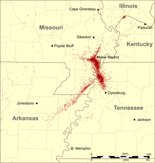
The New Madrid Seismic Zone
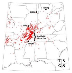
About once a year, residents of the counties at the border between Kentucky, Tennessee, Missouri, and Arkansas will feel the ground roll beneath their feet. This image maps out the location of earthquakes in this area over a 30-year period and clearly illustrates a major feature: the New Madrid Seismic Zone. This zone produces about 1 quake that can be felt per year in addition to many small earthquakes…and has historically produced really big ones.
The pattern of earthquakes clearly traces out a fault with 3 segments. This fault is not exposed at the surface; these earthquakes take place about 10 kilometers below the Earth’s surface on faults that are remnants of the continent’s ancient history.
The story of the New Madrid Seismic Zone begins over 1.5 billion years ago. The continent that would eventually become North America was growing by adding volcanic arcs onto the core that is today found in Canada, expanding outwards a block at a time, when something changed. The center of the growing continent began to pull apart, forming a long rift valley. That valley is named the “Reelfoot Rift”.
We don’t know exactly what all the plates were doing that long ago, but its clear that the continent started opening and things stalled. A comparison might be the East African Rift Zone today; the Arabian plate has fully pulled away from Africa to form the Red Sea, but East Africa itself is forming a deep, fault-filled basin loaded with volcanoes. If the East African rift shut down, it would eventually look a lot like the Reelfoot Rift.
The continent bears many scars from this rifting. There are igneous rocks throughout the area formed between 1.5 and 1.3 billion years ago. during this rifting Measurements of the gravity and magnetic fields over the rift also illustrate its presence. The modern Mississippi River even generally follows this valley today as the ancient faults still allow enough movement to make the rift zone a lowland in the continent’s center.
The faults formed during this rifting event don’t appear at the surface, they have been buried by sediments deposited by the Mississippi River system over the last 100 million years. The cities in the Central United States therefore sit mostly on top of fairly loose sediments that filled in these lowlands at the center of the continent.
This is the area that in the early 1800s suffered a surprising series of disasters. Three of the largest earthquakes in U.S. history occurred in the area between Missouri, Arkansas, Tennessee, and Kentucky over a period of about 3 months starting on December 16, 1811.
With earthquakes that occurred before modern seismic instruments were around to measure them it can be difficult to fully tell the story, but these events are important enough that scientists have assembled many details. See how there are 3 segments to the fault? You’ve already seen the reason why there were 3 quakes. The first quake took place on the southernmost segment and ruptured in a strike-slip motion. The second quake took place on the middle segment and ruptured a normal fault. The final quake took place on the northernmost segment and again had a strike-slip motion.
This structure therefore looks like a piece of the rift, a normal fault segment with two large strike-slip faults on its edge. The quakes were extremely powerful; USGS estimates place their moment magnitudes at 7.5, 7.7, and 7.7; comparable in strength to the 7.8 Mw 1906 San Francisco Earthquake. Because the crust in the Eastern U.S. is older and colder than that in the west, the shaking transmitted over a greater distance; historical records report the earthquakes caused church bells to ring as far away as Boston.
The quakes were a disaster for this area even though the population was sparse. The fault motion shifted the Mississippi River’s position, creating the modern Reelfoot Lake and also drowned and submerged many other areas. Sediments shifted and blew out of the ground across the region. Any structures present were likely destroyed, although there are very few remaining records. There was enough damage that a single landholder named John Hardeman Walker was able to cheaply buy up the affected land in the years following the quake as most of the inhabitants simply left. When Missouri became a state in 1818 he lobbied for inclusion of his land in Missouri at the expense of Arkansas, leading to the inclusion of 3 counties in Missouri as a “bootheel”. The New Madrid quakes therefore literally show up on the U.S. map.
Although these events are huge, they’re very much an anomaly. We teach that most major earthquakes are associated with boundaries between plates; even if the earthquake is happening far inland of the plate boundary it tends to relate to plate tectonics. The New Madrid quakes are so far from any plate boundary it’s extremely hard to say what is driving the motion on the faults.
There are ideas. We do know that plates can transmit stresses long distances as they move; the New Madrid area could be feeling the impact of stresses as far away as California. The New Madrid Area could also be responding to the change in mass on top of it from melting of the huge ice sheets 12,000 years ago. Finally, there are even proposals that a small mantle “hotspot” has interacted with the Central U.S. over the past few million years and that could contribute to stress on the New Madrid Faults.
These big quakes aren’t the only things this fault zone has produced. Not only do we see that earthquakes continue to this day, but scientists have also found evidence for previous earthquakes in the centuries prior to historical documentation. When these quakes happen, loose sand in the soil bursts onto the surface like a geyser, a feature called a “sand blow” or a “sand boil” (sand blows covering the land were probably a big reason why it was cheap to buy after the 1812 quakes). Older sand blows have been found indicating several large quake sequences happened on this fault before historical records were recorded, with the most recent ones happening about 1350 and 900 a.d. Furthermore, seismic techniques have been used to image the subsurface throughout the Mississippi valley and found evidence of faults across a broad area that have been active over the past few million years - not just these exact faults, but a multitude of them throughout the valley.
The sequence of prehistoric earthquakes and the ongoing smaller quakes is good evidence that this fault is still an active threat. If the smaller quakes were aftershocks of the 1812 sequence, there would be fewer of them with time; instead their rate is pretty much constant, suggesting they’re caused by continued stress on the fault.
Although the fault most recently ruptured about 400-500 years apart, there’s no reason why it can’t go sooner next time. In fact, during the US Geological Survey’s most recent earthquake hazard assessment, they increased their assessment of risk from this fault system due to the mapping of the prehistoric earthquakes.
If this fault system ruptures again, there are vastly more people in this area than last time. St. Louis, Memphis, and Nashville are all in the area that could see heavy shaking; smaller cities like Paducah, Jackson, Evansville would feel it as well, and smaller towns even closer to the epicenter could feel even stronger shaking.
Several factors would likely increase the damage to these cities even beyond what is observed in major earthquakes elsewhere. Almost all the buildings in these areas sit on sediments deposited by the Mississippi River and loose sediments are extremely weak during earthquakes. When shaken, loose sediments break apart and lose all strength, a phenomenon known as liquefaction. Any buildings built atop those sediments will be at risk of severe damage or even collapse (http://tmblr.co/Zyv2Js1WTUw1o).
These areas also have very little in the way of building codes that could limit damage. Building codes are hugely important during earthquakes as unprepared buildings tend to completely collapse while limited building codes can save huge numbers of lives. Some of the states in the area do have seismic building codes, but many local areas do not. Major commercial buildings tend to do pretty well during earthquakes if the ground does not liquefy, but only 10% of the local areas have seismic building codes covering residential homes. If another earthquake were to hit these areas, residences would be absolutely devastated and the losses would rival the recent hurricanes as the worst disasters in U.S. history.
If you live in these areas, earthquake preparation is smart. Have an earthquake kit, including stored water (http://tmblr.co/Zyv2Js1pz9oUR). Make sure your family knows what to do if a quake starts. Practice the “Drop, cover, and hold on” techniques during the yearly shakeout drills. If you own property, see about a seismic retrofit – a few cheap upgrades can be the difference between no damage and a house being completely lost (http://tmblr.co/Zyv2Js1puIWDj). And, if you have any influence on the political processes in the area, keep pressure on decision-makers to be ready. Cities can and should practice earthquake emergency responses and building codes in this area need to be upgraded to reflect the seismic risk.
This fault system is still there and active. It might be 300+ years before another major quake series strikes, or it could be much less. If a major quake does hit, this is not an area you want to be in given current preparation levels.
-JBB
Image credit:
http://bit.ly/1CTZavp
Read more (tons of references):
https://www.usgs.gov/natural-hazards/earthquake-hazards/lists-maps-and-statistics
http://dnr.mo.gov/geology/geosrv/geores/techbulletin1.htm
http://www.new-madrid.mo.us/index.aspx?nid=132
http://s1.sos.mo.gov/archives/history/bootheel
http://www.showme.net/~fkeller/quake/maps.htm
http://pubs.usgs.gov/fs/2009/3071/pdf/FS09-3071.pdf
http://pubs.usgs.gov/pp/1538e/report.pdf
http://www.britannica.com/event/New-Madrid-earthquakes-of-1811-1812
http://www.reelfoot.com/new_madrid_earthquake.htm
http://bit.ly/1OvtNsu
http://www.shakeout.org/centralus/
#missouri#science#bootheel#geology#seismic#reelfoot#new madrid#memphis#nashville#st. louis#tennessee#illinois#arkansas#the earth story#geophysics#quake#earthquake#1811#1812#history
334 notes
·
View notes
Text
0 notes
Note
Hello, Jasper!
It’s me again. I came back with a little weird question for your decks.
The question is, when Universe sends a number 87 to me a lot (at least 4 or 5 times every day for the last two or three months), what does Universe want to let me know?
I searched for the answer on different resources and inside me but I wasn’t successful. I hope you and your cards will help me to find the truth! Your readings always help me get some insights so I trust them a lot.
Also, in your answer to my feedback message you to wrote you've ended up working on a LEOP. I found it interesting and googled to know more. But I didn't learn as much as I wanted to. That's why I'd be thankful to you if you tell me more about LEOP (if you can and want to).
I think that's all I wanted to write. If you celebrated Christmas I hope it was funny and joyful for you!
Wishing you good health, luck and happiness,
Lilou💛
Hey again Lilou!
You actually sent me this message when we're in the crunch time for getting the LEOP done, so that's what took me so long to post! So first, let's do the reading, and then I'll talk more about the LEOP. I chose Abbot the Dragon Tarot for this reading!
Question: What does the Universe want Lilou to know when it sends them the number 87?
Answer: Page/Cups reversed
This card represents an unwillingness to accept responsibility and fickleness, childishness, and self-absorption being masked as obedience. People like this card indicates can flatter others into taking them on, but will be unable to live up to the expectations they raise.
For some reason, after I pulled this card, the thought "dump him" repeated three times in my head, but I can't for the life of me explain what that means here.
Pulling on my (very limited) knowledge of numerology based on tarot, Eights are about progress and priorities, while Sevens are about patience, trust, and commitment. Another big thing in numerology is adding numbers together until you get a single digit, which in this case would be Six: success, satisfaction, and reward.
Therefore, following this logic, you're seeing the number 87 because it's time for you to re-evaluate things in your life and to see if they're helping you or hindering you in the long run.
...You know that meme of the guy in front of the board with a bunch of papers and random strings connecting them? The Pepe Silvie Always Sunny in Philidelphia one? That's me right now because numerology is SO not my wheelhouse.

But let's talk about something that is: the LEOP. Short for "Local Emergency Operations Plan", this is a plan created by a city or county using information provided from the State Emergency Management Agency (SEMA) to prepare for emergencies so that everyone knows what their jobs are.
There's the Basic Plan and then addendums that appear either as Emergency Support Functions (ESFs) or Annexes which go more into detail about things like Firefighting (ESF 4/Annex F) and Catastrophic events like earthquakes (the Catastrophic Annex). Which, considering all of Missouri would be impacted by the New Madrid Seismic Zone in the event that it blows, is very important for us to plan for.
I'm helping my mom write one for a county, which means we have to get all of the cities in the county to promulgate with us - to agree to use our plan so they don't have to write their own and so they can just follow our lead.
If you'd like to know more about Missouri EOPs (Emergency Operations Plans), then here's a link right to the Missouri SEMA website: https://sema.dps.mo.gov/newspubs/publications/leop_planning_documents.php
How about that? You got a tarot reading, a conspiracy theory about numerology, AND information about larger-scale emergency planning, all in one post!
Leave feedback as another ask that I can publish publicly and tell me what parts felt right, if anything felt off, stuff like that. Until you do, you will be added to my greylist. Please reblog my reading guidelines!
~Jasper
2 notes
·
View notes
Text
dracomalfoyofficial replied to your quote
i really think a childhood in new york and then so-far-adulthood in boston has prepared me for NO natural disaster or extreme weather and every type of it sounds absolutely bizarre and horrifying to me I CAN NEVER LIVE ANYWHERE ELSE
to be fair i don’t think most tornadoes are actually like this. any really severe thunderstorm can turn the sky almost black, this one just happened to be a tornado-causing thunderstorm.
that’s just a really vivid childhood memory for me, our class having to go down to a 1st-floor hallway and get down on the floor on our knees, and lean forward, and cover our the backs of our necks with our hands to give us a semblance of protection against falling debris and shit, which is kind of laughable in retrospect
and in the distance to my right i could see a window in a stairwell with a window, and thinking that it looked like nighttime, almost. before that there’d been weird greenish tones. anyway
#dracomalfoyofficial#anyway the midwest is a surprising minefield of potential natural disasters#anyone wanna talk about the new madrid seismic zone#oh and. the window was pretty far away if that's reassuring to anyone#you're supposed to stay the hell away from windows during these things
2 notes
·
View notes
Note
what about the New Madrid & Wabash Valley seismic zones?
I have no experience with either zone unfortunately, and I'm not really up for doing research on it at the moment. A lot of new geologists and geology students have recently started following me though, so if anyone does have info, feel free to add!
5 notes
·
View notes
Text
I found this on NewsBreak: Three Earthquakes Rock Middle of New Madid Seismic Zone Today Along the Mississippi River
0 notes
Text
Earthquake Science and Impacts of a Major Earthquake on the New Madrid Seismic Zone
Earthquake Science and Impacts of a Major Earthquake on the New Madrid Seismic Zone
Earthquake Science and Impacts of a Major Earthquake on the New Madrid Seismic Zone (click Show More for details) Larry …
source

View On WordPress
0 notes
Text
Ready for the next BIG ONE?
Ready for the next BIG ONE?
One of the most prominent features on the U.S. Geological Survey (USGS) Seismic Hazard map is the red high hazard zone surrounding the New Madrid Seismic Zone; as high as other western areas famous for quake activity. The zone is active, averaging more than 200 measured seismic events per year…
Unlike the West Coast where major quake activity is more predictable based on measured movement at…

View On WordPress
0 notes
Text
It turns out that there has been a little cluster of small quakes in the New Madrid Fault - 6 over a course of 8 hours leading up to the magnitude 3.1 at 3:40 a.m.
0 notes
Last Seen Blogs

moonday28
Moonday

thememedaddy
memes to show your therapist

enloveha
Eve :)

hoping-infinitely
Speak Now

otter-acnh
otter crossing