#north pacific subtropical gyre
Photo

NORTH PACIFIC GYRE NOW WORKS AS A ISLAND, WHERE COASTAL SPECIES CAN THRIVE
Researchers have recently prove that the high seas are colonized by a diverse array of coastal species, which survive and reproduce in the Great Pacific Garbage Patch, a collection of floating marine debris in the North Pacific Ocean, in the open ocean.
Researchers examined 105 items of floating plastic items collected from the Great Pacific Garbage Patch, and identified 484 marine invertebrate organisms on the debris, accounting for 46 different species, of which 37 coastal were invertebrate species from coastal habitats, largely of Western Pacific origin. Most of these coastal species possessed either direct development or asexual reproduction, possibly facilitating long-term persistence on rafts.
The Great Pacific Garbage Patch is so huge that the findings suggest plastic pollution in the ocean might be enabling the creation of new floating ecosystems of species that are not normally able to survive in the open ocean.
These emergent properties of plastic rafts may play an important role in sustaining diverse biofouling communities, but more research is needed to understand how such emergent properties may drive colonization, succession and trophic interactions of coastal and pelagic taxa associated with floating plastics.
Photo above: Floating plastic debris from the the Eastern North Pacific Subtropical Gyre showing coastal organism living on. Photos courtesy of The Ocean Cleanup.
Photo below: Graphic of the debris collection sites, illustrated as diamonds, in the Eastern North Pacific Ocean Subtropical Gyre. Model of the predicted concentration of debris, the more red, the most you could find marine debris.
Reference (Open Access): Haram et al. 2023 Extent and reproduction of coastal species on plastic debris in the North Pacific Subtropical Gyre. Nat Ecol Evol
#plastic debris#marine pollution#north pacific subtropical gyre#5 gyres#great pacific garbage patch#pacific ocean#science#scienceblr#sciblr#marine science#marine biology#biology#bioblr#bio
305 notes
·
View notes
Text
Henning Weigand-Plastic pollution in oceans and on land

Since the ocean is downstream from nearly every terrestrial location, it is the receiving body for much of the plastic waste generated on land. Several million tons of debris end up in the world’s oceans every year, and much of it is improperly discarded plastic litter. The first oceanographic study to examine the amount of near-surface plastic debris in the world’s oceans was published in 2014. It estimated that at least 5.25 trillion individual plastic particles weighing roughly 244,000 metric tons (269,000 short tons) were floating on or near the surface. A 2021 study determined that 44 percent of plastic debris in rivers and oceans, and on shorelines, was made up of bags, bottles, and items related to takeout meals. Plastic pollution was first noticed in the ocean by scientists carrying out plankton studies in the late 1960s and early 1970s, and oceans and beaches still receive most of the attention of those studying and working to abate plastic pollution. Floating plastic waste has been shown to accumulate in five subtropical gyres that cover 40 percent of the world’s oceans. Located at Earth’s midlatitudes, these gyres include the North and South Pacific Subtropical Gyres, whose eastern “garbage patches” (zones with high concentrations of plastic waste circulating near the ocean surface) have garnered the attention of scientists and the media. The other gyres are the North and South Atlantic Subtropical Gyres and the Indian Ocean Subtropical Gyre. By Henning Weigand #HealthyLiving #makeadifference #savetheplanet #CircularEconomy #RespectNature #Management #Henningweigand
0 notes
Text
How marine predators find food hot spots in open ocean 'deserts'
https://sciencespies.com/environment/how-marine-predators-find-food-hot-spots-in-open-ocean-deserts/
How marine predators find food hot spots in open ocean 'deserts'

A new study led by scientists at Woods Hole Oceanographic Institution (WHOI) and University of Washington Applied Physics Laboratory (UW APL) finds that marine predators, such as tunas, billfishes and sharks, aggregate in anticyclonic, clockwise-rotating ocean eddies (mobile, coherent bodies of water). As these anticyclonic eddies move throughout the open ocean, the study suggests that the predators are also moving with them, foraging on the high deep-ocean biomass contained within.
The findings were published today in Nature.
“We discovered that anticyclonic eddies — rotating clockwise in the Northern Hemisphere — were associated with increased pelagic predator catch compared with eddies rotating counter-clockwise and regions outside eddies,” said Dr. Martin Arostegui, WHOI postdoctoral scholar and paper lead-author. “Increased predator abundance in these eddies is probably driven by predator selection for habitats hosting better feeding opportunities.”
The study included collaborators from the National Oceanic and Atmospheric Administration’s (NOAA) Pacific Islands Fisheries Science Center. It focused on more than 20 years of commercial fishery and satellite data collected from the North Pacific Subtropical Gyre — a vast region that is nutrient-poor but supports predator fishes that are central to the economic and food security of Pacific Islands nations and communities.
The research team assessed an ecologically diverse community of predators varying in latitudes, ocean depths, and physiologies (cold vs. warm-blooded).
Although there is a growing body of research showing that diverse predators associate with eddies, this is the first study to focus on the subtropical gyre — which is the largest ecosystem on Earth. The research team was able to investigate predator catch patterns with respect to the eddies, concluding that eddies influence open ocean ecosystems from the bottom to the top of the food chain. This discovery suggests a fundamental relationship between predator foraging opportunities and the underlying physics of the ocean.
“The idea that these eddies contain more food means they’re serving as mobile hotspots in the ocean desert that predators encounter, target and stay in to feed,” said Arostegui.
Scientists have long studied isolated predator behaviors in other regions of the ocean, tagging animals and tracking their dive patterns to food-rich ocean layers, such as the ocean twilight zone (mesopelagic); but an understanding of how eddies influence behavior of open ocean predators, specifically in food-scarce areas like subtropical gyres should inform effective management of these species, their ecosystems and dependent fisheries.
This study’s findings highlight the connection between the surface and deep ocean, which must be considered in impact assessments of future deep-sea industries. As deep-sea prey fisheries continue to expand, there comes the need for more information on deep-sea ecology, particularly how much deep-prey biomass can be harvested by fisheries without negatively affecting dependent predators or the ocean’s ability to store carbon and regulate the climate. A better understanding of the ecosystem services provided by the deep ocean via eddies, particularly with respect to predator fisheries, will help inform responsible use of deep-ocean resources.
“The ocean benefits predators, which then benefit humans as a food source,” Arostegui said. “Harvesting the food that our food eats, is something we need to understand in order to ensure the methods are sustainable for both the prey and the predators that rely on them. That is critical to ensuring both ocean health and human wellbeing as we continue to rely on these animals for food.”
Story Source:
Materials provided by Woods Hole Oceanographic Institution. Note: Content may be edited for style and length.
#Environment
#2022 Science News#9-2022 Science News#acts of science#Earth Environment#earth science#Environment and Nature#everyday items#Nature Science#New#News Science Spies#Our Nature#planetary science#production line#sci_evergreen1#Science#Science Channel#science documentary#Science News#Science Spies#Science Spies News#September 2022 Science News#Space Physics & Nature#Space Science#Environment
1 note
·
View note
Video
undefined
tumblr
Gyres and Eddies!
I recently stumbled on a really amazing visualisation by NOAA, showing a view of what was described as "doughnuts" in the ocean (original link at the bottom of the post). These donuts are called Gyres and Eddies.
Modern ocean maps can show huge swirls called ‘gyres’, which turn clockwise in the northern hemisphere and anti-clockwise in the southern hemisphere. A complete rotation within each ocean basin takes years. Along the north and south edges of the gyres there are currents about 150 m (492 feet) deep with a speed of 3-5 km/day, though ‘boundary currents’ on the east and (especially) the west edges of the oceans are appreciably faster and deeper. For instance, the part of the South Pacific gyre against Australia (called the East Australian Current) flows south and constantly impeded the northward progress of James Cook on his voyage of discovery in 1770.
Embedded within the boundary currents are transient eddies, especially at the western edge of the ocean. These can be discerned on a snapshot map of sea-surface heights over a short period. The eddies form when a boundary current meanders so widely that a loop becomes short-circuited, and they are about 30-300km in diameter, drifting polewards. They stir a warm current into the surrounding colder water, and so contribute to the transport of heat (and momentum) towards the pole in the same way that midlatitude frontal systems in the atmosphere mix warm and cold air masses. Clockwise eddies in the southern hemisphere have a cold centre and a slightly depressed ocean surface, while the anti-clockwise eddies have a warm core and a slightly elevated ocean surface.
The oceanic gyres explain why east coasts (where the gyres come from the equator) are usually warm and wet, while west coasts are cool and dry because of (i) the advection of coldness from the poles, and (ii) upwelling. For instance, places in subtropical latitudes (i.e. 20-35˚S) along the east coast of South Africa are 3-8 K warmer than those on the west coast. An exception is Australia’s west coast, where I live, where the southwards Leeuin current along the coast brings warmth towards Perth and suppresses any upwelling. We have plant species that grow here and nowhere else on Earth due to this current. However, there is no exception to the rule that continental east coasts in the subtropics are humid, and west coasts arid. This rule is due mainly to the predominant easterly winds around the Tropic. Gyres transport heat polewards in amounts comparable to those in warm winds.
These surface currents are governed by four factors: (i) wind drag (drifts), (ii) the slope of the ocean surface (slope currents), (iii) differences in water density, and also the Coriolis force. The ‘absolute current’ (with respect to the land) is the outcome of all these factors together.
~ JM
Image Credit: NOAA https://sos.noaa.gov/datasets/sea-surface-currents-and-temperature-vegetation-on-land/
More Info:
Ocean Gyre: http://bit.ly/1Md4M3w
Ocean Eddie: https://oceanservice.noaa.gov/facts/eddy.html
Leeuwin Current: http://bit.ly/1Md58a6
Perpetual Ocean: https://www.nasa.gov/topics/earth/features/perpetual-ocean.html
Perpetual Ocean Video (one of my favourite videos): http://bit.ly/1G1nbi6
#ocean#science#current#heat#temperature#gyre#eddy#eddies#research#noaa#nasa#planet#wind#the earth story#video#swirl
740 notes
·
View notes
Text
Marine Biology Story of the Day
All right time for more.
So last post I talked about how I went on a trip that sailed from Honolulu to San Francisco across the Pacific Ocean, for science. I also mentioned that there is A LOT OF PLASTIC out there, but most of it is considered micro or nanoplastic. You need a microscope to see a lot of it. But, every once and while, you’d run across a buoy or some other kind of plastic debris, sometimes fishing nets. And this plastic is forming the foundation of a NEW KIND OF MICROHABITAT. Y’all. Hold onto your butts.


We picked one of these bad boys up, and all that rough bumpy stuff you see around it? Well, those are colonies of gooseneck barnacles.


gooseneck barnacles are unlike your normal barnacles in that they have a long neck that allows them to feed out into the water. You can also see their long tentacles in great detail (all barnacles have these, but it’s REAL obvious on a gooseneck). They need water movement to assist with feeding, and so they mostly grow on rocky coasts with lots of wave action. BUT NOW they are growing on anthropogenic garbage, stuff that gets thrown away on the beach or fishing paraphernalia that breaks loose, and they are forming THEIR OWN MICROHABITATS on little floating “islands” like this buoy in the middle of the ocean. So in addition to goose neck barnacles, other critters start to hang out, including things like this:


Not sure what species that blue crab is, but the one on the top is a megalops, or a larval stage of a crab (very smol beebee). And they all hang on to this thing, along with schools of juvenile fish, and drift through the ocean for thousands upon thousands of miles. And this is something that’s somewhat unprecedented. Yes, there is natural flotsam in the ocean, but not at the scale of what we are seeing now, and it certainly often breaks down a lot faster. These animals may be able to colonize ecosystems that they would not have been able to before, as they have shelter that can take them all the way across the world.

here’s a peak at the ecosystem underwater, in an aquarium we had on board. you do you little crab, you do you.
So I know this is getting a little long, but another interesting tid-bit about this buoy is that it was Japanese, and it’s possible that it broke loose in the tsunami in 2011. A lot of plastic from this event was winding up in the North Pacific Subtropical Gyre (where we were) during the year we were out there (2013). It could have just broken loose in a storm I suppose, but odds are it could have just as easily come from the tsunami event in Japan.
Hope you enjoy and I’ll be back at you in a couple of days, maybe with some more info on how ship life was like, or maybe I’ll talk about a different trip. And as always, if you have questions, PLEASE don’t hesitate to ask.
#marine biology#marine biologist#marine biologist story#field stories#ocean story#open ocean research#open ocean#biologist story#barnacles#gooseneck barnacles#crabs#plastic ocean#pacific ocean#biologist stories#tsunami#sea semester#robert c. seamans
162 notes
·
View notes
Link
On June 23, Ocean Voyages Institute made history after its team removed 103 tons (206,000 pounds) of consumer plastics and fishing nets from the Great Pacific Garbage Patch (GYRE), also known as the North Pacific Subtropical Convergence Zone. The 48-day expedition set a new record with the largest at sea...
#Environment#Sustainability#103 tons#Andy Sybrandy#consumer plastics#energy#fishing nets#GPS satellite trackers#GYRE#hard-working crew#insulation#Largest Ocean Clean-Up In History#made history#Mary Crowley#Matson#Matt Cox#ocean#ocean plastic#Ocean Voyages Institute#ocean waste#Pacific Gyre Inc#plastic crisis#plastic waste#plastic waste crisis#record breaking#S/V KWAI#Sets Record#ship#the Great Pacific Garbage Patch#the North Pacific Subtropical Convergence Zone
53 notes
·
View notes
Text
Vocabulary (pt.dccclxxiv)
Words taken from The Book of Eels (2020) by Patrik Svensson:
impermanence (n.)
the state or fact of lasting for only a limited period of time.
Anguilla anguilla (n.)
European eel: a species of eel, a snake-like, catadromous fish.
seaweed (n.)
any of various algae growing in the sea or on the rocks on a shore.
Canary Current (n.)
a wind-driven surface current that is part of the North Atlantic Gyre. This eastern boundary current branches south from the North Atlantic Current and flows southwest about as far as Senegal where it turns west and later joins the Atlantic North Equatorial Current. The current is named after the Canary Islands. [x]
North Atlantic Drift
a continuation of the Gulf Stream across the Atlantic Ocean and along the coast of northwest Europe, where it has a significant warming effect on the climate.
North Equatorial Current
a significant Pacific and Atlantic Oceans current that flows east-to-west between about 10° north and 20° north. It is the southern side of a clockwise subtropical gyre. [x]
Basque (n.)
a member of a people inhabiting the western Pyrenees in central northern Spain and the extreme southwest of France.
glass eel (n.)
“an intermediary stage in the eel’s complex life history between the leptocephalus stage and the juvenile (elver) stage. Glass eels are defined as ‘all developmental stages from completion of leptocephalus metamorphosis until full pigmentation.’” [x]
leptocephalus (n.)
the flat and transparent larva of the eel, marine eels, and other members of the superorder Elopomorpha.
milt (n.)
a sperm-filled reproductive gland of a male fish.
3 notes
·
View notes
Link

Excerpt from this InsideClimate News story:
The world's major wind-driven ocean currents are moving toward the poles at a rate of about a mile every two years, potentially depriving important coastal fishing waters of important nutrients and raising the risk of sea level rise, extreme storms and heatwaves for some adjacent land areas.
The shift was identified in a new study by researchers with the Alfred Wegener Institute at the Helmholtz Centre for Polar and Marine Research (AWI) in Bremerhaven, Germany, and published Feb. 25 in the journal Geophysical Research Letters.
The poleward shift is bad news for the East Coast of the U.S., because it makes sea level rise even worse, the researchers said. At about 40 degrees latitude north and south, where the effects of the shifting currents are most evident, sea level rise is already 8 to 12 inches more than in other regions, said lead author Hu Yang, a climate researcher with AWI.
On the West Coast, salmon are being pushed out of traditional fishing waters. In densely populated coastal Asia, the changes could unleash more intense rainstorms, and the shift also makes heat waves more likely in subtropical areas.
Eight major wind-driven ocean currents, known as gyres, circulate around vast areas of ocean: three in the Atlantic, three in the Pacific, and one each in the Indian and Antarctic Oceans. The rotating currents shape the weather and ocean ecosystems in coastal regions, where parts of the currents have regional names, like the Gulf Stream along the East Coast of the U.S.
7 notes
·
View notes
Text
New life in the "Great Pacific Garbage Patch"
New life in the “Great Pacific Garbage Patch”
Not necessarily a “good thing” either…
Coastal plants and animals have found a new way to survive in the open ocean—by colonizing plastic pollution. A new commentary published…in Nature Communications reports coastal species growing on trash hundreds of miles out to sea in the North Pacific Subtropical Gyre, more commonly known as the “Great Pacific Garbage Patch.”
“The issues of plastic go…

View On WordPress
0 notes
Text
Nama : Soni Fachryan A
NRP : 5020201016
Oceanografi B
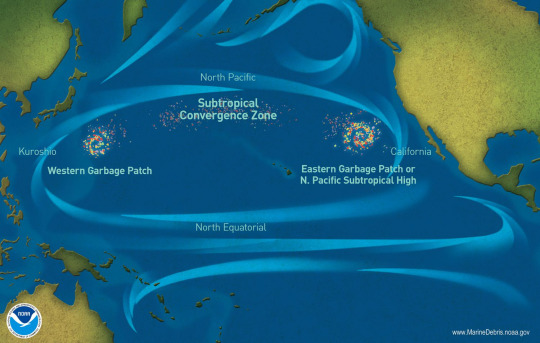
“Garbage Patch” – adalah julukan yang mungkin tidak tepat dan juga berlebihan untuk diberikan ke wilayah laut terbuka seperti Samudra Pasifik di mana sampah laut memanglah terkonsentrasi dengan level tertinggi dibanding Samudra lainnya. Apalah arti sebuah nama? - Nama "Garbage Patch " mungkin sedikit keliru jika dilihat dari faktanya. Di sana tidak ada pulau sampah yang terbentuk di tengah lautan atau selimut sampah yang dapat dilihat dengan satelit atau foto udara. Ini adalah kemungkinan besar karena sebagian besar puing yang ditemukan di sini adalah serpihan kecil yang mengambang plastik tidak mudah terlihat dari perahu.
Eastern garbage patch ini merupakan konsentrasi puing-puing laut yang telah tercatat di daerah tengah antara Hawai'i dan California yang dikenal sebagai North Pacific Subtropical High atau singkatnya “The High”. “The High” bukanlah bidang yang diam, melainkan bidang yang berputar, bergerak, dan berubah tempat. Western garbage patch – adalah area lain dari konsentrasi sampah laut terletak di lepas pantai Jepang, dan para peneliti percaya itu sebagai pilin resirkulasi kecil (fitur laut terdiri dari arus yang spiral sekitar titik pusat) kemungkinan diciptakan oleh angin dan pusaran laut.

The Great Pacific Garbage Patch adalah kumpulan sampah laut di Samudra Pasifik Utara. Sampah laut adalah sampah yang berakhir di lautan, laut, dan badan air besar lainnya.The Great Pacific Garbage Patch, juga dikenal sebagai pusaran sampah Pasifik, membentang di perairan dari Pantai Barat Amerika Utara hingga Jepang. Garbage Patch itu sebenarnya terdiri dari Western Garbage Patch, yang terletak di dekat Jepang, dan Garbage Patch, yang terletak di antara negara bagian Hawaii dan California di AS.
Area puing-puing yang berputar ini dihubungkan bersama oleh Zona Konvergensi Subtropis Pasifik Utara, yang terletak beberapa ratus kilometer di utara Hawaii. Zona konvergensi ini adalah tempat air hangat dari Pasifik Selatan bertemu dengan air dingin dari Kutub Utara. Zona ini bertindak seperti jalan raya yang memindahkan puing-puing dari satu petak ke petak lainnya.
Seluruh Garbage Patch Pasifik Besar dibatasi oleh Pusaran Subtropis Pasifik Utara. Administrasi Kelautan dan Atmosfer Nasional (NOAA) mendefinisikan pilin sebagai sistem besar arus laut yang berputar-putar. Namun, semakin mengacu pada Garbage Patch/ pusaran sampah plastik dan puing-puing yang dipecah menjadi partikel kecil di lautan. Pusaran Subtropis Pasifik Utara dibentuk oleh empat arus yang berputar searah jarum jam di sekitar area seluas 20 juta kilometer persegi (7,7 juta mil persegi): arus California, arus Khatulistiwa Utara, Arus Kuroshio, dan arus Pasifik Utara.
Area di tengah gyre cenderung sangat tenang dan stabil. Gyre adalah sistem besar arus laut yang berputar-putar. Area di tengah gyre cenderung sangat tenang dan stabil. Gerakan melingkar pilin menarik puing-puing ke pusat stabil ini, di mana ia menjadi terperangkap. Botol air plastik yang dibuang di lepas pantai California, misalnya, membawa Arus California ke selatan menuju Meksiko. Di sana, ia mungkin menangkap Arus Khatulistiwa Utara, yang melintasi Pasifik yang luas. Di dekat pantai Jepang, botol itu dapat bergerak ke utara melalui Arus Kuroshio yang kuat. Akhirnya, botol bergerak ke timur di Arus Pasifik Utara. Pusaran lembut dari Eastern Garbage Patch dan Western Garbage Patch secara bertahap menarik botol.
Jumlah puing-puing di Great Pacific Garbage Patch terakumulasi karena sebagian besar tidak dapat terurai secara hayati. Banyak plastik, misalnya, tidak aus; mereka hanya pecah menjadi potongan-potongan yang lebih kecil dan lebih kecil. Bagi banyak orang, ide tempat sampah memunculkan gambaran pulau sampah yang mengambang di lautan. Pada kenyataannya, Garbage Patch ini hampir seluruhnya terdiri dari potongan-potongan kecil plastik, yang disebut mikroplastik. Mikroplastik tidak selalu dapat dilihat dengan mata telanjang. Bahkan citra satelit tidak menunjukkan sepetak sampah raksasa. Mikroplastik dari Great Pacific Garbage Patch dapat membuat air terlihat seperti sup yang keruh. Sup ini dicampur dengan barang-barang yang lebih besar, seperti peralatan memancing dan sepatu.

Dasar laut di bawah Great Pacific Garbage Patch mungkin juga merupakan tumpukan sampah bawah air. Ahli kelautan dan ekologi baru-baru ini menemukan bahwa sekitar 70 persen sampah laut benar-benar tenggelam ke dasar lautan. Sementara ahli kelautan dan klimatologi memperkirakan keberadaan Great Pacific Garbage Patch, kapten kapal balap bernama Charles Moore yang benar-benar menemukan pusaran sampah. Moore sedang berlayar dari Hawaii ke California setelah berkompetisi dalam perlombaan yachting. Saat melintasi Pusaran Subtropis Pasifik Utara, Moore dan krunya melihat jutaan keping plastik mengelilingi kapalnya.
Tidak ada yang tahu berapa banyak puing-puing yang membentuk Great Pacific Garbage Patch. Pusaran Subtropis Pasifik Utara terlalu besar untuk dijelajahi oleh para ilmuwan. Selain itu, tidak semua sampah mengapung di permukaan. Puing-puing yang lebih padat dapat tenggelam beberapa sentimeter atau bahkan beberapa meter di bawah permukaan, membuat area pusaran hampir tidak mungkin diukur.
80 persen plastik di lautan diperkirakan berasal dari sumber berbasis darat, dengan 20 persen sisanya berasal dari kapal dan sumber laut lainnya. Persentase ini bervariasi menurut wilayah, namun. Sebuah studi tahun 2018 menemukan bahwa jaring ikan sintetis membentuk hampir setengah massa Great Pacific Garbage Patch, sebagian besar disebabkan oleh dinamika arus laut dan peningkatan aktivitas penangkapan ikan di Samudra Pasifik. Arus laut dan meningkatnya aktivitas penangkapan ikan ini menjadi dua penyebab utama penumpukan plastik di laut.
Sementara banyak jenis sampah yang berbeda masuk ke laut, plastik merupakan mayoritas sampah laut karena dua alasan. Pertama, daya tahan, biaya rendah, dan kelenturan plastik berarti plastik digunakan di semakin banyak produk konsumen dan industri. Kedua, barang-barang plastik tidak terurai tetapi malah terurai menjadi potongan-potongan yang lebih kecil.
Di lautan, matahari memecah plastik ini menjadi potongan-potongan yang lebih kecil dan lebih kecil, sebuah proses yang dikenal sebagai fotodegradasi. Sebagian besar sampah ini berasal dari kantong plastik, tutup botol, botol plastik air minum, dan gelas styrofoam. Sampah laut bisa sangat berbahaya bagi kehidupan laut di pilin. Misalnya, penyu tempayan sering salah mengira kantong plastik sebagai jeli, makanan favorit mereka. Albatros salah mengira pelet resin plastik sebagai telur ikan dan memberinya makan untuk anak ayam, yang mati karena kelaparan atau organnya pecah.
Anjing laut dan mamalia laut lainnya sangat berisiko. Mereka dapat terjerat dalam jaring ikan plastik yang ditinggalkan, yang sebagian besar dibuang karena cuaca buruk dan penangkapan ikan ilegal. Anjing laut dan mamalia lain sering tenggelam dalam jaring yang terlupakan ini—fenomena yang dikenal sebagai “pemancingan hantu”.Sampah laut juga dapat mengganggu jaring makanan laut di Pusaran Subtropis Pasifik Utara. Saat mikroplastik dan sampah lainnya terkumpul di atau dekat permukaan laut, mereka menghalangi sinar matahari mencapai plankton dan ganggang di bawahnya.
Alga dan plankton adalah autotrof yang paling umum, atau produsen, dalam jaring makanan laut. Autotrof adalah organisme yang dapat menghasilkan nutrisi sendiri dari karbon dan sinar matahari.Jika komunitas alga dan plankton terancam, seluruh jaring makanan dapat berubah. Hewan yang memakan alga dan plankton, seperti ikan dan kura-kura, akan memiliki lebih sedikit makanan. Jika populasi hewan-hewan tersebut berkurang, maka akan semakin sedikit pula makanan bagi predator puncak seperti tuna, hiu, dan paus. Akhirnya, makanan laut menjadi kurang tersedia dan lebih mahal bagi orang-orang.
Bahaya ini diperparah oleh fakta bahwa plastik melarutkan dan menyerap polutan berbahaya. Saat plastik terurai melalui fotodegradasi, mereka melepaskan pewarna dan bahan kimia, seperti bisphenol A (BPA), yang telah dikaitkan dengan masalah lingkungan dan kesehatan. Sebaliknya, plastik juga dapat menyerap polutan, seperti PCB, dari air laut. Bahan kimia ini kemudian dapat memasuki rantai makanan ketika dikonsumsi oleh kehidupan laut.
Karena Great Pacific Garbage Patch begitu jauh dari garis pantai negara mana pun, tidak ada negara yang akan bertanggung jawab atau menyediakan dana untuk membersihkannya. Charles Moore, orang yang menemukan pusaran itu, mengatakan membersihkan tempat sampah akan "membangkrutkan negara mana pun" yang mencobanya. Banyak individu dan organisasi internasional, bagaimanapun, berdedikasi untuk mencegah patch tumbuh.
Membersihkan sampah laut tidak semudah kedengarannya. Banyak mikroplastik berukuran sama dengan hewan laut kecil, jadi jaring yang dirancang untuk mengambil sampah akan menangkap makhluk ini juga. Bahkan jika kita dapat merancang jaring yang hanya akan menangkap sampah, ukuran lautan membuat pekerjaan ini terlalu memakan waktu untuk dipertimbangkan. Program Sampah Laut dari National Ocean and Atmospheric Administration memperkirakan bahwa dibutuhkan 67 kapal dalam satu tahun untuk membersihkan kurang dari satu persen Samudra Pasifik Utara.
Banyak ekspedisi telah melakukan perjalanan melalui Great Pacific Garbage Patch. Charles Moore, yang menemukan patch pada tahun 1997, terus meningkatkan kesadaran melalui organisasi lingkungannya sendiri, Algalita Marine Research Foundation. Selama ekspedisi 2014, Moore dan timnya menggunakan drone udara, untuk menilai dari atas sejauh mana sampah di bawah. Drone menentukan bahwa ada 100 kali lebih banyak plastik berdasarkan berat daripada yang diukur sebelumnya. Tim juga menemukan fitur plastik yang lebih permanen, atau pulau, beberapa di antaranya lebih dari 15 meter (50 kaki) panjangnya.
Semua plastik terapung di Great Pacific Garbage Patch menginspirasi Tim National Geographic Emerging Explorer (dikutip dari National Geographic Socierty), David de Rothschild dan timnya di Adventure Ecology untuk membuat kapal layar yang terbuat dari dua perangkat flotasi besar dan bingkai di atasnya, yang terbuat dari botol plastik dengan nama Plastiki. Kapal layar yang sebagian terbuat dari botol air plastik yang digunakan untuk melakukan perjalanan dari San Francisco, California, ke Sydney, Australia. Kekokohan Plastiki menunjukkan kekuatan dan daya tahan plastik, cara kreatif untuk menggunakannya kembali, dan ancaman yang ditimbulkannya terhadap lingkungan jika tidak terurai. Pada 2010, tim dari National Geographic Emerging Explorer berhasil menavigasi dari San Francisco, California, ke Sydney, Australia.
Para ilmuwan dan penjelajah sepakat bahwa membatasi atau menghilangkan penggunaan plastik sekali pakai dan meningkatkan penggunaan sumber daya yang dapat terurai secara hayati akan menjadi cara terbaik untuk membersihkan Great Pacific Garbage Patch. Organisasi seperti Plastic Pollution Coalition dan Plastic Oceans Foundation menggunakan media sosial dan kampanye aksi langsung untuk mendukung individu, produsen, dan bisnis dalam transisi mereka dari plastik beracun dan sekali pakai ke bahan yang dapat terurai secara hayati atau dapat digunakan kembali.

Jadi apa yang dapat dilakukan sebagai individu untuk mengurangi hal seperti ini? Satu jawabannya adalah tanggung jawab antar individu. Bertanggung jawab atas semua sampah Anda di darat dan di air. Buang barang-barang yang tidak dipakai dengan bijak di tempat seharusnya. Berpartisipasi dalam pembersihan lokal di daerah Anda dan ingatlah bahwa daratan dan laut, di mana pun Anda berada, terhubung. Mengurangi jumlah limbah yang dihasilkan,gunakan kembali barang jika memungkinkan. Pilih barang yang dapat digunakan kembali daripada yang sekali pakai.Dan terpenting daur ulang sebanyak mungkin. Tas, botol dan tutup, kaleng, ponsel, kartrid tinta, dan banyak barang lainnya dapat didaur ulang
1 note
·
View note
Text
Ocean Plastic Is Creating New Communities of Life on the High Seas
Ocean Plastic Is Creating New Communities of Life on the High Seas
Anika Albrecht of Ocean Voyages Institute, on a 2020 expedition collecting plastic in the North Pacific Subtropical Gyre, where she served as Chief Mate. (Photo courtesy of Ocean Voyages Institute 2020 Gyre Expedition)
Coastal Organisms Thrive on Floating Plastic Debris in the “Great Pacific Garbage Patch”
Coastal plants and animals have found a new way to survive in the open ocean—by…

View On WordPress
0 notes
Text
I’m sure you’ve all heard of the trash island in the ocean, but did you know there are two? They are connected by something called the “North Pacific Subtropical Gyre”, and the two islands are just called the Eastern and Western garbage patches, and it is not biodegradable.
0 notes
Text
Who Governs Climate Intervention and Geoengineering on the High Seas?
[By Olive Heffernan]
In late March, as most of the world was adjusting to lockdown, oceanographer Daniel Harrison was setting sail for the Great Barrier Reef. Though Harrison, a native Australian, had sailed these waters many times before, this particular expedition was different.
On reaching Broadhurst Reef, 100km off the Australian coast, Harrison and his skeleton crew of local scientists – just a few with permission to travel – noticed white corals stretching out in every direction, a sign that the reef was bleaching, and dying, from heat stress. This would be the third mass bleaching of the Great Barrier Reef in just five years, an event that is becoming more likely as the global ocean warms.
Harrison and his team were there to test a radical intervention that, if successful, could spare the world’s largest coral reef from total loss. Known as marine cloud brightening, their approach involves spraying seawater into the air to help form bright clouds that reflect sunlight and cool the waters below. “This is like putting the reef on life support while we deal with the underlying cause. It buys us some time” says Harrison. “Obviously bringing emissions down is the critical thing.”
Climate intervention
While Harrison’s project is small in scale, and in its infancy, marine cloud brightening is just one of numerous practices – collectively known as geoengineering or climate intervention – that could cool the planet, offsetting some of the harm caused by greenhouse gas pollution. With global emissions rising, there’s a growing awareness that we’ll likely need such radical measures to avoid dangerous climate change. “Emissions reductions alone are not going to cut it,” says Phillip Boyd, a marine biogeochemist at the University of Tasmania, Hobart. “We’ve got an increasingly fast-moving problem, and so we may need increasingly fast-moving countermeasures,” says Kelly Wanser, founder of US non-profit Silver Lining, which advocates for research into climate intervention.

A trial of prototype cloud-brightening equipment on the Great Barrier Reef (Image: Brendan Kelaher / Southern Cross University)
Using technology to control the climate is undeniably controversial, seen by some as a quick fix with unknown consequences that diverts attention from the harder task of transitioning to a zero-carbon economy. As such, there’s been little funding for research, and few real-world trials. Harrison’s project – focused on curbing a national ecological disaster – is a notable exception. “It’s essential to know whether these things work or not,” says Harrison. “If we find out that they don’t work, it just strengthens the argument for reducing emissions harder and quicker and not delaying”.
Geoengineering – or deliberate climate control – is not new. During the Cold War, both the US and the Soviet Union funded research into cloud seeding, an approach the US eventually used during the Vietnam war to extend the monsoon season and disrupt enemy troops. Since then, the field has expanded into a wide array of schemes mostly intended to mitigate climate change, though some have co-benefits such as boosting fisheries.
Broadly speaking, there are two approaches. The first, Solar Radiation Management (SRM), aims to limit the amount of heat absorbed by the Earth and could be used to quickly cool the surface. This could be achieved, for instance, by sending reflective sulphates into the stratosphere via giant balloons, or by scattering silica beads over Arctic sea ice to make it more reflective.
The alternative, Carbon Dioxide Removal (CDR), focuses on physically extracting CO2 from the atmosphere and storing it, in ecosystems such as mangroves or forests, underground or in the deep ocean. Possibilities here include fertilising the sea surface with iron to promote the growth of plankton – which absorb CO2 from the air – or burning biomass as a source of energy, capturing the CO2 and storing it.
In general, SRM is seen as the more extreme approach that could be deployed with quick results in the case of a regional or global climate emergency.
So far, no single scheme has been proven to work at scale. Most research has focused on land-based solutions, but competing needs, such as ensuring food security, makes these impractical as global solutions. Scientists are now looking to the open ocean as a more pragmatic choice for geoengineering. “This is where it makes most sense, because there’s no conflict of interest with any other issues. These areas are largely unused at the moment and they also make up 50% of the planet’s surface” says Ulf Riebesell, a biological oceanographer at the GEOMAR Helmholtz Centre for Ocean Research in Kiel, Germany.
So far, 27 different marine geoengineering schemes have been proposed. There has been roughly a dozen field tests, mostly focused on ocean iron fertilisation. When a commercial company, Planktos Inc, proposed to test the technology off the Galapagos Islands in 2007, it sparked fears of unregulated interference with the planet’s climate by entrepreneurs looking to turn a quick profit by selling sequestered CO2 as carbon credits.
In response, two intergovernmental bodies sought to outlaw geoengineering. In 2010, the UN’s Convention on Biological Diversity recommended that member states ban the deployment of all large-scale climate intervention technologies, a stance that it reaffirmed in 2016. Meanwhile, in 2013, the UN’s International Maritime Organization (IMO) – which regulates shipping – added ocean iron fertilisation to its list of banned practices. Though the IMO measure is voluntary and yet to be enforced, it symbolises the taboo long associated with climate intervention.
Growing expectations for unproven technologies
With global emissions still growing despite the commitments made in Paris in December 2015, the mood has started to shift. The Intergovernmental Panel on Climate Change has made it clear that we have little chance of avoiding dangerous levels of warming, generally regarded as 1.5C or 2C above pre-industrial temperatures, without geoengineering technologies. Meanwhile, high level organisations such as the UN Environment Programme and the US National Academies of Sciences have started to seriously evaluate options for climate intervention.
“We’re now in a situation where we’re implicitly assuming that we’ll need large-scale CO2 removal, but we really haven’t put the time and money into actually finding out whether we can do it or not”, says Jeffrey McGee, director of the Australian Forum for Climate Intervention Governance at the University of Tasmania, Hobart. “The gap between expectations and knowledge, I think, is getting wider and wider by the day.”
There’s not much time to decide which of these options is useful. We shouldn’t wait another year. The science needs to start now.
Globally, just a few marine geoengineering projects are ready for field trials. Ocean artUp, being led by Ulf Riebesell, is testing the idea that artificial ocean upwelling – using vertical pumps – can enrich the ocean’s nutrient-poor subtropical gyres, boosting fish production and CO2 uptake. Riebesell’s team is currently testing various pump designs in waters off the north Atlantic island of Gran Canaria.
Ice911, an initiative started by Leslie Ann-Field, a lecturer at Stanford University in California, aims to prove that it’s possible to use technology to restore Arctic ice. Field’s method involves scattering tiny glass silica beads on the surface of thin, young Arctic sea ice as a way of boosting its reflectivity by 50%. Field’s team was due to test the method on a small scale at Utqiagvik, Alaska this summer but plans have been scaled back owing to Covid. Follow-on plans to test the method in the Arctic at a larger scale will need additional funding.
Meanwhile, the Marine Cloud Brightening Research Program, a collaboration between the University of Washington, the Pacific Northwest National Laboratory, and a team of retired engineers in Silicon Valley, has emerged as the sole significant US effort in marine geoengineering. With limited funding, the team has designed a bespoke nozzle that can generate three trillion particles of tiny salt particles per second from filtered sea water. The next step, developing this into a system of 400-500 nozzles that can be tested in the field, will need roughly $4-5 million, which the research team is currently raising.

Prototype cloud brightening equipment (Image: Alejandro Tagliafico / SIMS and Southern Cross University)
The consequences of deploying any of these technologies at scale is unknown. Already, the ocean has soaked up one third of the roughly 40 billion tonnes of CO2 that we emit annually, as well as 93% of the extra heat from climate change. While this has tempered climate change on land, it has caused the ocean to warm rapidly and become more acidic. Conservationists worry that marine geoengineering could harm marine life, or the health of the ocean.
“Geoengineering is not only complex and unknown, but it has huge potential impact,” says Torsten Thiele, founder of the Global Ocean Trust, a non-profit that focuses on marine conservation, technology and governance. “I’m very sceptical on letting people try things out until we’ve sorted out the other steps and processes. Let’s first figure out the framework, let’s figure out the ethics standards, let’s figure out what happens in the lab. We could create a long list of things that would allow natural scientists to improve knowledge without actually trying these things out in nature.”
Governance gap
With field trials inching forward, attention is turning to how geoengineering research – and deployment, if it ever happens – should be governed. Right now, different laws could be applied to geoengineering on land and in the ocean, but none are comprehensive. The IMO amendment on ocean iron fertilisation, for instance, just applies to a single method and then only if the iron is “dumped” at sea, rather than piped or injected, for instance. “What we have right now is a patchwork of rules,” says Kerryn Brent, who researches international environmental law at the University of Adelaide, Australia.
One possibility for governing marine geoengineering is through a new law to protect marine life on the high seas, those waters that are beyond national governance. The law, which is currently being negotiated by the UN, will likely require any activity that takes place on the open ocean to first undertake an environmental impact assessment, a formal process to gauge potential damage to marine life.
While this would limit the possibility of harmful experimentation in the open ocean, some feel there is a need for more structured, high level governance of geoengineering. The problem right now, says Brent, is that no single organisation or body has a mandate to gauge the risk of harm caused by geoengineering against the risk of inaction. “One of the big gaps in governance are rules that will enable decision-makers, countries and scientists to weigh up the risks of a specific research activity or deployment versus the risk of not doing it. We just don’t have those kind of rules available," she says.
“Part of the point of all the testing and modelling that we do is to establish the safety, the efficacy and the risks” says Leslie-Ann Field, founder of Ice911. “Our first principle is to do no harm, right? But there’s also just this vast risk of doing nothing,” she says.
According to non-profit Silver Lining, the UNFCCC, which oversees international climate policy talks, could have a role in evaluating both the merits and risks of geoengineering research. The question still remains as to whether one entity, and which, would have the authority to sanction or prevent the deployment of climate intervention. The UN Security Council is one possibility, though with 15 member states, only five of which are permanent, gaining global consensus could be difficult. Meanwhile, scientists say they need regulations urgently for field research to forge ahead. “We need to phase in these technologies in ten years from now. We already know that,” says Riebesell. "That’s not much time to decide which of these options is useful. We shouldn’t wait another year. The science needs to start now.”
Olive Heffernan is a freelance science journalist who covers oceans and climate change. You can tweet her at @O_Heffernan and read her latest stories at www.oliveheffernan.com.
from Storage Containers https://www.maritime-executive.com/article/who-governs-climate-intervention-and-geoengineering-on-the-high-seas
via http://www.rssmix.com/
1 note
·
View note
Video
youtube
The Monumental Effort To Rid The World's Oceans From Plastic
Plastic in the world's oceans is reaching epidemic proportions -- it's estimated that by 2050 there will be more plastic in the ocean than fish. The world dumps the equivalent of one garbage truck of plastic into the ocean every minute, or eight million tonnes of plastic every year. Beyond ruining beaches and harming marine life, this plastic is becoming a permanent part of food chains and ecosystems by breaking down into dangerous microplastics, or tiny particles that absorb chemicals in their environment. These microplastics have made their way across the globe and into ecosystems as remote as the Arctic sea ice.
In 2008, VICE documented the scope of the Great Pacific Garbage Patch, a subtropical gyre where marine debris concentrates due to the ocean's currents. Eight years later, VICE followed up on the problem, visiting one of the most polluted beaches in the world, Kamilo Point in Hawaii, and exploring how that plastic is finding its way into our food chain.
Though the sheer magnitude of waste in our oceans makes the problem seem impossible to fix, one young Dutch engineer claims he has the solution. This year, Boyan Slat and his Ocean Cleanup team plan to deploy a structure in the Pacific with the aim to clean up half the Great Pacific Garbage Patch’s plastic in just 5 years, all while converting millions of pounds of collected plastic into reusable products. VICE traveled to the North Sea to see the deployment of Slat's prototype and discuss the feasibility of saving our world’s oceans. .
1 note
·
View note
Text
Marine Biology Story of the Day #8
Before I start in on this one I would just like to say how all of your reblogs and likes totally make my day—thanks so much for the support! I put a lot of effort into these so they read well!
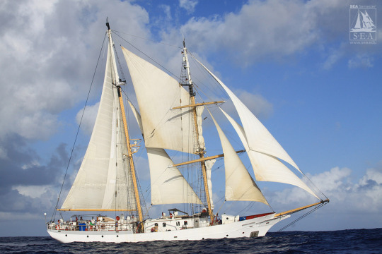
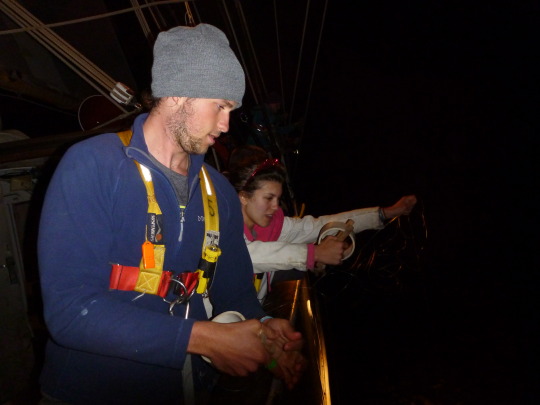
Okay, so as promised, this is part 2 of what it’s like to live on a working tallship. You can check out part 1 and other information about this voyage here: post 7 and post 1 . Today we are going to talk about what it’s like to do science on a sailing vessel. Our baby was the Robert C. Seamans, a 134 ft brigantine.
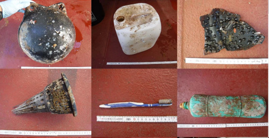
We were limited to what we could research-wise do since a sailing vessel does not have the same power as a modern vessel with an engine. We were mainly researching plastic concentration (from trash and garbage that gets released into the ocean) in the north pacific subtropical gyre. A gyre is basically a big ocean current, and they tend to concentrate plastic and garbage into central regions (shown below) we were studying the garbage patch off the California coast.
We did see a lot of large plastic, mostly in the form of in-tact plastic containers, buoys, or derelict fishing gear (known as ghost fishing, because this gear continues to catch and kill fish even though no one is benefiting from it).

But, in actuality, most of the plastic found in these patches is nano or micro, basically little pieces that have broken off of larger pieces and get worn down by the wind and the waves. This also includes little pieces of fishing line (monofilament). These pieces are often more dangerous because very small organisms (including plankton!) can swallow them, and the plastic can rip up their insides and release harmful chemicals.

How did we sample for this micro plastic? The same way we did plankton! We used a net with very very fine mesh called a neuston net, which we towed along side the ship, and then we filtered the water into increasingly smaller sizes of mesh. After that, used a microscope to sort and count plastic, and to identify species within the plankton community.

We caught a lot of interesting organisms and species in these tows, including these types of zooplankton below:
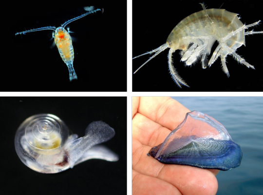
Top row: Copepods and amphipods, which sort of form the bottom of the food chain out in the open ocean, Bottom left: pteropod, or a swimming snail, these guys have modified their “feet” to form wings that the flap to get around in the open ocean, Bottom right: velella velella, or by-the-wind sailors, are siphonophores (similar to jellyfish) that use their big sail to push them around the surface of the ocean.
We also caught a variety of larger organisms, including flying fish (which are a real treat to see IRL, they really do glide for hundreds of feet) and various species of squid.

We also collected water samples. Water temperature, salinity, and dissolved oxygen are all important parameters that help us understand why certain species live where, and how climate change could impact these species habitats and ranges. We used a hydrocast (shown below) to do this:

A hydrocast has multiple canisters that are all opened before the hydrocast is lowered down, and each cannister is programmed to snap shut at a different depth. This way we could collect water samples at a variety of different depths, all the way down to the sea floor.
We also sampled at night to collect deep sea plankton and fishes as they migrated up to the surface to feed (called diel vertical migration). During the nighttime, there are less predators, so it’s more beneficial for them to come up to the surface and access the nutrients and phytoplankton on the surface. If you want to check out some of these deep sea critters, check out my previous post! In the meantime though, to pass time, we would sometimes fish for squid. This involved shining a light down in the water to attract the squid, and then throw baited handlines down in the water—we were not often successful.
We were more successful at fishing for tuna and mahi mahi however, during the daytime. We would throw a baited line off the back of the ship while the ship was running at full sail. These fish would get fin clips for genetic studies, and would also get turned into some pretty boss cerviche, poke, and fish tacos (our stewards, or boat chefs, were AMAZING). Don’t worry, we didn’t catch too many of these guys, but they were still pretty cool to see up close and in person.

Left, A mahi mahi, (or dolphinfish or dorodo, depending on where you come from) slowly loosing color; these fish die pretty quickly out of water, and they quickly become grey, loosing their bright blue and yellow coloration. Right, a skipjack tuna; these are one of the smallest tuna species and are usually considered trash fish—the endangered bluefin and yellowfin tuna are like, bigger than a person. It will blow your mind.
One last thing before we go—by the end of the trip they started letting us, the students become the chief scientist during our watches, which was an amazing learning experience, and we were bestowed the magical tutu of chief scientist-dom (made out of a torn neuston net).
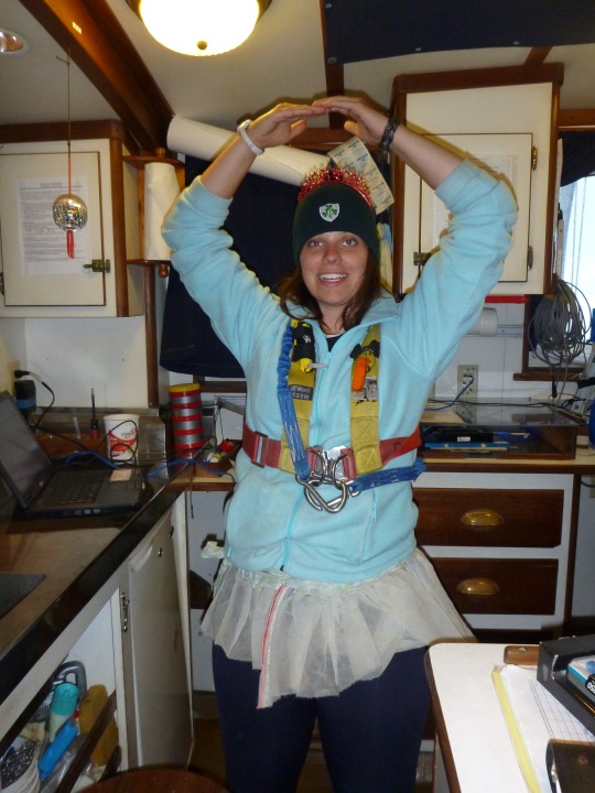
This picture of me was taken in the science lab when we officially hit 1000 nautical miles into our journey—at 3 am in the morning. Yes, being a scientist was a 24 hour job on this trip, if you couldn’t tell from my dark circles.
Alright, well that’s about all I have for today. Next week I’ll reveal to you all what I do as a marine biologist currently, and while I’m no longer sailing on the pacific, I’m still doing big studies---and this time, they are all
And as always, PLEASE don’t hesitate to ask about this research or anything else on this trip!
#marine biology#marine biologist#marine biologist story of the day#ocean science#ocean stories#tall ships#robert c seamans#seasemester#plankton#zooplankton#copepod#amphipod#pteropod#velella#flying fish#mahi mahi#dolphinfish#dorado#tuna#skipjack tuna#marine biology story of the day#plastic ocean#ghost fishing
12 notes
·
View notes
Photo

Great Pacific Garbage Patch 2.4.20
One might ask what the Great Pacific garbage patch is. Well it is defined as a collection of marine debris in the North Pacific Ocean. Also known as the Pacific trash vortex, the garbage patch is actually two distinct collections of debris bounded by the massive North Pacific Subtropical Gyre. (National Geo). The entire garbage patch is bounded by the North Pacific subtropical gyre. A gyre is a vortex. The oceans natural current is trapping millions of tonnes of plastic there. The GPGP isn’t the only one, there are about 5 patches worldwide, but this one is the biggest. Much of the waste that is captured there is not biodegradable. According to National Geographic, “About 54 percent of the debris in the Great Pacific Garbage Patch comes from land-based activities in North America and Asia. The remaining 20 percent of debris in the Great Pacific Garbage Patch comes from boaters, offshore oil rigs, and large cargo ships that dump or lose debris directly into the water. The majority of this debris—about 705,000 tons—is fishing nets. More unusual items, such as computer monitors and LEGOs, come from dropped shipping containers.” The reason why this is so detrimental to marine health is because the sun breaks the plastics down into small pieces called microplastics. Microplastics will then be consumed by marine life which could ultimately kill them. Not only does consumption kill the marine life, the plastic also blocks sunlight from reaching algae and plankton. The plastics in the GPGP also leak harmful toxins into the surrounding environment. Because the location is thousands of miles off of any shore, no nation will take responsibility to provide the cleanup that is desperately necessary. National geographic states, “cleaning up the garbage patch would “bankrupt any country” that tried it.” Because of all the setbacks the garbage patches receive, nothing is currently being done to make a significant impact on the GPGP clean up. The GPGP is about, “The GPGP covers an estimated surface area of 1.6 million square kilometers, an area twice the size of Texas or three times the size of France” (The Ocean Clean-Up). The Ocean Clean-Up also points out that there are, “A total of 1.8 trillion plastic pieces were estimated to be floating in the patch – a plastic count that is equivalent to 250 pieces of debris for every human in the world.”

Because plastic takes centuries to biodegrade, many of the plastics found in the Great Pacific garbage patch are from years ago, like this crate for example. Because many Humans eat fish, we are also affected by the plastics in the ocean gyres. The Ocean Clean-Up clarifies, “Through a process called bioaccumulation, chemicals in plastics will enter the body of the animal feeding on the plastic, and as the feeder becomes prey, the chemicals will pass to the predator – making their way up the food web that includes humans. These chemicals that affected the plastic feeders could then be present within the human as well. Decreasing plastic waste will help the Ocean gyres, but it won’t take the plastic out that is already there. A clean up is necessary, not only for marine life, but for Human health as well.
Sources:
https://www.nationalgeographic.org/encyclopedia/great-pacific-garbage-patch/
https://theoceancleanup.com/great-pacific-garbage-patch/
0 notes
Last Seen Blogs

she-ranger
I Do Not Fear Death

domtopgirl5
DOMTOPGIRL

eins-vier
A Dish Best Served Coldly

meapremati
Untitled

lisuby
Grace