#raremap
Photo
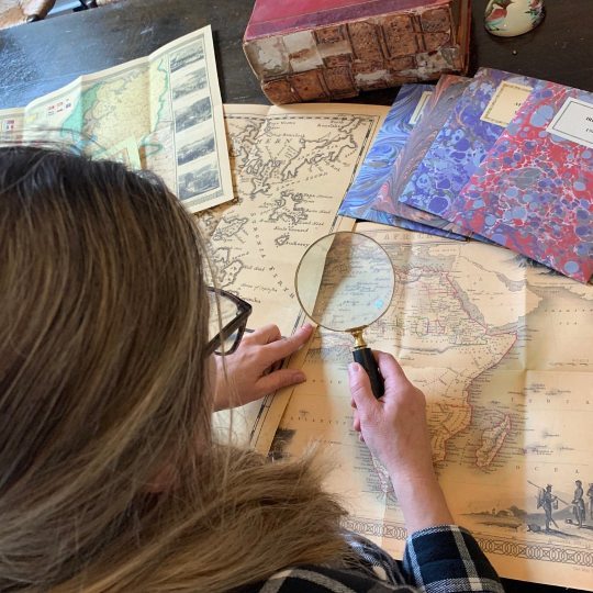
Hello Map lovers! ⠀⠀⠀⠀⠀⠀⠀⠀⠀ Nowadays, when satellite images and GPS Services offer incredibly accurate images of the Earth's surface, we can easily forget that most human history has been an unknown tabula rasa on which Cartographers, scientists, men of faith, and sovereigns have imprinted their dreams and drawn their ideas. ⠀⠀⠀⠀⠀⠀⠀⠀⠀ Ancient maps are where we can see the birth of the modern world through the eyes of the historian. It is undeniable that offer us adventure, lessons in politics, history, and philosophy, and a panorama of artistic creativity unsurpassed in sheer beauty of form. ⠀⠀⠀⠀⠀⠀⠀⠀⠀ So, as Kevin J. Brown wrote in his book, A Journey Back in Time Through Maps, "Ancient maps are a touching reminder that our knowledge and our perception of the world are abundant and limited at the same time.” ⠀⠀⠀⠀⠀⠀⠀⠀⠀ ⏳Old Maps Library specialises in the reprint of Vintage Maps and Illustrations between the 17th to 19th centuries. ⠀⠀⠀⠀⠀⠀⠀⠀⠀ ⏳ We have a beautiful collection of Old Maps and Vintage Illustrations on our website. Link on our bio. . . . . . . . . #oldmap #vintagemap #raremap #cartographer #antiquemap #ancientmap #gallerywalldecor #mapas #instamap (at London, Unιted Kingdom) https://www.instagram.com/p/ChIBqYKIkZa/?igshid=NGJjMDIxMWI=
0 notes
Photo
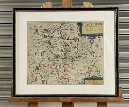
Rare Christopher Saxton / William Kip Map of Huntingdonshire Circa 1650 #christophersaxton #saxtonmap #williamkip #huntingdon #huntingdonshire #huntingdonmap #huntingdonshiremap #maps #raremap #17thcentury #17thcenturymap #oldmaps (at Huntingdon) https://www.instagram.com/p/CdINCiIoJUf/?igshid=NGJjMDIxMWI=
#christophersaxton#saxtonmap#williamkip#huntingdon#huntingdonshire#huntingdonmap#huntingdonshiremap#maps#raremap#17thcentury#17thcenturymap#oldmaps
0 notes
Text
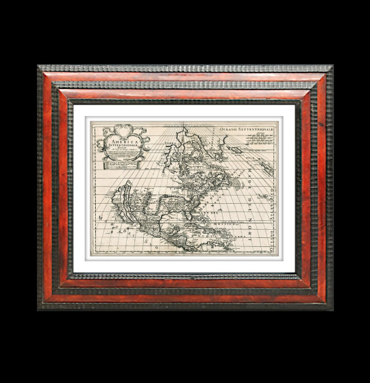
For Sale 🔥 Rare Old Map 1700, America Settentrionale, California As An Island.
https://www.busaccagallery.com/catalog.php?itemid=6439#
🔥 See some of the important maps from the early history of cartography at 🔥 Busacca Gallery.
#Cartography #AntiqueCartography #OldMaps #Maps #AntiqueMaps #RareMaps #AncientMaps #America #California #OldMap #CaliforniaMap #OldCalifornia #MapCollector #MapCollections #MapGallery #BusaccaGallery #ArtMap #MapPrint #MackDesign #InteriorDesign #FramedArt #FramedMap #HomeDecor #OfficeDecor #Luxury #LuxuryDesign
0 notes
Photo

Spencer's pick is a remarkable discovery: a scarce 1864 book on #Gettysburg, with ms. notes describing the battle, and two tipped-in maps: one an unrecorded printed map by Andrew J. Cross, another a manuscript map of the battle dated to 1863! #geographicus #li #antiquemaps #civilwar #battleofgettysburg #americancivilwar #raremap #antiquemap Http://bit.ly/geographicus (at Geographicus Rare Antique Maps) https://www.instagram.com/p/B3w9cQyptKD/?igshid=1vn0g2dno5koc
#gettysburg#geographicus#li#antiquemaps#civilwar#battleofgettysburg#americancivilwar#raremap#antiquemap
5 notes
·
View notes
Photo
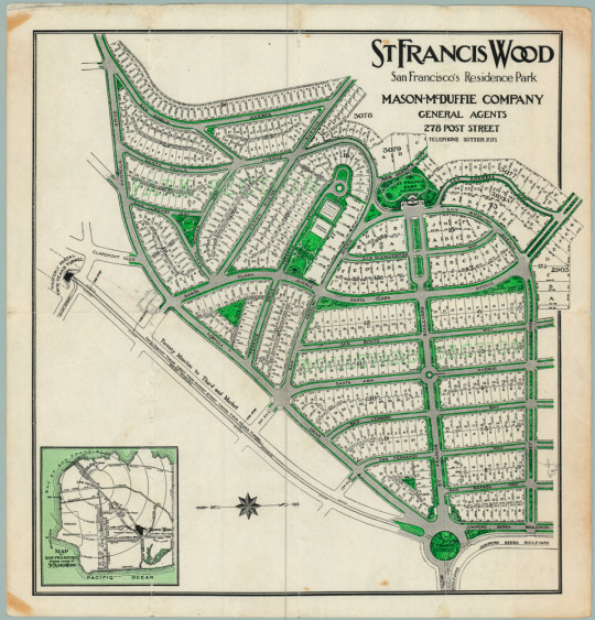
A rare circa 1912 cadastral plan of the nascent San Francisco neighborhood of St. Francis Wood. #SanFrancisco #raremaps,://t.co/hsUO1B7LTr
by @NeatlineMaps
92 notes
·
View notes
Photo
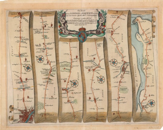
Ogilby, John, 1600-1676. The road from London to Harwich in Essex. London : Printed by the author?, approximately 1675
G5753.E7P2 1675 .O3 Voorhees collection
#map#roadmap#england#17thcentury#1670s#johnogilby#london#harwich#essex#compass#compassrose#cartouche#royalcrest#cartography#mapmonday#beautifulmaps#oldmaps#raremaps#specialcollections#libraryofva
27 notes
·
View notes
Photo
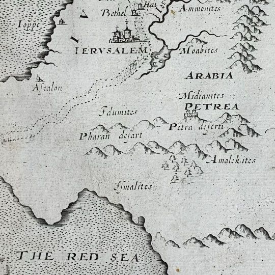
The History of the World by Sir Walter Raleigh. Fourth edition from 1628, complete with 8 fold-out maps. Petra has been on my mind lately (@bedouin_official just did a set for @cerclemusic at Al-Khazneh, for anyone interested), so here are three maps that all feature that ancient Jordanian city. The History of the World is an ambitious work that surveys the beginning of civilization to 146 BC, dealing primarily with biblical, Greek, and Roman history. Raleigh wrote the book while imprisoned in the Tower of London, completing it with the aid of assistants and the Tower’s library, which included more than 500 books. #petra #petrajordan #sirwalterraleigh #historyoftheworld #rarebooks #raremaps #neareast (at B & B Rare Books, Ltd.) https://www.instagram.com/p/CcbBQnDJicP/?igshid=NGJjMDIxMWI=
1 note
·
View note
Photo

#Repost @mutineer_bay ・・・ #Repost @libertalia_a_pirate_story ・・・ #reading #leggere #historylovers #storia #artlife🎨 #pirates #cartography #cartografia #geography #antiquemaps #mapofthesoul #raremaps #archeology #exploration #explorers #globe_portraits #medievaltimes #piratelife #plunderdesign #conquer #rumlife #hoistthecolors #oceanlifestyle #pirateria #arthousecinema #blackbeard #blackflag https://www.instagram.com/p/CGqSgPpDwoI/?igshid=1kph8348xzbld
#repost#reading#leggere#historylovers#storia#artlife🎨#pirates#cartography#cartografia#geography#antiquemaps#mapofthesoul#raremaps#archeology#exploration#explorers#globe_portraits#medievaltimes#piratelife#plunderdesign#conquer#rumlife#hoistthecolors#oceanlifestyle#pirateria#arthousecinema#blackbeard#blackflag
0 notes
Photo
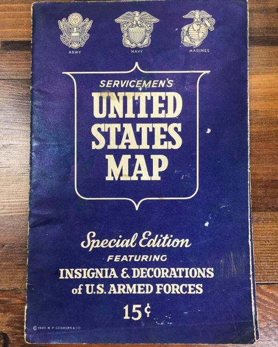
Serviceman’s US map, insignia & decorations of the armed forces Bid Now! Order on eBay or pick them up in person. Give us a call and we can put something on hold for you! (419)692-1888 located at 238 N Main St Delphos OH 45833 or click the link in our bio to find us on eBay ❤️ www.eBay.com/usr/CoinsCollectibles . . . . . . #paper #foodie #prints #map #oddities #fairfield #nature #interiordesign #luxurydesign #foodporn #ct #vintagemaps #fashion #photooftheday #raremaps #artist #trumbull #print #california #summer #vintage #london #mapping #mapmaking #antiquemap #design #art #norwalk #stamfordct #antiqueprints via @hashtagexpert (at Coins Currency and Collectibles) https://www.instagram.com/p/By0E5Vclg_6/?igshid=4l0pcnexs62k
#paper#foodie#prints#map#oddities#fairfield#nature#interiordesign#luxurydesign#foodporn#ct#vintagemaps#fashion#photooftheday#raremaps#artist#trumbull#print#california#summer#vintage#london#mapping#mapmaking#antiquemap#design#art#norwalk#stamfordct#antiqueprints
0 notes
Photo
Happy Wednesday!
⠀⠀⠀⠀⠀⠀⠀⠀⠀
Shall we take another journey back in time through an old map?
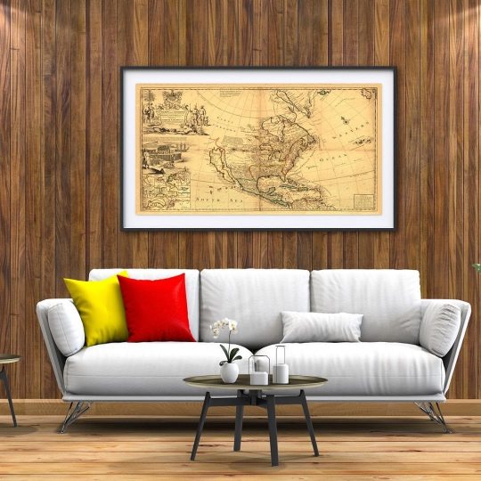
We have today this beautiful reproduction map of North America by Herman Moll, circa 1719.
⠀⠀⠀⠀⠀⠀⠀⠀⠀
One of Herman Moll’s most famous maps often referred to as The Codfish Map.
⠀⠀⠀⠀⠀⠀⠀⠀⠀
As an enhancement to his “Map of North America,” Moll engraved orthographic or plan views of ten bays in North America and the Caribbean in the lower left-hand corner of the map. ⠀⠀⠀⠀⠀⠀⠀⠀⠀
Each bay was the location of a major port city and harbour. ⠀⠀⠀⠀⠀⠀⠀⠀⠀
Five of the port cities were British (St. John’s, Boston, New York, Charleston, and Port Royal) and five were Spanish (Havana, Portobello, Vera Cruz, Cartagena, and Acapulco). ⠀⠀⠀⠀⠀⠀⠀⠀⠀
Moll engraved the insets in the style of navigational charts complete with numbers on some of the charts representing depth soundings in fathoms.
⠀⠀⠀⠀⠀⠀⠀⠀⠀
Herman Moll (1654?-1732) was a London cartographer, engraver, and publisher. ⠀⠀⠀
⠀⠀⠀⠀⠀⠀⠀⠀⠀
Visit our online shop for more old maps & Vintage Illustrations.
⠀⠀⠀⠀⠀⠀⠀⠀⠀
Link in Bio
.
.⠀⠀⠀⠀⠀⠀
.
#oldmap #vintagemap #raremap #northamericamap #mapofnorthamerica #cartographer #antiquemap #ancientmap #gallerywalldecor #mapas #instamap #mapdecor #mapsarecool #mapsofinstagram #mapsandillustrations #homedecorationideas #maplove #lovemaps #mapshop #mapsoftheworld #oldword #antiquemapsandprints #framedmaps #map #mapart #wallframe #mapprints #mappe #oldmapslibrary #mapasantiguos (at London, Unιted Kingdom)
https://www.instagram.com/p/CLcDgt5pmNZ/?igshid=q84prq89pwf4
#oldmap#vintagemap#raremap#northamericamap#mapofnorthamerica#cartographer#antiquemap#ancientmap#gallerywalldecor#mapas#instamap#mapdecor#mapsarecool#mapsofinstagram#mapsandillustrations#homedecorationideas#maplove#lovemaps#mapshop#mapsoftheworld#oldword#antiquemapsandprints#framedmaps#map#mapart#wallframe#mapprints#mappe#oldmapslibrary#mapasantiguos
1 note
·
View note
Photo
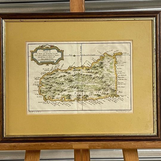
An extremely attractive example of Jacques-Nicolas Bellin’s 1758 map of Saint Lucia (St. Lucia) or Sainte Lucie in the West Indies. St. Lucia is considered among the most beautiful of the Windward Isles. This map covers this spectacular Caribbean island in considerable detail showing mountains, cities, and forests in Bellin’s distinctive profile style. Good harbors are marked with miniature anchors. A decorative rococo style title cartouche appears in the upper left quadrant. eBay item number 234889214538 #stlucia #bellinmap #stlucie #stluciamap #oldmap #map #cartography #maps #vintagemap #oldmaps #antiquemaps #vintage #vintagemaps #antiquemap #raremaps #history #thcentury #geography #antique #antiquemapsandprints #mapart #art #raremap #travel #alteagallery #worldmap #mapcollecting #mapmaker #antiques #oldmapsandprints https://www.instagram.com/p/CoYNt0EISeM/?igshid=NGJjMDIxMWI=
#stlucia#bellinmap#stlucie#stluciamap#oldmap#map#cartography#maps#vintagemap#oldmaps#antiquemaps#vintage#vintagemaps#antiquemap#raremaps#history#thcentury#geography#antique#antiquemapsandprints#mapart#art#raremap#travel#alteagallery#worldmap#mapcollecting#mapmaker#antiques#oldmapsandprints
0 notes
Photo
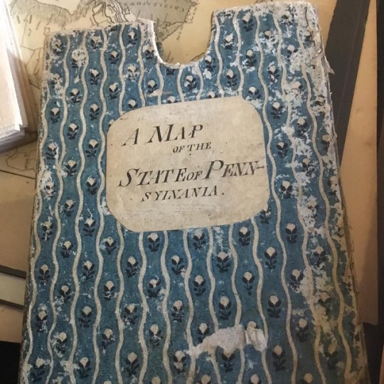
Look what walked in the gallery! Working now on consignment! Extremely beautiful, original color map. A Map of the State of Pennsylvania by Reading Howell, MDCCXCII To Thomas Mifflin Governor ... This . [Philadelphia and London]: for the Author and sold by James Phillips, George Yard, Lombard Street, London, 1792 Beautifully bright original hand colored map in case, in 40 segments mounted on linen, forming a whole 38 x 64 3/8 in. in upper right the cartouche in oval frame below a copyright statement by "Samuel Caldwell, Clerk of the District of Pennsylvania," #pennsylvania #pennsylvaniamaps #antiquepennsylvaniamaps #readinghowell #oldpamaps #antiquepamaps #raremaps #oldmaps #carolinaprints (at Carolina Antique Maps & Prints) https://www.instagram.com/p/BtEkRi5BWmX/?utm_source=ig_tumblr_share&igshid=1vmzzuxg3lblv
#pennsylvania#pennsylvaniamaps#antiquepennsylvaniamaps#readinghowell#oldpamaps#antiquepamaps#raremaps#oldmaps#carolinaprints
0 notes
Photo
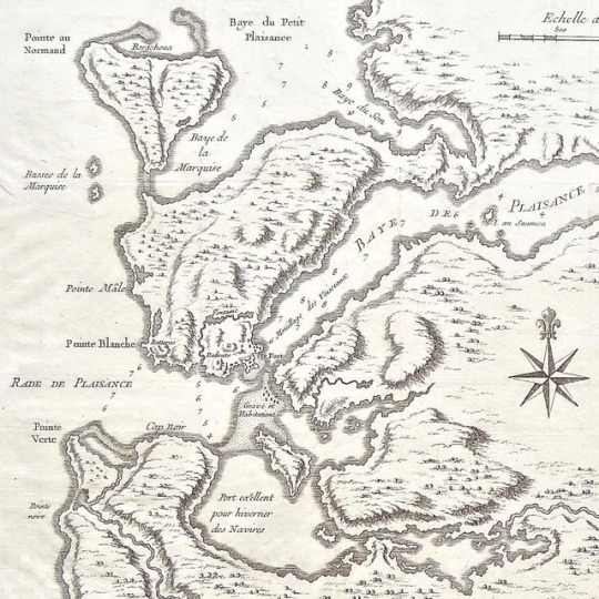
Today we head to Eastern Canada... 🇨🇦 'Carte des Bayes, Rades et Port de Plaisance dans l'Isle de Terre Neuve. Dressée sur les Manuscrits du Dépôt des Cartes, Plans, et Journaux de la Marine, par N. B. Ingénieur du Roy et de la Marine, 1744.' was drawn by Jacques Nicolas Bellin (marine engineer, hydrographer and cartographer to the King), and engraved on copper by Guillaume Dheulland. It was included in "Histoire et Description Generale de la Nouvelle France, avec Le Journal Historique d'un Voyage fair par Ordre du Roi dans L'Amerique Septentrionnale" by François Xavier de Charlevoix. It was published by Chez Rollin Fils of Quai des Augustins, à Saint Athanse, and au Palmier, à Paris in 1744. So this map is only 273 years outdated... it's quite incredible to imagine explorers charting these water and mapping the towns along the coasts, many of which are still expanding cities and ports today. And, on the bottom, you can see the bay where they found it best to keep the boats in the freezing winters. Though these waters may be a tad icy cold today, in the summer months they sure are stunning! ✏️🇨🇦🗺 #cartes #canada #canadianmap #map #mapofnewfoundland #newfoundland #explorenewfoundland #newfie #portdeplaisance #bay #terreneuve #canadianhistory #explorers #traveltheworld #antiquemaps #raremaps #mapsforsale #uniquegifts #giftfortraveler #wallmap #wallart #walldecor #inspiration #homedecor #details #interiordesign #getoutthere #livemore #travelcanada #keepongoing (at Baie de Plaisance)
#uniquegifts#terreneuve#explorenewfoundland#explorers#keepongoing#giftfortraveler#interiordesign#travelcanada#cartes#canadianhistory#raremaps#homedecor#bay#wallart#antiquemaps#newfoundland#portdeplaisance#canadianmap#mapofnewfoundland#getoutthere#traveltheworld#details#mapsforsale#canada#map#walldecor#newfie#wallmap#livemore#inspiration
5 notes
·
View notes
Photo
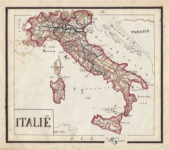
1871 Sikkel Manuscript Map of Italy https://www.geographicus.com/P/AntiqueMap/Italie-sikkel-1871 This is a beautiful 1871 manuscript map of Italy by J. C. Sikkel. The map is hand drawn in beautiful detail and includes the islands of Malta, Sardinia and Corsica. Topography is beautifully rendered throughout and important towns, cities, islands, rivers, etc. are noted. The islands of Sardinia and Corsica are included. @geographicusmaps #antiquemap #antiquemaps #raremap #raremaps #italy #italia #europe #europa #manuscript #travel #history #worldmap #vintagemap #vintagebooks #worldmap #maps (at Geographicus Rare Antique Maps) https://www.instagram.com/p/Bx-xmZwHedk/?igshid=2m6nm3tzooaw
#antiquemap#antiquemaps#raremap#raremaps#italy#italia#europe#europa#manuscript#travel#history#worldmap#vintagemap#vintagebooks#maps
3 notes
·
View notes
Photo
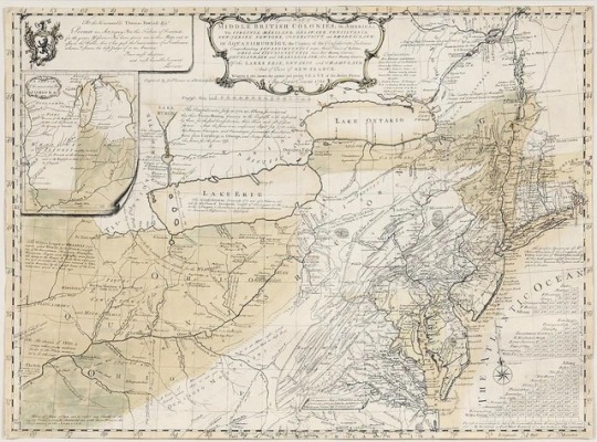
#Repost @brunkauctions ・・・ We are happy to present over 65 Rare and Important Maps from Colonial Williamsburg Foundation. All maps are being auctioned to benefit acquisitions. Pictured here is ‘A General Map of the Middle British Colonies’ by Lewis Evans. Evans is considered by experts to be the best geographer working in the British Colonies in his time. #brunk #auctions #maps #raremaps #lewisevans #evans #evansmap #auction #mapauction #cwf #colonialwilliamsburgfoundation #cartography #geography #atlas #auctionfinds http://ift.tt/2yUxQ3n
14 notes
·
View notes
Photo
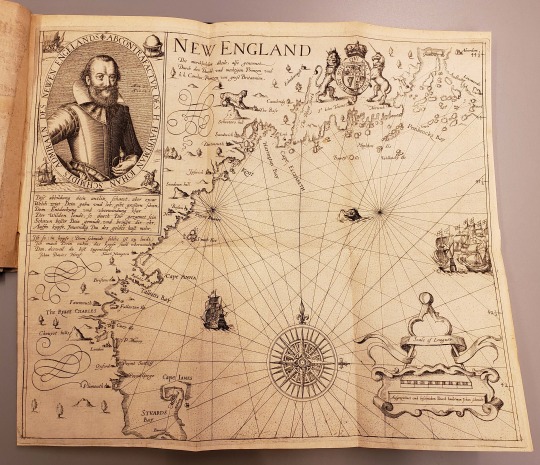
John Smith map of New England from: Hamor, Ralph, -1626. Ein warhafftiger vnd gründtlicher Bericht von dem jtzigen Zustandt der Landtschafft Virginien. Gedruckt zu Hanaw : in Verlegung der Hulsischen, 1617
F229 .H192 1617
#map#johnsmith#1617#newengland#17thcentury#seamonster#compass#compassrose#scalebar#ships#lion#atlanticocean#atlanticcoast#unicorn#rarebooks#specialcollections#libraryofva#raremaps
29 notes
·
View notes
Last Seen Blogs


taratchab
TARA

aristocratic-otter
Aristocratic_Otter

pathfinderhub
Pathfinder Hub

vam-piritz
˚₊‧ Shark