#ancientmap
Explore tagged Tumblr posts
Visit Tumblr Blog
Explore Tumblr blogs with no restrictions, modern design and the best experience.
Last Seen Tumblr Blogs


Fun Fact
Tumblr has a low social media market share in South America.
Link
#Jerusalem#Backholer#ByFaith#ByFaithMedia#ByFaithTV#KingHerod#AncientMapsoftheWorld#AncientMaps#AncientModel#ChristianPilgrimage#JerusalemOldCity#jerusalemoftheday#visitjerusalem#instaisrael#israeloftheday#christiantravel#christiantraveller#bibletravel#holyland#jerusalemcity#israel#visitisrael#BibleHistory#HistoryUncovered#BiblicalMaps#TowerOfDavid
2 notes
·
View notes
Text
youtube
Unlocking Ancient Wisdom: The Power of Old Maps #shorts Discover how ancient cartography shapes our understanding of history and science. These maps reveal the interconnectedness of human societies, trade routes, and cultural exchanges that have influenced our world. Join us in exploring the lessons of resilience and ingenuity embedded in these historical treasures!#AncientMaps #History #CulturalExchange #Resilience #Education https://www.youtube.com/watch?v=XOAx2WUOIso via BRIGHT INSIGHTS https://www.youtube.com/channel/UCJ6Vnlt6GxPk2SM59r_YByQ April 04, 2025 at 08:50PM
#earthmystery#ancientearth#ancienttechnology#prehistoric#wildlifeconservation#futureoftech#hiddenhistory#ancientmystery#Youtube
1 note
·
View note
Text
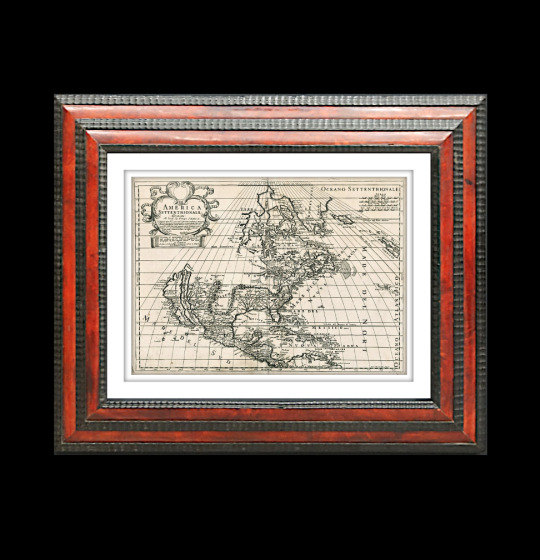
For Sale 🔥 Rare Old Map 1700, America Settentrionale, California As An Island.
https://www.busaccagallery.com/catalog.php?itemid=6439#
🔥 See some of the important maps from the early history of cartography at 🔥 Busacca Gallery.
#Cartography #AntiqueCartography #OldMaps #Maps #AntiqueMaps #RareMaps #AncientMaps #America #California #OldMap #CaliforniaMap #OldCalifornia #MapCollector #MapCollections #MapGallery #BusaccaGallery #ArtMap #MapPrint #MackDesign #InteriorDesign #FramedArt #FramedMap #HomeDecor #OfficeDecor #Luxury #LuxuryDesign
0 notes
Text
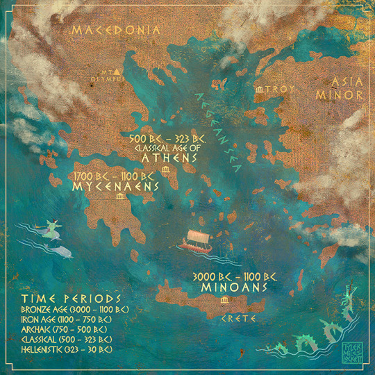
(**i drew this map and wrote this text for my upcoming book on greek hero myths. If you see any problems please let me know! Xoxo)
Certainly the ancient Greek myths were influenced and inspired by even older cultures like Egypt and Babylon (see Zeus parallels with Babylonian “Anu”) through “diffusion” (cultural spreading). But there were three powerful civilizations in ancient Greece which fostered a unique cultural and mythic heritage, spanning almost 3000 years.
MINOA: (3000 B.C.-1100 B.C.) In the Bronze age, on the southern island of Crete, rose a great civilization with a population of over 10,000 at the city of Knossos. The name derives from King Minos, of the Theseus and Minotaur myth. The Minoans were known for far-reaching Mediterranean sea trade, and wrote in a language called “Linear A,” which has never been deciphered.
MYCENAE: (1700 B.C.- 1100 B.C.) Another sea faring Bronze age civilization in which the Homeric characters hail from. With the Minoan civilization in decline around 1450 B.C., the Myceneans took over the islands and adopted much of the Minoan culture, developing a new writing system, “linear B,” which became the earliest Greek language. Whether due to invading foreigners or natural disasters, the decline of Mycenae was followed hundreds of years of decline; the “dark ages.” “Archaic” period (700-480 B.C.) Populations increased, and progressive concepts appeared, such as the creation and organization of the “Polis” or city-state.
ATHENS (480 B.C.- 323 B.C.) the word “Greece” was a later term created by the Romans. The ancient Athenian Greeks called their country “Hellas” and the people were “Hellenes.” the “Classical age” of Athens was a period of revolutionary development in philosophy; (Socrates, Plato, Aristotle,) theatre drama (Aeschylus, Sophocles, Euripides), refining concepts of democracy, among many other innovations in sculpture, architecture, and medicine.
#tagamemnon#mythology tag#greekmyths#greek myth retellings#pjo#percy jackson fanart#percy jackon and the olympians#percyjackson#classical literature#dark academia#hero myth#greekmap#ancientmap#mycenae#knossos#minoan#mycenaen#athens#classical age
199 notes
·
View notes
Photo

Happy Friday! Enjoy your weekend discovering world history with an old map. ⠀⠀⠀⠀⠀⠀⠀⠀⠀ Old Maps Library reprint map of Modern Palestine. Illustrations drawn by H.Warren & Engraved by R.Baker and Map drawn & engraved by J.Rapkin. This map has outline color by region with drawings of pelicans, a gazelle, natives, and two cities - Jaffa and Nazareth. Delicate design encloses the map. ⠀⠀⠀⠀⠀⠀⠀⠀⠀ ⏳ ⠀⠀⠀⠀⠀⠀⠀⠀⠀ ⏳ Old Maps Library specialises in the reprint of Vintage Maps and Illustrations between the 17th to 19th centuries. ⠀⠀⠀⠀⠀⠀⠀⠀⠀ 🔎 Our prints are linen backed by hand, this technique gives it more durability and a beautiful vintage finish look. ⠀⠀⠀⠀⠀⠀⠀⠀⠀ ⏳Linen backing is a technique that mapmakers used in the past as a solution to keep the maps stronger for long journeys and weather changes. ⠀⠀⠀⠀⠀⠀⠀⠀⠀ 🔎Nowadays, this technique is an important conservation method for restoring and preserving vintage maps and posters. ⠀⠀⠀⠀⠀⠀⠀⠀⠀ ⏳Our maps are folded and fitted into a marbled slipcase. ⠀⠀⠀⠀⠀⠀⠀⠀⠀ ⏳ ⠀⠀⠀⠀⠀⠀⠀⠀⠀ Are you also fascinated by old maps? ⠀⠀⠀⠀⠀⠀⠀⠀⠀ ⏳ We have a beautiful collection of Old Maps and Vintage Illustrations on our website. Link in our bio. ⠀⠀⠀⠀⠀⠀⠀⠀⠀ "Travel back to moments in time and discover the world heritage!" . . . #oldmap #vintagemap #raremap #location #mapnameyear #cartographer #antiquemap #ancientmap #gallerywalldecor #mapas #instamap #mapdecor #mapsarecool #mapsofinstagram #mapsandillustrations #homedecorationideas #maplove #lovemaps #mapshop #mapsoftheworld #oldword #antiquemapsandprints #framedmaps #map #mapart #wallframe #mapprints #mappe #oldmapslibrary #mapasantiguos (at London, Unιted Kingdom) https://www.instagram.com/p/CQ1INJyt3U7/?utm_medium=tumblr
#oldmap#vintagemap#raremap#location#mapnameyear#cartographer#antiquemap#ancientmap#gallerywalldecor#mapas#instamap#mapdecor#mapsarecool#mapsofinstagram#mapsandillustrations#homedecorationideas#maplove#lovemaps#mapshop#mapsoftheworld#oldword#antiquemapsandprints#framedmaps#map#mapart#wallframe#mapprints#mappe#oldmapslibrary#mapasantiguos
2 notes
·
View notes
Photo
LINK IN BIO 😉 #amsterdam #city #cutoutcity #art #etsy #cutouts #crafts #muralart #wallart #europe #travel #berlin #vintage #vintagemap #oldmap #ancientmap #map #sollewitt #centrepompidou #handmade #artoftheday #pictureoftheday #photooftheday #artist #artselection #artdaily #geography #topography #frame #decorideas (at Berlin, Germany) https://www.instagram.com/p/BzymuXuoc7Q/?igshid=1c0rzujrocv7a
#amsterdam#city#cutoutcity#art#etsy#cutouts#crafts#muralart#wallart#europe#travel#berlin#vintage#vintagemap#oldmap#ancientmap#map#sollewitt#centrepompidou#handmade#artoftheday#pictureoftheday#photooftheday#artist#artselection#artdaily#geography#topography#frame#decorideas
1 note
·
View note
Photo
A New and Accvrat Map of the World 1626 Wall Decor Gold-Silver Foil Art Print Framed แผนที่โลกโบราณพร้อมกรอบทำมาจากแผ่นโลหะบางสีเงินและทอง มีการพิมพ์ลวดลายแผนที่โลกที่คนสมัยปี ค.ศ.1626 เข้าใจลงไป มีลวดลายสวยงามมาก สะท้อนแสงวาวแวว ตัวแผนที่สภาพดีมาก ไม่มีตำหนิใดๆ กรอบอะลูมิเนียม กระจกพลาสติก ขนาดรูป 7×9 นิ้ว ขนาดกรอบรูป 12.5×10.5 หนา 5/8 นิ้ว 680 รวมส่ง ลทบ ems+20 #chiangmaisecondhand #tuckzchiangmaisecondhand #ancientmap https://www.instagram.com/p/CRnI3NEnTIg/?utm_medium=tumblr
0 notes
Photo
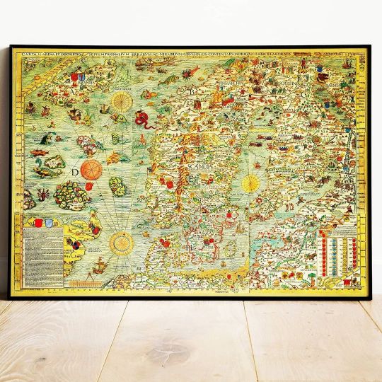
Old Map of Scandinavia, 1539 - Carta Marina by Olaus Magnus – The Medieval Nordic Monster Map - Nordic Countries Denmark, Sweden, Finland #cartamarina #scandinaviamap #medievalnordicmap #ancientmap #finlandmap #swedenmap #icelandmap #olausmagnus https://etsy.me/3tGEMtT (at Scandinavia) https://www.instagram.com/p/CNzqk1Nh1PG/?igshid=1lwice6ji4f4w
#cartamarina#scandinaviamap#medievalnordicmap#ancientmap#finlandmap#swedenmap#icelandmap#olausmagnus
0 notes
Photo
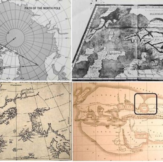
[Post-15] The ancient flood may be the mythological story but climate and land changes proof suggested by the ancient maps are indicating that event likely happened. https://tathastuu.com/2019/11/climatic-and-land-changes-suggested-by-the-ancient-maps.html #ancientmap #ancientaliens #ancient-history #antarctica https://www.instagram.com/p/B9fCp0fnPA7/?igshid=1so9nus4ucczm
0 notes
Photo
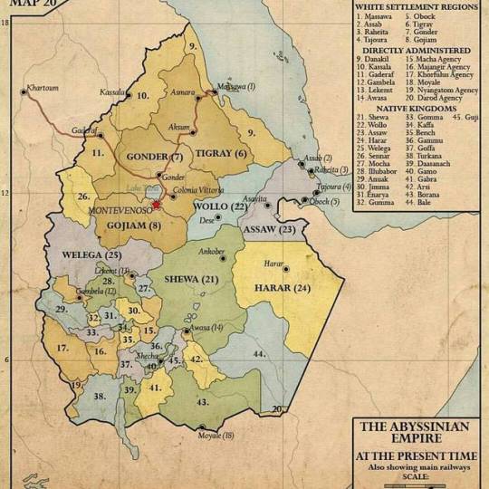
#RepostSave @historical.ethiopia with @repostsaveapp ・・・ 🇨🇬@historical.ethiopia 🇨🇬 Historical regiones of Ethiopia (first modified by the marxist derg junta and ultimately abolished by the ethnocentric TPLF dictatorship) #ethiopia #abyssinia #habesha #ethiopianhistory #cushitic #semitic #ethiosemitic #cushiticrace #cushites #northeastafrican #eastafrica #hornofafrica #northeastafrica #ancientmap #historicalarea #civilisation #ethiopianempire #ethio #ethiopian #ethiopians
#ethiopians#hornofafrica#ethio#eastafrica#cushitic#cushites#ethiopianhistory#northeastafrica#ethiopianempire#semitic#ethiopia#northeastafrican#habesha#ethiosemitic#ethiopian#historicalarea#repostsave#ancientmap#cushiticrace#abyssinia#civilisation
1 note
·
View note
Photo
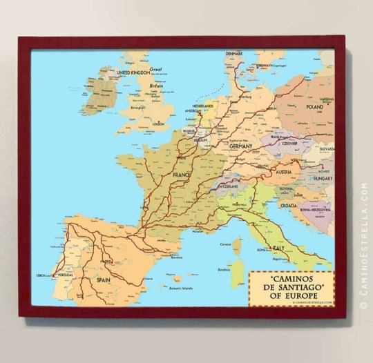
Caminos de Santiago of Europe map ✈️ Worldwide shipping 📎 Visit my shop for Camino de Santiago Art products: http://caminoestrella.com/shop http://www.etsy.com/shop/CaminoEstrella
#caminoestrella#map#ancientmaps#caminodesantiago#산티아고순례길#mapofeurope#maplover#historyofeurope#marcheffner#romanroads#caminofinisterremuxia#landkarte#caminodelnorte#caminodelaplata#chemindestjaques#caminoportugues#roadmap#caminofrances#camminodisantiago#maplovers#jakobsweg
3 notes
·
View notes
Text
youtube
The Sahara: A Green Paradise? #shorts Discover the astonishing truth about the Sahara's past! Once a lush and tropical paradise, this desert holds secrets that challenge our understanding of history. Could ancient maps reveal memories of a greener Sahara? Join us as we explore the Cantino Planisphere and its striking resemblance to modern scientific findings. Don't miss out on this fascinating journey into the Sahara's hidden history!#Sahara #AncientMaps #History #Education #LostCivilizations https://www.youtube.com/watch?v=eWq-SY2MobY via BRIGHT INSIGHTS https://www.youtube.com/channel/UCJ6Vnlt6GxPk2SM59r_YByQ April 04, 2025 at 12:00AM
#earthmystery#ancientearth#ancienttechnology#prehistoric#wildlifeconservation#futureoftech#hiddenhistory#ancientmystery#Youtube
0 notes
Photo
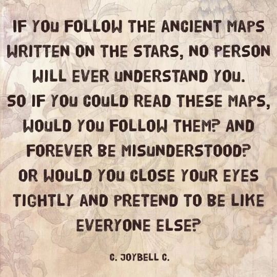
QUOTE OF THE DAY Sat, November 6, 2021 "If you follow the ancient maps written on the stars, no person will ever understand you. So if you could read these maps, would you follow them? And forever be misunderstood? Or would you close your eyes tightly and pretend to be like everyone else?" - C. JoyBell C.
~~~~~~~~~~~~~~~~~~~~~~~~~~~~~~~~~~~~~~~~~~~~~~~~~
See the original post on Instagram! Watch WGS on Twitch and YouTube!
#cjoybellc#cjoybellcquote#cjoybellcquotes#ancient#ancientmaps#destiny#inspirational#inspirationallife#inspirationalquotes#maps#mapswrittenonthestars#quoteoftheday#educational#educationalpost#educationalposts#learnsomethingneweveryday#becomesmartereveryday#becomempowered#bempowering#monriatitans#theweekendgameshow#wgs#goodreads#goodreadsquote
0 notes
Photo

Happy Wednesday!
⠀⠀⠀⠀⠀⠀⠀⠀⠀
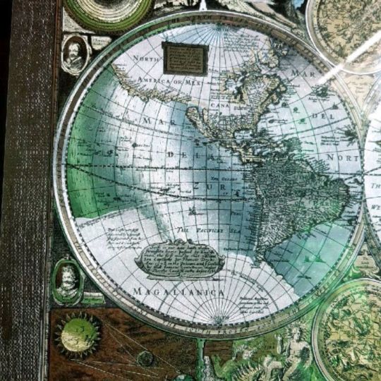
Shall we take another journey back in time through an old map?
We have today this beautiful reproduction map of North America by Herman Moll, circa 1719.
⠀⠀⠀⠀⠀⠀⠀⠀⠀
One of Herman Moll’s most famous maps often referred to as The Codfish Map.
⠀⠀⠀⠀⠀⠀⠀⠀⠀
As an enhancement to his “Map of North America,” Moll engraved orthographic or plan views of ten bays in North America and the Caribbean in the lower left-hand corner of the map. ⠀⠀⠀⠀⠀⠀⠀⠀⠀
Each bay was the location of a major port city and harbour. ⠀⠀⠀⠀⠀⠀⠀⠀⠀
Five of the port cities were British (St. John’s, Boston, New York, Charleston, and Port Royal) and five were Spanish (Havana, Portobello, Vera Cruz, Cartagena, and Acapulco). ⠀⠀⠀⠀⠀⠀⠀⠀⠀
Moll engraved the insets in the style of navigational charts complete with numbers on some of the charts representing depth soundings in fathoms.
⠀⠀⠀⠀⠀⠀⠀⠀⠀
Herman Moll (1654?-1732) was a London cartographer, engraver, and publisher. ⠀⠀⠀
⠀⠀⠀⠀⠀⠀⠀⠀⠀
Visit our online shop for more old maps & Vintage Illustrations.
⠀⠀⠀⠀⠀⠀⠀⠀⠀
Link in Bio
.
.⠀⠀⠀⠀⠀⠀
.
#oldmap #vintagemap #raremap #northamericamap #mapofnorthamerica #cartographer #antiquemap #ancientmap #gallerywalldecor #mapas #instamap #mapdecor #mapsarecool #mapsofinstagram #mapsandillustrations #homedecorationideas #maplove #lovemaps #mapshop #mapsoftheworld #oldword #antiquemapsandprints #framedmaps #map #mapart #wallframe #mapprints #mappe #oldmapslibrary #mapasantiguos (at London, Unιted Kingdom)
https://www.instagram.com/p/CLcDgt5pmNZ/?igshid=q84prq89pwf4
#oldmap#vintagemap#raremap#northamericamap#mapofnorthamerica#cartographer#antiquemap#ancientmap#gallerywalldecor#mapas#instamap#mapdecor#mapsarecool#mapsofinstagram#mapsandillustrations#homedecorationideas#maplove#lovemaps#mapshop#mapsoftheworld#oldword#antiquemapsandprints#framedmaps#map#mapart#wallframe#mapprints#mappe#oldmapslibrary#mapasantiguos
1 note
·
View note
Photo

LINK IN BIO 😉 #amsterdam #city #cutoutcity #art #etsy #cutouts #crafts #muralart #wallart #europe #travel #berlin #vintage #vintagemap #oldmap #ancientmap #map #sollewitt #centrepompidou #handmade #artoftheday #pictureoftheday #photooftheday #artist #artselection #artdaily #geography #topography #frame #decorideas https://www.instagram.com/p/BzztHm9iTzS/?igshid=lxttbam3eyi7
#amsterdam#city#cutoutcity#art#etsy#cutouts#crafts#muralart#wallart#europe#travel#berlin#vintage#vintagemap#oldmap#ancientmap#map#sollewitt#centrepompidou#handmade#artoftheday#pictureoftheday#photooftheday#artist#artselection#artdaily#geography#topography#frame#decorideas
0 notes
Photo

1000 #clementoni #photo by:@elrompecabezasdeamalia #map #ancientmap #jigsawpuzzle #puzzle #پازل #eurographics #ravensburger #educa #heye #schmidt #artpuzzle #piatnik #clementonipuzzle #trefl #dtoys #deico #jigsaw #پیاتنیک #رونزبرگر #ادوکا #اشمیت #ترفل #آناتولین #آرت_پازل #anatolian مشاهده اطلاعات و خرید در فروشگاه اینترنتی پازل ایران https://puzzleiran.com https://www.instagram.com/p/CDUNl6VB4wA/?igshid=1drsfaop6800v
#clementoni#photo#map#ancientmap#jigsawpuzzle#puzzle#پازل#eurographics#ravensburger#educa#heye#schmidt#artpuzzle#piatnik#clementonipuzzle#trefl#dtoys#deico#jigsaw#پیاتنیک#رونزبرگر#ادوکا#اشمیت#ترفل#آناتولین#آرت_پازل#anatolian
0 notes