#smartdrones
Explore tagged Tumblr posts
Visit Tumblr Blog
Explore Tumblr blogs with no restrictions, modern design and the best experience.
Last Seen Tumblr Blogs


Fun Fact
In 2020, 27% of US Tumblr users had an annual household income of over $100,000.
Text

Comary - Teresópolis
#Foto#fotografia#photo#Photography#paisagem#landscape#RJ#dronestagran#colors#MCalvetPhotos#mcalvet_photos#MCalvetPhotography#mcalvet_photography#mcalvet#MCalvet#Aerialdynamics#ig_color#superb_photos#dronefolio#DroneOfTheDay#TheDroneCommunity#dronewise#smartdrones#djiglobal#dji4K#dronephoto#dronekoning#twenty4sevendrones#djibrasil#djicreator
2 notes
·
View notes
Text

A high-tech drone designed for real-time aerial monitoring, photography, and data collection. Featuring a powerful camera, stable flight controls, and smart connectivity, it ensures efficiency in industries like surveillance, mapping, and environmental monitoring. Unlock in-depth details on our website!
www.auckam.com
0 notes
Text
Capture Stunning Aerial Photos and Videos with Phone Parts NZ's Smart Drones
Upgrade your photography game with a high-tech smart drone from Phone Parts NZ. Explore new perspectives, capture unforgettable moments, and create professional-quality content with ease. Shop our selection of user-friendly drones today and experience the thrill of flight!

0 notes
Text
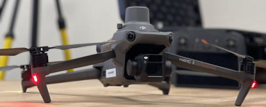
DJI Mavic 3 Enterprise Series: Redefining Aerial Technology
DJI Mavic 3 Enterprise Series: Redefining Aerial Technology
In the world of commercial drones, the DJI Mavic 3 Enterprise series stands out as a testament to innovation and versatility. With a focus on providing advanced features tailored to various industries, this series has redefined the possibilities of aerial technology.
Unveiling the DJI Mavic 3 Enterprise Series
The DJI Mavic 3 Enterprise series is a line of commercial drones designed for a variety of industries, including public safety, construction, and inspection. It is the most advanced and capable drone in DJI's Mavic lineup, with features that set it apart from the competition.
Advanced Camera System
At the core of the Mavic 3 Enterprise series is a dual-camera system that includes a 20MP wide-angle camera and a 56× zoom camera. This powerful combination allows users to capture high-resolution images and videos from impressive distances, providing a new dimension to aerial photography and videography.
Thermal Imaging Capability
The Mavic 3T variant, in particular, boasts a thermal camera for day and night inspections. Thermal imaging is invaluable for applications such as identifying heat signatures, detecting anomalies, and assessing temperature differentials in various environments.
Precise Positioning
For industries that demand pinpoint accuracy, the Mavic 3 Enterprise series comes equipped with an RTK (Real-Time Kinematic) module. This module ensures centimeter-level positioning accuracy, a vital feature for tasks like precise mapping, surveying, and geospatial applications.
Extended Flight Time
The Mavic 3 Enterprise series offers an impressive flight time of up to 45 minutes, significantly enhancing operational efficiency by providing more time in the air before needing to recharge.
Intelligent Flight Modes
These drones come with a suite of intelligent flight modes and features, including Spotlight 2.0, ActiveTrack 5.0, and SmartPhoto. These functions simplify complex tasks and enhance the capabilities of the drone, making it easier for operators to achieve their goals.
Accessory Compatibility
The Mavic 3 Enterprise series is not limited to its built-in capabilities. It is also compatible with a range of accessories, such as a speaker, spotlight, and beacon, which further expand its utility across diverse applications.
Diverse Applications
The Mavic 3 Enterprise series is a versatile tool that caters to a multitude of industries and applications:
Mapping and Surveying
These drones are ideal for creating precise maps and surveys of expansive areas, including construction sites, farms, and disaster zones. The data collected can be instrumental in planning and decision-making.
Inspection
Infrastructure inspections, from bridges to power lines, benefit greatly from the Mavic 3 Enterprise series' capabilities. Detecting damage early can prevent costly failures and ensure public safety.
Search and Rescue
In search and rescue operations, drones provide invaluable assistance in locating missing individuals and assessing the extent of damage caused by natural disasters. Their aerial perspective aids in efficient deployment of resources and swift response.
Firefighting
In firefighting efforts, the Mavic 3T can assess fire damage, track wildfire progression, and provide invaluable situational awareness to first responders.
In essence, the DJI Mavic 3 Enterprise series is a powerful and adaptable tool that enhances the capabilities of various industries. Its ease of use and ability to deliver high-quality images and videos make it an indispensable asset for organizations seeking cutting-edge solutions to their unique challenges.
The Top 10 Drones for Industrial Inspections
Here is a list of the top 10 drones for industrial inspections, in no particular order:
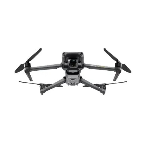
1. DJI Mavic 3 Enterprise Advanced
DJI Mavic 3 Enterprise Advanced drone
· Pros: Long flight time, dual-camera system with zoom lens, thermal camera option, RTK module for centimeter-level accuracy, intelligent flight modes and features
· Cons: Expensive
2. DJI Matrice 300 RTK
DJI Matrice 300 RTK drone
· Pros: Long flight time, powerful camera system with zoom lens, thermal camera option, RTK module for centimeter-level accuracy, obstacle avoidance system, modular design for attaching different payloads
· Cons: Expensive, large and heavy
3. Flyability Elios 3
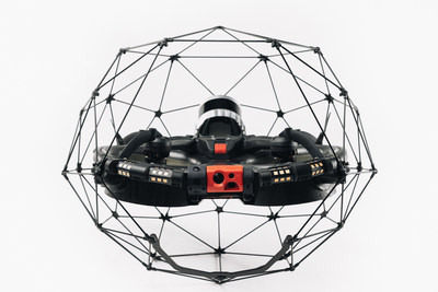
Flyability Elios 3 drone
· Pros: Unique design allows it to fly in confined spaces, impact-resistant cage, thermal camera option, long flight time
· Cons: Expensive, can be difficult to fly in windy conditions
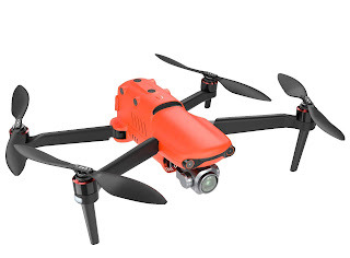
4. Parrot Anafi USA

Parrot Anafi USA drone
· Pros: Compact and lightweight, affordable, high-quality camera system, zoom lens
· Cons: Short flight time, no RTK module
5. Autel Robotics EVO II Pro
Autel Robotics EVO II Pro drone
· Pros: Long flight time, high-quality camera system with zoom lens, obstacle avoidance system, affordable
· Cons: No RTK module
6. senseFly eBee X
senseFly eBee X drone
· Pros: Long flight time, high-quality camera system, accurate mapping and surveying capabilities
· Cons: Can be difficult to fly in windy conditions, expensive
7. Skyward Vertical Take-Off and Landing (VTOL) Drone
Skyward Vertical Take-Off and Landing (VTOL) Drone
· Pros: Can take off and land vertically, long flight time, high-quality camera system, RTK module
· Cons: Expensive, large and heavy
8. Inspire 2
Inspire 2 drone
· Pros: Powerful camera system with zoom lens, thermal camera option, obstacle avoidance system, modular design for attaching different payloads
· Cons: Expensive, large and heavy
9. Phantom 4 RTK
Phantom 4 RTK drone
· Pros: Long flight time, high-quality camera system, RTK module for centimeter-level accuracy
· Cons: No zoom lens, expensive
10. AscTec Falcon 8
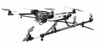
AscTec Falcon 8 drone
· Pros: Robust and reliable, long flight time, high-quality camera system, RTK module
· Cons: Expensive
When choosing a drone for industrial inspections, there are a number of factors to consider, such as:
· Flight time: How long does the drone need to be able to fly for?
· Camera system: What type of camera system does the drone need to have? (e.g., zoom lens, thermal camera, high resolution)
· Accuracy: How accurate does the drone need to be? (e.g., RTK module)
· Obstacle avoidance: Does the drone need to have obstacle avoidance?
· Payload capacity: Does the drone need to be able to carry any additional payloads? (e.g., sensors, lights)
· Price: How much is the user willing to spend?
It is also important to consider the specific needs of the inspection application. For example, if the drone needs to fly in confined spaces, then a drone like the Flyability Elios 3 would be a good choice. If the drone needs to have a long flight time, then a drone like the DJI Mavic 3 Enterprise Advanced or the DJI Matrice 300 RTK would be a good choice.
Once you have considered all of these factors, you can start to narrow down your choices and choose the best drone for your needs.
Certainly, here are some frequently asked questions (FAQs) related to the DJI Mavic 3 Enterprise Series and industrial drones for inspections:
1. What industries can benefit from the DJI Mavic 3 Enterprise Series?
- The DJI Mavic 3 Enterprise Series is designed for a wide range of industries, including public safety, construction, inspection, mapping and surveying, search and rescue, firefighting, and more.
2. What are the key features of the DJI Mavic 3 Enterprise Series?
- The key features include a dual-camera system, thermal imaging capability, precise positioning with an RTK module, extended flight time, intelligent flight modes, and compatibility with various accessories.
3. How long can the DJI Mavic 3 Enterprise Series drones fly on a single charge?
- The Mavic 3 Enterprise Series offers an impressive flight time of up to 45 minutes, which significantly enhances operational efficiency.
4. What are RTK modules, and why are they important for industrial inspections?
- RTK (Real-Time Kinematic) modules provide centimeter-level positioning accuracy, which is crucial for tasks like precise mapping, surveying, and geospatial applications in industrial inspections.
5. Can the DJI Mavic 3 Enterprise Series be customized with accessories?
- Yes, these drones are compatible with a range of accessories such as a speaker, spotlight, and beacon, which can expand their utility for various applications.
6. What factors should I consider when choosing a drone for industrial inspections?
- Factors to consider include flight time, camera system capabilities (e.g., zoom lens, thermal camera), accuracy (e.g., RTK module), obstacle avoidance, payload capacity, and budget.
7. Are there any drones suitable for flying in confined spaces?
- Yes, drones like the Flyability Elios 3 are designed with a unique cage-like structure that allows them to fly in confined spaces and are suitable for inspections in such environments.
8. Are there affordable options for industrial drones with good camera systems?
- Yes, options like the Parrot Anafi USA and Autel Robotics EVO II Pro are more affordable while still offering high-quality camera systems.
9. What is the advantage of having a thermal camera for industrial inspections?
- Thermal cameras are invaluable for detecting heat signatures, identifying anomalies, and assessing temperature differentials, which is useful in various inspection applications, such as identifying electrical issues or assessing structural integrity.
10. How can drones assist in firefighting efforts?
- Drones like the Mavic 3T can assess fire damage, track wildfire progression, and provide situational awareness to first responders, helping them make informed decisions and improve firefighting effectiveness.
Read More:-DJI Drone Price in UAE - Explore the Best Deals on Aerosmart.ae
#Drones#IndustrialInspections#AerialTechnology#DJIMavic3#DJIEnterprise#ThermalImaging#PrecisionMapping#AerialPhotography#SearchAndRescue#FirefightingDrones#DroneTech#GeospatialMapping#PublicSafety#ConstructionInspection#SurveyingDrones#DroneInnovation#SmartDrones#DroneAccessories#DroneFlight#AerialVideo
0 notes
Text

EFT will participate in the 2024 AGRI WEEK in Japan,
With our new agricultural drone——Z20.
Dedicated to single-person operation,
Specialized for small-acre fields.
Looking forward to your visit.
Meet us at AGRI WEEK TOKYO!
Date:October 9th to 11th,2024
Location:Makuhari Messe,Chiba,Japan
Booth number:8Hall.6-21
#EFT#EFTdrone#agriculturaldrone#Japan#EFTz20#z50#E410P#droneframe#dronetech#sprayingdrone#smartdrone#UAV#precisionagriculture#AgDroneTech#quadcopter#qualitydrone#dronesolutions#tokyo#agriweek#2024expo#expo#農業#農業用ドローン#幕張メッセ#東京#ドローン#クワッドコプター#精密農業#ドローンフレーム#噴霧ドローン
0 notes
Text
🚁 Hydrogen Delivery Drones Market Soars to $3.2B by 2034
Hydrogen-Powered Delivery Drones Market is redefining aerial logistics through eco-friendly, efficient solutions. Powered by hydrogen fuel cells, these drones offer extended flight durations and significantly lower emissions compared to battery-operated counterparts. This rapidly growing market encompasses manufacturers, hydrogen fuel cell suppliers, and service providers, supporting advancements across logistics, e-commerce, and emergency services. By leveraging hydrogen technology, stakeholders are paving the way for sustainable aerial transport.
To Request Sample Report: https://www.globalinsightservices.com/request-sample/?id=GIS10994 &utm_source=SnehaPatil&utm_medium=Article
The commercial delivery segment leads the market, driven by the rapid expansion of e-commerce and the need for efficient, green transportation solutions. Emergency services represent the second-largest segment, utilizing drones for disaster relief and medical supply deliveries, especially in remote areas. Regionally, North America dominates due to advanced technology and supportive regulations, with the United States excelling thanks to robust innovation ecosystems and significant funding. Europe follows closely, led by Germany’s strong emphasis on carbon reduction and renewable energy integration.
Key market segmentation includes types such as fixed-wing, rotary-wing, and hybrid drones, with applications ranging from e-commerce and healthcare to disaster relief and agricultural logistics. In 2023, the market saw substantial interest in sustainable logistics, with projections of reaching 1.2 million units by 2033. Commercial delivery drones currently command 45% of the market, followed by emergency services at 30%, and agriculture at 25%, reflecting growing adoption in precision farming.
Key players like Zipline and Wing Aviation are leading the competitive landscape, heavily investing in hydrogen fuel cell advancements. Despite challenges like high costs and limited infrastructure, projections indicate a 15% annual growth rate, driven by innovations in hydrogen storage and autonomous navigation systems. As regulations and incentives evolve, this market promises a greener future for global logistics.
#GreenLogistics #HydrogenDrones #SustainableDelivery #EcoFriendlyTech #DroneInnovation #HydrogenFuelCells #EcommerceSolutions #ZeroEmissions #AerialLogistics #HydrogenTechnology #RenewableEnergy #GreenTransportation #PrecisionFarming #DroneRevolution #HydrogenEconomy #CleanEnergySolutions #SmartDrones #DisasterReliefTech #FutureOfLogistics #HydrogenPowered #AdvancedLogistics #DroneSustainability #CarbonReduction #GreenInnovation #HydrogenForGoo
0 notes
Text
"The Brain of Drones: Exploring the Onboard Computer Market (2024-2033)"
Drone Onboard Computer Market : Drone onboard computers are at the heart of modern UAV (Unmanned Aerial Vehicle) technology, enabling real-time data processing, navigation, and decision-making capabilities. These compact, high-performance systems manage everything from flight control to obstacle avoidance, transforming drones from simple remote-controlled devices to autonomous aerial platforms. With industries like agriculture, logistics, and defense increasingly relying on drones for critical operations, onboard computers ensure precision, efficiency, and safety, driving innovation across sectors.
Download PDF Sample Report@https://www.globalinsightservices.com/request-sample/GIS25930/?utm_source=SnehaPatil-Article
The integration of AI and machine learning into drone onboard computers is pushing the boundaries of what’s possible. Drones can now perform complex tasks such as real-time image recognition, route optimization, and predictive maintenance, all while improving flight stability and energy efficiency. This technological leap is empowering industries to adopt drones on a larger scale, unlocking new opportunities in automation, surveillance, and data collection.
#DroneTechnology #UAVInnovation #AutonomousFlight #OnboardComputers #AIIntegration #SmartDrones #AerialSurveillance #PrecisionAgriculture #LogisticsRevolution #MachineLearning #FlightControl #TechInnovation
0 notes
Text
"Navigating the Skies: Insights into Drone Onboard Computer Innovations"
Drone onboard computers are redefining what’s possible in the world of unmanned aerial vehicles (UAVs). Acting as the brain of modern drones, these compact yet powerful systems handle everything from navigation to real-time data processing. With advanced AI and machine learning capabilities, onboard computers enable drones to autonomously make split-second decisions, adapt to changing environments, and perform complex tasks like object detection, route optimization, and obstacle avoidance. This makes them indispensable for applications ranging from aerial mapping to precision agriculture and beyond.
The integration of cutting-edge sensors and high-performance processors is taking drone technology to new heights—literally! As industries continue to adopt drone technology for everything from logistics to security, having a robust and efficient onboard computer is crucial for ensuring operational safety and efficiency. With features like real-time video streaming, GPS tracking, and even thermal imaging, today’s drone onboard computers are more advanced than ever, pushing the boundaries of what drones can achieve in both commercial and recreational use. 🚁
#DroneTech #AI #UAV #SmartDrones #TechInnovation #Automation #MachineLearning #AerialMapping #FutureTech #IoT
0 notes
Text
SmartDrones Air 2 Photos Leaked
Far far away, behind the word mountains, far from the countries Vokalia and Consonantia, there live the blind texts. Separated they live in Bookmarksgrove right at the coast of the Semantics, a large language ocean. A small river named Duden flows by their place and supplies it with the necessary regelialia. It is a paradisematic country, in which roasted parts of sentences fly into your…

View On WordPress
0 notes
Photo

Grzybowska! Warsaw! 🌍 . . . ______________ BMBDRON. @bmbdron www.bmbdron.com [email protected] ______________ . . . #drone #droneoftheday #dronelife #quadcopter #dronefly #dronephoto #aerialphotography #dronepics #dronepointofview #droneworld #dronegear #droneheroes #droneshots #dronestagram #instadrone #warszawa #warsaw🇵🇱 #warsawbynight #droneoperator #smartdrones #aerialphoto #skyphotography #skyphoto #sky #warsawpoland #polska🇵🇱 #dronedose #dronedaily #instadrone (w: Warsaw, Poland) https://www.instagram.com/bmbdron/p/BwJeWgngH99/?utm_source=ig_tumblr_share&igshid=8b2xj8lhjgko
#drone#droneoftheday#dronelife#quadcopter#dronefly#dronephoto#aerialphotography#dronepics#dronepointofview#droneworld#dronegear#droneheroes#droneshots#dronestagram#instadrone#warszawa#warsaw🇵🇱#warsawbynight#droneoperator#smartdrones#aerialphoto#skyphotography#skyphoto#sky#warsawpoland#polska🇵🇱#dronedose#dronedaily
7 notes
·
View notes
Photo

Epicness from @federico.sette• • • • •Felt so much in love with this country that I spontaneously decided to go back next week! Can’t wait to see everything covered in snow 😍❄️ #iceland #travel #travellingthroughtheworld #bestvacations_______________________Put us in your story!Follow @droneswaggerTag #droneswagger_______________________#dronelife #drone#droneoftheday #dronedaily #quadcopter #dronepilot #djicreator #smartdrones#djiglobal #aerialphotography #djiphantom #dronephotography #dronefly #droneshots #djimavic2pro #djimavicpro #djispark #dronestagram #godrone
#iceland#travel#travellingthroughtheworld#bestvacations#droneswagger#dronelife#drone#droneoftheday#dronedaily#quadcopter#dronepilot#djicreator#smartdrones#djiglobal#aerialphotography#djiphantom#dronephotography#dronefly#droneshots#djimavic2pro#djimavicpro#djispark#dronestagram#godrone
5 notes
·
View notes
Text

Comary - Teresópolis
#Foto#fotografia#photo#Photography#paisagem#landscape#RJ#dronestagran#colors#MCalvetPhotos#mcalvet_photos#MCalvetPhotography#mcalvet_photography#mcalvet#MCalvet#Aerialdynamics#ig_color#superb_photos#dronefolio#DroneOfTheDay#TheDroneCommunity#dronewise#smartdrones#djiglobal#dji4K#dronephoto#dronekoning#twenty4sevendrones#djibrasil#djicreator
3 notes
·
View notes
Text
Smart Drones Buying Guides
Drones are quickly becoming an essential tool of modern life. Smart drones are a step forward, bringing new levels of automation and efficiency to the way people use drones. In this blog post, we'll explore the potential of smart drones and how they can be used to improve our lives.
Automated Navigation
Smart drones are equipped with advanced navigation systems that allow them to be flown autonomously. This means that drones can be programmed to fly to designated locations, avoiding obstacles along the way. This makes it much easier to use drones for tasks such as delivering goods, as they can be sent to a location without human intervention.
Improved Safety
Smart drones are also equipped with sophisticated safety systems that can detect potential hazards. This means that drones can avoid obstacles and obstacles can be avoided to reduce the risk of an accident. Additionally, smart drones can be programmed to avoid areas where people may be present, making them much safer to use.
Increased Efficiency
Smart drones are also much more efficient than traditional drones. This is because they can be programmed to perform specific tasks, such as taking photos or recording video. Additionally, smart drones can be used in a range of applications, including industrial and commercial use, making them incredibly versatile.
Conclusion
Smart drones are ushering in a new era of automation and efficiency. They are equipped with advanced navigation and safety systems, allowing them to be flown autonomously and with increased safety. Additionally, they are more efficient than traditional drones, making them ideal for a range of applications. With more advanced technology on the horizon, smart drones are set to revolutionize the way we use drones. Read the full article
0 notes
Photo

Someone found a good way to spend the afternoon. #capenaturaliste #castlebay . . . . #droneimageaus #droneimagewa #dronephotography #drone #dji #thisiswa #australia #seeaustralia #fromwhereidrone #droneoftheday #drones #dronestagram #quadsnaps #flightography #dronelife #instadrone #uav #smartdrones #westernaustralia #dronespace #mavic #droneporn #dronepointofview #iamdji #earthfocus #flying #droneofficial #drones #ocean (at Castle Rock Meelup) https://www.instagram.com/p/CJ2oyaRMtQm/?igshid=1hblhkf2zjk7
#capenaturaliste#castlebay#droneimageaus#droneimagewa#dronephotography#drone#dji#thisiswa#australia#seeaustralia#fromwhereidrone#droneoftheday#drones#dronestagram#quadsnaps#flightography#dronelife#instadrone#uav#smartdrones#westernaustralia#dronespace#mavic#droneporn#dronepointofview#iamdji#earthfocus#flying#droneofficial#ocean
0 notes
Photo

Washington Square #worcesterma • • • • #drone #drones #dronestagram #dronepic #dronephotography #dronephoto #dronephotos #SmartDrones #dronepilots #dji #djiglobal #dronesforgood #djiphantom3 #djing #discovererdrone #dronedaily #multicopter #dronefly #dronefolio #aerialphotography #quadcopter #aerials #uav #dronelife #droneview #DroneOfTheDay #dronebusiness #lookdown #fromwhereidrone (at Union Station (Worcester, Massachusetts))
#lookdown#worcesterma#dronepic#aerials#discovererdrone#smartdrones#aerialphotography#droneview#dronebusiness#djiphantom3#dronephoto#dronedaily#droneoftheday#dronestagram#dronefly#djing#djiglobal#quadcopter#dronepilots#dronesforgood#drones#dronephotos#drone#dronelife#dji#dronephotography#uav#multicopter#fromwhereidrone#dronefolio
7 notes
·
View notes
Text
"Future Flight: Trends and Forecast for the Drone Sensors Market (2024-2033)"
Drone sensors are revolutionizing industries with their unparalleled precision and versatility. These advanced sensors enable drones to capture high-resolution imagery, gather real-time data, and perform complex tasks with remarkable accuracy. From agriculture and construction to environmental monitoring and disaster management, drone sensors are transforming the way we collect and analyze information. Equipped with cutting-edge technologies such as LiDAR, thermal imaging, and multispectral cameras, drones can detect subtle changes in crops, map out detailed terrain, monitor wildlife, and even assist in search and rescue operations. The integration of AI and machine learning further enhances their capabilities, allowing for smarter data processing and decision-making. As the demand for efficient and accurate data collection grows, drone sensors stand at the forefront of innovation, paving the way for smarter, safer, and more efficient solutions across various sectors.
#DroneTechnology #SmartDrones #LiDAR #ThermalImaging #AerialMapping #PrecisionAgriculture #ConstructionTech #EnvironmentalMonitoring #SearchAndRescue #WildlifeConservation #TechInnovation #DroneData #AI #MachineLearning #RemoteSensing #DroneApplications #UAV #TechRevolution #FutureOfDrones #DataCollection
0 notes