#the canyon where condors nested
Text
https://ictnews.org/news/condors-are-coming-back-to-the-pacific-northwest
#condors#pacific northwest#nez perce#Columbia river basin#snake river basin#Hells Canyon#Nimiipuu#the canyon where condors nested#Vultures of the Columbia
1 note
·
View note
Text
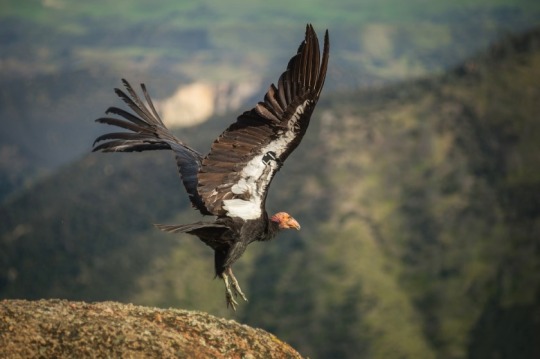
There is a Nez Perce name for condors: qu’nes (distinct from the word for the turkey vulture, q’ispa’laya, a similar bird locally differentiated by its bent wing profile). And the great bird historically lived here, in the Palouse Prairie, Hells Canyon, and the inland Pacific Northwest along the slopes of the Northern Rockies. The bird was here not during some lost ancient “primordial” Pleistocene past, but recently; the bird lived here relatively few decades ago. “California” condors living quite far from California. These local names for were relayed to scholar Brian Sharp, and there are other condor-names from the Pacific Northwest (also recorded by Sharp). There is a Wasco word for condors, k’unwakshun (according to scholars of the Warm Springs’ Wasco language program, distinct from the word for turkey vulture, q’ispa’laya), evidencing the bird’s presence at the Dalles, along the inland Columbia River, and in the Blue Mountains. From near the sagebrush steppe east of the Cascades, a Yakama word: patsami hu’u, “rough or crooked beak” (according to scholars of the Yakama Cultural Center). There is lakessltl’nos, possibly the word for condor, which is distinct from the turkey vulture, hem-letet (”stinkhead,” according to Johnson of the Grande Ronde Tribe Cultural Affairs Program). Condor bones exist on islands in the Salish Sea. Sonny McHalsie Naxaxalhts’i (researcher of cultural heritage and Salish place names) identifies a Salish Sto:lo name for condor from the Fraser River: sxwe-xwo:s, “opening his eyes.”
The “official” story as reported in most literature from settler-colonial land management agencies is that condors disappeared from the Pacific Northwest before the 20th century. There are records, even from the mid-20th century, of condors glimpsed flying over the Cascades in the Pacific Northwest, sometimes far from the coast.
Why are Native observations of condors -- from the Pacific Northwest as recently as the 1950s and 1960s -- generally ignored?
Because of the locations of the last remaining populations of the bird (the Grand Canyon, Mojave Desert, canyonlands of southern Utah, and southern California), condors might be associated in popular consciousness with arid landscapes and deserts. A distribution map of where condors survive in the 21st century would give the impression that the bird is associated solely with California deserts of the so-called “American Southwest”. (The Hopi Cultural Office references a Hopi name for condor, kwaatoko, “big eagle.”) But as recently as the early 1800s, the bird apparently still lived all along the coast between the deserts and chaparral of Baja California, past the foggy redwoods forests, to the Garry oak savanna of Vancouver Island, the Gulf Islands, and the Fraser Delta of present-day Vancouver, on the edges of rainforest and beneath the Pacific Northwest’s glaciers.
-------
During the early Holocene, the California condor apparently lived across the mountains of western North America (and perhaps some birds traveled father eastward into the continent, with Pleistocene fossils found in Texas and elsewhere). But in recent centuries, condors seem associated with the Pacific coastline (maybe similar to how the bird’s counterpart, the Andean condor, lives in a narrow corridor along the Pacific coastline of South America, which shares the climate and environments -- including chaparral, temperate rainforest, and desert -- of the coast of North America, at mirrored latitudes). Early Russian colonizers, traveling from the Aleutian Islands and Alaska towards northern California, reported the condor along the shores of the North Pacific.
How far inland, away from the sea, could condors travel? There are reports from 1818 of what are likely condors living in Hells Canyon, far away from the coast. Condors were also glimpsed above the Snake River Plain near present-day Boise. Into the 1890s, condors were (possibly/probably?) observed over the Rocky Mountain Front in present-day Alberta, where the prairies of the edge of the Great Plains meet the steep Rockies. (This is reported in a 1951 academic article, “Was the California condor known to the Blackfoot ...?”, which also describes a history of apparent condors feeding on bison carcasses.). In 1897, Fannin (who Sharp describes as “perhaps the most highly respected ornithologist in British Columbia”) caused debate when he reported a sighting of condors near Calgary; that same year, a condor was reportedly observed on the Blackfoot reservation in Montana along the Rocky Mountain Front (just south of the Alberta border).
-------
Some remain very skeptical of the existence of a few condors in the Northern Rockies, so far inland. What is more generally accepted, though, is that condors were residents in the coastal Pacific Northwest and what is now called “eastern Washington.” However, some settler-colonial scholars continued to doubt the possibility that condors were regular, year-round, permanent residents. Evidence for this permanent residency (as opposed to mere seasonal migration from California) includes Native oral histories from multiple tribes and in multiple languages; great numbers of condors historically seen along the lower Columbia and in Willamette Valley; condor bones from the Salish Sea region; the 20th-century reports of condor roosts from Washington State and the Mt. Hood area; and the Columbia River Gorge would’ve apparently provided ample nesting habitat.
In 1817, a condor was apparently shot by a settler in interior British Columbia, far from the coast. Between 1805 and 1825, Euro-American surveyors harvested condors which lived between the Columbia River Gorge and the mouth of the Columbia near present-day Portland and Astoria, where the L*wis and Cl*rk expedition "collected” at least four or five condors. Into the 1830s, settler surveyors Douglas and Townsend both reported condors “in abundance” along the lower Columbia and in western “Oregon.” Condors were still regularly seen in Willamette Valley until the 1850s.
-------
In the “official” narrative of Euro-American institutions, the last certain observation of a condor within the borders of “Oregon” was famously seen in 1904, a bit south of the Siuslaw River in the passage between Willamette Valley and the Umpqua River corridor. But there are other observations of the condor in the Pacific Northwest in recent decades, observations which don’t get a lot of publicity. But, as Sharp reports: “The paleontological record is proof of condors’ long-term presence in the region, [and] cultural connections between the condor and northwestern Native American tribes were [and are] rich and diverse [...].”
Co-author of Birds of Oregon, David Marshall, has asked: “How could such a huge, charismatic species have been missed in the 20th century?” To which Sharp responds:
The explanation is [...] simple: Euro-Americans did not explore parts of the Cascade Mountains until the mid-1900s. [...] The eastern slope of Mt. Jefferson is within the Warm Springs Indian Reservation [...]. The upper Clackamas drainage was rarely visited by [non-Indigenous people] before roads penetrated the Cascades in the 1950s [...] and before logging in national forests increased from the 1960s [...]. That federal and state wildlife biologists “missed” condors in roadless wilderness until the mid-1900s is not surprising. The condors were not really “missed” but were known to Native Americans and early [settler-colonial] forest workers [...].
Condors were still observed near Mount St. Helens in the 1930s. Many of these more recent observations were also reported by Brian Sharp. Multiple times, between the 1920s and 1940s, Yakama communities reported condors near Mount Adams in the Cascades of Washington State. In the 1950s, land management agency fire lookout staff observed several condors near Myrtle Creek in the Cascades of Oregon. In the 1960s, Forest Survey road-survey crews reported encountering condors multiple times at the Collawash and Clackamas rivers near Mt. Hood, east of the Cascades crest. And the communities of Warm Springs also regularly reported the birds near Mt. Hood well into the 20th century.
These observations don’t really get mentioned by settler-colonial land management agencies.
But, if you trust Native communities to know the difference between a turkey vulture and a condor, then there were great birds with a 10-foot wingspan flying over the Salish Sea, the sagebrush steppe and oak savanna of the Columbia River, and these rainforest-shrouded volcanoes in the recent past.
181 notes
·
View notes
Text
Days 0-1 of mini-trip to Pinnacles National Park
tl;dr: The trip did not start off well last Friday, but was great once we got to the park! Photos here.
Day 0
We had planned to pick up the rental car at noon. However, not only did we go a little bit late, but when we got the car, it... was a car they should not have rented out. It smelled strongly of cigarette smoke--but by the time I figured out it was the car, not just the air around where I got into it, I was already out of the parking lot and was so flustered trying to get the hang of driving an unfamiliar car, that I didn’t turn back to complain and trade it in... I just drove it home. (Wife had returned home in our car already.) Then, as I arrived home, I realised the car also smelled like liquor! We called the rental car company, who said we could bring it back and trade it in. So as not to lose any more time, we finished packing and loaded all our luggage and food into the smelly car and drove it back. We had to wait a little while for new car (which was also smaller at our request and thus easier to drive), and then we had to transfer all of our stuff from the smelly car into the new one, but we finally set off around 3pm.
Which, on a Friday afternoon, is a Really Bad Time to be trying to leave the Bay area.
The drive, which should have been about 2.5 hours without traffic, took well over 4 hours. It was stop-and-go traffic a lot of the way, and very exhausting. But we finally did arrive before sunset, and we grilled some zucchini and halloumi for dinner. We saw bunnies and lizards, and heard a coyote and some sort of night bird that flew past.
We went to bed earlier than usual, both because there wasn’t good wifi and because we were getting up early the next morning. I had set my alarm for 7:30.
Day 1
Unfortunately, I only slept about 5 hours, probably a little less. I woke up spontaneously at 4:49am and could not fall back asleep. Around 6:10 I gave up on sleep and got up. I ate breakfast (it was already pretty warm out) and then tried to take a shower. There was a terrible few minutes where I thought there was no hot water and I ended up sobbing with exhaustion and frustration--it was our first trip in a year and a half and I’d been looking forward to it so much and everything was going wrong and all I wanted was a hot shower--but then I tried again and waited longer and the water finally got hot.
While waiting for Wife to be ready to go to the park, I walked around admiring the views and the wildlife. We were staying somewhere pretty remote, and aside from the bunnies and lizards and ground squirrels, there were lots of birds: Say’s phoebes, barn swallows (including a nest with young nearly ready to fledge!), house finches, and Anna’s hummingbirds. (I only saw those 4 kinds, but they were abundant!)
We left for the park a little behind schedule, which made me anxious. We had been told to arrive before 8am to be sure to get a parking space at the trailhead, but that was hopeless, so we had intended to get there by 9:30 when the auxiliary parking was likely to be filling up. In the end we were even later than that, but it turned out that the park is much less crowded after Memorial Day, so we needn’t have worried. We could park at the trailhead after all! So from then on, the day was pretty great!
We set off on the Juniper Canyon Trail to meet the High Peaks loop for a “lollipop” shaped hike. Although it’s only 4.5 miles, this was an ambitious hike because:
the elevation gain was 1260 feet (384m),
it was very hot,
we haven’t been hiking much recently, and
I had barely slept.
But the High Peaks are where the California condors are, so I was determined to try.
I had brought plenty of water and started drinking it early in the hike. Aside from a blood sugar crisis early on (in which I felt shaky and nauseated and had to sit down by the trail even though it wasn’t a great spot to stop, but I revived after a couple of bites of a dried fruit bar and some water), I did really well, resting when necessary, snacking periodically, drinking frequently, and appreciating the expansive views (nary a city in sight in any direction), the weird rock formations, and the assorted lichens.
We saw a scrub jay early in the hike; once we were higher up, there were lots and lots of turkey vultures, a few crows, and also many swallows (@lies: I couldn’t identify them. They had a very distinctive black-and-white sort of T-shaped pattern on the underside, but they were flying quickly and I never got a look at their upper parts. Any thoughts?).
When we were pretty close to the “steep and narrow” section the book had warned about (not suitable for those who are scared of heights, a warning I ignored despite being somewhat scared of heights), I saw a California condor soar past! but by the time Wife looked up it had disappeared behind a big rock. I think that one was number 745; if so, he hatched in the wild! It was definitely a green tag with a 4 on it; another possibility is 747, a female (naturally named Boeing) who hatched in the LA Zoo and is part of the Big Sur flock.
The “steep and narrow” section of the High Peaks loop trail does indeed have some steep and narrow stretches, in which foot-holes have been carved into the rock to make one-lane “stairs”. However, it was much less treacherous than I had feared: there are very sturdy handrails, so it never felt scary to me.
Eventually we got up to a wider, flatter section between the big rocky pinnacles and found two guys with a spotting scope they had focussed on condor number 692, who was hanging out at the tippy top of one of the pinnacle rocks. They let us look through the scope (I even managed to get a photo!) and we chatted with them for a bit about the condors. Then, after reaching the highest point of the hike and just starting to come down the other side, we saw another condor soaring up. It might have been number 726 (definitely a green tag with a 2 on it, could also have been 725 or 729), who is 692’s mate; it landed near 692. 725 is part of the Pinnacles flock; the other two possibilities are part of the Big Sur flock, but since members of the two flocks mate with each other, they obviously do travel back and forth.
So that was very exciting and made the hike worth it, though of course the views were spectacular enough to be worth it anyway!
We eventually found a slightly shady spot to sit and eat lunch before hiking the rest of the way down. I ran out of water pretty near the end of the hike, but Wife still had an extra little bottle of juice for me to drink to tide me over until we reached the parking lot, where there was a water faucet.
We drove back to where we were staying and I tried unsuccessfully to nap. We had a brief swim in the pool, then there was a little wine-tasting, then easy sandwiches for dinner and we headed to bed early. I was utterly wiped out, but very pleased with the day nonetheless.
Photos to follow!
6 notes
·
View notes
Text
OPINION
Editorial: California condors pass another milestone on the road to recovery
A California condor takes off from a rock at Pinnacles National Park.(Kurt Moses)
By THE TIMES EDITORIAL BOARD
JULY 12, 2020
For a long time, the California condor seemed to be flying toward extinction. Remember when none of these scavengers remained in the wild in the late 1980s, the entire species dependent on a couple of dozen birds captured and shipped to a breeding program at the Los Angeles and San Diego zoos? Goofy-looking condor puppets were created to feed the chicks and sometimes to raise them, that’s how desperate things got.
The fates of the earliest ones released to the California wild nearly dashed all hope. They electrocuted themselves on power lines, drank antifreeze, were poached by heartless dolts and worst of all, gobbled carrion that was poisoned by lead bullets from hunters’ guns.
Scientists in the condor rescue program trained the birds to avoid power lines. They placed lead-fee carrion in condor nesting areas and recaptured the birds for regular checkups and, if necessary, chelation to get the lead out. Were these birds ever going to be truly wild, or pallid domesticated versions of the species?
Finally, the numbers began to turn in the condors’ favor. In 2007, Gov. Arnold Schwarzenegger signed into law a ban on lead ammunition in condor territory, a U-shaped area formed of coastal mountains and the Sierra Nevada with the Tejon Ranch as the bottom bridge of the U. In 2008, more condors lived in the wild than in captivity. In 2015, the wild population increased itself; more condor chicks hatched and fledged in the wild than the number of condors that died.
The following year, a study reported that the birds were adapting to the wild, expanding their range and finding their own food. There hadn’t been an electrocution in 12 years, a sign that adult condors were teaching power-line safety to their offspring.
A statewide ban on lead ammunition went into effect last year. And this year, the condor has landed, at least in Sequoia National Park, where it hadn’t made its home in half a century. Its ranks have swelled to more than 500 worldwide — the birds also nest in such areas as the Grand Canyon and Baja California — with more than half in the wild.
At a time when our nation feels outdone by a deadly new virus and uncertain whether or when we might subdue it, the condor’s new milestone is a source of hope, an inspiring message of determined scientists prevailing despite multiple setbacks.
It also is an instructive tale about the federal government’s role in difficult yet worthy public campaigns. It took federal support, belief in a bigger cause and trust in science to bring back this critically endangered species.
The current absence of that kind of federal government affects almost every aspect of American life for the worse. In recent months, it has hamstrung efforts to tame COVID-19, opening the door to new virus surges, increased deaths and renewed damage to the economy. President Trump’s insistence on boosting himself and business profits at the expense of science harms our health as well as the environment.
Would the Trump administration have saved the condor? His record on endangered species gives little reason to think so.
The Trump administration announced changes last year to how the Endangered Species Act will be carried out, shrinking the role of science in determining whether a species is imperiled and allowing industry concerns to play a major role in such decisions. The impacts of climate change on habitat, migration patterns and other crucial factors can no longer be taken into account, despite the enormous effect they’re having on polar bears and many other species. The priority used to be preserving nature; now, scarce plants and animals are subject to cost-benefit analysis.
It’s hard to imagine the California condor winning in that calculus. Saving them has meant cutting back on construction and other industrial activity in places. (Notably, the Trump administration plans to allow logging in Los Padres National Forest in prime condor territory. Conservation groups have sued to stop it.) The recovery project itself has been expensive. And yet the darn birds bring in no cash!
Their struggle nonetheless fires our collective imagination, enough that the image of a condor was included on the California quarter produced in 2005. It rides the air currents near Half Dome above Yosemite Valley, with John Muir in the foreground, a remembrance of when the vulture with the 10-foot wing span soared there.
The day of the condor’s return to Yosemite might not be that far off. A year ago, four of the birds briefly flew to a spot outside the city of Mariposa, less than an hour’s drive from Yosemite Valley. Science and perseverance in pursuit of a worthy goal have done Muir proud.
— Opinion | Editorial | Los Angeles Times
0 notes
Text
Reintroduction and recovery of the California condor is a success story that spans many parks
Reintroduction and recovery of the California condor is a success story that spans many parks
Today, the California condor is regarded as one of the rarest birds in the world. In Pleistocene times, condors ranged from Canada to Mexico, across the southern United States to Florida, and north on the east coast to New York. During that period, condors were a common resident of the Grand Canyon judging by bones, feathers and eggshells found in caves where they once nested. A dramatic range…
View On WordPress
1 note
·
View note
Text
Torres del Paine, 2/22-3/1
TL;DR: Torres del Paine National Park blew my mind by showing me something more beautiful each day than the last, something I kept believing wouldn’t be possible and then continually got proven wrong.
(Photos posted separately because there are so many)
Friday 2/22: Took a nap on the bus ride to the park and woke up to view of the Torres and surrounding mountains above gold fields under the almost full moon. Looked down this amazing valley that was filled with mystical light through the fog and it looked like something out. Hiked from Laguna Amada (the park entrance) to Torres Central (the normal starting point the shuttle takes people to) and got a really good angle to view the Torres and the sheer vertical rock wall to the right of them (known as The Condor’s Nest). Started hike towards Seron- the trail was somewhat muddy and river running down it from time to time. At first a kind of nondescript hike but then came through forest and out onto a hill overlooking this lush green valley (a really neat contrast to the surrounding tan hills) with a twisting slate grey/blue glacier river twisting through it and mountains in the background with a sharp horizontal line of color difference on them that I can’t tell if it’s shadow or fog. Lots of hills with vertical stripes of snow among the brown of the hill that make them look like white rivers.
Saturday 2/23: Started in a sort of pastoral field from Seron with a view of the same “snow rivers” on the mountain, but new snow fell overnight and covered the dirt, so the hills were all misted with white that melted back to brown over the day. Went along the river and past a few small waterfalls. Detoured to high ground to avoid the marsh next to river, which is really swollen and fast running from all the flooding and the normal path is basically marsh and huge puddles, climbed up over the ridge and suddenly got blasted with wind and this expansive view of Lago Paine which is that same gorgeous slate blue glacier color with the first view of truly huge mountains in the background. This seems to be a theme- almost every day of the trip I’d crest some ridge and get a face full of wind and an eyeful of an insane vista. I recorded a video for my brother Mark, who I felt like would really connect with this place in a deep way. Hiked along the lake and down to the Coiron ranger station, had lunch with the a pair of older American doctors (who we’ve nicknamed Mustache and the Perv) and then started walking with Barnaby and Liz (a really cool English couple I met at seron). We walked towards the mountains we’d seen from up on the hill and as we went we kept getting different angles: a huge scooped out valley in the mountains, giant sharp triangle peaks, and one of my favorite mountains ever, “Cerro El Cubo”, a huge square-topped mountain sort of shaped like an ancient obelisk or a smaller version of Half Dome (flat on one side and rounded on the other), poking up through fog/clouds around its base that sometimes cleared to show a big wall-like foothill at the bottom of it. Looked like a wizard’s fortress or a mountain where the gods live. As we got closer we could see two arms of an ice blue glacier coming down either side of the foothill mountain, and coming over the last hill I saw Lago Dickson with the camp nestled on a promontory sticking out into it, a piece of the glacier floating in the water and the whole scene surrounded by mountains half covered in clouds and half dappled with surreally clean, bright sunlight sunlight. Came down to camp and read/walked around the grey sand beach, saw gorgeous red and grey wild foxes the size and shape of a big coyote, had dinner with Liz and Barn and two couples from Australia: Luke and Laura and Shayne and Lauren. Played some cards with Mariano Tym from Argentina, Diana from Arizona, and Laura from Vermont (who all three ended up becoming close friends over the course of the trip and we’re traveling together more afterwards).
Sunday 2/24: From Dixon, went through a forest with significant immediate climb. Larger trees, less like cyprus and more like maples or oaks. Got some great views back over Lago Dickson and up towards the next mountain set- had a big peak of the same light tan rock the Torres are made from with a sheer 500 foot tall wall. Caught up to Lucy and Luke and walked with them for the afternoon. Went along a sunny ridge with a mountain over the green trees to the left and through a forest, got first sight of the Perros Glacier from next to the river. Climbed up to a super windy ridge (shocking) of small rocks and got this amazing look at it- brightest ice blue and ranged with that tan mountain on one side, a dark sharp obsidian looking one on the other, and a murky bluish brown glacial lake below it. Walked along the river and over an open field of large loose river stones to the Los Perros camp which is in a copse of dense small trees.
Monday 2/25: It rained all night and we were required to leave at 7 in case of weather in the pass so we got up at 530 and all broke camp in the dark. Walked with Luke and Laura for the morning. Path immediately went upward through forest- super crazy muddy and wet with tons of water coming down- essentially like walking in a river bed. Climbed through the forest and onto a rainy windswept ridge then back down into the cyprus-looking trees really steep, looked like a cave entrance. Next started the climb to Paso John Gardener, which really made us work for it (or as we later described tough sections that made us stop singing: “really beat the Norah Jones out of you”): there were strong cutting winds and freezing rain on an exposed climb which seemed neverending, crossing snow and big loose stones. My hands legitimately felt like they were going to get frostbite. At the top of the pass we caught up to Mariano, Di, and Laura and I was rewarded with a chocolate cookie from Mariano and the first view of Glaciar Grey! It’s immense beyond description- stretches off to the left to the lake and to the right out of sight up towards its source in the mountains, and has smaller glaciers coming down from the mountains behind to join it. It’s bright blue in some spots, lighter white elsewhere, and brown with dust near the edges. Some parts have smooth curved bumps but most of it is toothlike and sharply jagged, with tons of vertical striations/cracks from its passage down the valley. In the lake to its south are huge icebergs that have broken off it, the size of islands. Climbed down towards the glacier on exposed slope, then down through a dense forest of trees that looked like bonsai made big- really twisted and Asian looking like mangroves and with the same smooth bark. Eventually after dropping for forever, reached Camp Paso. Grabbed a bite to eat and then continued walking with Mariano- down and up through forest sometimes, on ridges others, and across 3 huge suspension bridges that span rivers coming down from giant steep chimney valleys in the rock above. After 8 hours, soaked, cold, and exhausted, reached Camp Grey, which is sort of nondescript and sits in the trees next to its fancy white hotel, but satisfied the need we chanted about for the last hour of the hike: “HOT SHOWER!” It was an incredibly taxing day but with the incredible reward of seeing my first real large scale glacier! Played a wagers card game with the group and added a new friend to it- Filip, a photographer from Slovakia.
Tuesday 2/26:
Walked down from Camp Grey to the Glacier Grey Mirador with Luke and Lucy- amazing view of the glacier from the same altitude as it: there are big icebergs floating in the bay to the left of the mirador, a rock promontory to the right which gives you some perspective for its size, and the glacier dead ahead- immensely steep and sloping sharply upward so it looks almost like a wall (you think of it as a flat thing of ice but its more like a huge hill)
Luke and Lucy are staying for a rest day so we parted and I walked solo for the morning, singing and enjoying the sunny day. Kind of a high desert feel of rolling tan underbrush, Lago Grey on one side and on the other a steep cliff with the mountains behind it. Went through a beautiful section of grey dead trees with a sharp mountain as their backdrop
Caught up to Filip, Tym, Laura, and Diana. Walked/hung with them for the rest of the trip (multiple days). We had lots of great conversation: actually deep/personal questions and discussions about all sorts of life topics. Passed Lago Patos whose water looked like a small ocean- the same color and with the same white-capped, wind-blown surface. Next we got a view of Lago Pehoe in distance, which is the color of ocean on Thai islands and surrounded by tan and green, amazing. Hiked down through a New Mexico-esque desert canyon to the Paine Grande camp, which is in big field of brown grass and right next to the lake. It’s so incredible to be this close to so much of this tropical island water color- completely unexpected to see that hue in this setting. We can see the back of the Torres from by the lake, with a huge cylinder of mountain next to them that looks exactly like a citadel or temple in Game of Thrones: a light brown vertical cylinder that looks like walls with a darker brown peak that looks like a roof. Along with El Cubo, this is one of my favorite mountains in the whole park. Next to it is a brown, A-shaped mountain and we saw a bright white jet stream pass over the top of it against the perfectly blue sky and drift gently laterally in the wind. In the evening we all went down to the lake side to talk, and Filip was taking photos of everyone because he liked the evening light so much. Then he wanted one of himself so he and I literally chased the fading light through the fields- I felt like a Nat Geo photographer running with a camera after a shot. Went up on the hills next to camp for sunset: Filip wanted me to sing something while he tooks photos, so I sang “Crazy” by Gnarls Barkley, then we all drank whiskey together and watched the sun set over the lake and the wind blow patterns in the surface of the water. On the way down, the group all sang together a bunch- the main song was “Don’t Know Why” by Norah Jones, which stayed stuck in all our heads for days. After dark, went stargazing down by the lake.
Wednesday 2/27:
The whole group walked together again today (besides Tym who caught up to us at lunch). Beautiful sunny day, hiked up directly towards the Citadel mountain (even more impressive the closer we got) and the A-shaped mountain. As we came to the river next to Italiano camp, we crossed a (really scarily) swingy suspension bridge and got this crazy view up the river bed of the back of the A-shape mountain, which is covered in snow and ice patches that have waterfalls coming down from under them all over. Ate lunch by the steam in the sunshine and drank fresh glacier water directly from it with our faces. Hiked up the valley towards the waterfall covered mountain and watched big chunks of ice and snow falling off that make a thunder sound and leave trickling falling snow for a few seconds like new waterfalls. Got up past the mountain (steep hike up the valley) and into open rock field with view of the whole top of the valley, and could see the stone mirador poking through the trees above us like Star Wars watchtowers (so it reminded me of Tikal in Guatemala). From there and later from the mirador, we got this crazy view of all the mountains around us: because the valley is bowl shaped and the mountains are so huge, the view had this optical illusion where it seemed like it was a photo taken through a fish-eye lense: curved upwards at the edges and bowl shaped- really trippy. All of us but Tym (who went through to Cuernos) ended up hiking to Frances camp and having to set up 3 tents on Laura and Dianna’s one platform, which was ridiculous and cramped but silly and fun.
Thursday 2/27:
Dianna, Laura, Filip and I hiked through to Central camp from Frances. Kind of an up and down hike without any huge jumps of altitude, went along Njordenskold lake which was almost completely still and was reflecting the little green hills behind it like mirrors. Had a bunch more really awesome conversations about the nature and challenges of relationship and communication, our fears, etc. I’ve liked this whole group a ton: Tym is really silly, kind, earnest, and uninhibited. Filip is pretty serious but an interesting person with a lot happening in his head. Laura is chatty and earnest with a lot of understanding of who she is and what she likes. Diana is super sarcastic and extremely funny- she has this weird goofy energy that’s totally unselfconscious, so it’s really attractive, and she’s really interesting and easy to talk to. Had a blast getting to know all these folks.
Friday 3/1:
Woke up at 2:30 to hike to the Torres for sunrise with Tym, Laura, Diana and Filip (who had to turn back because he forgot his camera but met us up top). Got up there (after a brutal steep hike in the dark) at around 6. Set up camp in my sleeping bag on a rock table top right next to the lake with a great view of the towers, which were clear and unobscured. The crescent moon was out and there was a patchwork of small clouds and bright stars. As dawn started to break, small clouds gathered near and behind the Torres, which was perfect because they caught the sunlight and turned bright pink. We all shared the last of my pisco and watched as the pink color crept over the Torres and then onto the wall to the right of them, then turned to a gentler morning light, and then to the bright yellow of direct sunlight. Hiked down, broke camp, and caught the bus back to Puerto Natales. I checked in to a little guest house room that Darek got me for Christmas and then went to meet everyone (Laura, Diana, Mariano, Lucy, Luke, and Marshall) for dinner at Afrigonia, a fusion place in downtown Puerto Natales. Ate salmon ceviche with a coconut milk sauce and lamb rump with port and apricots, pretty tasty and great to have a real meal after the hike. After dinner we went to Base Camp and got beers and ice cream sandwiches. It was a really nice evening- there was this air of celebration because we had all finished something really tough, and reunion because we hadn’t seen Lucy/Luke and Marshall in a few days since we finished on separate itineraries. It also kind of oddly felt like a dinner party among old friends- really warm, intimate vibe of laughter and enjoyment. A great way to round things off.
0 notes
Text
The best bird watching destinations in the world
Birding or bird watching is a passionate hobby for many people in the US. There are plenty of spots and bird species to see in North America, but, if you want to see some exotic birds, you will have to go to a different country or even continent.
If you are not sure where to go, here are some of the best locations for bird watching worldwide.
1. Costa Rica
Costa Rica is a warm country known for beautiful beaches and tourism, but it’s also a favorite among bird watchers. The country has many nature reserves that are home to hundreds if not thousands of beautiful colorful birds.
youtube
You can observe everything from hummingbirds to quetzals and toucans. Most species are very colorful and it’s a joy to watch them. The most popular destination are the Wilson Botanical Gardens that house over 300 different bird species.
2. South Georgia
South Georgia is located just north of the South pole and it’s home for thousands of King penguins. You can come very close to the penguins for a better look, they won’t mind you at all. The penguins are the main attraction on this island, but you can also see gulls and other seabirds.
3. Colca Canyon Peru
Peru is a beautiful mountain country and its home for one of the biggest bird species in the world – the Andean condor. This bird has a wingspan of about three meters and it looks amazing while gliding through the cold mountain air. You can also find this bird in other countries on the continent, but Colca Canyon is where they come to nest.
4. Iceland
Iceland is a remote island country in North Atlantic. It is the only land in the ocean for thousands of miles around, which is why migrating Atlantic puffins come here during spring and summer. The birds make nests on steep cliffs, so you have to watch them from the shore.
5. Norfolk, United Kingdom
Britain is home for many bird watchers and Norfolk is where they go to do it. This area is home to many different bird species because it has different habitats to offer. Norfolk has everything from marshes to dunes that attract all kinds of birds including the marsh harrier.
Norfolk has a couple of very popular and beautiful wildlife reserves, Titchwell Marsh being the most popular one because you can watch birds arrive from the Arctic. The Clay Marshes are another popular bird watching spot because of the many seabirds that call it home.
6. Rift Valley, Kenya
The photos with thousands of flamingos that you see around the internet are probably all taken in Rift Valley, Kenya. Millions of flamingos gather here and this is their only place for breeding. It’s an awesome place to watch these amazing birds in their natural habitat. These birds live together in huge numbers so you can make some really incredible photos while watching them. Truly a site worth visiting.
from Maine Audobon http://ift.tt/2GJ4yp7
0 notes
Link
Excerpt from this story from Sierra Club:
Throughout this past spring and summer, as the COVID-19 pandemic raged, bird lovers and fans of the endangered California condor got the chance to spy on a condor chick being raised in a fire-charred redwood snag located in the Big Sur Condor Sanctuary. Staff with the Ventana Wildlife Society, which manages the sanctuary, named the chick Iniko, which means “born during troubled times” in Nigerian. Thanks to cameras provided by Explore.org, viewers were able to watch Iniko progress from a puff of down to gawky juvenile under the care of its parents, Kingpin and Redwood Queen. For many people, tracking Iniko became a much-needed antidote to the stresses of the pandemic.
On August 18, a fire touched off a mile south of the sanctuary. On the night of August 20, the Dolan Fire roared through the canyon where several condors were roosting and, along the way, destroyed the condor research facility. The webcam at Iniko’s nest captured the sound of crackling and gusting winds before flicking off. A second webcam, installed near the pens where juvenile condors are kept before being released into the wild, captured the approaching flames before it, too, went dark.
The Dolan Fire burned through five known condor nest sites. For days afterward, the fate of Iniko and the four other chicks at the site remained unknown. Nine free-flying adult and sub-adult condors had also gone missing.
“All condors missing were carrying radio transmitters, so the fact that no signals were found during the survey is very disappointing,” wrote Kelly Sorenson, executive director of the Ventana Wildlife Society, in an email update sent on September 1. “We are very worried because we know the fire burned through the sanctuary in the dark of night, when they would not have been able to evade the fire.”
Today, there at least 410 California condors on Earth. Birds in the wild have established themselves in four distinct subpopulations: in Southern California, central California, northern Mexico, and northern Arizona/southern Utah. Although there are now more birds in the wild than in captivity, the population overall is still “dangerously small,” says Steve Kirkland, California Condor Field Coordinator for the US Fish and Wildlife Service.
Finally, on September 2, a field crew was able to venture into the charred area and check the nests. Two of the chicks had perished, but two, including Iniko, had survived. Staff had rescued a fifth chick before the fire reached its cliff-side nest. (That chick was transported to the Los Angeles Zoo, where it will likely remain for about a year before being released back into the wild.)
Iniko was alive, but for a few tense days, biologists weren’t sure if the chick was well. Kingpin was still missing, and Redwood Queen was not returning to the nest regularly. Iniko seemed lethargic and wasn’t fluttering its wings—an action that stimulates a condor parent to feed a chick. A few days later, VWS biologist Evan McWreath hiked to the redwood tree and reported that Iniko had rallied and was sporting a bulging crop—a sure sign he was being fed.
As of mid-October, nine free-flying birds are still missing, including the 24-year-old Kingpin, thought to be the dominant bird in the flock. Sorenson fears those adults and sub-adults didn’t survive.
“It’s a tough blow,” Sorenson says. “Of these nine missing birds, we had two or three breeding-age females. From a population standpoint, they are really critical.”
3 notes
·
View notes
Last Seen Blogs

hygguh
BIT OF YOU / BIT OF ME ☼

carinaxlau
carinalau 劉嘉玲

lovely-necromancy
Lovely

utasexual
the salt queen

lembas4frodo
= Just passing by during uncertain times! =