#vectormap
Explore tagged Tumblr posts
Visit Tumblr Blog
Explore Tumblr blogs with no restrictions, modern design and the best experience.
Last Seen Tumblr Blogs


Fun Fact
There were a total of 171.5 billion posts on Tumblr in 2019.
Link
San Francisco [.PDF] Map California, USA. Printable and Editable City Plan of San Francisco, 💚[Adobe PDF]💚 💚Scalable, text format of street names [47 Mb PDF .ZIP]. 💚Da follow Our Instagram for more maps: @gps.dominicana ▶SUNDAY SPECIAL for #LosAngeles People! 🔥Grab your San Francisco PDF Map [.ZIP, PDF: 47 Mb] Buy↓↓↓🍑 https://vectormap.info/product/pdf-map-san-francisco-california-us 🔥🔥🔥 DWG, DXF, CDR and other formats – by request, same price, please, contact us.
#sanfrancisco#sanfranciscocity#californiamaps#california#streetmap#cityplan#usmaps#unitedstates#usamap#pdfmaps#vectormaps#vectormap#illustrator#adobeillustrator#adobe pdf#adobe#printshop#printing
0 notes
Photo

UCLA: Illustrator II - Vector Map
I created a vector map of my hometown, San Francisco, utilizing Adobe Illustrator.
0 notes
Text
VALENCIA: Part 1


Above are some scenes from around Valencia, mostly from our first week(s), when we spent a lot of time at the beach and walking around the city. From top, left to right:
1. El Cabanyal beach. Always packed.
2. A sign on the bus that I thought was cute.
3 and 4. Views from our walk to the beach.
5. Sunset over the the Turia “River.” Back story: Many years ago, the Turia River, which runs around Valencia, broke its banks during a storm and flooded the city. To ensure this didn’t happen again, the city re-routed the river, and created a park where the old river used to be. This park is made up of many mini parks, including this one here with a soccer field. There’s also walking paths, stone benches, ponds, rock-climbing walls, children’s playgrounds...you name it. And it’s beautiful to explore on a summer evening. **
6. A traditional Valencian snack of fartons and horchata. Fartons are like a light flaky dough with powdered sugar on top. Horchata in Spain is not made from rice like it is in Mexico, it is made from “chufas” or tiger nuts.
7. Watching the US beat Spain, at a bar in Spain, in the Women’s World Cup. FYI, no one else in the bar was even watching the game lol.
8. Crosswalk signs in Valencia alternate between symbols of men and women crossing and stopping.
9. Valencian and Spanish flags. Also by the beach.
10. A collage I made of Valencian pride. Granted, we were there during/just after Pride Month, but the city was full of messages of LGBTQ/LGBTI acceptance, both literal (written) messages and symbolic (in the case of the rainbow benches).
~~~
** I’m including this link if it helps you to see the river-park in relation to the city..
http://www.acitymap.com/vectormaps/valencia-illustrator-map/
0 notes
Photo

District Of Columbia Map Pdf Source : vectormap.infoDistrict Of Columbia Map Pdf printable map washington dc us g view level 17 ai 10 metro buildings ai pdf m 00 vectormap
0 notes
Photo

Edmonton PDF Printable Map Canada exact City Plan full editable Adobe PDF in layers
https://vectormap.info/product/edmonton-pdf-printable-map-canada-exact-city-plan-full-editable-adobe-pdf-in-layers/
#map #vectormap #printablemap #print #printing #pdfmap #illustrator #art #design #designer #vector #graphics #editablemap #cityplan #citiplan #citymap #citimap #streetmap
0 notes
Photo
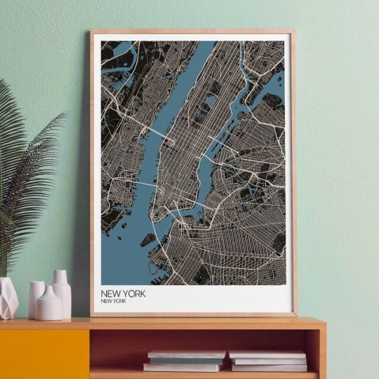
New York! Get a slice of the big apple on your wall with this Map Art Print by @mapplyco Click the 👜 to buy now. Various Size Options • 3 Paper Choices • Worldwide Delivery #map #citymap #citymapart #cities #maps #graphicmaps #artprints #mapprints #usa #uk #south #newyork #newyorkmap #stylishmap #mapdrawing #mapart #wallart #contemporaryart #contemporaryprints #digitalprints #homedecor #wallartprint #citymaps #artwork #designprints #art #graphicdesign #vectormap #cartography (at Manchester, United Kingdom) https://www.instagram.com/p/Bxdc9honkDJ/?utm_source=ig_tumblr_share&igshid=fer0hbpg1d6x
#map#citymap#citymapart#cities#maps#graphicmaps#artprints#mapprints#usa#uk#south#newyork#newyorkmap#stylishmap#mapdrawing#mapart#wallart#contemporaryart#contemporaryprints#digitalprints#homedecor#wallartprint#citymaps#artwork#designprints#art#graphicdesign#vectormap#cartography
0 notes
Photo

My current WIP. Working on #procedural materials transitioning states using animated gradients. Oh, and fire. #tfd #turbulencefd #vectormaps #cinema4d #dailyrender #dailydesign #3d #3ddesign
0 notes
Text
@geoinquiets: RT @ibesora: A data-driven journey through Vector Tile optimization #VectorTiles #VectorMaps #mapbox #GIS https://t.co/A9Por8Tyir
from http://twitter.com/geoinquiets via IFTTT
0 notes
Photo

Karlsruhe [.PDF] Map, Germany. Printable and Editable City Plan of Karlsruhe, 💚[Adobe PDF]💚 💚Scalable, text format of street names [51 Mb PDF .ZIP]. 💚Da follow Our Instagram for more maps: @gps.dominicana ▶SUNDAY SPECIAL for #Germany People! 🔥Grab your Karlsruhe PDF Map [.ZIP, PDF: 51 Mb] Buy↓↓↓🍑 https://ift.tt/2JsgQao For High Quality Printing. Layered Adobe PDF map of Karlsruhe. [DE] Karlsruhe [.PDF] Karte, Deutschland. Druckbarer und bearbeitbarer Stadtplan von Karlsruhe, 💚 [Adobe PDF] 💚 Skalierbar, Textformat von Straßennamen [51 Mb PDF .ZIP]. #Karlsruhe #stadtplan #karte #cityplan #germanymaps #germany #deutschland #straßenkarte #pdfmaps #map #pdf #vectormap #maps #illustrator #vector #printable #adobe #scalable #editable #druckbar #skalierbar #editierbar — view on Instagram https://ift.tt/2LFbBkl
0 notes
Text
The Case for Sharing All of America's Data on Mosquitoes
For decades, agencies around the United States have been collecting data on mosquitoes. Biologists set traps, dissect captured insects, and identify which species they belong to. They’ve done this for millions of mosquitoes, creating an unprecedented trove of information—easily one of the biggest long-term attempts to monitor any group of animals, if not the very biggest.
The problem, according to Micaela Elvira Martinez from Princeton University and Samuel Rund from the University of Notre Dame, is that this treasure trove of data isn’t all in the same place, and only a small fraction of it is public. The rest is inaccessible, hoarded by local mosquito-control agencies around the country.
Currently, these agencies can use their data to check if their attempts to curtail mosquito populations are working. Are they doing enough to remove stagnant water, for example? Do they need to spray pesticides? But if they shared their findings, Martinez and Rund say that scientists could do much more. They could better understand the ecology of these insects, predict the spread of mosquito-borne diseases like dengue fever or Zika, coordinate control efforts across states and counties, and quickly spot the arrival of new invasive species.
That’s why Martinez and Rund are now calling for the creation of a national database of mosquito records that anyone can access. “There’s a huge amount of taxpayer investment and human effort that goes into setting traps, checking them weekly, dissecting all those mosquitoes under a microscope, and tabulating the data,” says Martinez. “It would be a big bang for our buck to collate all that data and make it available.”
Martinez is a disease modeler—someone who uses real-world data to build simulations that reveal how infections rise, spread, and fall. She typically works with childhood diseases like measles and polio, where researchers are almost spoiled for data. Physicians are legally bound to report any cases, and the Centers for Disease Control and Prevention (CDC) compiles and publishes this information as a weekly report.
The same applies to cases of mosquito-borne diseases like dengue and Zika, but not to populations of the insects themselves. So, during last year’s Zika epidemic, when Martinez wanted to study the Aedes aegypti mosquito that spreads the disease, she had a tough time. “I was really surprised that I couldn’t find data on Aedes aegypti numbers,” she says. Her colleagues explained that scientists use climate variables like temperature and humidity to predict where mosquitoes are going to be abundant. That seemed ludicrous to her, especially since organizations collect information on the actual insects. It’s just that no one ever gathers those figures together.
Together with Rund and a team of undergraduate students, she found that there are more than 1,000 separate agencies in the United States that collect mosquito data—at least one in every county or jurisdiction. Only 152 agencies make their data publicly available in some way. The team collated everything they could find since 2009, and ended up with information about more than 15 million mosquitoes. Imagine what they’d have if all the datasets were open, especially since some go back decades.
A few mosquito-related databases do exist, but none are quite right. ArboNET, which is managed by the CDC and state health departments, mainly stores data about mosquito-borne diseases, and whatever information it has on the insects themselves isn’t precise enough in either time or space to be useful for modeling. MosquitoNET, which was developed by the CDC, does track mosquitoes, but “it’s a completely closed system, and hardly anyone has access to it,” says Rund. The Smithsonian Institution’s VectorMap is better in that it’s accessible, “but it lacks any real-time data from the continental United States,” says Rund. “When I checked a few months ago, it had just one record of Aedes aegypti since 2013.”
“That’s why we came up with this idea of a national surveillance system,” Martinez says. “The U.S. government should make it a requirement for mosquito-control boards to send in their data.”
Some scientists who work on mosquito control apparently disagree, and negative reviews have stopped Martinez and Rund from publishing their ideas in prominent academic journals. (For now, they’ve uploaded a paper describing their vision to the preprint repository bioRxiv.) “Some control boards say: What if people want to sue us because we’re showing that they have mosquito vectors near their homes, or if their house prices go down?” says Martinez. “And one mosquito-control scientist told me that no one should be able to work with mosquito data unless they’ve gone out and trapped mosquitoes themselves.”
Other scientists aren’t convinced that collating the data would be useful. “To predict an outbreak, a national database would be of no use,” says Lyle Petersen, who directs the CDC’s Division of Vector-Borne Diseases. “Mosquito density is very, very local. Knowing what’s going on with mosquitoes in California isn’t going to help you with what’s going on in Illinois. The data from even one part of a city may be totally irrelevant to another.”
Micah Hahn, an epidemiologist at the University of Alaska Anchorage, feels differently. She says that a national mosquito database “would be extremely useful for public health-planning and emergency response”—but creating one would be a logistical nightmare.
“There are hundreds to thousands of independently operating vector-control units—some not more than a guy and truck in rural areas—with varying levels of human resources and computer savvy,” she says. They vary in which traps and baits they use, whether they count males as well as females, and whether they identify insects down to the species or genus. Merging such disparate data would be hard, and there’s no quality-control system in place for checking it.
Roxanne Connelly, an entomologist at the University of Florida, agrees. “As a researcher, I’d love to have access to a nation-wide mosquito surveillance database and have often wished for such a system in Florida,” she says. But after 17 years of experience, she thinks that “trying to standardize the data, for the past or in for future, is going to be almost impossible.”
Martinez agrees that this is the biggest obstacle to creating the database of her dreams—but she doesn’t see it as a deal-breaker. She and Rund argue that many states have already taken steps toward building open databases. Iowa, for example, makes all its mosquito data freely available. “At a minimum we are advocating for stringing these systems together,” they say.
“Data should be made available without having to justify exactly what’s going to be done with it,” Martinez says. “We should put it out there for scientists to start unlocking it. I think there are a ton of biologists who will come up with cool things to do.”
from Health News And Updates https://www.theatlantic.com/science/archive/2017/08/mosquito-data/537735/?utm_source=feed
0 notes
Text
The Case for Sharing All of America's Data on Mosquitoes
For decades, agencies around the United States have been collecting data on mosquitoes. Biologists set traps, dissect captured insects, and identify which species they belong to. They’ve done this for millions of mosquitoes, creating an unprecedented trove of information—easily one of the biggest long-term attempts to monitor any group of animals, if not the very biggest.
The problem, according to Micaela Elvira Martinez from Princeton University and Samuel Rund from the University of Notre Dame, is that this treasure trove of data isn’t all in the same place, and only a small fraction of it is public. The rest is inaccessible, hoarded by local mosquito-control agencies around the country.
Currently, these agencies can use their data to check if their attempts to curtail mosquito populations are working. Are they doing enough to remove stagnant water, for example? Do they need to spray pesticides? But if they shared their findings, Martinez and Rund say that scientists could do much more. They could better understand the ecology of these insects, predict the spread of mosquito-borne diseases like dengue fever or Zika, coordinate control efforts across states and counties, and quickly spot the arrival of new invasive species.
That’s why Martinez and Rund are now calling for the creation of a national database of mosquito records that anyone can access. “There’s a huge amount of taxpayer investment and human effort that goes into setting traps, checking them weekly, dissecting all those mosquitoes under a microscope, and tabulating the data,” says Martinez. “It would be a big bang for our buck to collate all that data and make it available.”
Martinez is a disease modeler—someone who uses real-world data to build simulations that reveal how infections rise, spread, and fall. She typically works with childhood diseases like measles and polio, where researchers are almost spoiled for data. Physicians are legally bound to report any cases, and the Centers for Disease Control and Prevention (CDC) compiles and publishes this information as a weekly report.
The same applies to cases of mosquito-borne diseases like dengue and Zika, but not to populations of the insects themselves. So, during last year’s Zika epidemic, when Martinez wanted to study the Aedes aegypti mosquito that spreads the disease, she had a tough time. “I was really surprised that I couldn’t find data on Aedes aegypti numbers,” she says. Her colleagues explained that scientists use climate variables like temperature and humidity to predict where mosquitoes are going to be abundant. That seemed ludicrous to her, especially since organizations collect information on the actual insects. It’s just that no one ever gathers those figures together.
Together with Rund and a team of undergraduate students, she found that there are more than 1,000 separate agencies in the United States that collect mosquito data—at least one in every county or jurisdiction. Only 152 agencies make their data publicly available in some way. The team collated everything they could find since 2009, and ended up with information about more than 15 million mosquitoes. Imagine what they’d have if all the datasets were open, especially since some go back decades.
A few mosquito-related databases do exist, but none are quite right. ArboNET, which is managed by the CDC and state health departments, mainly stores data about mosquito-borne diseases, and whatever information it has on the insects themselves isn’t precise enough in either time or space to be useful for modeling. MosquitoNET, which was developed by the CDC, does track mosquitoes, but “it’s a completely closed system, and hardly anyone has access to it,” says Rund. The Smithsonian Institution’s VectorMap is better in that it’s accessible, “but it lacks any real-time data from the continental United States,” says Rund. “When I checked a few months ago, it had just one record of Aedes aegypti since 2013.”
“That’s why we came up with this idea of a national surveillance system,” Martinez says. “The U.S. government should make it a requirement for mosquito-control boards to send in their data.”
Some scientists who work on mosquito control apparently disagree, and negative reviews have stopped Martinez and Rund from publishing their ideas in prominent academic journals. (For now, they’ve uploaded a paper describing their vision to the preprint repository bioRxiv.) “Some control boards say: What if people want to sue us because we’re showing that they have mosquito vectors near their homes, or if their house prices go down?” says Martinez. “And one mosquito-control scientist told me that no one should be able to work with mosquito data unless they’ve gone out and trapped mosquitoes themselves.”
Other scientists aren’t convinced that collating the data would be useful. “To predict an outbreak, a national database would be of no use,” says Lyle Petersen, who directs the CDC’s Division of Vector-Borne Diseases. “Mosquito density is very, very local. Knowing what’s going on with mosquitoes in California isn’t going to help you with what’s going on in Illinois. The data from even one part of a city may be totally irrelevant to another.”
Micah Hahn, an epidemiologist at the University of Alaska Anchorage, feels differently. She says that a national mosquito database “would be extremely useful for public health-planning and emergency response”—but creating one would be a logistical nightmare.
“There are hundreds to thousands of independently operating vector-control units—some not more than a guy and truck in rural areas—with varying levels of human resources and computer savvy,” she says. They vary in which traps and baits they use, whether they count males as well as females, and whether they identify insects down to the species or genus. Merging such disparate data would be hard, and there’s no quality-control system in place for checking it.
Roxanne Connelly, an entomologist at the University of Florida, agrees. “As a researcher, I’d love to have access to a nation-wide mosquito surveillance database and have often wished for such a system in Florida,” she says. But after 17 years of experience, she thinks that “trying to standardize the data, for the past or in for future, is going to be almost impossible.”
Martinez agrees that this is the biggest obstacle to creating the database of her dreams—but she doesn’t see it as a deal-breaker. She and Rund argue that many states have already taken steps toward building open databases. Iowa, for example, makes all its mosquito data freely available. “At a minimum we are advocating for stringing these systems together,” they say.
“Data should be made available without having to justify exactly what’s going to be done with it,” Martinez says. “We should put it out there for scientists to start unlocking it. I think there are a ton of biologists who will come up with cool things to do.”
Article source here:The Atlantic
0 notes
Photo

Netherlands PDF Admin Map Printable Vector 01 exact Mercator Projection, editable Layered Adobe PDF
https://vectormap.info/product/netherlands-pdf-admin-map-printable-vector-01-exact-mercator-projection-editable-layered-adobe-pdf/
#map #vectormap #printablemap #print #printing #pdfmap #illustrator #art #design #designer #vector #graphics #editablemap #cityplan #citiplan #citymap #citimap #streetmap
0 notes
Photo

Map of Virginia. #vectorart, #vectormap, #virginiainfographics, #monticello,#mountvernon,#moountvernonva
0 notes