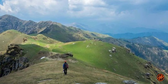
#winter trek india
Text
The moment having India Flag in hands at such places makes me proud on myself always.
.........
#india #IndianFlag #ILiveMyIndia #Kedarkanta #Trekking #KedarkanthaVlog #TravelIndia #IndianVlogger #RidingYogi #LucknowTravelVlogger #KedarkanthaPeak #TreakIndia #Uttarakhand
#indian biker#I love my india#indian flag#kedarkantha summit#uttarakhand#explore india#indian travel vlogger#lucknow travel vlogger#adventure trip#winter trek india#best indian trek#Lucknow biker riding yogi#indian biker riding yogi#himalaya trek
2 notes
·
View notes
Text

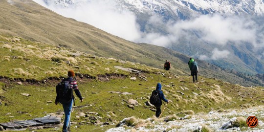
Friendship Peak Expedition, Manali - HIMTREK
Friendship Peak Expedition is a renowned trekking peak located in the Pir Panjal range of the Indian Himalayas in Himachal Pradesh. The trek derives its name from the Friendship Treaty between India and Pakistan in the 1950s. It offers a thrilling opportunity for both experienced and novice trekkers to test their limits and experience high altitude trekking. The trek is a 6N/7D journey that takes you through beautiful alpine meadows, dense forests, and rugged terrain, providing spectacular views of the surrounding peaks. Starting from the popular tourist destination of Manali, the trek offers stunning vistas of the Dhauladhar and Pir Panjal ranges, guaranteed to leave trekkers spellbound. Friendship Peak Trek offered by HimTrek is a captivating adventure nestled in the majestic Himalayas. This trek presents a perfect blend of breathtaking landscapes, challenging terrains, and the warmth of camaraderie among fellow trekkers. The journey begins with a thrilling drive from Manali, taking you through picturesque valleys and quaint villages. The climb to the summit of Friendship Peak involves navigating steep rocky slopes, narrow ridges, and a glacier. Hence, prior experience in high altitude trekking is necessary. However, the summit offers a rewarding 360-degree panoramic view of the surrounding mountain ranges and valleys.
#travel#food#veiw#new place#hiking#camping#mountains#snowtrekking#camping and trekking#best treks in winter#trekking#trekking in india#best treks in india#vacations#cheap vacation packages#travel packages#best holiday packages#best tour packages#best trekking in india#nature#travelphotography#photography#summer#explore#trip#vacation#follow#traveling#happy#fashion
0 notes
Text
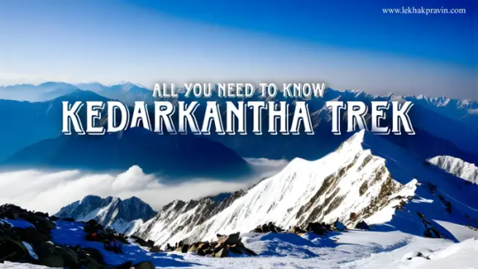
The Queen of Winter Treks - Kedarkantha Trek - Complete Trekking Guide for 2024, Itinerary, Budget and Best Experience
When it comes to Indian Winter Treks, Kedarkantha is always the table topper. Kedarkantha Trek is often termed as “The Queen Of Winter Treks” being one of the most popular choices amongst the trekkers. It is definitely a great trek for beginners too. Kedarkantha Trek offers some of the best campsites and summit experiences. The trail of Kedarkantha is, thus, a very special one indeed.
Basic…
View On WordPress
#best trek in india#best winter trek#delhi to dehradun distance#flights from mumbai to dehradun#how to reach kedarkantha#kedarkantha height in feet#kedarkantha trek#kedarkantha trek 2024#kedarkantha trek distance#kedarkantha trek location#kedarkantha winter trek#train from delhi to dehradun
0 notes
Text
Kuaripass Winter Trek : Scenic Wonders
What is Kuaripass Winter Trek?

Exploring the Himalayan Gem
Kuaripass Winter Trek is a remarkable journey through the Garhwal region of Uttarakhand, India. This trek is renowned for its snow-covered landscapes, making it a haven for adventure enthusiasts and nature lovers alike. The trek takes its name from the Kuaripass, a high-altitude mountain pass located at an elevation of approximately 12,516 feet (3,815 meters) above sea level.
Seasonal Marvel
This kuaripass trek is best experienced during the winter months, from December to February, when the entire region is blanketed in snow. The snow-laden trails add a magical touch to the journey, transforming it into a winter wonderland.
Getting There and Preparation
Starting Point: Joshimath
The Kuaripass Winter Trek typically begins from Joshimath, a picturesque town nestled in the Garhwal Himalayas. You can reach Joshimath by road from the major cities of Dehradun or Rishikesh.
Permits and Essentials
Before embarking on this adventure, it’s essential to obtain the necessary permits from the Forest Department. Additionally, ensure you have the right gear, including warm clothing, sturdy boots, and a reliable backpack.
The Winter Kuaripass Trekking Itinerary
Day 1: Joshimath to Dhak Village
Your journey begins with a scenic drive from Joshimath to Dhak Village. This will be your first encounter with the snow-clad landscapes of the region.
Day 2: Dhak Village to Guling Camp
On the second day, you’ll trek from Dhak Village to Guling Camp, passing through dense forests and meadows adorned with snow.
Day 3: Guling Camp to Kuaripass
The highlight of the trek, Day 3, takes you from Guling Camp to Kuaripass. The breathtaking views from the pass are unparalleled, and you’ll feel on top of the world.
Day 4: Kuaripass to Tali
Descending from Kuaripass, you’ll head to the serene Tali Lake, surrounded by towering peaks.
Day 5: Tali to Joshimath
The final leg of the journey brings you back to Joshimath, where you can reflect on the incredible adventure you’ve just experienced.
Flora and Fauna
Witnessing Wildlife
While trekking through the Garhwal region, keep an eye out for the diverse wildlife, including Himalayan Monal, snow leopards, and musk deer. The region’s biodiversity is truly remarkable.
Safety Measures
Staying Safe in the Snow
Trekking in winter conditions requires careful planning and precautions. Ensure you have a knowledgeable guide with you, and stay updated on weather forecasts.
The Beauty of Solitude
Disconnecting from the World
One of the most remarkable aspects of the Kuaripass Winter Trek is the opportunity to disconnect from the hustle and bustle of daily life. The serene landscapes and quietude of the mountains offer a sense of peace and tranquility like no other.
Conclusion: Kuaripass Winter Trek
The Kuaripass Winter Trek is a remarkable journey that will leave you spellbound. From the pristine snowscapes to the majestic mountains and unique wildlife, this adventure is an absolute must for those seeking an unforgettable experience in the Himalayas.
Visit us to know more about trekking in himalaya - Transhimalaya
#Kuaripass Winter Trek#Winter Trek Kuaripass#snow trek india#trekking in himalayas#best trekking sites in india
0 notes
Text
#Best trekking places in India for beginners#Best trekking sites for adventure lovers#Best treks in India#Top 9 trekking places in India#Most difficult treks in India#Most popular himalayan treks in India#Best monsoon treks in India#Best winter trek in India#Most famous summer trek#Best trekking places in Uttrakhand
0 notes
Text
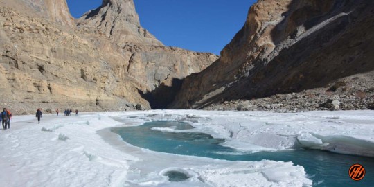
Chadar Trek In Leh – over the Zanskar River range of Ladakh
Your trek journey started with Himalayan Hikers, the beautiful mountain town of Leh, all our trekkers reach Leh by flight this is the best option for your reach to Leh, altitude is 11400 feet above sea level, and the trek beautiful Zanskar River which liws totally frozen during the December to Feb, Peak Winters Trek, So, probably the best time to do Chadar Trek is February because the ice remains harsh and stable. Trek starts from the freezing point of the Zanskar River and that is Chilling.
Therefore, the “Chadar trek” is also known as “The Frozen River Trek”. This Trek is over a frozen river in the Zanskar region of Ladakh and it is different from all other treks in the Himalayas.
Ice Covering and Freezing Cold in Chadar Trek
The Chadar trek is over a frozen river and the ice can turn dangerous sometimes but can also be safe the other times. But, it is important to find a safe path over the perilous sheet of ice.
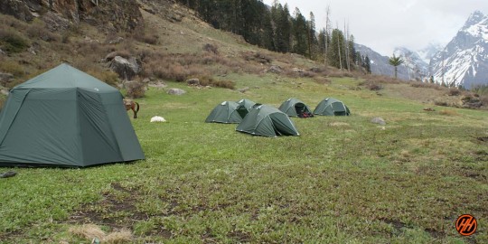
During the trek, you do not camp here at the meadows or the forest clearings but inside the caves which are present along the banks or you set up the tents on stable ice.

Be Aware During Chadar Trek (Not for Beginners)
You need to be very aware of the stability of ice and conditions below the feet for a safe trek. Sometimes the ice isn’t stable and the choices go wrong so walk carefully if suddenly a crack appears to go fast to the place where the ice is
So, choose a camping spot wisely after properly analyzing the area.
Here are some tips to do Chadar Trek –
Analyze the ice sheet conditions.
Avoid the cracks in the ice.
Walk carefully on slippery areas.
Run immediately to a stable area if a sudden crack appears under your feet.
Walk on the places with a coating of snow.
Choose camping spots wisely.
Alcohol and smoking are not allowed during the trek
Level- Difficult
During the trek, proper conditioning & training of the body required
Need proper gear & clothing for sub-zero temperature
Shoes are the single most important piece of equipment.
High Altitude requires proper acclimatization. Of base camp Leh
Beautiful landscapes so carry good photo gear & Extra battery backup.
Travel headlight
The backpack should not exceed 12 kg.
Long Gumboots are mandatory for all trekkers
Also Read About – Chaainsheel Bugyal Trek – The most beautiful ridge trek
About Leh – Ladakh – The Land of High Passes
Area: 98,000sq km
Altitude: 7,500m Max.
Population: 250,000
Religion: Buddhism, Islam. Hindu
Geographical Status: Cold Desert
Across the Kashmir Valley and over the famous Zoji La pass lies Ladakh, the Land of High Passes. It is a magical land, so completely different from the green landscape of some other parts of the Himalayas. It is nature at its extreme. A land of freezing winds and blazing sunlight, Ladakh is a cold desert lying in the rain shadow of the Great Himalayas and other smaller ranges. Little rain and snow reach this dry area, where the natural forces have created a fantastic landscape.
Ladakh forms part of the state of Jammu and Kashmir in India. Parts of Ladakh are under the illegal occupation of Pakistan and China. The border of Ladakh touches those of Afghanistan, Pakistan, China, the Kashmir Valley (India), and Himachal Pradesh (India). This region is made up of two administrative districts — Leh District, with its headquarters at Leh, and Kargil District, with its headquarters at Kargil –and covers a total area of about 59,000 square kilometers.
Ladakh is at an average elevation of 2,700 m to 4,200 m. The aridity of this region is due to its location in the rainshadow area of the Great Himalayas, elevation, and radiation of heat from the bare soil. The most striking physical feature of Ladakh, however, is the parallelism of its mountain ranges. The region is extremely dry, with annual rainfall as low as 10 cubic centimeters.
In Ladakh, large rivers and their tributaries have carved deep gorges far below their steep banks. However, their water is not of much use as the terraced fields lie high above the gorges.

The altitude we are going to cover in Chadar Trek
Leh – 3500 Meters
Tsomo Paldar camp – 3200 Meters
Tibb Cave camp – 3300 Meters
Nerak camp – 3400 meters
ATM Point & Mobile connectivity in Chadar Trek
ATM POINT: Hi trekker ATM available in Leh Withdraw money before your journey,
Mobile Connectivity: There will be available all networks only postpaid
Key Points of Chadar Trek
Duration: – 8 Nights 9 Days from Leh to Leh
Base camp: – Leh
Winter Temperature:- Day -5°C to -15°C) Night – 12° C to -20° C
Chadar trek – Altitude: – 11400 feet
Best Time: – Jan or Feb
Trek Level: – Difficult
Trek distance: – On foot 57 Km – By taxi 140 km
Group Size: – minimum of 5 people maximum of 15 people
Temperature
The winter temp. touches as low as minus 30 degrees (Leh & Kargil) and minus 60 degrees in (Drass) subzero temp. prevails from December to February throughout Ladakh, whereas, zero-degree temp. is experienced during the rest of the winter months. This results in the freezing of all conceivable water resources. During summers the maximum temp. increases from 20 degrees C to 38 degrees C in July and August

Languages Spoken
Ladakhi is the main language of Ladakh. Other languages spoken are Balti, Shina, Brokshat, and Changsha. In hotels and restaurants, staffs speak English and Hindi, while tour guides are well-versed in the language.
Key Points about Chadar Trek
– Level: Difficult (so first-timers trekkers should avoid)
– Proper conditioning & training of the body required
– Group size minimum of 05 and a maximum of 15 people
– Need proper Expedition gear & clothing for sub-zero temperatures?
– Shoes are the single most important equipment
– High Altitude requires proper acclimatization
– Phones don’t work on the trek, we provide to you Radio Walkie Talkie for Communication
– Beautiful landscape so carry good photo gear (I couldn’t carry my best equipment)
– Travel light (my backpack was heavy at about 12 kg to 15 Kg )
– Keep an extra day in your itinerary for attempt to Chadar trek summit account for bad weather
– Alcohol and smoking is not allowed in during the Chadar Trek Expedition
Difficulty level
Because the top is relatively high in elevation, we strongly recommend a reasonable level of physical fitness. The arduous journey of Chadar trek winter hiking with longer distances and ascending elevations to be covered in a short span of time would require acclimatization. We advise trekkers to physically and mentally prepare themselves prior to this trek. Throughout the course, all groups will be guided by our experts for trekking equipment and any impending terrain.
Any medical assistance that is required will be provided at any point of the journey; however, trekkers must consult their professional care before beginning any trek. We also strongly advise trekkers to learn about altitude sickness and to notify our teams as soon as any symptoms appear.
Short Itinerary of Chadar Trek
Day 1:- Arrival at Leh – pickup to you from Airport drive to Hotel check in Rest and Acclimatization overnight stay Hotel
Day 2:- Trek Planning and Briefing – Acclimatization and Preparation- meet us our Himalayan Hikers Guide overnight stay
Day 3:- Medical Test Day in Leh
Day 4:- Drive from Leh to Bakula (70 km) (2 hours) same Day Trek Bakula to Shingra Koma 2/3 Hours overnight stay Camp
Day 5:- Trek from Shingra Koma to Tibba (16 km) (6/7 Hours) overnight stay Camp
Day 6:- Trek from Tibba to Nerak Waterfall (12 km )( 6/7 Hours) overnight stay Camp
Day 7:- Trek from Nerak to Tibba (16km ) (6/7 hours) overnight stay Camp
Day 8:- Trek from Tibba to Bakula (12 km) (6/7 hours) Same day Drive to Leh Hotel
Day 9:- After breakfast Depart from Leh
Permit and Passport
Tourist don’t require permit for Leh, however, all foreigners are required to be registered at Drass, Rumtse and Serchu if they are travelling overland. Those traveling by air get themselves registered at airport. Tourists are required to get permit for restricted areas like Tsomoriri, Tsokar and Pangong Lakes, Dhahanu and Nubra Valley, which can be obtained from District Magistrate, Leh, through Travel Agents at Leh.
Avoid acute mountain sickness
Acute mountain sickness can occur to any one at an altitude above 10,000 ft. above sea level, therefore, make it sure to take complete rest on the day of arrival.
How to Reach Leh or ladakh
Overland Approach
Overland Approach – The overland approach to Ladakh from Kashmir Valley via Kargil is approx. 434 Km, which remains open for traffic from early June to November. The most dramatic part of this road journey is the ascent up the 11,500 feet / 3,505 m high Zoji-La, the pass in the Great Himalayan Wall that serves as the gateway to Ladakh. The J & K State Road Transport Corporation (J&K SRTC) operates regular Deluxe and Ordinary bus services between Srinagar and Leh on this route with an overnight halt at Kargil. Taxis (cars and jeeps) are also available at Srinagar for the journey. Groups can charter Deluxe and A-class buses for Leh, Kargil or Padum (Zangskar) from the J & K SRTC at Srinagar.
Manali to Leh – Since 1989, the 473 km. Manali-Leh road has been serving as the second overland approach to Ladakh. Open for traffic from around mid-June to early October. This high road traverses the upland desert plateau of Rupsho, altitude ranges from 3,660m to 4,570m. A number of high passes fall enroute among which the highest one known as Taklang-La is world’s second highest motorable pass at an altitude of 17,469 feet/5,235m. Himachal Pradesh Tourism, HRTC and J & K SRTC operate daily Deluxe and Ordinary bus services between Manali and Leh. The bus journey between Leh and Manali takes about 19 hours or two days with an overnight halt in camps at Serchu or Pang. Shared taxis are also available both from Leh and Manali
Road Distances
Srinagar-Leh 434 Km
Manali-Leh 473 Km
Srinagar-Kargil 204 Km
Delhi-Leh 1047 Kms
Leh-Kargil 234 Km
Kargil-Padum (Zanskar) 240 Km
Leh-Deskit (Nubra Valley)118 Kms.
Credit Cards & ATM Machine
Credit cards are accepted by very few hotels and tour operators but there will be 2.5% service charge. The Jammu and Kashmir Bank and State Bank of India has placed ATM Machine in Leh. The State Bank of India accepts visa and mastero but this ATM is not very reliable. J&K Bank ATM is more reliable but accepts only Mastero.
Air Travel
Indian Airlines http://www.indian-airlines.nic.in operates regular flights to Leh from Delhi (fare USD 135), Four flights in a week from Jammu and once in a week from Chandigarh and twice from Srinagar. Jet Airways http://www.jetairways.com also operates daily flights between Leh-Delhi (fare USD 143).
Internal Transport
The cheapest way to travel within the region is by public buses, which ply on fixed routes according to fixed time schedules. The most comfortable and convenient though expensive mode of travel, however, is by taxi, which are available for hire on fixed point-to-point tariff. For visits to the newly opened areas of Nubra, Dah-Hanu, Tsomoriri, Tsokar and Pangong Lakes. It is mandatory to engage the services of a registered/recognized travel agency for making all the requisite arrangements including internal transport. Detailed information about bus schedules, taxi tariff, travel agencies can be obtained from the Tourist Office or Local travels guide “Reach Ladakh”, available at Book Shops.
Leh is the headquarter of Leh District, and the largest town of the region. It is located to the north of the Indus River at an elevation of 3600m above the sea level. The town is dominated by the nine-storey Namgyal Palace and Namgyal Tsemo (victory peak), built by Tashi Namgyal on his victorious in reunification of the Upper and Lower Ladakh. Leh became the capital of Stod (upper Ladakh) during the reign of king Graspa Bum- Lde,who ruled Ladakh from 1400 to 1430 AD. In the later period, Leh became an important center for trade in Central Asia. Leh remained merely a headquarter of Ladakh district until 1974, when Ladakh was opened for foreign tourists. Since then period Leh became the centre for tourism related activities in the region.
Fact File
Leh provides medium and lower class accommodation, with hundreds of guesthouses and hotels, which can suite every budget. Restaurants offer good multicuisine for a reasonable price. There are number of tour Operator/Travel Agents around the town, which look after traveler’s requirements.
Tour of Buddhist monasteries can be organised in one or two days, as all the famous monasteries are within a drive of one or two days from Leh. For information on monasteries please check monastery section of this web site.
0 notes
Text
The top 5 most stunning winter treks in India for lovers of snow

The difficulty level is dramatically raised in environments with higher altitudes and lower temperatures. It's a one-of-a-kind wilderness excursion that offers stunning vistas of high mountain peaks blanketed in beautiful white snow. Here are a few of the most stunning winter treks in India for those with adventurous hearts who want to see scenery filled with exotic meadows, enchanted oak woods, refreshing and magnificent waterfalls, lakes, secluded villages, and more.
0 notes
Link
Looking for some amazing new adventure hiking places in India? Some offbeat yet unexplored treks in India would win your heart.
0 notes
Photo

Are you ready for winter trek ? . . BOOKINGS OPEN . . 📞 Trek Expert: 79 0202 2121 . . #travelchapes #chapesforever . . . #trekking #kedarkantha #brahmataltrek #treks #winter #india #trekkingindia (at Mumbai, Maharashtra) https://www.instagram.com/p/CiABSL8JJh2/?igshid=NGJjMDIxMWI=
0 notes
Text
Best Winter Treks to do in India
Best Winter Treks to do in India
While monsoon walks and other seasons like Summer tend to receive all the limelight, there is something indescribably amazing about the crunch of snow beneath your feet.
It is a magnificent experience to wake up to vast expanses of all-white landscapes that stretch as far as the eye can see after sleeping beneath some of the clearest sky of the year. The best thing about winter excursions,…

View On WordPress
0 notes
Text
Hitting to Sankari village - The village from where Kedarkantha Trek starts

#Kedarkantha#indian travel vlogger#riding yogi#travel videos#adventure#lucknow travel vlogger#yogi baba#travel blog#travel photography#uttarakhand#indian biker#Kedarkantha trek#winter trek india#moderate trek in india#himalayan#bike life#Royal Enfield Himalayan#Kedarkantha on bike
1 note
·
View note
Text

Treks in Himachal Pradesh
Sar Pass Trek
Embark on the Sar Pass Trek, one of the best trekking experiences in India, offered by Himtrek. Discover the breathtaking beauty of the Himalayas as you trek through the Parvati Valley in Himachal Pradesh. With our best tour packages, you'll enjoy a seamless and unforgettable adventure.
Begin your journey with a thrilling trek through dense forests and pristine meadows, encountering vibrant flora and fauna along the way. Himtrek offers the best trekking and camping packages, allowing you to experience the magic of the mountains firsthand. Whether you're a seasoned trekker or a beginner, there's something for everyone on the Sar Pass Trek.
Camp under the starlit sky at Himtrek Riverside Camps Kasol, nestled amidst the serene surroundings of the Parvati Valley. Explore nearby attractions such as Manali Trek and camping in Kasol, adding more excitement to your adventure. Join us for an unforgettable experience filled with adventure, exploration, and camaraderie. Book your Sar Pass Trek package with Himtrek today!
For more information visit here: https://himtrek.co.in/
#mountains#veiw#food#new place#travel#snowtrekking#camping and trekking#best treks in winter#trekking#camping#hiking#trekking in india#best treks in india#vacations#cheap vacation packages#travel packages#best holiday packages#best tour packages#best trekking in india
0 notes
Link
Have a look on Top 8 Winter Treks of India like Kedarkantha Trek, Chadar, Sar Pass, Brahmatal and more. Explore Now!!
0 notes
Photo
Kuari Pass- Beautiful Winter Trek in Uttarakhand, Himalayas
Get upto 30% Early bird discount.
For more info related to Kuari Pass Winter Trekking Tour Call On : 📞 +91-8802149265
🌐 www.bontravelindia.com
#trek#trekking#winter trek#winter trekking#kuari pass#kuari pass trek#himalayas#winter trekking in himalayas#bon travel india
0 notes
Text
Complete Sandakphu Phalut Trek In Style With Himalayan Trek
For availing yourself of the best trekking packages, you should be 100% sure about joining hands with the finest trekking executives at Himalayan High. To book the best Sandakphu Phalut Trek package, reach the help desk now!

#sandakphu trekking#sandakphu phalut trek#sandakphu trek cost#sandakphu trek package#sandakphu trekking package#sandakphu winter trek#phalut trek#sandakphu phalut tour package#Adventure Trek Himalaya#Best Himalayan Trekking Groups#Best Trekking Company In India
0 notes
Text
Chaainsheel Bugyal Trek - The most beautiful ridge trek
Chaainsheel Bugyal is a high-altitude valley at a height of 11700 feet in the Uttarkashi district. Chaainsheel Bugyal lies on the border of Uttarakhand and Himachal Pradesh. This place is not known much by the trekkers and Uttarakhand Tourism declared it as “Trek of the Year” in 2017.
One of the least explored destinations, Chaainsheel valley has a number of surprising meadows and mesmerizing scenic views, it is a heaven in itself.
Chaainsheel Bugyal Trek lies at the Altitude of 11750 feet. The trek starts from Himari base camp which is the base camp of more than five treks
Chaainsheel Bugyal Valley hides exciting surprises
This is one of the destinations which is least explored, Chaainsheel valley has a number of surprising meadows and mesmerizing scenic views and it is less interrupted by the trekkers so this place can be compared to heaven or you can say it is heaven in itself. You will come across many breathtaking and captivating places in this valley.
The trail is through villages where you will get to see the culture and lifestyle of people living in the mountains. The lush green meadows are desired by the trekkers and there are a number of lakes present in this area, one thing which makes this trek amazing is camping in the middle of the meadows, the serene and refreshing climate, and crystal clear views of the Garhwal Himalayas in front. Walk along the Rupin River and Estari gad
While trekking along the Rupin River, the trail will take you through dense pine forests across ridges. In addition, the trails made it familiar with other famous treks.
Chaainsheel Bugyal Trek Great for Beginners
Beginners and experienced trekkers both can go for this trek as this varies from easy to moderate. This is a trek with inherent beauty which is in full bloom in the month of June.
Dynamic Sceneries of Chaainsheel Bugyal, Explore Two Valleys in One Trek
Moreover, you will get surprises on every bend of the trail. Hence, you will be delighted by the beauty of the Himalayas and God’s creation. Perhaps, exploring the two valleys in a single trek passing.
Why choose Chaainsheel Bugyal Trek?
Before heading towards the itinerary, it is really essential to perceive the reason behind choosing the Chaainsheel Bugyal trek.
See firstly, the trekking distance is a total of by taxi 420 Km and on foot 32 km which is to be covered in 8 days. Dehradun to via Mussoorie, Estari gad, Akhoti Thach, Gujjar hat, Chaainsheel Bugyal
Chaainsheel trek is a low-altitude mountain trek Altitudes is 11750 feet
The Starting trail is moderate as compared to other treks this is an easy and moderate trek. So this is the best option for first-time trekkers, families, and School
Need proper gear & clothing for sub-zero temperatures?
Also Read About – Borasu Pass Trek – The Ancient Trade Route in the Himalayas
You got to see so many heavenly bodies in one place like the panoramic view of the Himalayan ranges, you can see pine forests, different variety of flora and fauna surpassing through bona fide Garhwali heritage and culture.
I think Do spare time in Interaction with our local’s team, and you will get to know about some of the ancient tales of Indian mythology and our local cultures, this is good ideas for trekkers
Beautiful landscapes so carry proper photo gear & Extra battery backup.
The altitude we are going to cover in Chaainsheel Bugyal
Dehradun – 478 Meters
Himari camp – 5100 feet
Akhoti Thach – 8350 feet
Gujar hat – 9750 feet
Chaainsheel Bugyal – 11750 feet
Key Points Chaainsheel Bugyal trek
Duration: – 6 Nights 7 Days
Base camp: – Himari camp
Summer Temperature:- Day 5°C to 15°C) Night 5° C to 10° C
Chaainsheel Bugyal Altitude – 11750 feet
Best Time – May, June, September, October, November
Trek Level: – Moderate
Trek distance: – On foot 49 Km – By taxi 420 km
Group Size: – minimum 5 people maximum 15 people
Short Itinerary Chaainsheel Bugyal Trek
Day 1:Pickup to you from Dehradun railway station and drive to Himari camp (210 km) (8/9 Hours) (5100 feet)
Day 2:Trek from Himari camp via Estari gad to Akhoti Thach (12 km) (6/7 Hours) (8350 feet)
Day 3:Trek from Akhoti Thach to Gujar hat camp (04 km) (3/4 Hours) (9750 feet)
Day 4:Trek from Gujar hat to Chaainsheel Bugyal (06 km) (4/5 Hours) (11750 feet) Explore around Chaainsheel Bugyal
Day 5:Trek from Chaainsheel Bugyal to Akhoti Thach – (10 km) (5/6 Hours) (8350 feet)
Day 6:- Trek from Akhoti Thach to Himari champ (12km) (5/6 Hours) (5100 feet)
Day 7:Drive from Himari camp to Dehradun by taxi (210 km) (8/9 Hours)
#Chaainsheel Bugyal Trek#trekking in india#hiking#himalayan hikers#trekking in himachal pradesh#winter trek#himalayas
0 notes
Last Seen Blogs

chxshiya
𝒉𝒂𝒓𝒖♥︎シ︎

jun-playlist
jun.playlist

slowdancinginthecosmos-blog
I don't live here. I live in the cosmos.

thevoiding
Hellhound
myfiredetonation-blog
when the blog's lit