
the-syana-project
The Syana Project
a worldbuilding and conlang project set on a fictional group of large pacific islands.
17 posts
Don't wanna be here? Send us removal request.
Last Seen Blogs

anotheruserwithnoname
Work hard and be kind

potterstinks
Nice one, James

bupewoxitiq
Без названия

harris30874753-blog
Untitled

champouk
Paul Champion Change The Way You Think
Text
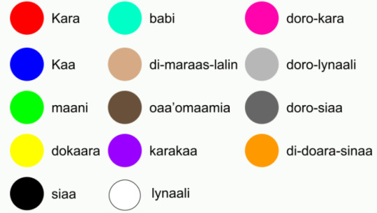
Updated KD travel map
Here's an updated (and much better imo) version of the Kaan-daal metro map including the metro lines, light rail and trams.
Heres a key since I couldn't fit one on the actual image:
Red = kara sisa (red route)
Yellow = dokaara sisa (yellow route)
Green = maani sisa (green route)
Blue = kaa sisa (blue route)
Pink = doro-kara sisa (pink route)
Orange = sisa di-doaro-sinaa (orange route)
Turquoise = babi sisa (turquoise route)
Grey = o'daram di-'maar (central trams)
Purple = kikokiko di-olasa (airport link / light rail)
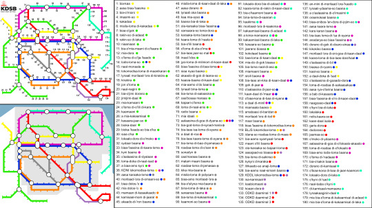
#conlang#worldbuilding#language#culture#world building#artwork#map#public transportation#public transit#metro
1 note
·
View note
Text
youtube
I started a youtube channel !!!
It's an entire channel dedicated to covering everything in the Syana Project in as much detail as I can, so prepare for some long asf videos
I'm also reviving this since I totally didn't forget I had a tumblr account whoopsies
1 note
·
View note
Text
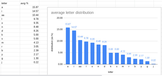
average letter distribution of Syan
here's a graph showing the average frequency that each letter appears as a percentage of all letters in a text.
#linguistics#conlang#data#languages#language#constructed language#world building#worldbuilding#phonetics
6 notes
·
View notes
Text
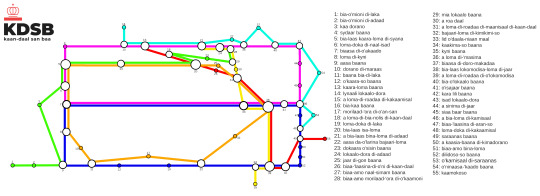
Kaan-daal Light rail Network
here is a diagram for the light rail services in the capital of Syana, as well as a list of the names of every stop on the network. (as well as a geographical map of the network)
the network is run by KDSB, who are the governmental agency in charge of all punlic transport in Kaan-daal.
1 note
·
View note
Text
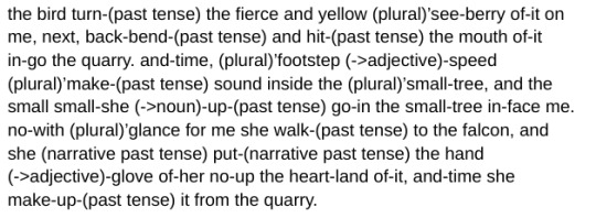
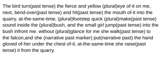
king in yellow translation
i translated a random paragraph from the book The King In Yellow. Below is what it would look like written down in syan as well as the paragraph i translated.
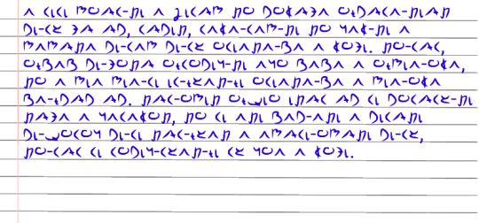
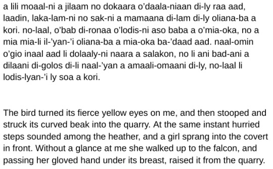
here are two glosses of the text, the first is a full morpheme breakdown, the second is a slightly easier to understand/read version.
#conlang#conlangs#worldbuilding#language#linguistics#world building#writing systems#languages#culture#constructed language#translation#translated literature
13 notes
·
View notes
Text
Syan currency
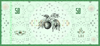
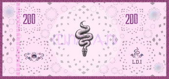
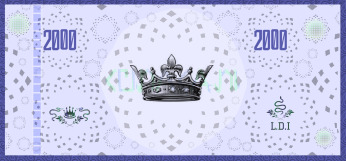
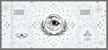
this is the syan curency, the isa. 200 o'isa is equivalent to round £1.00
below is a link to website page which contains more detail:
#conlang#worldbuilding#culture#language#world building#anthropology#artwork#writing systems#currency#art
4 notes
·
View notes
Text
Syan map timelapse
This is the process of me remaking the map of Syana, since the original was nearly 2 years old and needed updating.
0 notes
Text
Syan highway map
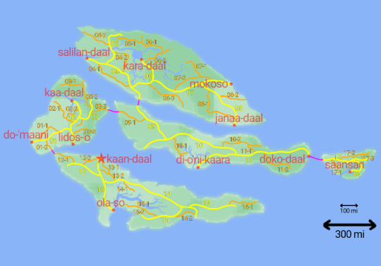
this map shows all of the o'biaa-baana (highways, shown in yellow) and the o'biaa-baana-isala (sub-highways, shown in orange). Both types of road have a speed limit of 80 km/h as well as 4 lanes in each direction. The pink lines show under-sea road tunnels that connect the islands' highway systems.
2 notes
·
View notes
Text
the Naal-'yan Mia Li region
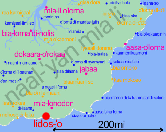
this is a map (in the syan + latin script) of the naal-'yan mia li region, which takes up the southeast section of Ilaana-maraas Island. This is the most popular area of Syana, outside of the capital, for tourists to visit and is also the region in which most Syan christians live, due to the country's only cathedral being found in the large town of Jabaa.
#worldbuilding#world building#conlang#maps#cartography#culture#language#writing systems#etymology#artwork#linguistics#anthropology#map#fictional geography
6 notes
·
View notes
Text
Syan colours
these are the names of the "main" colours in Syan. Blue and teal are entirely seperate colours, the same is the case with dark/light brown. Pink is seen as a variation of red, with dark and light grey seen as variations of black/white respectively (the syan word doro literally translates to "half").
0 notes
Text
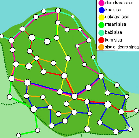
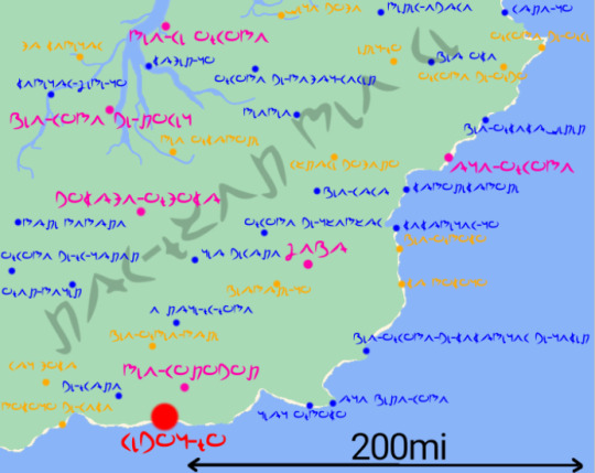
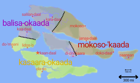
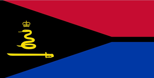
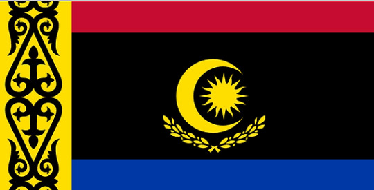
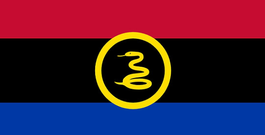
tribal nations
before colonisation and the rebellion leading to Syana as a nation being formed, the 5 islands were occupied by 3 tribal nations: the Kasaara nation (kasaara-okaada), the Balisa nation (balisa-okaada) and the Mokoso nation (mokoso-'kaada).
Here is the map showing the domains of these nations as well as their modern flags (used now as a historic source of pride).
4 notes
·
View notes
Text
previous/current national flags of Syana
These are all the iterations of the flag of Syana, from the founding of the modern nation in 1815 to the present day.
Linked is the website page that explains the origins/symbolism of the flag as well as having the flags of each of Syana's 5 islands.
4 notes
·
View notes
Text
The Syan Language (official textbook)
This is a link to the complete beginner's guide to learning the Syan language at a basic conversational level. The entire textbook can be read in around 15-20 minutes and is relatively simple due to Syan's easy-to-understand grammar and phonology.
2 notes
·
View notes
Text
syan numbers

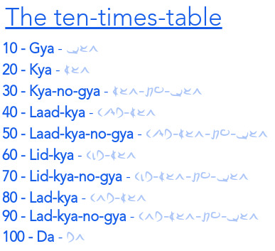
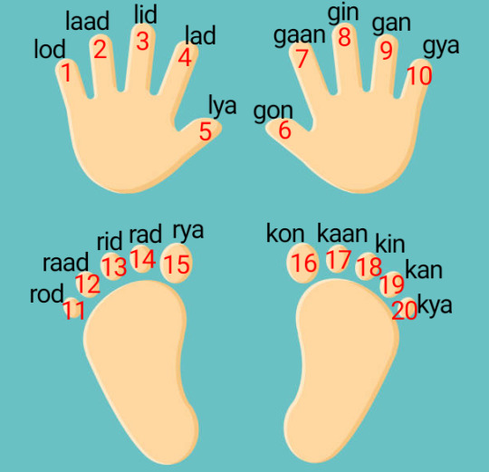
Syan has 20 unique digits that are the base for all numbers up to 100, this originates from each human digit being given a name and used to count.
In pre-colonial Syana, the word da (100) had the meaning "many" and was used to describe anything over 20.
5 notes
·
View notes
Text
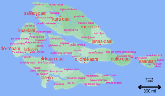
a map of Syana that shows tne size of the islands as well as every city (red locations) and every large town (pink locations).
large towns = places with other 100,000 permanent residents
cities = large towns with over 1 million residents
linked is the website page that goes into more detail about the official government definitions of population sizes.
0 notes
Text
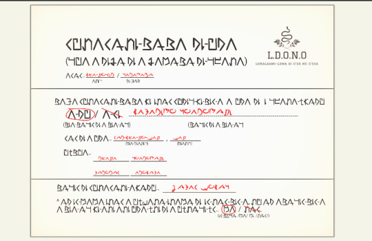
This is the script used for the Syan language, adapted from latin when english colonisers introduced written language to the native people in the early 18th century. These are some examples of how the script looks in the context of written language and an official document (birth certificate).
Linked is the website page which goes into more detail about the introduction of the latin alphabet to the Syan language as well as the phonology/pronounciation of each letter.
27 notes
·
View notes
Text
Syan Encylopedia website
This is the website that has all the content and information about the Syana project, including in-depth pages about the Syan language and their modern/historic culture, society and beliefs.
7 notes
·
View notes