Statistics
We looked inside some of the posts by travellerstune and here's what we found interesting.
Average Info
Notes Per Post
28
Likes Per Post
26
Reblog Per Post
1
Reply Per Post
1
Time Between Posts
1 month
Number of Posts By Type
Text
11
Last Seen Tumblr Blogs


Fun Fact
Tumblr has 4 main sources of revenue.
Text
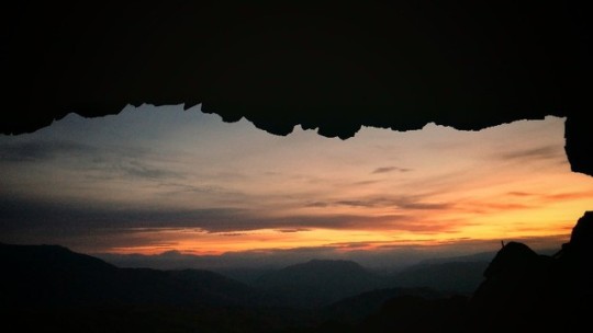
A night at the Priests Hole cave
The view of the Sun, rising from the Priests Hole cave in Dovedale is a sight to behold.
A slight feeling of trepidation accompanied us on this adventure to the Priest Hole Cave. Today I was joined by my mate Zane, who just over year ago had set off to spend the night in the Priest Hole cave and ended up nearly falling to his death, and has the Mountain rescue and a skilled helicopter pilot to thank for his rescue.
Looking back down the valley
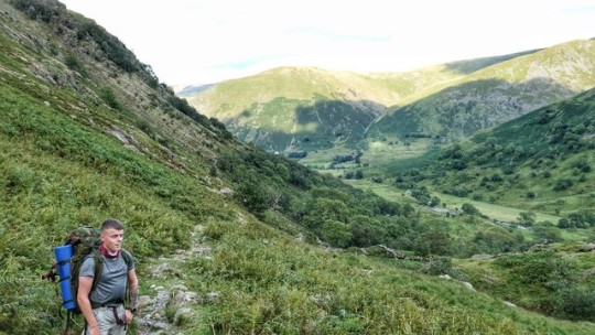
It's a beautiful day as we arrive at the Cow Bridge Carpark at Brothers Water near the village of Hartsop at the base Kirkstone Pass. After donning our boots and chucking the heavy packs over our shoulders, we set off in a southerly direction along a good farmers track which skirts around the Western banks of Brothers Water. The sun was splitting the trees already, with some fine views to be had.
Looking back down Dovedale towards Hartsop
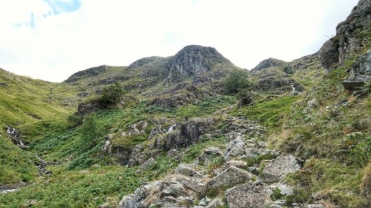
After about a mile at Hartsop Hall, the path splits off to a westerly direction up through some woods and gradually increases in height with Dovedale Beck below. After about a mile, after passing a small footbridge to your right, the path veers back to a southerly direction until you reach Dovedale beck. At this point the path gets rather rocky and eventually leads up some really steep steps in a south westerly direction. There are some good views back down the valley at this point.
Steep path up to Dove crag
The conversation on the way up was peppered with details of Zane's rescue just 12 months ago, as all the memories started flooding back and the scene of the incident came into view. One of his vivid memories was clinging to the cliff side waiting 5 hours to be rescued whilst watching people go about their everyday business down at Brothers Water Inn Campsite, totally oblivious to the predicament he found himself in just a couple of miles up the valley.
Good views from the cave over Dovedale
A good 20 minutes or so of step climbing will bring you out up top where a massive boulder to the right of the path, is your instruction to take a left from the path. From here there is a short sketchy section where the path is difficult to pick up, but after 30 metres or so, the path becomes clear once again and skirts around the Northern side of Dove Crag, eventually leading to the entrance to Priests Hole.
Watching the stars and discussing adventures
The Priests Hole itself is a bit underwhelming at first, appearing quite small, only being about 5 metres deep and about 10 metres wide. However once you are inside the hole, the views out to the north & east are quite stunning, framed by the outline of the cave.
Zane up early to catch the stunning Sunrise
On arrival at the cave at around 6pm, there were two people there already who had been there since 1.30 pm to secure their place in the hole for the night. One of the two was a professional photographer and his friend who was with him was on his first wild camp. About an hour later, a family of 5 turned up to join the four of us already there and then three students also pitched up at dusk. Three of the 12 set up their sleeping quarters just outside the hole as it was getting a bit cramped, although any major movements through the night would have resulted in an untimely fall to their deaths.
I cooked up some fabulous Philly Cheesteaks on the stove whilst Zane chatted with the other visitors, watching the last of the days light disappear. A clear night ensued, resulting in some delightful stargazing for those who weren’t having an early night. Despite the many guests staying in the Hole, the mix was excellent with good conversation into the night.
Zane taking time out
We slept really well despite the less than comfortable sleeping areas within the hole. We awoke at 5am to clear skies and a delightful sunrise, which is what a night in priest's hole is all about, the magnificent sunrise to the east and the stunning views over the mountains of Patterdale. It really is a sight to behold and something which I (and I'm sure Zane too) will never forget.

Myself admiring the views
Zane got the coffees on the go whilst I cooked up some tasty bacon on the stove for breakfast. It was quite relaxing just sitting cooking breakfast whilst watching the changing colours of the sky whilst the sun gently rose. After finishing our Breakfast, we packed away our gear and rubbish and headed back down the narrow path from the hole onto the main path. From here, instead of descending back down the steep path we had made our way up the previous evening, we headed slightly north over to the path that leads in a North Easterly direction and heads over Hartsop above How. This would give Zane another Wainwright to tick of the list. It's a lovely walk with fantastic views of the surrounding fells and down into Patterdale.


Hartsop above How

About a mile past Hartsop above How, look for a ladder style that straddles a wall to your right. Head over this style and follow the steep path down the side of the fell and into Low Wood, where the ascent gets really steep all the way back to the car park.


It was a pleasure to accompany Zane on this trip, returning to the place where he could easily have died just 12 months ago. It was inspiring to watch him face his fears and overcome them with a great sense of achievement, but also a deep sense of humbleness, a sense of humbleness that one can possibly only understand when you have stared death in the face and lived to tell the tale.

A quick drive over the Kirkstone Pass to Windermere and through to Ambleside to a lovely little café called the Copper Pot ensued, where we enjoyed a hearty English breakfast outside on the sun terrace. Fantastic local produce and fantastic service make this a stand out place for food in my opinion. And the cakes, don't get me started on the cakes, just don't
6 notes
·
View notes
Text
Stunning Lake District Bothy Experience
When you’re stood in the Warnscale Bothy at Buttermere, in the Heart of the English Lake District, looking out of the window, it’s hard to imagine that there’s a better view from a bothy in the whole of the UK, if not the world.

Buttermere from behind Warnscale Bothy
With a stay at Warnscale Bothy at Buttermere being on my radar for a couple of years now, it was a welcome suggestion from a work colleague, Zane, who suggested a stay at Warnscale when we were discussing a possible wild camp location. The weather forecast was studied, plans were quickly made and holidays were submitted.
We set off on a Sunny and warm Thursday afternoon. With us both living in West Cumbria, we headed up the A590 to Newby Bridge and at the roundabout, took the first exit onto the A592 to Bowness and then the A591 to Ambleside. We stopped at Ambleside for supplies. First we called into Beer Ambleside, a fine Beer shop selling a whole range of local and craft beers from around the country, for a couple of nice beers to enjoy with our tea. We then headed to Stockghyll fine foods, where we bought some bacon and Sausage for breakfast, plus some home made Banoffee Cookies, which were delicious. A quick visit to the wonderful Apple Pie Bakery for a freshly made baguette and a piece of Frangipani for afternoon tea was made, before continuing along the A592 to Keswick. From Keswick we joined the B5289 to Borrowdale, passing Rosthwaite, Stonethwaite and Seathwaite before heading over the Honister Pass until we reached the car park at Gatesgarth Farm. The car park costs £4 per day and this would be the start of our adventure up to Warnscale Bothy.

Buttermere from the path alongside Warnscale Beck
From the Car Park, we headed south and joined the path along Warnscale bottom. After about 1km, bear right over a foot bridge and continue to follow the path up the right hand side of Warnscale Beck, the path becomes quite steep here, but it is a decent path and is quite straightforward. After about 400 meters of ascent, the bothy comes into view up to your right at the base of large expanse of scree. It’s quite camouflaged against the backdrop of the old quarry mine workings.

The bothy is well camouflaged against it’s surroundings
On arriving st the bothy, we were greeted by a lovely young girl called Pin, from Thailand who was sat outside reading. She was on a 10 day backpacking tour of the Lake District, as part of a wider holiday of the UK. She was very polite and kind and spoke good English. I’m not sure if she appreciated our arrival and spoiling her solitude, but she didn’t seem at all put off.
The Bothy itself was very small and compact, but also very cosy. It had a couple of raised sleeping benches and a recently fitted stove.The view from the Bothy window was absolutely spectacular and must be one of the most stunning views from any Bothy on the Planet.

The view out of the bothy window
Having put our gear in the bothy, we brewed some coffee and ate our lunch which we had bought earlier from the Apple Pie Bakery in Ambleside, whilst admiring the stunning views down to Buttermere.

Enjoying a coffee and scran from outside the Bothy.
Having finished our tea, we headed off to summit Fleetwith Pike, a 30 minute walk from the bothy up an easy path. We passed Dubs Hut bothy on the way and had a little look around before heading on to the summit. Again, it’s a nice clean bothy with plenty of room with a stove. Always worth heading here if Warnscale is occupied.

The entrance to Dubs Hut

Dubs Hut obscuring the view over to Haystacks
15 minutes on from Dubs Hut, the summit of Fleetwith Pike was reached. It offers stunning views of Buttermere, Crummock Water and Loweswater, as well as the surrounding fells, especially over to the Wasdale area.

Buttermere and Crummock Water from Fleetwith Pike
It was very quiet on the summit, where we sat for 20 minutes and soaked up the solitude, admiring the magnificence around us, only being disturbed by the majestic butterfly's, possibly pollinating the wild Heather.

Dubs Hut being lit up by the evening light
From here, we headed back to the Bothy, passing Dubs hut again on the way. On reaching the Bothy, we had another visitor, a Scottish gent who had traveled down to do some photography. We sat outside and enjoyed the fabulous sunset whilst heating up our tea and enjoying our beers that we had bought earlier from Beer Ambleside.

Watching the Sunset from outside the Bothy
Having watched the last of the sun before low cloud brought a premature end to the evenings stunning natural light show, we continued to sit outside whilst Zane, Pin & Myself discussed previous mountain adventures, before deciding to call it a night.
The following morning started off quite bright, but soon clouded over, bringing with it some light but persistent rain. We cooked up some Bacon & Sausage on the stove and made some fabulous breakfast buns and enjoyed them with some freshly made coffee. Having packed up and said our goodbyes to Pin, Zane & I headed out into the miserable weather and set off back to the car.

Zane enjoying a Breakfast Bun
It was an enjoyable walk back, reminiscing on the previous days experience, discussing how nice it is to connect with wild places, trading the rapid pace of every day life for peace, calm and solitude.

One last photo on the way back to the car
Just before we reached the car it was nice to witness hundreds of sheep being shepherded back up into the fells after spending the night being sheared. The team of sheep dogs working their magic to control and guide the hundreds of sheep was a joy to behold.
I started off on this adventure with a work colleague I hardly knew and finished this adventure with a new mate. Looking forward to planning the next adventure.
#lakedistrict#hiking#bothy#outdoors#adventure#explore#wanderlust#nature#earth#wild#unesco#wild space#mountains#walking#hillwalking
4 notes
·
View notes
Text
Maol Bhuidhe Bothy Adventure

“You’re doing what?” They ask, as you tell them that you’re going to spend the night in a remote abandoned cottage in the middle of nowhere. “Madness” they say, as you explain the place has no gas, electric, running water, toilet or phone signal. “Well” I say to myself, let them think that, the wilderness lovers amongst us can keep the magic to ourselves.
Our journey started at Dornie, a little village on just off the A87 at the Northern end of Loch Duich. We arrived Thursday evening and booked into a homely B&B next to the Clachan Pub. Some lovely views of Eilean Donan Castle from here. The Clachan Pub was shut, so we headed over to the Dornie Hotel (60 second walk) for some evening scran. We enjoyed a good value hearty meal, whilst perusing the map for tomorrows adventures.
We awoke Friday morning and whilst we enjoyed the continental breakfast, it wasn’t quite the ideal preparation required for a day on the hills. However, a quick visit to the well stocked Dornie Post Office and store was a fulfilling experience. This little Post Office had everything we required with the lovely woman manning the shop making us feel especially welcome.

And were off
With our bikes safely attached to the bike rack and our supplies replenished, we headed north out of Dornie until we reached the signpost for Killilan, about a two-minute drive from Dornie. Turning right here leads onto a narrow road which skirts along the edge of Loch Long.

Loch Long
The views ahead are quite stunning here and we stopped to take a couple of photos. After about 5 miles, the road leads to a small car park at the gates of the Killilan estate. There’s ample room for about 15 cars.

Good biking on the tarmac track
With the gear packed, we made headway on the bikes along an easy 4 WD track which sits alongside the River Elchaig. The track is nice flat tarmac for a couple of miles before it gets a bit rougher. However, it is a delightful cycle with stunning views of Glen Elchaig. There’s not much up and downing and the track eventually leads to Loch na Leitreach.

Biking past Loch na Leitreach
On our journey, it was lovely to see so many deer in the Glen. Keep going along the track with Loch na Leitreach to your right. Once the end of the Loch is reached, you will be able to spot the Iron Lodge which is about another mile and a half further on.

Deer in the Glen
We got off the bikes here and chained them to the bridge that leads over to the Iron Lodge.

The Iron Lodge, where we chained our bikes to the bridge
From here there are two paths to Maol Bhuidhe, we opted to bear left (North). The path is quite easy to follow even though the weather was a bit miserable. It’s an enjoyable walk with some challenging terrain in parts, being especially boggy as you get nearer the bothy location.

The walk in continues
There are also some interesting river crossings which could be tricky when they are in spate. It’s quite mysterious but exciting feeling when the bothy’s fine whitewashed walls first come into sight.

The bothy comes into view
The feeling of adventure, of not quite knowing what to expect, of realising this is going to be your home for the night makes the approach all the more enjoyable.

The secluded little bothy awaits our arrival

The interesting river crossing to reach the Holy Grail
On entering the bothy and having a quick look round, the silence and lack of any other outdoors gear made me think that we could possibly be the only two people here tonight. Whether anyone else would appear later in the day remained a mystery. There’s a room out back and plenty of room upstairs. There’s probably enough room to sleep 15-20 people in all.

Rob getting the coffees on
The bothy was very basic and seemed cold and unwelcoming. This is where the magic happens. A few candles are lit and light fills the bothy and it now feels warm and welcoming. After a quick look through the visitors book, we got some coffees made and sat on the seat outside and stared into the vast beautiful wilderness that surrounded us. Whilst we munched on the sandwiches that we had bought from Dornie Post Office earlier in the day, we discussed what it must have been like to live here back in the day, especially in the throes of the demanding winter weather with only a fire to keep you company.

A game of cards to pass the time
We headed inside and made more coffee, Rob studied the visitors book and I prepared the fireplace. Having cleaned out the grate and the hearth, I placed a layer of coal (from the 10 kg bag of coal we carried in) on the grate. A clump of firelighters was then added, followed by kindling over the firelighters and then another layer of coal. We had a discussion and concluded amicably that six o’clock would be the time when the pinnacle of the bothy experience would begin, the lighting of the bothy fire. There was still an hour till this special moment, which we passed playing a fierce game of cards.

Rob admiring my handy work
Six o’clock arrived and I set alight to the bothy fire with an extra-long gas filled fire lighting device that I had brought in with us. Once the fire was lit, it was just a matter of leaving the fire to take hold and creating enough heat to burn the coal. After around 20 minutes the fire was roaring brightly and giving off great warmth, and warming the hearts and souls of two new bothy men. Rob quickly got the beef hot pot on the go which we enjoyed in front of the fire with a nice tasty beer.

Some nice tasty beers
Something quite extraordinary happens when you are sat in the middle of nowhere, in a stone building with only a fire to keep you occupied. You communicate, by that old fashioned communication method that’s very rare these days, talking. Talking and facial expressions and it’s an absolute joy. And you keep talking and wondering and questioning our very existence and how/why we climb mountains and connect with wild places and. There’s something very primeval about the situation we find ourselves in. This is where we once came from, just animals, wandering the landscapes and living off the land.

Myself and Rob mesmerised by the fire
A midnight excursion outside to observe the full moon and the stars, you’re wondering how far space goes, there’s so many things that our brains aren’t powerful enough to even begin to understand. We retire for the night with the fire still burning strongly.
On waking, the fire is out and the stone bothy is cold again, but a ray of morning sunshine is illuminating the bothy through the small window. Rob awakes to find that one of his boots enjoyed the warmth of the fire a little too much and although still wearable, now resembles a piece of modern art.

Our entry in the visitors book
It also appeared a little mouse had set up home in the side pocket of Robs ruck sack and taken a liking to his porridge, unfortunately for the adventurous little mouse, this would not become it’s permanent abode however. After some coffee and porridge, we pack our things including all left over rubbish, write an entry in the visitor’s book and head on our way.

Rob struggling to fit his gear through the door
We head right out the both and head east past the southern edge of Loch Cruoshie, a different way out than in. The weather is mixed, with sun, rain, hail, fog and wind all interchanging every few minutes.

Looking down Coire Odhar
continue east adjacent Allt an loin-Fhioda, until a tricky river crossing is reached. Fortunately, there was nothing to fear as Rob had packed some crocs for such an obstacle. With our boots and socks removed and our pants rolled up, we take it in turns to don the crocs and wade through the strong, chilly water.

Rob crossing the river using the “Crocs” method
Having crossed successfully, we continued east until the path meets another path at the North-Western foot of An Cruachan. From here we turned right and headed south up the dramatic Coire Nan Each.

An Cruachan in the centre

Heading up Coire Nan Each

Loch Mhoicean, illuminated by the afternoon sun

Myself getting a blast from the Hailstone shower
From here follow the path south west all the way back to the Iron Lodge. If it’s a nice clear day, you will get a stunning view of Loch Na Leitreach from the path down to the Iron Lodge.

Loch na Leitreach
On reaching the Iron Lodge where our bikes were waiting patiently, we made some cheese and chorizo wraps and had a quick snack before continuing.

Heading back past Loch na Leitreach
It was now just a case of the easy ride back to the car park. The weather was considerably worse than on the way in, but it was clearer, allowing for much better views of the surrounding hills.

Nearly back at the car park
Having reached the car, the walk out and cycle back took six hours. The cycle & walk in took four hours. You could easily walk in and walk out again using the short route, but we opted to make it into a bit of a loop, with a longer walk out, which I enjoyed more.
We got packed up and set off home. Our first bothy experience wont be our last.
#Adventure#travel#earh#mountains#nature#outdoors#hiking#Wanderlust#explore#Wildcamping#bothy#scotland#hillwalking
0 notes
Text
A truly special Lake District Light Show

To witness this stunning light show in the Heart of the Lake District put on by nature, was a truly special experience.
On a rare bright summers day in the Lake District, a Wild Camp up at Wasdale was calling to me. After quickly throwing the camping gear together, I headed off up the coast on the short journey along the A595 to Wasdale. I arrived 40 minutes later to glorious evening sunshine. Middle Fell was my summit of choice for tonight’s camp, as it would hopefully give me a majestic sunrise appearing above Scafell Pike, after arising from the cosy confines of my bivy bag In the early hours.

A trusty Herdwick, a staple of the UNESCO World Heritage Site
As I approached the stunning Wastwater, the Sun had was already at an angle that was illuminating the valley with glorious golden sunshine. I approached the junction at the Landing Stage (a small outcrop of land on the Northern bank of Wastwater) I turned left and headed a short way up the road to the village of Greendale, where I parked my car on the side of the road. I would leave my car here until my return in the morning.

The magnificent Wasdale Screes from half way up Middle Fell
I set off in a northerly direction and followed the footpath to the side of Greendale Gill. After about half a mile, the path splits off to the right for a direct ascent up to Middle Fell summit. It’s quite steep at first, but soon backs off into a meandering and progressive ascent over easy ground. I finally reached the chilly summit after about an hour and was impressed with the majestic views it afforded me.

Scafell Pike & Scafell towering above Wastwater
I quickly threw on a couple of extra layers to protect from the biting wind. A good half an hour was spent taking photos of the views before I unpacked and pegged out the bivy bag.

My home for the night on a small exposed outcrop
Middle Fell is quite an exposed summit with not many sheltered places to pitch higher up. I chose a nice little outcrop and set up my home for the night. I always feel a sense of satisfaction and contentedness when sleeping high up on a summit with only minimal equipment.

A view to the North East from Middle Fell Summit
Having cooked a lovely Bag of Ham and Eggs I sat down for coffee and triple chocolate cookies. Having taken in the views for a while, I retired into my cosy sleeping quarters and watched the sun disappear over the Horizon.

The sun setting to the West

Watching the last of the sun from the confines of my bivy
It proved to be a rough night as the wind got up and caused my bivy to flap about somewhat, waking me on occasion. Rather rude of the wind if you ask me. I arose from my humble abode at 5.33am and peered out of the bivy door to a hint of sunset and a jet blast of freezing air to my weary face. I armed myself with thick woolen hat, gloves and picture taking machine and made the short, wind ravaged walk to the summit before managing to drop down slightly into a sheltered position. It was from here that I watched the magic unfold in front of my very cold face.

The natural light show begins as the Sun rises
As the Sun continued to rise, the skies in front of me provided an ever-changing kaleidoscope of Orange, Red, Blue & Yellow, with the outline of the England’s Highest mountains a dark shade of black below.

The magical light show continues to mesmerise the watching audience
To witness this stunning natural light show put on by nature was a truly special experience. It always amazes me how dramatically the landscape changes at different times of the day and can turn an already fabulous landscape into something truly spectacular.

The bright sun filtering through the silvery clouds now beginning to shroud the Cumbrian mountains
Having witnessed this special moment and taken hundreds of photos. I packed up my camping gear and headed down the back down the path. A couple of times I was nearly helped on my way with the strength of the gusting wind being so forceful. The quietness in these places at such an early time of the morning is always a pleasure. Once out of the wind, all you can hear is the sound of streams flowing, birds twittering. No man-made sounds to be heard, it’s pure bliss & clears the mind.
Having reached the car, I returned to the A595 and headed home, taking with me some special memories of a magical sunrise in the heart of the Lake District.
#travel#earth#Adventure#mountains#nature#outdoor#hiking#Wanderlust#explore#Wildcamping#camping#sunrise
1 note
·
View note
Text
A’Chir Ridge Traverse, Isle of Arran
On approaching the Isle of Arran, the first thing that strikes you is the impressive range of mountains to the north as you sail into Brodick, with the Islands highest peak, Goat Fell rising prominently into the air.

Myself and Rob got the 7am ferry from Ardrossan over to Brodick. A return ticket from £7.50 and the journey takes roughly an hour, with several crossings throughout the day. There are plenty of amenities on board, with Coffee Bar, Drink Bar and a Café.
Having arrived at Brodick, we hopped on the Bus next to the ferry port and asked to be dropped off at the Glen Rosa Road end. It’s a slight detour for the Bus, but they happily do it, for a small cost of one pound per person. From there we walked up the track to the Glen Rosa Camp site, about a ten-minute walk. The Camp site is situated at the base of Glen Rosa, a fabulous setting with views up to the mountains. The camp site is wild and only has running cold water and toilets. Camp fires are allowed. At time of writing it is five pounds per person per night.
After pitching the tent and ditching the camping gear, we headed due west out the camp site, following the path for roughly 30 minutes before reaching a foot bridge.

Cir Mhor from lower Glen Rosa
At the foot bridge, turn left and follow the path upwards (west) for about 10-15 minutes.

Glen Rosa
There is a Sty in the fence to follow the path up to Cnoc Break. The path is a bit underused and is hard to locate but heads in a North-West direction before heading North up to Cnoc Break.

Looking back down Glen Rosa from Cnoc Break
Once on Cnoc Break the path is much more pronounced and it is easily followed up to Beinn a Chliabhain.

Looking towards Cir Mhor and Coire Fherghas

Myself on the Summit of Beinn Chliabhain

Rob heading onwards from the summit of Beinn Chliabhain
From the summit of Beinn a Chliabhain, head North West and across the ridge to Bealach an Fhir-bhogha.

Beinn Tarsuinn to the centre

A’Chir looking like great fun

The A’Chir ridge looking ominous

The beginning of the pinnacles on the A’Chir Ridge
The start of the A’Chir ridge. It is a series of pinnacles and whilst there are bits of a path, it’s up to you to choose your own line, making it as difficult (fun) as you so choose to. The ridge is classed as a moderate Rock Climb, which is above a grade three scramble. We had a 40 metre rope with us, and a small climbing rack.

Rob approaching the summit of A’Chir

Rob on the true summit of A’Chir
On reaching the highest point of the Ridge, the true summit is on the top of a monolithic rock, which is a little tricky to get on to.

Goatfell to the Right, North Goatfell in the centre, Mullach Buidhe to the left

Rob with Cir Mhor in the background

Cir Mhor from the summit of A’Chir
We started our descent of the ridge with a few more pinnacles to navigate. There are a few tricky areas that require a bit of thinking about and caution is advised. It would be very easy to find yourself in a bit of a predicament which I did on occasion. Fortunately we had the climbing gear which was really useful, with Rob having to lower me down from a ledge on one occasion.

The descent begins

Rob crossing an exposed section of the Ridge
Having navigated a few tricky pinnacles, there’s a difficult step that requires quite a tricky and very exposed down climb. You can also descend to the east via a short (20 metre) abseil. There is (on this occasion) some Tat (bits of climbing gear) already in position including some slings and a nut. We checked these thoroughly for to make sure they were secure before doubling up the rope and attaching to the tat. We both then proceeded to abseil down to the beginning of the next pinnacle.

Rob abseiling down the tricky step
We met a walker later in the day who had attempted this ridge alone with no climbing gear. He proceeded to downclimb this section and had a lucky escape after taking a bit of a tumble. A few scratches to his head and face and some damaged pride was the result. However, after speaking to the camp site owner later that evening, who has 30 years mountain rescue experience, he told us that a few have perished on this section over the years. The guy should be thankful he lived to tell the tale. Be prepared, read the guides, follow the advice, plan your route.
The beginning of the next pinnacle was quite tricky, with a bit of a climb around a large rock with a slight overhang, pushing you backwards a touch. I could have quite easily fell backwards if Rob hadn’t had hold of my back pack. I made it round with a helping hand.

The view down Glen Rosa from Coire Buidhe
From here on in it was rather straight forward until we reached Coire Buidhe, where we stopped for a spot of tea, before heading down the path back down Glen Rosa. It’s a lovely descent back down to the campsite, walking alongside the burn, with the evening sunshine lighting up the Glen. We stopped half way to give our feet a nice refresh in the cold water of the burn. You often find that the return is a trudge, but on this occasion it’s a really enjoyable walk in beautiful surroundings.

Refreshing our feet in the cold water, absolute bliss
Having reached the campsite, we joined some other campers around the campfire and discussed the days walking stories, whilst enjoying some well-earned dinner. Rob had brought some Dime Bar tray bake from Mimi’s Bake house in Edinburgh, which was rather delicious.
We packed up the following morning and called a cab back to the port at Brodick. It cost £5 between us, but it saved us a 45-minute walk in the rain with a lot of gear, so it was money well spent.
There was much to go at in the mountains of Arran which we didn’t have time for, so a return journey will be on the cards at some point in the future. It’s a beautiful island and the people are really welcoming.
1 note
·
View note
Text
Climbing Needle Ridge, the Lake District
There are stunning views in all directions when climbing Needle Ridge in the English Lake District, but the most beautiful is the view looking down to Wastwater, England’s deepest Lake.

Rob topping out Needle Ridge, with Wastwater in the background
There British Lake District is well known for its abundance of Climbing opportunities, but probably the most famous is Napes Needle, situated on the West side of Great Gable at Wasdale Head. Today we were to climb Needle Ridge, a five pitch V. Diff route which starts at the base of Napes Needle.
A short journey North up the A595 from our home in Millom, we soon arrived at Holmrook and turned right, heading for Wasdale Head. The drive alongside Wastwater as you get deeper into the heart of the surrounding mountains is breathtaking. We arrived at Wasdale Head around 10pm, parked on the village green, and got our gear together.

Ryan and Rob getting the gear ready at Wasdale Head village Green
Wastwater was glistening in the morning Sun, the birds were tweeting merrily, the surrounding mountains were carpeted with lush green grass and the relaxing sound of running water filled the clean morning air.
Having got our gear together, including some fresh pies and sandwiches, we headed east out the car park along the farm track, past the little church, through the farm and along the path until we reached a wooden footbridge.

The Napes in the distance, the location of today’s climb
We filled our water bottles from the beck, before proceeding along the path towards Sty Head. It takes about an hour to reach Sty Head along an easy path.

Heading up the path towards Sty Head
The arrival at Sty Head is marked by a small pointed cairn. We stopped here for a snack and to take on some water as the morning heat was already making us rather thirsty. Turn left at the cairn and bear left again to take the walkers traverse path to take you onto the west side of Great Gable.

The small pointed Cairn at Sty Head

Heading along the Walkers traverse path towards the Napes
On making our way around a small crag, it’s a short walk up a scree slope before the Napes Needle comes into view

The Napes Needle
We continued up a short way before a small scramble to “Thread the Needle”

Rob & Ryan scrambling to the start point
After reaching the base of the Needle, it was time to start the climb of Needle Ridge. The climb is a five pitch V. Diff route. Rob would be the lead climber. We had two 50 mere ropes. I belayed for Rob until he reached the anchor point of each pitch. Rob would then belay each of us up to the anchor point.

Rob assessing the situation

Ryan starting the first pitch

Ryan completing the crux at the start of the first pitch
Rob was using a selection of Nuts, Cams and Slings for protection and anchoring.

Ryan proceeding ahead

Rob leading the way

Myself at start of the third pitch

Rob heading on up

The incredible view down to Wastwater

Ryan heading up the final pitch
After the final pitch their is a fine section of really exposed Grade 2 scrambling, with tremendous views all round. With the climbing gear now tidied away, we were free to climb over the scrambling section with ease and make our way up to the summit of Great Gable.

Rob looking pleased with himself

Ryan treading carefully whilst Rob watches on

Rob admiring the view down to Wastwater in the afternoon Sun

Just completed a tricky step

Ryan holding on tightly (and looking terrified)

Rob finishing the scrambling section with the Scafell range in the background
With the fabulous scrambling section now completed, it was a short ten minute walk up to the Summit of Great Gable. A ten minute stop for food and water at the summit ensued, plus time to reflect on an epic days adventures.

Ryan& Rob reflecting on the days adventures
It had been a truly unforgettable day of climbing in an area of incredible natural beauty. But it was now time to head down Great Gable to the North, a steep, loose path, before reaching the foot of Kirk Fell. From there it was a case of heading back down toward Wasdale Head.

Ryan & Rob heading back down towards Wasdale Head
It is a very steep path along loose ground, which is hard going. You’ll be lucky if you don’t fall on your backside a number of times. Having devoured the last of our water at the summit of Great Gable, it was more than delightful to reach the beck at the bottom of the path and drink the refreshing cool water uncontrollably. After a bit of a cool off we carried on back to the car park which we reached about 6pm.
A fabulous day out was had by all, even Ryan who spent most of the day absolutely terrified
1 note
·
View note
Text
Stunning English Lake District Wild Camp
The sheer natural beauty that surrounds you on a Lake District Wild Camp is the most humbling of experiences.

The Sun setting from the Summit of Great Gable
Having had a wonderful wild camping experience on Suilven at Lochinver a few weeks ago, I had chosen Great Gable in the beautiful English Lake District as a possible Wild Camping location due to the stunning views that you get in every direction from its summit. With a fabulous mid June weather forecast for the weekend ahead, I set off up to Wasdale Head at five in the evening. I reached Wasdale Head at six, with it being just an hours drive from my home. I made use of the ample parking on Wasdale Head Green and set off up Wasdale Valley, heading for the Summit of Great Gable, the pyramid shaped Mountain at the head of England’s deepest Lake, Wastwater

Great Gable ahead through Burnthwaite Farm
After heading out the Car Park and along the gravel road past the small church, head towards Burnthwaite Farm. Fork left at the farm and through the gate to follow Moses Trod Path. Cross the wooden footbridge, and follow the path, gaining height slightly until you reach the wooden gate.

Looking behind where I’ve just come from
Head through the gate and follow the path through Bursting Knott and Toad How. Follow the path until you reach Sty Head, where you will reach a Cairn and a large rock with a Stretcher Box Behind.

The Stretcher Box at Sty Head

The Cairn at Sty Head, with Sty Head tarn behind
On reaching the above Cairn (which will roughly be about an hour from the Car Park), head North West (Turn Left) and follow the stepped path up to the top of Great Gable. This section should take roughly an hour, so two hours in all to reach the summit from the Car Park. at Wasdale Head.

The first view of the Sun on reaching the Summit

Yewbarrow and Middle Fell casting a shadow over Wast Water
Having had a quick saunter around the summit, I settled on a nice rock to sit and watch the Sun go down. It was a bit chilly on the exposed summit so I put a couple of extra layers on to protect me from the cool breeze.

The Sun setting over Red Pike now getting a bit lower

Crummock Water at Buttermere glistening in the dwindling evening light
Having watched the sun disappear over the Horizon, I set off to find a suitable patch of grass to pitch my bivvy. This proved more difficult than I suspected with vast areas of the Summit covered in Rocks. Eventually I found a small grassy area just large enough to set up camp for the evening.

Home for the evening, managed to pitch the bivvy in between some rocks
Having slept for 4-5 hours it was time to wake up and catch the Sunrise. I was quite surprised the couple of times I woke through the night, just how light it was on the summit.

The Sun rising from the South East at 4.45 am
I awoke to a beautiful sunrise from the south east. It was a clear, calm morning, with much tranquility to be felt. The mountains were glistening in the morning sunlight, low cloud was rolling in from the sea which interspersed between the fell tops, forming a fluffy white covering.

Great End, Ill Crag, Scafell Pike and Scafell shrouded in clouds

Looking across to Great Langdale from the summit of Great Gable

Wast Water under the cover of clouds

Scafell Pike & Scafell lit up by the Morning light
Having watched the magnificent sunrise for an hour or so, it was time to pack away my camping gear and retrace my steps back down the way I came and return to Wasdale Head Car Park.

The view from Sty Head down towards Seathwaite
It was a lovely walk back down to Wasdale Head, it was so quiet and peaceful at that time of the morning and I didn’t see a soul. Only the sounds of the flowing rivers and the singing birds to keep me company as I headed down the path in the early morning sunshine.

Looking down to Wasdale Head from Bursting Knott

Illgill Head to the left, Yewbarrow to the right
I reached the car park at Wsdale Head at eight in the morning and made my way home. Wast Water was flat calm, with the surrounding landscape appearing on the surface of Wast Water like a giant mirror. It was quite an incredible sight as I drove out of Wasdale along the shores of Wast Water.
#travel#earth#advenure#mountains#nature#outdoor#hiking#wanderlust#explore#sunset#wildcamping#camping
1 note
·
View note
Text
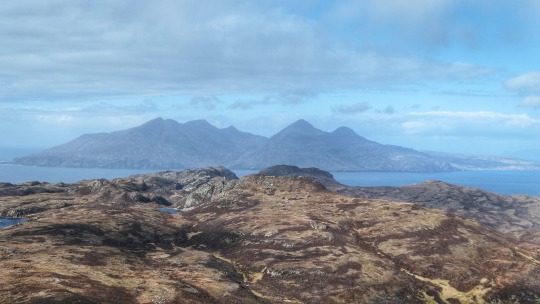
A Rum Adventure
The first thing that strikes you when arriving on Rum is the remoteness of the island and how quiet it is. My mate Adam and myself arrived on Monday lunch time after a couple of days exploring the neighboring Isle of Eigg.

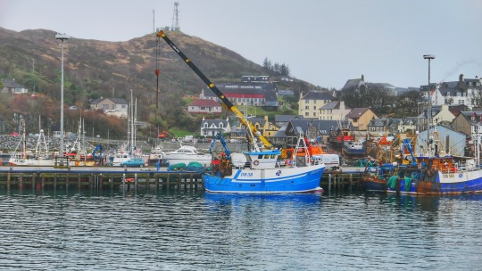
The MV Loch Nevis leaving Kinloch Port
We arrived to a cold and windy day at the end of March and were met at the ferry terminal by the campsite owner who directed us to the campsite, which was a 5 minute walk away. Our camping pod cost £15 per night (winter rates). This would be our home for the next three nights. We were able to use all the excellent facilities at rather the Rum Bunkhouse (Which is a 2 minute walk away). The bunkhouse is situated in a lovely place with views across the bay.

Our Camping Pod at Kinloch Campsite
With it being rather cloudy and extremely windy on our arrival, we stayed low and walked out to Kilmory. It’s a long easy walk along a 4WD track right down to the beach. Kilmory Glen has been the location of a Red Deer study since the 1970′s, with many Deer to be seen in the glen.

The path down Kilmory Glen with Red Deer ahead
It’s a 10 mile walk to Kilmory beach and back from Kinloch. There’s some nice views across the sea to the Skye Cuillin Ridge if it’s not too cloudy.

A Red Deer being inquisitive at Kilmory Glen

A dwelling at the end of Kilmory glen, with the Isle of Skye across the sea.
After returning to Kinloch, we visited the small but well stocked shop and headed back to camp. We made tea in the Bunkhouse ans sat in the relatively quiet communal area and watched the sun go down, with a couple of well earned cool beers.
The night brought with it snow and blizzards and we awoke to a covering of light snow. The weather was horrendous until lunch time, when it brightened up a bit. Had a walk over to Harris Bay in the afternoon to see the mausoleum and the Rum Ponies.

Part of The Rum Cuillin Ridge from the track to Harris
It’s a good 16 mile round walk to Harris and back, but it’s a good 4WD track and with the clouds clearing the were some stunning views of the Rum Cuillin ridge.
On reaching Harris Bay, the four season weather changed to Summer for half an hour, which made for some belting views of the Bay and the Rum Ponies.

The lovely Rum Ponies

The Mausoleum at Harris Bay

Highland Cattle feeding on some Hay
The walk back to Kinloch brought more four season weather, Snow, Hail, Rain & Sun, but there was some more great views of the Cuillin Ridge to take in which made the walk back enjoyable.

The Rum Cuillin Ridge from the Road to Harris

A stray boulder beside the road on the way back to Kinloch
Having walked a good 16 miles in at times horrendous weather, it was nice to get back to the Bunkhouse, get a warm shower and get into some clean clothes. A relaxing evening ensued, with a nice Steak Pie and a couple of lovely beers picked up from the shop.
Wednesday started better with some glorious sunshine, although it had put a bit more snow down overnight and it was still excessively windy.
Decided to have a walk up the Cuillin Ridge to see what the conditions were like. The walk up to the first mountain on the Ridge, Hallival, is a fabulous walk alongside some lovely waterfalls.

Waterfalls beside the path up to the Dam
It’s a decent path up to the dam, where after you need to use your map and compass to guide your way up the mountains.

Hallival and Askival ahead
The further up Hallival I got, the more difficult the terrain became, with quite a bit of scrambling involved. However, the thin sprinkling of frosty snow on the rock was making it quite treacherous in places.

Nearing the Summit of Hallival
More scrambling was involved on reaching the summit on precarious terrain.

Looking over to Eigg from the summit of Hallival

The Summit of Hallival
Having decided that the terrain was too treacherous to carry on to Askival, and the wind now at gale force with it actually blowing me over at one point, I decided it best to head back down and leave the Cuillin Ridge for a better day.

Walking back down to Kinloch
Having reached Kinloch Castle, it was lovely to see a lone Deer mooching about in the castle gardens. It was nice to share a few moments with such a beautiful wild animal up close.

A lone Red Deer in the Castle gardens

Kinloch Castle
A quick visit to the Honesty Craft shop ensued, where I bought a small painting of a view from Kilmory to Skye, and left my £20 in the honesty box provided. A great little craft shop with a variety of crafts for every price range. Back to the Camping Pod for a beer before returning to the Bunkhouse for Tea and a look back at the photos from the last few days before our return home in the morning.

The Isle of Skye from the Ferry back to Mallaig
The next morning was the best day so far but unfortunately it was the day we would be getting the ferry back to Mallaig. After a bright sunny morning, one quick last walk round the bay was had before packing up and returning to the Ferry Port to catch the MV Loch Nevis back to Mallaig. It was a fabulous sunny day and we got some tremendous views of the neighboring islands.

The Isle of Eigg from the Ferry back to Mallaig
Having reached Mallaig, it was a long rail journey back to Edinburgh, but the breathtaking views more than made up for the long journey.
6 notes
·
View notes
Text
Mini Adventure on Eigg
The first thing that strikes you when you arrive on the Isle of Eigg is not the massive chunk of rock that towers over the landscape, but the down to earth friendliness of the residents.

My mate Adam and myself arrived at Mallaig Ferry Port at 8.30am and parked at a free car park around at the Southern tip of the port, roughly two minutes walk from the Ferry port. There is enough space for about five cars if you get there early enough. A quick call into An Cala coffee house at the Port entrance for a coffee and bacon roll proved a delightful experience.
Mallaig Port
The ferry ticket to Eigg cost £7.90 return and took around 3 hours 30 minutes due to the route. The ferry ride was comfortable with cosy inside seating and facilities, with a refreshments/food bar. There is an option to stand on deck if you want to admire the views, although on our journey it was rather foggy, so there wasn’t much to see.
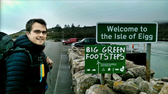
Welcome to EIgg
On arriving at Eigg, there was a small gathering of islanders waiting to unload supplies. We were greeted by our host who picked us up in the Land Rover and took us across the island on a narrow road, with a quick stop at the small but well stocked shop at the port, until we reached our destination, Laig Beach Bothy.
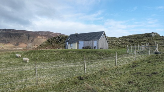
The Laig Beach Bothy
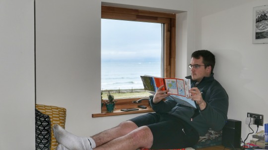
The Laig Beach Bothy is a relatively new building. It is small and cosy and set in the most beautiful location at the end of a farm track at Laig Bay. It is beautiful inside, with all that is required for a fantastic stay. The views out of the large front sliding door, across the bay to the Rum Cuillins is quite something.

The view over to Rum from the Bothy
The bothy comes equipped with double bedroom, 2 single beds in the roof space, a bathroom, kitchen, wood burner, Wi-fi and a Bose bluetooth sound system. Two mountain bikes are also included in the price of the bothy, which was £250 for two nights at winter rates.
Adam weighing up some routes
Having settled in and had some tea, we checked out a few maps and books of the area and made some plans for the following day. The bothy owner picked us up early evening and gave us a lift to the pub. The Pub is actually the community centre at the port, which also doubles as a cafe and restaurant.

The view of Laig Bay from the Bothy
The locals made us feel really welcome and they all seemed to know our names. They were full of advice for exploring the island and spoke with us like we had lived on the island for years. A few beers and some lovely home made curry and rice set was most welcome. Highlight of the evening was watching a couple of the local children build massive cardboard Castles and asked to help pick the winning castle. We headed back to the bothy where we had a couple of beers from the local brewery, before calling it a night.

Out on the bikes early
We awoke early the following day and made a hearty breakfast. The views over to the Rum were fabulous. We set off on the bikes and made our way across the island to the base of the Sgurr of Eigg path, the massive chunk of rock that dominates the Islands landscape.

The Sgurr of Eigg
We hopped off the bikes and set off up the path. It was very boggy in places, but the path is decent and not too difficult. Half way up the Sgurr, the path winds upward into a gulley, where some beautiful views to west suddenly appear.

The Isle of Muck from the gulley in the Sgurr
A short walk from here finds us at the summit of the Sgurr. The weather had cleared by now and there was some glorious sunshine, despite the strong winds which were fierce on top. There are some fantastic views over to the Rum Cuillins from here.
The Rum Cuillins from the Summit of the Sgurr
We made or way down and diverted slightly from the path over to Loch Nam Ban Mora. The views of the Rum Cuillins from here across the Loch makes for a great photo opportunity.

The Rum Cuillins from Loch Nam Ban Mora
Back on the bikes, we headed down to the community centre and stopped for a coffee and sandwich.

The view west from the Sgurr Path
Our next point of call was the Massacre and Cathedral Caves. However, when we reached the coastal path, the wind strength was ridiculous, so we didn't fancy the walk down the cliff side.

Biking back from Cathedral Caves
The wind was making it really cold by this time, so it was time to head back across the island to the bothy. After a quick freshen up, we fired up the wood burner and put on the tea. With it being Sunday the pub was closed, so an evening chilling, listening to music and drinking a few refreshing beers was in order whilst watching the sunset over the Isle of Rum from the comfort of the Bothy.
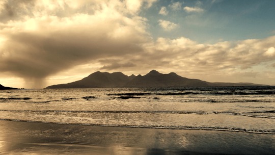
The Rum Cuillins from Laig Beach
On awakening the next morning, it was another fine day. We made breakfast, packed up our gear and headed back to the port in our Land Rover taxi service. Our stay on Eigg was fantastic, the people there couldn't have made us feel more welcome. It’s a beautiful island with plenty of places to explore and plenty of places to escape. We will definitely be returning some day. Next stop Rum.
6 notes
·
View notes
Text
Grand Traverse of An Teallach
The first glimpses of the An Teallach Ridge from the A832 were quite breathtaking. A mixture of awe, excitement and trepidation.

After a magical couple of days up at Suilven, we headed south down to Dundonnell with a short visit to the lovely Ullapool to stock up on supplies, maps and Ice Creams.
We arrived at the peaceful but beautiful village of Dundonnell late afternoon and checked in at the Sail Mhor Croft Hostel (£17 per night). The hostel was in a beautiful location on the south shores of Little Loch Broom. The rooms were adequate and the facilities were good. However there doesn’t seem to be anywhere to buy supplies nearby, so it’s a good idea to stock up before you arrive.
I spent a couple of hours napping and downloading previous walk photos, whilst Rob got the map out and finalised the route. A quick visit to the Dundonnell Hotel Bar, which was a 5 minute drive away, for supper and refreshments was a good choice. The Bar was welcoming, the food was good and well presented and the beer was fine. Roughly £40 for two eating two courses and a couple of drinks each. We retired soon after ready for a long day of mountaineering ahead.

The first glimpse of what we letting ourselves in for
We awoke early to a fabulous sunny morning and drove to our start point for 7am, which was only a 5 minute drive away. After a long walk in on a good off road track, we reached the point where we needed to turn off the track and head right up the path towards the first summit of Sail Liath. The path isn’t very well trodden, but you can make it out if you look closely. The views of the surrounding mountains are absolutely stunning

Amazing views of the surrounding landscape
Follow the zig zagging path up the boulder field taking note of the small cairns to follow. On reaching the top, there is a short but easy walk along the path to the Summit.
At this point we took shelter from the wind and had a sandwich.

Lovely place for a Ham & Chorizo sandwich
After a quick bite to eat we got cracking and made it up to the first point of interest, Cadha Goblach, 960m. It was here we met Jez, a bagger of epic proportions. We would meet Jez several times throughout the day as he ran around bagging every peak within a 2 mile radius. A very lovely chap he was. The size and enormity of the task ahead now comes into focus.

The Walk ahead
A brisk stop to admire the fabulous views was had before heading on to the pinnacles. This is where the scrambling fun comes in. The pinnacles are made of sandstone and are very rough in dry weather, however sandstone tends to be very rounded due to erosion and can be a bit difficult to find good holds.

Rob eyeing up the first Pinnacle
It turned out to be quite exposed in places and a bit tricky in places, but overall the scrambling was really fun. There is a bypass path around the pinnacles for anyone not to keen on the scrambling.

The First Pinnacle
The first pinnacle looked a bit tricky and at one particular point I needed Rob to get the rope out to give me peace of mind. Turned out an easy move, but there was a long drop if I slipped, which made it all the more difficult.

Another Pinnacle
We scrambled over several pinnacles and negotiated some narrow ridges, which I imagine in the wet would be rather treacherous.

Rob crossing a narrow ridge

Rob & Jez scrambling up another pinnacle

Rob negotiating a narrow ridge
After the narrow ridge above, it was a last scramble for the time being up to Lord Berkeley’s seat, which in itself was a fabulous vantage point. However we moved further down to a more precarious ledge for a bite to eat and a marvel at the hundreds of meters of drop into the Loch below.

Rob taking time out on a precarious ledge just down from Lord Berkeley’s seat.
We carried on from here making our way up to the first Munro of the day, Sgurr Fiona at 1060m. There was a decent but easy scramble up to the summit. From this summit we continued to navigate down a steep rocky path down to the bealach and up up to the second Munro of the day, Bidein a Ghlas Thuill at 1062m. The view of the Ridge we had just walked over from this viewpoint is quite breathtaking. It really does look majestic but intimidating at the same time.

Rob marvelling at the nonsense we have just walked over

Standard picture in front of today's conquest
From here we headed east over some good scrambling ground until we reached the fault line where the sandstone changes to Lewisian Gneiss where the terrain turns into a boulder field before reaching the summit of Glas Mheall Liath. We headed South East down a very loose boulder field which was hard going. After about 30 minutes, we reached the last of the boulders and made our way down some more difficult heather covered terrain. We lost our bearing slightly, which meant having to cross a large expanse of uneven ground, until we eventually made our way back to the path.
Follow the cairns to keep on the path. There is some stunning water falls to marvel at on the way back. As we returned to the car, the path seemed to disappear slightly and became difficult to follow. It lead us through a wood, into a field, through a river, through another wood and over a fence before we reached the road. It was then just a short walk back to the car. We headed back to the Hostel and quickly got showered before heading to the pub for a well earned feed and celebratory beverage.
2 notes
·
View notes
Text
Magical Suilven Wild Camp
After the momentary glimpses afforded of the mystical Suilven from different vantage points on the beautiful drive up the A837 to Lochinver, nothing quite prepares you for your first proper sighting of this magnificent mountain as you drive up Canisp Road to the Walkers Car Park. Across the magnificent landscape, Suilven rises out the ground in the distance like something from a fairy tale.

Rob and myself arrived in Lochinver the previous evening and checked in to the clean and functional Bunkhouse (£22 per night). We soon found a great little restaurant called Pete’s, which was a short walk away. We were served up some great local produce for a reasonable price (£45 for 2 people and a couple of beers each). After a couple of refreshing local beverages, we retired to the Bunkhouse and finalised our plans for the following morning.
We arose to a bright sunny day with a sharp cool breeze. After parking up at the Walkers Car park half way up Glencanisp road, which has enough spaces for about eight cars, we hauled our packs on and continued up the road until we reached Glencanisp lodge. The route then continues for a couple of hours along a well-used stalkers track with fine views of the mountain along the way. On reaching a second footbridge, where we turned off the stalkers track to the right and onto a trodden path.

Suilven poking out the landscape from the Car Park
The path up to the base of Suilven is very boggy in places, but some major path repair work from the stalkers track to the top of the Mountain was in its very early stages and is hoped to be finished by the spring of 2018. Having reached the base of Suilven, it was a steep and arduous climb up the gulley to the Bealach on a decent, if unstable at times, zig zagging path. We had to stop several times nearer the top whilst the Helicopter delivered bags of stone for the ongoing path repairs.

The boggy path up towards the base of Suilven
Having reached the bealach we headed east up to the ridge, and took time out to have a sandwich and admire the magnificent views all around.

Rob taking a well deserved rest just above the bealach
After 20 minutes of admiring, we emptied non-essential gear from the packs whilst we went to climb the Ridge summits. The Ridge has two summits, the first Meall Meadhonnach, has a clear route down and up, with some tricky scrambling in places.

Heading across the ridge towards Meall Meadhonach
The route to the final summit, Meall Beag is less well trodden, with walkers tending to give the final summit a miss due to its formidable stature. However, it is a fun scramble which can be achieved with a careful ascent of the route up to the left-hand side as you look at it. Rob and myself sat on the final summit for a while admiring the views and feeling a sense of accomplishment.

The imposing Meall Beag is ascended up the left hand side as we look
The scramble over the ridge summits and back to the bealach added a good two hours to the walk, but if you’re going to make the effort to climb Suilven, then it’s a must do if you like a good scramble.
Having re-filled our packs, and the sun starting to set, we headed up Caisteal Liath,the mountains summit proper, which is a fifteen-minute walk up a good, solid path.

Rob at the Summit
The views back over the ridge from the summit are quite something. There was a constant stiff breeze on top, a bit too stiff for camping, so we headed west down from the summit to a small plateau, where we set up camp for the evening.

The view west down to Lochinver
We sat and enjoyed the views down to Lochinver as the sun went down, whilst enjoying some hearty Beef Carbonade and a couple of refreshing beverages. It was nice to look down in the night skies and see all the little villages lit up by street lights and marvel at the millions of stars in the sky.
On awaking early to a cold and fresh morning, we quickly packed our gear together and made our way back up to the summit. We found ourselves above a stunning cloud inversion which was racing in from the south east and swirling around Suilven, as if the sharp ridge was cutting through the cloud like a knife cutting through a white tablecloth.

The early morning view from the summit looking east along the ridge
After marvelling at the views for a while we made our way down to the bealach and retraced our steps back down the gulley to Loch na Gainimh, where we were able to freshen up and replenish our water supplies.

We headed back along the stalkers track to the car park, with plenty of views of the incredible Suilven along the way. Having reached Glencanisp lodge, there Is an honesty shop run by the Assynt foundation, where for a small fee, you are able to purchase some tea or coffee, an ice cream, or some local crafts.

Looking back towards Suilven from the stalkers track
I would allow a good three hours for the walk in to the base of the mountain, a good half hour to walk up the gulley to the bealach and possibly another hour to admire the fine views from the top. An extra couple of hours would be required if traversing the ridge and back.
Having reached the car, with some amazing memories of such a magical wild camping experience freshly stored in the mind, we headed back to Lochinver, where we were able to get showered at the leisure centre for the small price of £2.50.
A quick stop for a spot of lunch at the rather good mission café underneath the bunkhouse provided some much-needed fuel for our continuing journey south to Dundonnell, where we would attempt the An Teallach Traverse.
0 notes