
Statistics
We looked inside some of the posts by zeloan and here's what we found interesting.
Average Info
Notes Per Post
10
Likes Per Post
3
Reblog Per Post
7
Reply Per Post
0
Time Between Posts
3 days
Number of Posts By Type
Text
17
Last Seen Tumblr Blogs


Fun Fact
US Tumblr user growth rate is estimated to slow down to 4.1%.
Text
𝐁𝐚𝐬𝐚𝐰𝐚𝐤𝐤𝐮𝐥𝐚𝐦𝐚 𝐓𝐚𝐧𝐤 𝐒𝐫𝐢 𝐥𝐚𝐧𝐤𝐚
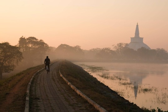
A well-known reservoir in Anuradhapura is Basawakkulama Reservoir, also known as Abhayavapiya. Both domestic and international visitors to Anuradhapura seldom fail to visit the lake. Tourists who are looking forward to viewing an amazing sunset over Abhayawapiya Lake could take advantage of this fantastic chance. because it is a stunning sight. Swarnamali Maha Dagoba has brought various hues to the landscape in addition to the Abhayagiri Lake. King Pandukabhaya, who governed the nation from around 377 to 307, constructed it. The Basawakkulama tank is where the ancient Anuradhapura irrigation system's rainwater harvesting process begins.
Abhayawapiya Wewa has a maximum water capacity of 1910 acre-feet. About 174 hectares of water may be stored in the tank. The bund measures 3900 feet in length and 15.5 feet in depth on average. The lake's primary purpose is to offer pilgrims and locals access to clean water, sanitary amenities, and 450 acres of land for irrigation. Abhayawapiya Lake is infertile even during the monsoon season. The presence of the Biso Kotuwa, Pita Wana (overt flow of water), and Sorowwa (outflow of water) in the Wewa gave the building additional significance.
𝗥𝗲𝗮𝗱 𝗠𝗼𝗿𝗲:
𝗚𝗼𝗼𝗴𝗹𝗲 𝗠𝗮𝗽:
#BasawakkulamaLakeSriLanka#BasawakkulamaTank#AbhayaWewa#beautifullakeinsrilanka#PlacestovisitAnuradhapura#Ruwanwelimahaseya#Anuradhapura#AncientCity#SacredCity#WorldHeritagesite#NorthCentralprovince#LakesSriLanka#travel#travelsrilanka#srilanka#srilankatravel#srilankatrip#srilankatourism#ceylon#paradiseisland#destination#nature#naturelover#VisitSriLanka#BeautifulplacesSriLanka#PlacestoVisitSriLanka#Travelisland
0 notes
Text
𝐋𝐨𝐭𝐮𝐬 𝐓𝐨𝐰𝐞𝐫 𝐢𝐧 𝐒𝐫𝐢 𝐋𝐚𝐧𝐤𝐚
Lotus tower is the highest tower in Sri Lanka. In Sinhala, Lotus Tower is also referred to as "Nelum Kuluna". Lotus Tower is one of the most well-known tourist attractions in the town of Colombo, Sri Lanka. This tower is the highest in South Asia, the 11th tallest in Asia, and the 19th tallest in the entire globe, standing at a height of 356 meters. It has grown to be one of the top tourist destinations in Sri Lanka and is well-liked by visitors.
The Lotus blossom serves as the design inspiration for this structure. In Sri Lankan tradition, the lotus represents purity and is seen to represent the nation's thriving progress. Two inverted trapezoids will also be used to build the tower foundation, which takes its design cues from the lotus throne. A seamless transition between pink and pale yellow is intended for the tower's hue, which will be accomplished by coating the glass. The tower has a height of 350 m (1,150 ft) and a floor area of 30,600 m2 (329,000 sq ft). It ranks as the 11th tallest tower in Asia, the tallest tower in South Asia, and the 19th tallest tower overall.
𝗥𝗲𝗮𝗱 𝗠𝗼𝗿𝗲:
𝗚𝗼𝗼𝗴𝗹𝗲 𝗠𝗮𝗽:
#LotusTowerSriLanka#NelumKuluna#TallestTowerSriLanka#Colombo#TouristAttraction#Viewpoint#travel#travelsrilanka#srilanka#srilankatravel#srilankatrip#srilankatourism#srilanka🇱🇰#ceylon#paradiseisland#destination#nature#VisitSriLanka#BeautifulplacesSriLanka#PlacestoVisitSriLanka#Travelisland#lotustower#lotustowercolombo#lotustowerlightning#lotustowerfireworks
0 notes
Text
𝐌𝐞𝐞𝐲𝐚𝐧 𝐄𝐥𝐥𝐚 𝐅𝐚𝐥𝐥𝐬 𝐒𝐫𝐢 𝐋𝐚𝐧𝐤𝐚
Many environmentalists, waterfall aficionados, and members of the general public in our nation are unaware of Meeyan Ella Falls. At the very least, few people even know where it is. This waterfall is situated close to the Ihalakotte train station along the Kandy railway line. Helan-Madiththa, a location on the Alagalla mountain, is the source of the stream that forms the Meeyan Ella waterfall. The waterfall's original course passed through the villages of Walagoda and Thalagolla before merging with Thalagolla Oya. It then fell as a single stream over a rock. The connection between Ma Oya in Boella and Thalagolla Oya follows.
However, the waterfall now divides into two segments with a 50-meter separation. A fascinating tale of how a large waterfall was once split into two smaller ones. To carry products, especially Ceylon tea from Kandy for export during the British Colonial Era, the Colonials built a railway line between Colombo and Kandy. The mid-1800s saw the construction of the railroad line between Polgahawela and Kandy. The Colonials at Alagalla had the difficult task of building the railway over the substantial waterfall Meeyan Ella. As a result, the Colonials were forced to complete the enormous task of digging a tunnel through the Alagalla rock, which was around 304 meters (1000 ft) deep. Instead, they looked for other options, and after examining the location, they came to the conclusion that the only choice was to obstruct the cascade upstream and carve two significant grooves into the rock. As a result, instead of one large waterfall, the water would cascade into two smaller ones. After the job was finished, a horizontal cut through the Alagalla rock measuring about 426 meters (1400 feet) long and five meters (18 feet) deep was made in order to build the railway line, which was finished up to Kandy in 1867. This groove was unable to handle the tremendous rush of water in the stream during severe downpours, and the railway was repeatedly carried away. Due to their difficulty pronouncing "Meeyan Ella," the British Colonials dubbed the waterfall "Meen Galla."
𝗥𝗲𝗮𝗱 𝗠𝗼𝗿𝗲:
𝗚𝗼𝗼𝗴𝗹𝗲 𝗠𝗮𝗽:
#MeeyanEllaFallsSriLanka#IhalakotteTrainStation#Kegalle#Kandy#Alagalla#WaterfallHunting#MistyMountains#waterfallSriLanka#Hiking#Viewpoint#travel#travelsrilanka#travelphotography#srilanka#srilankatravel#srilankatrip#srilankatourism#ceylon#paradiseisland#destination#nature#naturelover#waterfalls#VisitSriLanka#BeautifulplacesSriLanka#PlacestoVisitSriLanka#Travelisland#Hillcountry#WaterfallAdventure#CampingPlacesSriLanka
0 notes
Text
𝐒𝐢𝐧𝐡𝐚𝐫𝐚𝐣𝐚 𝐑𝐚𝐢𝐧𝐟𝐨𝐫𝐞𝐬𝐭 𝐒𝐫𝐢 𝐋𝐚𝐧𝐤𝐚

In the southern and Sabaragamuwa provinces of Sri Lanka, in the southwest lowland wet zone, is Sinharaja, a rain forest and a hotspot for biodiversity. The country's only remaining primary tropical rainforest is located in Sinharaja. The word "Sinharaja" means "Lion King" in English. 11,000 hectares of primary and secondary woods are present there. This short stretch of hilly terrain is made up of several hills and valleys. According to the International Union for Conservation of Nature, Sinharaja is the final tract of primary tropical rainforest left in the nation (IUCN). More than 60% of the trees in Sinharaja Forest are native to the area, and many of them are unique.
There is a lot of endemic wildlife in the reserve, particularly birds, but there are also many different kinds of insects, reptiles, and uncommon amphibians, as well as over 50% of Sri Lanka's endemic butterfly and mammal species. This is one of the key causes behind UNESCO's 1988 declaration of Sinharaja Forest Reserve as a UNESCO World Heritage Site. Sinharaja Forest was initially identified in 1936 as the Island's sole sizable area of the natural tropical rainforest.
𝗥𝗲𝗮𝗱 𝗠𝗼𝗿𝗲:
𝗚𝗼𝗼𝗴𝗹𝗲 𝗠𝗮𝗽:
#SinharajaRainForest#Deniyaya#Camping#MistyMountains#waterfallSriLanka#WorldHeritageSriLanka#UNESCO#RainforestsinSriLanka#Hiking#Viewpoint#travel#travelsrilanka#travelphotography#Zeloan#srilanka#srilankatravel#srilankatrip#srilankatourism#srilanka🇱🇰#ceylon#paradiseisland#destination#nature#naturelover#naturephotography#waterfalls#VisitSriLanka#BeautifulplacesSriLanka#PlacestoVisitSriLanka#Travelisland
1 note
·
View note
Text
𝐏𝐢𝐦𝐛𝐮𝐫𝐚𝐭𝐡𝐭𝐡𝐞𝐰𝐚 𝐋𝐚𝐤𝐞 𝐢𝐧 𝐒𝐫𝐢 𝐋𝐚𝐧𝐤𝐚
Pimburaththewa Lake, also known as Pimburattewa Tank, is one of Sri Lanka's most popular tourist spots. Polonnaruwa District's Aralaganwila has Pimburaththewa Lake. It is well-liked by the locals as a swimming location. Beautiful vistas of the Polonnaruwa district's lush green trees surround the lovely lake. Pimburaththewa Lake is the perfect location to take a bath if you're visiting Polonnaruwa. The Pimburaththewa Tank is primarily recognized by its lake's water spill design. The water spill is made up of a lot of triangles. There are more than five water spills with triangle designs. It is a must-see location when in Polonnaruwa. Although it is not a waterfall like the one in Polonnaruwa, it appears to be a collection of waterfalls.
𝗥𝗲𝗮𝗱 𝗠𝗼𝗿𝗲:
𝗚𝗼𝗼𝗴𝗹𝗲 𝗠𝗮𝗽:
#PimburaththewaLakeSriLanka#PimburaththewaTank#beautifullakeinsrilanka#PlacestovisitPolonnaruwa#MahaweliProjects#Polonnaruwa#NorthCentralprovince#LakesSriLanka#travel#travelsrilanka#srilanka#srilankatravel#srilankatrip#srilankatourism#ceylon#paradiseisland#destination#nature#naturelover#VisitSriLanka#BeautifulplacesSriLanka#PlacestoVisitSriLanka#Travelisland
1 note
·
View note
Text
𝐘𝐚𝐡𝐚𝐧𝐠𝐚𝐥𝐚 𝐌𝐨𝐮𝐧𝐭𝐚𝐢𝐧 𝐢𝐧 𝐒𝐫𝐢 𝐋𝐚𝐧𝐤𝐚
In Sri Lanka, Yahangala is a highly well-liked trekking location. Local visitors are more inclined to visit than tourists from other countries. This peak is known as "Bed Rock" by some. It stands at a height of 1220 meters above sea level and is another mountain in the Knuckles Mountain Range. The location is part of Kandy District's Udadumbara Divisional Sectarian region. Additionally, Kandy is 60.2 miles distant (it will take around 1 hour 44 minutes). For people who enjoy hiking, trekking, adventure sports, and camping, this is a fantastic location.
A huge flat region is covered by Yahangala's summit. One of Yahangala's wonders, according to locals, is the absence of large trees. The location is perfect for a campsite and offers breathtaking 360-degree views. From the peak, one can view the "Mahaweli River," "Kehelpathdoruwa," and all three of these landmarks. This object is known as a "yahangala" because of its bed-like appearance. Yahangala is positioned southeast of Knuckles. The topmost part of the Yahangala rock is around two or three acres in size. The entire mountain is exposed to the air, and you may travel both ways. There were no fountains or trees to be found; only broken pieces of stone covered the ground.
𝗥𝗲𝗮𝗱 𝗠𝗼𝗿𝗲:
𝗚𝗼𝗼𝗴𝗹𝗲 𝗠𝗮𝗽:
#YahangalaMountainsSriLanka#MountainsinSriLanka#Knuckles#Camping#MistyMountain#Mountainshunting#Hiking#Kehelapothdoruwa#BedRock#KingRavana#Viewpoint#Travel#Travelsrilanka#Srilanka#Srilankatourism#Ceylon#Paradiseisland#Destination#Nature#naturelover#VisitSriLanka#BeautifulplacesSriLanka#PlacestoVisitSriLanka#Travelisland#HillCountry#Mathale#LonglyVillage#AdventureHike
0 notes
Text
𝐏𝐚𝐡𝐚𝐧𝐭𝐡𝐮𝐝𝐚𝐰𝐚 𝐄𝐥𝐥𝐚 𝐒𝐫𝐢 𝐋𝐚𝐧𝐤𝐚

Another distinctive and stunning waterfall in Sri Lanka, Pahanthudawa is situated 19 kilometers from Balangoda and around 2 kilometers from the little village of Belihuloya on the A4 road. This waterfall's name derives from its natural setting, both in terms of location and nature. The bottom of the supposedly infinitely deep lake formed by the Panthudawa waterfall is modest yet deep. Its name is derived from the fact that it resembles the wick of a lamp (Pahana – a lamp). Hence, Pahanthudawa Falls is the name given to the waterfall. The flame-like component that is created coupled with the 5 m high waterfall has given it its actual significance. In the Ratnapura District of the Sabaragamuwa Province's Samanalawewa Tourist Zone is where you'll find the Pahanthudawa waterfall.
It is also known locally as "Galagama Ella." Additionally, it is sometimes referred to as "Pahanthuda Ella." This waterfall originates in the "Hawagala" mountain range. Inside are two waterfalls with wonderful views. After that, you can relax your thoughts. Additionally, you could experience anew the wonder of nature. Before it empties into Samanala Wewa Reservoir, this waterfall is the last one that Belihul Oya has to offer.
𝗥𝗲𝗮𝗱 𝗠𝗼𝗿𝗲:
𝗚𝗼𝗼𝗴𝗹𝗲 𝗠𝗮𝗽:
#PahanthudawaEllaSriLanka#Belihuloya#Sabaragamuwa#Samanalawewa#WaterfallHunting#MistyMountains#waterfallSriLanka#Hiking#Viewpoint#travel#travelsrilanka#travelphotography#srilanka#srilankatravel#srilankatrip#srilankatourism#ceylon#paradiseisland#destination#nature#naturelover#waterfalls#VisitSriLanka#BeautifulplacesSriLanka#PlacestoVisitSriLanka#Travelisland#Hillcountry#WaterfallAdventure#CampingPlacesSriLanka#Waterfallhike
1 note
·
View note
Text
𝐊𝐚𝐧𝐝𝐲 𝐂𝐢𝐭𝐲 𝐢𝐧 𝐒𝐫𝐢 𝐋𝐚𝐧𝐤𝐚

The last Royal Kingdom in Sri Lanka, Kandy sits in the center of the island, 485 meters above sea level, and roughly 116 kilometers from Colombo. It has a magnificent scenery surrounded by lovely mountains. Kandy, which is typically regarded as the hill country's capital, served as the final capital of the last generation of Sri Lankan kings before they were eventually subdued by the British in 1815. The English gave the name Kandy as a derivative of "Kanda Uda Rata." The ancient name of this city is Senkadagalapura, however its present name in Sri Lanka is "Maha Nuwara."
Kandy The most revered Buddhist temple, the Sacred Tooth Relic Temple, and the Royal Botanic Gardens in Sri Lanka are well recognized. Kandy was also a "Planned City" during the British colonial period of Ceylon. In light of these findings, UNESCO designated Kandy as a World Heritage Site. Today, Kandy, which has a total area of 1,940 SQ KM and is a popular tourist destination, is the second most well-known city in Sri Lanka. With its mixture of Tamil and Sinhala cultures, Kandy is important culturally. The solitary remaining relic of Buddha is housed at the Sri Dalada Maligawa, also known as the Temple of the Sacred Tooth Relic, which was constructed inside the compound of the royal palace.
𝗥𝗲𝗮𝗱 𝗠𝗼𝗿𝗲:
𝗚𝗼𝗼𝗴𝗹𝗲 𝗠𝗮𝗽:
#Kandy#MahaNuwara#WorldHeritageCity#LastKingdom#AncientCity#EsalaPerahera#DaladaMaligawa#Templeoftooth#Viewpoint#travel#travelsrilanka#travelphotography#Zeloan#srilanka#srilankatravel#srilankatrip#srilankatourism#ceylon#paradiseisland#destination#nature#VisitSriLanka#BeautifulplacesSriLanka#PlacestoVisitSriLanka#Travelisland#KandyRain
0 notes
Text
𝗦𝘁. 𝗟𝘂𝗰𝗶𝗮'𝘀 𝗖𝗮𝘁𝗵𝗲𝗱𝗿𝗮𝗹 𝗖𝗵𝘂𝗿𝗰𝗵 𝗦𝗿𝗶 𝗟𝗮𝗻𝗸𝗮

The Archbishop of Sri Lanka's Roman Catholic Archdiocese of Colombo resides at St. Lucia's Cathedral. The cathedral is situated on 18,240 square feet of ground in Kotahena, which is northeast of Colombo. It has its roots in a modest place of worship constructed under the Dutch period.
A statue of the Madonna and Baby Jesus known as "Our Lady of Kotahena" was presented to the parish in 1938. Every year in the month of May, a procession carries this monument through the streets of Kotahena. The cathedral is regarded as Sri Lanka's oldest and biggest parish cathedral. It is named after and devoted to the virgin and martyr saint Saint Lucy. The front is embellished with seven sculptures and supported by large Ionic columns. The cross on the concrete lantern atop the cathedral's dome may be seen silhouetted against the sky.
𝗥𝗲𝗮𝗱 𝗠𝗼𝗿𝗲:
𝗚𝗼𝗼𝗴𝗹𝗲 𝗠𝗮𝗽:
#StLuci'sCathedral#RomanCatholicChurch#Kotahena#OurLadyofKotahena#SaintLucy#OldestandBiggestparishcathedralSriLanka#Chapel#Colombo#Travel#Travelsrilanka#Travelphotography#Srilanka#Srilankatravel#Srilankatourism#Ceylon#Nature#VisitSriLanka#BeautifulplacesSriLanka#PlacestoVisitSriLanka#Travelisland#Christmas
7 notes
·
View notes
Text
𝐁𝐚𝐭𝐡𝐭𝐡𝐚𝐥𝐚𝐧𝐠𝐮𝐧𝐝𝐮𝐰𝐚 𝐈𝐬𝐥𝐚𝐧𝐝 𝐒𝐫𝐢 𝐋𝐚𝐧𝐤𝐚

The island of Baththalangunduwa is located 20 nautical miles or 38 kilometers off the coast of Kalpitiya. One of the few inhabited islands off the coast of Kalpitiya, it is a tiny strip of land of about five square kilometers. Although the island was formerly a flourishing fishing community, it has recently gained popularity as a getaway for tourists seeking off-the-beaten-path adventure.
The ferry that travels to the island every day save on Sundays may be found in Kalpitiya, where the voyage to Baththalangunduwa begins. Although local fishermen and boat owners claim that Puttalam is the more direct route to the island, only vessels departing from Kalpitiya are authorized to get there.
𝗥𝗲𝗮𝗱 𝗠𝗼𝗿𝗲:
𝗚𝗼𝗼𝗴𝗹𝗲 𝗠𝗮𝗽:
#BaththalangunduwaSriLanka#BaththalangunduwaIsland#Kalpitiya#Boatride#Fishing#WhalesWatching#DolphinWatching#Camping#travel#travelsrilanka#travelphotography#Zeloan#srilanka#srilankatravel#srilankatrip#srilankatourism#ceylon#paradiseisland#destination#nature#Beaches#PlacestoVisitSriLanka#Travelisland#BeautifulplacesSriLanka#Islandcamping#Longlyisland#VisitSriLanka
0 notes
Text
18 Bend toward Kandy to Mahiyanganaya Road
0 notes
Text
𝗔𝗱𝗶𝘀𝗵𝗮𝗺 𝗕𝘂𝗻𝗴𝗮𝗹𝗼𝘄 𝗶𝗻 𝗦𝗿𝗶 𝗟𝗮𝗻𝗸𝗮

Adisham Bungalow or Adisham Hall, a blatant example of colonial history in the nation, was constructed in 1931 close to Haputale in the Badulla District of Sri Lanka. It is a typical English country residence made of stone. Adisham Bungalow currently operates as a venerable Benedictine monastery and has a relic of St. Sylvester in the chapel. Adisham Bungalow is one of the top tourist destinations in Sri Lanka, drawing thousands of visitors each year to its location atop the beautiful mountain ranges in the country's central highlands.
Haputale is around 4 kilometers away from Adisham Bungalow. The monks of the Benedictine order maintain this monastery. Thomas Villers, who was born in Adhisham in 1869, constructed it. On 10 acres of land, R. Booth and F. Webster created the Adisham Bungalow. When Thomas Villers went away in 1959, Pulury conducted his cremation. Every stone that supports Adisham Bungalow has his life narrative engraved into it. A tiny community of six novices and a few monks maintain a program of prayer, meditation, labor, and service at Adisham today, which serves as primarily a monastery. For high-quality goods including strawberry jam, orange marmalade, wild guava jelly, and fresh fruit cordials, Adisham has become renowned.
𝗥𝗲𝗮𝗱 𝗠𝗼𝗿𝗲:
𝗚𝗼𝗼𝗴𝗹𝗲 𝗠𝗮𝗽:
#HaputaleSriLanka#LiptonSeat#AdishamBungalow#Adisham Hall#MountainsinSriLanka#UdaDiyaluma#DiyalumaFalls#DambatenneTeaFactory#Idalgashinna#Thangamale#DevilStaircase#Badulle#Uva#Camping#MistyMountain#Railhike#Mountainshunting#RailwaySriLanka#Hiking#Viewpoint#travel#travelsrilanka#travelphotography#traveladdict#travelingram#travelawesome#Zeloan#srilanka#srilankatravel#srilankatrip
0 notes
Text
𝗔𝗱𝗮𝗺'𝘀 𝗣𝗲𝗮𝗸 𝗦𝗿𝗶 𝗟𝗮𝗻𝗸𝗮
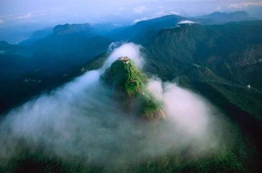
In the picturesque hill region of Sri Lanka, Adams Peak, also known as Sri Pada (or Sacred Footprint), is located next to the little town of Dalhousie (Nallathanniya). Adams Peak, which has a staggering 5,500 steps, has established a reputation as a sacred mountain and attracts a large number of pilgrims because of its spiritual significance. Mountain called Adam's Peak in southwest Sri Lanka. It is situated 11 miles (18 km) northeast of Ratnapura, the Sabaragamuwa province's capital, and is 7,559 feet (2,304 meters) high. The Sri Pada, which translates to "Sacred Footprint" in Sinhala, is a hollow that is 67 inches (170 cm) long and 18 inches (46 cm) broad and looks like the print of a human foot. Buddhists, Hindus, Christians, and Muslims all revere the Sri Pada. Every year, several pilgrims of all religions travel to the top.
The tallest peak in Sri Lanka is Pidurutalagala, not Adam's Peak, but it towers over the surrounding range and resembles a pyramid due to its conical form. Tropical rainforest covers the area around Adam's Peak, and the Peak Wilderness Sanctuary was established as a protection area in 1940. Elephants live there, cut off from the lowlands by the tea farms that surround the sanctuary. Adam's Peak is the source of the Kelani, Walawe, and Kalu, three of Sri Lanka's largest rivers. The summit is notable for being abundant in garnets, rubies, and sapphires and is made of gneiss granite.
𝗥𝗲𝗮𝗱 𝗠𝗼𝗿𝗲:
𝗚𝗼𝗼𝗴𝗹𝗲 𝗠𝗮𝗽:
#AdamsPeakSriLanka#SriPadaya#SriPada#MountainsinSriLanka#SacredFootprint#LordBuddha#GodSaman#NuwaraEliya#Hatton#Dalhousie#CentralProvince#hiking#MistyMountain#Mountainshunting#Sunrise#Viewpoint#travel#travelsrilanka#travelphotography#srilanka#srilankatravel#srilankatrip#srilankatourism#ceylon#paradiseisland#destination#nature#naturelover#VisitSriLanka#BeautifulplacesSriLanka
0 notes
Text
𝐋𝐨𝐭𝐮𝐬 𝐓𝐨𝐰𝐞𝐫 𝐢𝐧 𝐒𝐫𝐢 𝐋𝐚𝐧𝐤𝐚

Lotus tower is the highest tower in Sri Lanka. In Sinhala, Lotus Tower is also referred to as "Nelum Kuluna". Lotus Tower is one of the most well-known tourist attractions in the town of Colombo, Sri Lanka. This tower is the highest in South Asia, the 11th tallest in Asia, and the 19th tallest in the entire globe, standing at a height of 356 meters. It has grown to be one of the top tourist destinations in Sri Lanka and is well-liked by visitors.
The Lotus blossom serves as the design inspiration for this structure. In Sri Lankan tradition, the lotus represents purity and is seen to represent the nation's thriving progress. Two inverted trapezoids will also be used to build the tower foundation, which takes its design cues from the lotus throne. A seamless transition between pink and pale yellow is intended for the tower's hue, which will be accomplished by coating the glass. The tower has a height of 350 m (1,150 ft) and a floor area of 30,600 m2 (329,000 sq ft). It ranks as the 11th tallest tower in Asia, the tallest tower in South Asia, and the 19th tallest tower overall.
𝗥𝗲𝗮𝗱 𝗠𝗼𝗿𝗲:
𝗚𝗼𝗼𝗴𝗹𝗲 𝗠𝗮𝗽:
#LotusTowerSriLanka#NelumKuluna#TallestTowerSriLanka#Colombo#TouristAttraction#Viewpoint#travel#travelsrilanka#srilanka#srilankatravel#srilankatrip#srilankatourism#srilanka🇱🇰#ceylon#paradiseisland#destination#nature#VisitSriLanka#BeautifulplacesSriLanka#PlacestoVisitSriLanka#Travelisland#Spicefood#IndianOcean#picoftheday
0 notes
Text
𝐌𝐞𝐞𝐲𝐚𝐧 𝐄𝐥𝐥𝐚 𝐅𝐚𝐥𝐥𝐬 𝐒𝐫𝐢 𝐋𝐚𝐧𝐤𝐚

Many environmentalists, waterfall aficionados, and members of the general public in our nation are unaware of Meeyan Ella Falls. At the very least, few people even know where it is. This waterfall is situated close to the Ihalakotte train station along the Kandy railway line. Helan-Madiththa, a location on the Alagalla mountain, is the source of the stream that forms the Meeyan Ella waterfall. The waterfall's original course passed through the villages of Walagoda and Thalagolla before merging with Thalagolla Oya. It then fell as a single stream over a rock. The connection between Ma Oya in Boella and Thalagolla Oya follows.
However, the waterfall now divides into two segments with a 50-meter separation. A fascinating tale of how a large waterfall was once split into two smaller ones. To carry products, especially Ceylon tea from Kandy for export during the British Colonial Era, the Colonials built a railway line between Colombo and Kandy. The mid-1800s saw the construction of the railroad line between Polgahawela and Kandy. The Colonials at Alagalla had the difficult task of building the railway over the substantial waterfall Meeyan Ella. As a result, the Colonials were forced to complete the enormous task of digging a tunnel through the Alagalla rock, which was around 304 meters (1000 ft) deep. Instead, they looked for other options, and after examining the location, they came to the conclusion that the only choice was to obstruct the cascade upstream and carve two significant grooves into the rock. As a result, instead of one large waterfall, the water would cascade into two smaller ones. After the job was finished, a horizontal cut through the Alagalla rock measuring about 426 meters (1400 feet) long and five meters (18 feet) deep was made in order to build the railway line, which was finished up to Kandy in 1867. This groove was unable to handle the tremendous rush of water in the stream during severe downpours, and the railway was repeatedly carried away. Due to their difficulty pronouncing "Meeyan Ella," the British Colonials dubbed the waterfall "Meen Galla."
𝗥𝗲𝗮𝗱 𝗠𝗼𝗿𝗲:
𝗚𝗼𝗼𝗴𝗹𝗲 𝗠𝗮𝗽:
#MeeyanEllaFallsSriLanka#IhalakotteTrainStation#Kegalle#Kandy#Alagalla#WaterfallHunting#MistyMountains#waterfallSriLanka#Hiking#Viewpoint#travel#travelsrilanka#travelphotography#srilanka#srilankatravel#srilankatrip#srilankatourism#ceylon#paradiseisland#destination#nature#naturelover#waterfalls#VisitSriLanka#BeautifulplacesSriLanka#PlacestoVisitSriLanka#Travelisland#Hillcountry#WaterfallAdventure#CampingPlacesSriLanka
0 notes
Text
𝐏𝐢𝐦𝐛𝐮𝐫𝐚𝐭𝐡𝐭𝐡𝐞𝐰𝐚 𝐋𝐚𝐤𝐞 𝐢𝐧 𝐒𝐫𝐢 𝐋𝐚𝐧𝐤𝐚

Pimburaththewa Lake, also known as Pimburattewa Tank, is one of Sri Lanka's most popular tourist spots. Polonnaruwa District's Aralaganwila has Pimburaththewa Lake. It is well-liked by the locals as a swimming location. Beautiful vistas of the Polonnaruwa district's lush green trees surround the lovely lake. Pimburaththewa Lake is the perfect location to take a bath if you're visiting Polonnaruwa. The Pimburaththewa Tank is primarily recognized by its lake's water spill design. The water spill is made up of a lot of triangles. There are more than five water spills with triangle designs. It is a must-see location when in Polonnaruwa. Although it is not a waterfall like the one in Polonnaruwa, it appears to be a collection of waterfalls.
𝗥𝗲𝗮𝗱 𝗠𝗼𝗿𝗲:
𝗚𝗼𝗼𝗴𝗹𝗲 𝗠𝗮𝗽:
#PimburaththewaLakeSriLanka#PimburaththewaTank#beautifullakeinsrilanka#PlacestovisitPolonnaruwa#MahaweliProjects#Polonnaruwa#NorthCentralprovince#LakesSriLanka#travel#travelsrilanka#srilanka#srilankatravel#srilankatrip#srilankatourism#ceylon#paradiseisland#destination#nature#naturelover#VisitSriLanka#BeautifulplacesSriLanka#PlacestoVisitSriLanka#Travelisland#Spicefood#IndianOcean
0 notes
Text
Yahangala Mountain in Sri Lanka

In Sri Lanka, Yahangala is a highly well-liked trekking location. Local visitors are more inclined to visit than tourists from other countries. This peak is known as "Bed Rock" by some. It stands at a height of 1220 meters above sea level and is another mountain in the Knuckles Mountain Range. The location is part of Kandy District's Udadumbara Divisional Sectarian region. Additionally, Kandy is 60.2 miles distant (it will take around 1 hour 44 minutes). For people who enjoy hiking, trekking, adventure sports, and camping, this is a fantastic location.
A huge flat region is covered by Yahangala's summit. One of Yahangala's wonders, according to locals, is the absence of large trees. The location is perfect for a campsite and offers breathtaking 360-degree views. From the peak, one can view the "Mahaweli River," "Kehelpathdoruwa," and all three of these landmarks. This object is known as a "yahangala" because of its bed-like appearance. Yahangala is positioned southeast of Knuckles. The topmost part of the Yahangala rock is around two or three acres in size. The entire mountain is exposed to the air, and you may travel both ways. There were no fountains or trees to be found; only broken pieces of stone covered the ground.
𝗥𝗲𝗮𝗱 𝗠𝗼𝗿𝗲:
𝗚𝗼𝗼𝗴𝗹𝗲 𝗠𝗮𝗽:
#YahangalaMountainsSriLanka#MountainsinSriLanka#Knuckles#Camping#MistyMountain#Mountainshunting#Hiking#Kehelapothdoruwa#BedRock#KingRavana#Viewpoint#Travel#Travelsrilanka#Srilanka#Srilankatourism#Ceylon#Paradiseisland#Destination#Nature#naturelover#VisitSriLanka#BeautifulplacesSriLanka#PlacestoVisitSriLanka#Travelisland#HillCountry#Mathale#LonglyVillage#AdventureHike
0 notes