#gis for infrastructure management
Explore tagged Tumblr posts
Visit Tumblr Blog
Explore Tumblr blogs with no restrictions, modern design and the best experience.
Last Seen Tumblr Blogs


Fun Fact
There are dozens of funny blogs to kill time on Tumblr.
Text

Enhancing Gas Pipeline Management with GIS: Key Benefits and Applications
In the energy and utilities sector, gas pipeline management is complex, requiring precision, safety, and a clear strategy for both existing infrastructure and future expansion. Geographic Information Systems (GIS) have revolutionized pipeline management by providing a spatially accurate, data-rich view of assets. From asset management and leak detection to route planning and demand forecasting, GIS is becoming indispensable for gas companies. This blog delves into the ways GIS transforms gas pipeline management, delivering benefits across safety, efficiency, cost-saving, and planning.
#benefits of using gis for gas pipelines#ensuring gas pipeline safety with gis tools#gas network analysis#gas pipeline asset management#gas pipeline gis mapping services#gas pipeline leak detection using gis#gas pipeline management in gis#gas pipeline mapping software#gas pipeline monitoring tools#gas pipeline risk assessment#gis applications in energy sector#gis for gas pipeline monitoring#gis for infrastructure management#gis in oil and gas industry#gis pipeline maintenance software#gis pipeline monitoring system#gis pipeline route planning#gis software for gas pipeline route optimization#victoryofgoodoverevil#gis solutions for pipeline maintenance and monitoring#gis-based pipeline integrity management#pipeline data management#pipeline geographic information systems#pipeline management solutions#remote sensing for gas pipelines#spatial analysis for gas pipelines#spatial data for gas pipelines
0 notes
Text
I'm taking over management of a public informational web map for a small local government. The guy who created it over a decade ago was good with the science/analytical side of GIS but was by his own admission not great a creating an easy-to-read map. I mean, you click on something and the popup label will read "wm_NP3: JXY209". So we're going over the map, I'm talking about some of the changes I'll be able to make like more obvious labels, and he says "oh, don't do that for everything."
"Why not?"
"Some of that's critical infrastructure, we don't actually want all that information public."
His security system was to leave the default labeling for everything and hope that the sensitive information was confusing enough that only the people who needed it for legitimate purposes would be able to figure it out.

Oh, and when I asked if he kept any metadata that might help me understand his files and labels, he basically responded with, "What's metadata?"

Anyway I will be crying in the corner as I try to decipher the data for dozens of mapping files and track down where they came from. I already found out one of our (intentionally public) data layers was last designed and updated on Windows XP so um. Wish me luck.
65 notes
·
View notes
Text
The Difference Between Low, Medium, and High Voltage Switchgear

Switchgear plays a critical role in the generation, transmission, and distribution of electrical power. It ensures safe and efficient operation by controlling, protecting, and isolating electrical circuits and equipment. But not all switchgear is created equal — low, medium, and high voltage switchgear are designed for different voltage levels and applications.
Understanding the differences between these types is crucial for electrical engineers, electricians, project managers, and anyone involved in power systems. In this article, we break down what sets them apart in terms of voltage range, components, applications, design, and safety considerations.
What is Switchgear?
Before diving into the differences, let’s clarify what switchgear is.
Switchgear refers to the combination of electrical disconnect switches, fuses, or circuit breakers used to control, protect, and isolate electrical equipment. It is essential for de-energizing equipment for maintenance and for clearing faults in the power system.
Classification by Voltage Level

Low Voltage Switchgear (LV)
Voltage Range:
Up to 1,000V AC (typically 400V/690V in 3-phase systems)
Key Components:
Miniature Circuit Breakers (MCBs)
Molded Case Circuit Breakers (MCCBs)
Residual Current Devices (RCDs)
Contactors and relays
Busbars, metering, control panels
Applications:
Residential and commercial buildings
Data centers and office spaces
Light industrial automation
Control panels and motor control centers (MCCs)
Characteristics:
Compact and easy to install
High frequency of operation
Relatively simple maintenance
Often enclosed in modular panels
Standards:
IEC 61439
NEC (National Electrical Code)
Medium Voltage Switchgear (MV)
Voltage Range:
1kV to 36kV (sometimes up to 72.5kV)
Key Components:
Vacuum circuit breakers (VCBs)
SF₆ (sulfur hexafluoride) insulated switchgear
Current and voltage transformers (CTs, VTs)
Protective relays
Grounding switches
Applications:
Electrical substations
Large factories and industrial plants
Railways and airports
Renewable energy farms (wind/solar)
Characteristics:
Higher insulation and safety requirements
More robust protection systems
Often installed indoors or in compact outdoor enclosures
May use gas-insulated or air-insulated designs
Standards:
IEC 62271–200
IEEE C37 series
High Voltage Switchgear (HV)
Voltage Range:
Above 36kV (commonly 66kV, 132kV, 220kV, up to 765kV)
Key Components:
SF₆ circuit breakers
Air blast or oil circuit breakers (older systems)
Gas-insulated switchgear (GIS)
Disconnectors and earthing switches
High-end protection relays and SCADA integration
Applications:
National and regional power transmission networks
Power generation plants
Interconnecting large substations
Critical infrastructure (e.g., large data centers, airports)
Characteristics:
Complex installation and high-cost infrastructure
Requires rigorous safety procedures and specialized training
Often installed outdoors or in GIS (Gas Insulated Switchgear) format
Includes extensive monitoring and automation
Standards:
IEC 62271–100 (HV circuit breakers)
IEEE C37.06
ANSI C37 series
Safety Considerations

Always follow local electrical codes, use personal protective equipment (PPE), and conduct routine maintenance regardless of switchgear type.

Conclusion
Choosing the right switchgear��type is critical for ensuring safe and efficient power distribution. Whether you’re designing a residential panel or a high-voltage substation, knowing the difference between low, medium, and high voltage switchgear helps you make informed decisions about equipment, safety, and performance.
Mastering this knowledge isn’t just good practice — it’s essential for anyone serious about a career in the electrical field.
10 notes
·
View notes
Text
IFC to 3DTiles conversion has evolved to this extent with GISBox
Free on-premise cesium ion alternative
As the next generation of spatial information is used in smart cities, digital twins, infrastructure management, etc., the fusion of BIM (Building Information Modeling) and GIS (Geographic Information System) is now an inevitable trend. However, the barrier of interoperability between systems and formats stands between developers and users.
That’s where GISBox comes in. As a new generation 3D spatial data integration platform, it has the industry’s leading IFC to 3DTiles conversion function, and dramatically accelerates data integration and utilization in the fields of architecture, civil engineering, urban planning, and metaverse.
1 | From IFC to 3DTiles: Technology that fills the last step in “BIM x GIS fusion” IFC (Industry Foundation Classes) is an international standard format for BIM that holds geometric information and attribute data (materials, construction history, management numbers, etc.) of architectural structures. On the other hand, 3DTiles is a lightweight format optimized for real-time display that is used in GIS platforms such as Cesium.
There are structural differences between these two, and the following issues frequently occurred in the conventional conversion process:
✅ Missing metadata: BIM attributes such as materials and specifications are lost during conversion
✅ Performance limitations: If IFC is directly loaded into GIS, the display is heavy and it is not suitable for city-level scenes
✅ Compatibility issues: Problems such as display failure and hierarchy collapse due to differences in IFC versions
GISBox tackles these problems head-on, achieving the industry’s first high-precision conversion + attribute preservation + lightweighting at the same time.
2 | No-code & visualization, a conversion experience that is friendly to non-engineers
Conventional conversion tools require specialized knowledge (GLTF, B3DM, etc.), so the reality was that only a limited number of engineers could use them. GISBox provides a UI/UX that anyone can use, such as:
🖱️ Import IFC files by dragging and dropping
👀 Preview LOD settings, materials, and hierarchy display in real time
🚀 One-click OGC-compliant 3DTiles data output (compatible with Cesium, SuperMap, Mapbox)
🔧 API that can be linked with Python and JavaScript is also provided, allowing developers to automate processing
3 | Supports a wide range of use cases, from architecture to urban scale GISBox’s IFC to 3DTiles conversion is being used in a wide range of fields, from visualization of individual buildings to urban scale:
🏙️ Smart building management Integrate IoT sensor information into BIM models to visualize building interior condition monitoring and maintenance forecasts.
🌇 Urban planning simulation Convert hundreds of IFC building models into 3DTiles at once and use them for evaluations such as visibility analysis and sunshine analysis.
🛤️ Inspection and maintenance of infrastructure facilities
Convert civil engineering structures such as bridges and tunnels into 3DTiles while retaining their construction history. A digital foundation for maintenance.
🕹️ Metaverse construction
By outputting models in lightweight 3DTiles format, they can be quickly deployed in virtual exhibition spaces and virtual factories.
4|GISBox as a common language for spatial information
GISBox’s conversion engine is not just a technical tool.
It is a bridge between the different cultures of BIM and GIS,
and a common language for digital space that connects design, construction, and management.
In Japan’s accelerating smart city concept, architectural digital transformation, and urban disaster prevention and mitigation measures,
GISBox is expected to be the key to realizing the “democratization of spatial data.”
GISBox Official Teams: https://teams.live.com/l/invite/FEAr12sInvEVy4hFQE Official Teams Group: https://teams.live.com/l/invite/FBAFp0pbqhqlpe1BQI
Contact us to get 7-day Team Plan
2 notes
·
View notes
Text
Landscape Architecture: Designing the Perfect Harmony Between Nature and Structure (Campos Brothers Landscaping)
In a world where the balance between natural beauty and urban development is more important than ever, Landscape Architecture plays a pivotal role. It’s not just about making spaces look good—it’s about designing outdoor environments that are sustainable, functional, and enriching for the people who use them.
What Is Landscape Architecture?
Landscape architecture is the discipline of designing outdoor spaces—from parks and gardens to urban plazas and campuses. It blends art, ecology, engineering, and sociology to shape environments that are not only visually appealing but also serve a purpose.
Landscape architects consider everything from topography and climate to soil health and community needs when developing a site.
Key Elements of Landscape Architecture
Site Planning: Evaluating and preparing land for development while preserving natural features.
Environmental Restoration: Reviving natural ecosystems and promoting biodiversity.
Urban Design: Integrating green space into cities for better quality of life.
Stormwater Management: Creating natural drainage systems to reduce runoff and pollution.
Recreational Spaces: Designing parks, playgrounds, and trails that invite public use.
Benefits of Landscape Architecture
🌱 Sustainability
Landscape architecture incorporates green infrastructure and native plantings to reduce energy consumption, water use, and carbon footprints.
🏙️ Improved Urban Living
Thoughtfully designed public spaces promote healthier, more connected communities with cleaner air and accessible green areas.
🏞️ Enhanced Aesthetics
From botanical gardens to elegant courtyards, the visual impact of landscape design transforms how people experience space.
💧 Efficient Water Use
Smart irrigation systems and drought-tolerant plants are essential components that support environmental conservation.
🧘 Mental & Physical Well-being
Natural surroundings have a calming effect and encourage outdoor activity, supporting both physical health and mental clarity.
Applications of Landscape Architecture
Public Parks & Greenways
Commercial Properties
Residential Communities
College Campuses
Healthcare Facilities
Transportation Corridors
The Role of a Landscape Architect
Landscape architects don’t just plant trees and lay out flower beds—they analyze site conditions, collaborate with engineers and architects, and use software like CAD and GIS to plan everything down to the last detail. Their work ensures that outdoor spaces are not only beautiful but also safe, usable, and environmentally sound.
Final Thoughts
Landscape architecture is where creativity meets sustainability. It shapes the way we interact with our environments, improving both form and function. Whether it’s a bustling city plaza or a serene backyard retreat, the principles of landscape architecture help turn vision into reality—connecting people with the natural world in thoughtful, impactful ways.
2 notes
·
View notes
Text
Udaan by InAmigos Foundation: Elevating Women, Empowering Futures

In the rapidly evolving socio-economic landscape of India, millions of women remain underserved by mainstream development efforts—not due to a lack of talent, but a lack of access. In response, Project Udaan, a flagship initiative by the InAmigos Foundation, emerges not merely as a program, but as a model of scalable women's empowerment.
Udaan—meaning “flight” in Hindi—represents the aspirations of rural and semi-urban women striving to break free from intergenerational limitations. By engineering opportunity and integrating sustainable socio-technical models, Udaan transforms potential into productivity and promise into progress.
Mission: Creating the Blueprint for Women’s Self-Reliance
At its core, Project Udaan seeks to:
Empower women with industry-aligned, income-generating skills
Foster micro-entrepreneurship rooted in local demand and resources
Facilitate financial and digital inclusion
Strengthen leadership, health, and rights-based awareness
Embed resilience through holistic community engagement
Each intervention is data-informed, impact-monitored, and custom-built for long-term sustainability—a hallmark of InAmigos Foundation’s field-tested grassroots methodology.
A Multi-Layered Model for Empowerment

Project Udaan is built upon a structured architecture that integrates training, enterprise, and technology to ensure sustainable outcomes. This model moves beyond skill development into livelihood generation and measurable socio-economic change.
1. Skill Development Infrastructure
The first layer of Udaan is a robust skill development framework that delivers localized, employment-focused education. Training modules are modular, scalable, and aligned with the socio-economic profiles of the target communities.
Core domains include:
Digital Literacy: Basic computing, mobile internet use, app navigation, and digital payment systems
Tailoring and Textile Production: Pattern making, machine stitching, finishing techniques, and indigenous craft techniques
Food Processing and Packaging: Pickle-making, spice grinding, home-based snack units, sustainable packaging
Salon and Beauty Skills: Basic grooming, hygiene standards, customer interaction, and hygiene protocols
Financial Literacy and Budgeting: Saving schemes, credit access, banking interfaces, micro-investments
Communication and Self-Presentation: Workplace confidence, customer handling, local language fluency
2. Microenterprise Enablement and Livelihood Incubation
To ensure that learning transitions into economic self-reliance, Udaan incorporates a post-training enterprise enablement process. It identifies local market demand and builds backward linkages to equip women to launch sustainable businesses.
The support ecosystem includes:
Access to seed capital via self-help group (SHG) networks, microfinance partners, and NGO grants
Distribution of startup kits such as sewing machines, kitchen equipment, or salon tools
Digital onboarding support for online marketplaces such as Amazon Saheli, Flipkart Samarth, and Meesho
Offline retail support through tie-ups with local haats, trade exhibitions, and cooperative stores
Licensing and certification where applicable for food safety or textile quality standards
3. Tech-Driven Monitoring and Impact Tracking
Transparency and precision are fundamental to Udaan’s growth. InAmigos Foundation employs its in-house Tech4Change platform to manage operations, monitor performance, and scale the intervention scientifically.
The platform allows:
Real-time monitoring of attendance, skill mastery, and certification via QR codes and mobile tracking
Impact evaluation using household income change, asset ownership, and healthcare uptake metrics
GIS-based mapping of intervention zones and visualization of under-reached areas
Predictive modeling through AI to identify at-risk participants and suggest personalized intervention strategies
Human-Centered, Community-Rooted
Empowerment is not merely a process of economic inclusion—it is a cultural and psychological shift. Project Udaan incorporates gender-sensitive design and community-first outreach to create lasting change.
Key interventions include:
Strengthening of SHG structures and women-led federations to serve as peer mentors
Family sensitization programs targeting male allies—fathers, husbands, brothers—to reduce resistance and build trust
Legal and rights-based awareness campaigns focused on menstrual hygiene, reproductive health, domestic violence laws, and maternal care
Measured Impact and Proven Scalability
Project Udaan has consistently delivered quantifiable outcomes at the grassroots level. As of the latest cycle:
Over 900 women have completed intensive training programs across 60 villages and 4 districts
Nearly 70 percent of participating women reported an average income increase of 30 to 60 percent within 9 months of program completion
420+ micro-enterprises have been launched, 180 of which are now self-sustaining and generating employment for others
More than 5,000 indirect beneficiaries—including children, elderly dependents, and second-generation SHG members—have experienced improved access to nutrition, education, and mobility
Over 20 institutional partnerships and corporate CSR collaborations have supported infrastructure, curriculum design, and digital enablement.
Partnership Opportunities: Driving Collective Impact
The InAmigos Foundation invites corporations, philanthropic institutions, and ecosystem enablers to co-create impact through structured partnerships.
Opportunities include:
Funding the establishment of skill hubs in high-need regions
Supporting enterprise starter kits and training batches through CSR allocations
Mentoring women entrepreneurs via employee volunteering and capacity-building workshops
Co-hosting exhibitions, market linkages, and rural entrepreneurship fairs
Enabling long-term research and impact analytics for policy influence
These partnerships offer direct ESG alignment, brand elevation, and access to inclusive value chains while contributing to a model that demonstrably works.
What Makes Project Udaan Unique?

Unlike one-size-fits-all skilling programs, Project Udaan is rooted in real-world constraints and community aspirations. It succeeds because it combines:
Skill training aligned with current and emerging market demand
Income-first design that integrates microenterprise creation and financial access
Localized community ownership that ensures sustainability and adoption
Tech-enabled operations that ensure transparency and iterative learning
Holistic empowerment encompassing economic, social, and psychological dimensions
By balancing professional training with emotional transformation and economic opportunity, Udaan represents a new blueprint for inclusive growth.
From Promise to Power
Project Udaan, driven by the InAmigos Foundation, proves that when equipped with tools, trust, and training, rural and semi-urban women are capable of becoming not just contributors, but catalysts for socio-economic renewal.
They don’t merely escape poverty—they design their own systems of progress. They don’t just participate—they lead.
Each sewing machine, digital training module, or microloan is not a transaction—it is a declaration of possibility.
This is not charity. This is infrastructure. This is equity, by design.
Udaan is not just a program. It is a platform for a new India.
For partnership inquiries, CSR collaborations, and donation pathways, contact: www.inamigosfoundation.org/Udaan Email: [email protected]
3 notes
·
View notes
Text
GIS In Our Daily Lives
The involvement of Geographic Information Systems (GIS) in our daily lives is pervasive, influencing and enhancing various aspects across different sectors. The integration of GIS into everyday activities has become integral for decision-making, planning, and optimizing resources. GIS helps city planners and transportation experts to provide them with information like maps, satellite pictures, population statistics, and infrastructure data. GIS helps them make better decisions when designing cities and transportation systems that are sustainable and good for the environment.
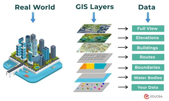
The following points elucidate the notable involvement of GIS in our daily lives:
Navigation and Location Services: GIS provides monitoring functions through the visual display of spatial data and precise geographical positioning of monitored vehicles, whereas GPS provides accurate, clear, and precise information on the position and navigation of a monitored or tracked vehicle in real-time and at the exact location.GIS is at the core of navigation applications and location-based services on smartphones. It enables accurate mapping, real-time navigation, and geolocation services, assisting individuals in finding locations, planning routes, and navigating unfamiliar areas.
E-Commerce and Delivery Services: GIS software is a powerful tool for supply chain network planning. It helps determine the optimal location for distribution centers, warehouses, or other supply facilities. GIS is utilized in logistics and delivery services for optimizing routes, tracking shipments, and ensuring timely deliveries. E-commerce platforms leverage GIS to enhance the efficiency of their supply chain and last-mile delivery processes.
Weather Forecasting and Disaster Management: Many states are using GIS dashboard to monitor the rainfall across the state, on a real-time basis, from the data shared by rain sensors installed at various locationsGIS plays a crucial role in weather forecasting and disaster management. It assists meteorologists in analyzing spatial data, predicting weather patterns, and facilitating timely responses to natural disasters by mapping affected areas and coordinating emergency services.
Healthcare Planning and Disease Monitoring: Geographic Information Systems enable the visualization and monitoring of infectious diseases. Additionally GIS records and displays the necessary information that health care needs of the community as well as the available resources and materials. GIS supports public health initiatives by mapping the spread of diseases, analyzing healthcare resource distribution, and assisting in the planning of vaccination campaigns. It aids in identifying high-risk areas and optimizing healthcare service delivery.
Social Media and Geo-tagging: GIS also helps in geotagging and other location related information in posts, it’s tools can map and visualize the spatial distribution of social media activity. This analysis can reveal trends, hotspots, and patterns in user engagement across different geographic areas. Many social media platforms incorporate GIS for geo-tagging, allowing users to share their location and experiences. This feature enhances social connectivity and facilitates the sharing of location-specific information.
Smart City Initiatives: The Geographic Information System (GIS) offers advanced and user-friendly capabilities for Smart City projects and allows to capture, store and manipulate, analyze and visualize spatially referenced data. It is used for spatial analysis and modeling. It is the cornerstone of smart city planning, enabling the integration of data for efficient urban management. It supports initiatives related to traffic management, waste disposal, energy consumption, and overall infrastructure development.

Education and Research: GIS is increasingly utilized in education and research for visualizing and analyzing spatial data. It enables students and researchers to explore geographic relationships, conduct field studies, and enhance their understanding of various subjects.

Agricultural Management and Precision Farming: Farmers leverage GIS to optimize agricultural practices by analyzing soil conditions, crop health, and weather patterns. Precision farming techniques, facilitated by GIS, contribute to increased crop yields and sustainable farming practices.
Real Estate and Property Management: In the real estate sector, GIS aids in property mapping, land valuation, and site selection. It provides real estate professionals with valuable insights into spatial relationships, market trends, and optimal development opportunities.
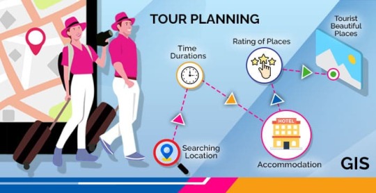
Tourism and Recreation: GIS enhances the tourism industry by providing interactive maps, route planning, and location-based information. It assists tourists in exploring destinations, finding attractions, and navigating efficiently.
The broad and varied involvement of GIS in our daily lives underscores its significance as a technology that not only facilitates geographic data analysis but also contributes to the efficiency, safety, and interconnectedness of modern society. As GIS applications continue to evolve, their impact on daily activities is expected to further expand and refine.
#gis#architectdesign#architecture#city#education#geographic information system(gis)#geographical indication
14 notes
·
View notes
Text
The Goal of Providing Water to Every Home is Becoming a Reality: Col Rajyavardhan Rathore

Water is not just a necessity — it’s a lifeline, a basic right that fuels health, growth, and prosperity. The vision of providing clean and adequate water to every home in India is no longer a distant dream. Under visionary leadership and tireless efforts, this goal is turning into a reality. Col Rajyavardhan Rathore, a staunch advocate for infrastructure development and public welfare, has highlighted the transformative impact of these efforts in communities across the nation.
Water for All: A Foundational Goal for India’s Future

Col Rajyavardhan Rathore’s Commitment to the Cause

Jal Jeevan Mission: Turning Vision into Reality
1. Mission Overview
Launched in 2019, the Jal Jeevan Mission aims to provide functional household tap connections to every rural household by 2024.
Focus: Ensuring adequate and quality water supply.
Execution: Collaborative efforts between the central and state governments.
2. Progress in Rajasthan
Despite being an arid state with challenging terrain, Rajasthan has made significant strides in water accessibility. The implementation of innovative solutions like rainwater harvesting and groundwater recharge has been a game-changer.
Key Milestones Achieved
1. Enhanced Infrastructure
Construction of new pipelines and reservoirs.
Installation of advanced water treatment facilities.
2. Community Participation
Active involvement of local communities in water management has ensured sustainable usage and maintenance.
3. Technological Innovations
Use of technology like GIS mapping and real-time monitoring has accelerated the mission’s progress.
Impact on Rural Communities
The availability of water in rural households has transformed lives in several ways:
Health Improvements: Reduced waterborne diseases.
Economic Benefits: Saved time enables people to engage in income-generating activities.
Women Empowerment: Women no longer need to spend hours fetching water, giving them time for education and personal development.
Challenges and Solutions
Challenges
Limited water resources in arid regions.
Ensuring water quality in remote areas.
Solutions
Promotion of sustainable practices like rainwater harvesting.
Strengthening water testing and treatment infrastructure.
Col Rathore’s Vision for Rajasthan

Partnerships Driving Success
The success of water access initiatives relies heavily on collaboration:
Government Agencies: Coordination between local, state, and central governments.
Non-Governmental Organizations (NGOs): Support for awareness campaigns and capacity building.
Private Sector: Investments in technology and infrastructure.
A Step Toward Sustainable Development
Water access goes hand in hand with other development goals, such as improving sanitation, ensuring food security, and reducing poverty. The progress made under the Jal Jeevan Mission is a strong indicator of India’s commitment to achieving its sustainable development targets.
Water for Every Home — A Transformative Vision
The mission to provide water to every home is reshaping the landscape of rural India, offering hope, health, and opportunities to millions. Leaders like Col Rajyavardhan Rathore continue to champion this cause, ensuring that the dream of water accessibility becomes a reality for all. As Col Rathore aptly stated, “Every drop counts, and every effort matters in building a stronger, healthier nation.”
2 notes
·
View notes
Text
Leading Supplier of Jindal GI ERW Pipe
In the world of construction and infrastructure, the choice of piping material can significantly impact the durability and efficiency of a project. Jindal GI ERW pipes (Galvanized Iron Electric Resistance Welded pipes) have emerged as a preferred choice due to their strength, resistance to corrosion, and ease of installation. As a leading supplier of Jindal GI ERW pipes, Udhhyog is committed to delivering high-quality products that meet the diverse needs of various industries.
What are Jindal GI ERW Pipes?
Jindal GI ERW pipes are manufactured using the electric resistance welding process, which ensures uniformity and strength. These pipes are coated with a layer of zinc, providing excellent protection against rust and corrosion. They are widely used in water supply, gas distribution, plumbing, and structural applications.
Key Features of Jindal GI ERW Pipes
Corrosion Resistance: The galvanization process protects the pipes from rust and corrosion, making them suitable for both indoor and outdoor applications.
High Strength: Jindal GI ERW pipes are known for their tensile strength, making them ideal for high-pressure applications.
Lightweight and Easy to Handle: These pipes are easier to transport and install compared to heavier alternatives, reducing overall labor costs.
Cost-Effective: With their durability and low maintenance requirements, Jindal GI ERW pipes offer a cost-effective solution for various piping needs.
Versatile Applications: They are used in numerous sectors, including agriculture, construction, and industrial applications.
Udhhyog: Your Trusted Supplier
As a prominent supplier of Jindal GI ERW pipes, Udhhyog prioritizes quality and customer satisfaction. Here are some reasons why Udhhyog stands out in the industry:
Quality Assurance: Udhhyog sources its GI ERW pipes directly from Jindal, ensuring that every product meets the highest industry standards.
Competitive Pricing: Committed to providing the best prices in India, Udhhyog ensures that customers receive value for their investments.
Extensive Inventory: With a wide range of sizes and specifications available, Udhhyog caters to diverse industrial needs, ensuring timely delivery and convenience.
Expert Support: Udhhyog’s experienced team is always available to provide expert guidance and assist customers in selecting the right products for their projects.
Flexible Payment Terms: Udhhyog offers flexible credit terms to support MSMEs in managing their procurement efficiently.
#JindalGI#ERWPipes#Udhhyog#PipingSolutions#ConstructionMaterials#IndustrialSupplies#QualityPipes#CorrosionResistant#AffordablePiping#B2BProcurement
5 notes
·
View notes
Text
Sulphur Hexafluoride (SF6)
Introduction
In the realm of high-voltage electrical systems, Sulphur Hexafluoride (SF6) is a cornerstone. Renowned for its exceptional insulating properties, SF6 is a gas that has become essential for the safety and efficiency of various electrical applications. At Prabha Electronics, we understand the importance of high-quality SF6 in maintaining reliable and secure electrical infrastructure. In this blog, we will explore the unique properties of SF6, its diverse applications, and the environmental considerations that come with its use.
What Makes SF6 So Special?
SF6 is a synthetic gas composed of one sulfur atom and six fluorine atoms, giving it remarkable stability and dielectric strength. Its ability to resist electrical discharges and withstand high temperatures makes it an ideal insulating medium for high-voltage equipment. Additionally, SF6 is non-toxic, non-flammable, and chemically inert, ensuring safe usage in critical environments.
Key Applications of SF6 in the Electrical Industry
Gas-Insulated Switchgear (GIS): SF6 is extensively used in GIS, where it serves as an insulator and arc quencher. Its high dielectric strength allows for compact equipment designs, which are crucial in urban areas where space is limited.
Circuit Breakers: In high-voltage circuit breakers, SF6 is used to extinguish arcs that form during the interruption of electric currents. This ensures that the circuit can be safely broken without causing damage to the equipment or posing a risk to personnel.
Transformers: SF6 is also utilized in transformers, providing insulation that allows for efficient energy transfer and enhanced system reliability. The gas's thermal stability ensures that transformers operate safely even under high loads.
Transmission Lines: SF6 is employed in the insulation of high-voltage transmission lines, helping to maintain the integrity and efficiency of power distribution networks.

Advantages of SF6
The widespread use of SF6 is due to its numerous advantages:
High Dielectric Strength: SF6’s dielectric strength is significantly higher than that of air, making it an excellent insulator for high-voltage applications.
Thermal Stability: SF6 remains stable even at high temperatures, ensuring consistent performance in demanding environments.
Compact Design: The superior insulating properties of SF6 allow for the design of smaller, more efficient electrical equipment.
Safety: Being non-toxic and non-flammable, SF6 is a safe choice for various electrical applications when used correctly.
Environmental Considerations
While SF6 offers unparalleled benefits in the electrical industry, it is also a potent greenhouse gas with a long atmospheric lifetime. As such, the industry is actively exploring ways to reduce SF6 emissions through improved handling practices, gas recycling, and the development of alternative insulating gases. At Prabha Electronics, we are committed to supporting these efforts by providing high-quality SF6 that is responsibly sourced and managed.
Conclusion
Sulphur Hexafluoride (SF6) continues to play a vital role in ensuring the reliability and safety of modern electrical infrastructure. Its exceptional insulating properties make it indispensable in a wide range of high-voltage applications. As the industry moves toward more sustainable practices, the responsible use of SF6 will remain a key focus. For more information about SF6 and its applications, visit Prabha Electronics, where we offer top-quality SF6 to meet your electrical needs.
#Sulphur Hexafluoride#SF6#gas-insulated switchgear#SF6 circuit breakers#SF6 transformers#electrical insulation#high-voltage equipment#arc quenching#Prabha Electronics#SF6 applications#electrical industry gas
2 notes
·
View notes
Text
AutoCAD Training in Dehradun
AutoCAD:
AutoCAD, which stands for Computer-Aided Design, is a popular software application used for creating 2D and 3D drawings and designs. It is widely used by architects, engineers, drafters, and professionals in various industries for drafting and designing purposes
CAD Centre is committed to introducing a wide range of comprehensive courses on AutoCad training covering the entire diapason – from autoCad Courses to Training structure to the conservation of training – in a phased manner.
AutoCAD Courses Scope:
AutoCAD courses have a significant scope and demand in various industries due to the software’s widespread use for computer-aided design (CAD) and drafting. AutoCAD is utilised across a range of fields, including architecture, engineering, construction, manufacturing, and more. Here’s an overview of the scope and opportunities associated with AutoCAD courses:
1. Architectural Design
2. Engineering
3. Construction Management
4. Mechanical Transmission
5. Construction Management
6. Manufacturing and Product Design
7. Interior Design
8. Urban Planning and GIS
9. Freelancing and Consulting
10. Education and Training
11. Construction Trades
Future :
Advanced Automation: AutoCAD is likely to incorporate increased automation through AI and machine learning, streamlining design processes and reducing manual work. Enhanced Collaboration: Collaboration features will continue to evolve, enabling seamless real-time teamwork for professionals working on CAD projects from different locations. Cloud-Centric Solutions: A shift toward cloud-based solutions is expected, allowing for easier access, data storage, and project management, fostering flexibility and scalability. Sustainability Integration: AutoCAD will likely place a greater emphasis on sustainable design practices, assisting professionals in creating eco-friendly and energy-efficient designs. Mobile and Web Accessibility: Improved mobile and web accessibility will enable users to access and edit AutoCAD projects on various devices, promoting flexibility and remote work capabilities.
Multiple Skills and the Right Blend:
To succeed in AutoCAD and related fields, you’ll need a blend of technical and soft skills.
Technical Proficiency: Mastery of AutoCAD’s features, tools, and commands is essential for creating accurate and efficient designs.
Problem-Solving Skills: The ability to identify and solve design-related issues is crucial, whether it’s troubleshooting software problems or optimizing designs for efficiency.
Attention to Detail: Precision is key in CAD work. Paying close attention to dimensions and design specifications ensures high-quality output.
Communication Skills: Effective communication is vital for collaborating with team members, clients, and other stakeholders to understand and convey design requirements.
Adaptability: As CAD technology evolves, being adaptable and willing to learn new features and techniques is essential to stay relevant in the field.
Job Fields & Roles:
AutoCAD skills open doors to diverse career prospects and job roles, including: Architectural Drafter: Creating detailed architectural plans and drawings for construction projects. Civil Engineer: Designing infrastructure like roads, bridges, and utilities. Mechanical Designer: Developing machinery and mechanical components. Interior Designer: Planning interior spaces and layouts.
Electrical Engineer: Designing electrical systems and circuits.
Landscape Architect: Designing outdoor spaces and gardens.
CAD Technician: Assisting engineers with technical drawings.
Surveyor: Mapping and land boundary determination.
BIM Modeler: Creating 3D building models for construction.
Construction Project Manager: Managing construction projects.
These roles span various industries, offering opportunities for growth and specialisation. AutoCAD proficiency enhances job prospects in architecture, engineering, construction, and beyond.
Related Courses AutoCAD:
If you’re interested in AutoCAD and want to enhance your skills or pursue a related career, there are various courses available that can help you gain expertise in specific aspects of AutoCAD or related fields. Here are some related courses and areas of study:
AutoCAD Essentials: These foundational courses cover the basics of AutoCAD, including drawing and editing tools, layers, dimensions, and more.
Advanced AutoCAD: Advanced courses delve deeper into AutoCAD’s features, including 3D modeling, parametric design, and customising the software to suit specific workflows.
AutoCAD for Architecture: Specialised courses focus on using AutoCAD for architectural design, detailing, and documentation.
AutoCAD for Civil Engineering: These courses teach how to use AutoCAD for civil engineering projects such as site design, road layout, and grading.
AutoCAD for Mechanical Design: Learn to use AutoCAD for mechanical engineering applications, including machine design, assembly, and manufacturing drawings.
AutoCAD Electrical: Courses in this area focus on using AutoCAD for electrical design and schematics.
AutoCAD for Interior Design: Explore how AutoCAD can be applied to interior design projects, including space planning and furniture layout.
AutoCAD for Landscape Design: Learn how to use AutoCAD for landscape architecture, including site planning and plant design.
AutoCAD Civil 3D: This specialized software within the AutoCAD family is used for civil engineering and land development projects. Courses cover its specific features and functionalities.
AutoCAD Customization: Explore courses on customizing AutoCAD through AutoLISP, VBA, or the .NET API to create custom tools and automate tasks.
BIM (Building Information Modeling): BIM courses teach how to integrate AutoCAD with BIM software like Revit for comprehensive building design and documentation.
CAD Drafting and Design Programs: Courses in CAD drafting and design programs cover the broader field of computer-aided design, including the use of various CAD software tools.
Project Management for CAD Professionals: These courses focus on project management principles and techniques specific to CAD and design projects.
Online Platforms and Tutorials: Online platforms like Udemy, Coursera, and LinkedIn Learning offer a wide range of AutoCAD courses, from beginner to advanced levels.
Certification Programs: Consider pursuing AutoCAD certification programs offered by Autodesk, which can validate your skills and knowledge.
When selecting a course, consider your specific goals and career path. AutoCAD courses are available in various formats, including in-person classes, online courses, and self-paced tutorials, so you can choose the one that best fits your learning style and schedule.
1 note
·
View note
Text
Understanding the Importance of Water Utility Surveys
Water is a fundamental resource that sustains life, and the infrastructure supporting its supply and distribution is a critical component of urban and rural development. A water utility survey plays a pivotal role in ensuring the efficient and sustainable management of water resources.
Learn more at https://www.cyberswift.com/blog/water-utility-solution-detailed-overview/

#3D mapping for water utilities#Digital mapping for water utilities#GIS-based water utility mapping#Hydrographic utility surveys#Remote sensing for water pipelines#Surveying for water utility systems#Underground water pipeline surveys#Utility mapping for water projects#Water distribution network survey#Water distribution system assessment#Water infrastructure surveys#Water leakage detection surveys#Water pipeline mapping#Water pipeline monitoring solutions#Water supply network survey#Water utility asset management#Water utility inspection surveys#Water utility network monitoring#Water utility survey services
1 note
·
View note
Text

In an ever-evolving urban landscape, effective city zoning and mapping design services are pivotal for sustainable growth and development. Gsource Technologies, a leading name in the geospatial industry, offers a comprehensive suite of services that cater to the intricate needs of modern urban planning. With a focus on precision and innovation, Gsource Technologies is your trusted partner for LiDAR to CAD/GIS Maps, Geospatial Services, County Zoning Maps, Zoning Map Creation & Maintenance, and Spatial Data Management & Analysis. Let's delve into how these services contribute to shaping the cities of tomorrow.
LiDAR to CAD/GIS Maps: Gsource Technologies leverages cutting-edge LiDAR technology to convert raw LiDAR data into accurate CAD and GIS maps. This process not only ensures precision but also expedites decision-making in city planning. The resulting maps enable urban planners and government authorities to make informed choices regarding infrastructure development, land use, and environmental preservation.
Geospatial Services: Gsource Technologies' Geospatial Services offer a holistic approach to urban planning. They encompass mapping, analysis, and visualization of geographical data, making it easier to understand complex urban dynamics. From demographic analysis to disaster risk assessment, our geospatial services empower city authorities to make well-informed decisions that enhance the quality of life for residents.
County Zoning Maps: Our County Zoning Maps are tailored to the specific needs of local governments and urban planners. They provide a clear and comprehensive view of zoning regulations within a county, helping authorities manage land use efficiently. These maps are crucial for maintaining order, preventing land use conflicts, and ensuring compliance with local regulations.
Zoning Map Creation & Maintenance: Gsource Technologies specializes in the creation and maintenance of zoning maps. These maps are vital tools for urban planners, architects, and developers, enabling them to visualize and adhere to zoning regulations. By continuously updating and maintaining zoning maps, Gsource Technologies ensures that city planning remains dynamic and responsive to changing needs.
Spatial Data Management & Analysis: In the digital age, data is king, and Gsource Technologies understands the importance of robust spatial data management and analysis. Our services help collect, organize, and analyze spatial data, providing valuable insights for urban development. Whether it's traffic flow optimization or identifying areas for green spaces, our data-driven approach ensures efficient city planning.
Gsource Technologies' City Zoning & Mapping Design Services stand at the forefront of modern urban planning. By offering LiDAR to CAD/GIS Maps, Geospatial Services, County Zoning Maps, Zoning Map Creation & Maintenance, and Spatial Data Management & Analysis, we empower city authorities and planners to make informed decisions that result in vibrant, sustainable, and resilient cities. With precision, innovation, and a commitment to excellence, Gsource Technologies is your trusted partner in shaping the cities of tomorrow.
#gsourcetechnologies#architecturedesigns#engineeringdesigns#zoning#gis mapping#lidar technology#lidarsolutions
2 notes
·
View notes
Text
Top 5 GIS Toolboxes: Unlocking the Full Potential of Geographic Information Systems
Geographic Information Systems (GIS) have become indispensable in urban planning, environmental protection, engineering, and other fields. With advancements in technology, various GIS toolboxes have emerged, helping users achieve more efficient data processing and 3D visualization. This article introduces five top GIS toolboxes to help you choose the best solution for your needs.
1. GISBox
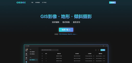
GISBox is a comprehensive GIS toolbox that integrates data processing, spatial analysis, and 3D visualization functions. A standout feature of GISBox is its efficient real-time editing capabilities, such as photogrammetric mesh repairs, riverbed depressions, and terrain alignment, which significantly simplify complex 3D terrain data processing workflows. Additionally, GISBox supports various mainstream publishing protocols, including 3DTiles, Terrain, and WMTS, offering a range of options for different users. Whether for small to medium-sized enterprises or individual projects, GISBox provides an all-in-one solution to efficiently handle GIS data processing and publishing tasks.
Pros:
· Supports multiple data formats.
· User-friendly plugin system for easy extension.
· Powerful 3D visualization and data processing capabilities.
2. QGIS (Quantum GIS)
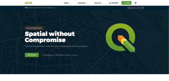
QGIS is an open-source and highly customizable GIS tool widely popular among users globally. Its rich plugin ecosystem caters to various GIS needs, from basic map creation to complex spatial analysis.
Pros:
· Free and open-source, with an active user and developer community.
· Rich in plugins with strong extensibility.
· Highly customizable interface and workflow.
3. ArcGIS
Developed by Esri, ArcGIS is a professional GIS platform with a toolbox that provides hundreds of tools for geographic data analysis and map creation. It integrates data collection, processing, analysis, and visualization, making it the top choice for solving complex geographic problems.
Pros:
· Extensive data processing and analysis tools.
· Integration with other Esri products for a complete GIS workflow.
· Professional technical support and learning resources.
4. Global Mapper
Global Mapper is a comprehensive GIS software that supports a wide range of geographic data formats and powerful data processing functions. Known for its simplicity and affordability, it is suitable for users looking to quickly perform spatial analysis and data visualization.
Pros:
· Supports multiple data formats with robust data conversion capabilities.
· Gentle learning curve for easy onboarding.
· Comprehensive functionality suitable for projects of various scales.
5. SuperMap iDesktop

SuperMap iDesktop is a powerful GIS desktop tool that provides a full suite of tools for spatial analysis, data management, and 3D visualization. It is widely used in industries like urban planning, environmental monitoring, and infrastructure management. SuperMap iDesktop integrates a variety of data formats and supports a range of powerful GIS functions, including advanced 3D terrain modeling, geospatial analysis, and the ability to handle large datasets with ease.
Pros:
Advanced 3D modeling capabilities for creating and analyzing detailed terrain models.
Supports a wide variety of data formats, including raster, vector, and 3D data.
Comprehensive spatial analysis tools and detailed reporting features.
User-friendly interface, suitable for both novice and experienced GIS professionals.
Conclusion
Whether you are a beginner or an experienced GIS user, these toolboxes can provide excellent support for your projects. Software like GISBox and Cesiumlab is highly regarded for its exceptional 3D rendering and data management capabilities, while QGIS and Global Mapper are popular for their flexibility and ease of use. Selecting the right tool based on your specific project requirements and budget will help boost your work efficiency and enrich your geographic data presentations.
1 note
·
View note
Text
How Does Technology Influence Modern Town Planning and Surveying?
Introduction to the Integration of Technology in Town Planning and Surveying
In the 21st century, the fusion of advanced technology with town planning and surveying has revolutionized how urban spaces are conceptualized, developed, and maintained. What once depended on manual drafting, physical mapping, and estimation has now transformed into a digitized, precise, and data-driven process. This evolution is not merely an enhancement—it redefines the future of urban development.

The Role of Geographic Information Systems (GIS) in Town Planning
One of the most impactful technologies in town planning and surveying is Geographic Information Systems (GIS). GIS allows planners to visualize, analyze, and interpret data to understand spatial relationships and patterns.
Data Layering: Multiple data layers, such as demographics, zoning, infrastructure, and environmental constraints, can be overlaid to guide informed decision-making.
Predictive Modeling: GIS tools support simulations to predict future growth, assess land-use efficiency, and plan for infrastructure expansion.
Real-Time Updates: Integrating GIS with live data feeds enables dynamic decision-making for traffic flow, utilities management, and emergency services.
The use of GIS ensures that planners have a holistic, real-time overview of urban environments, resulting in better spatial strategies and resource allocation.
3D Modeling and Visualization in Urban Design
The use of 3D modeling tools like AutoCAD Civil 3D, SketchUp, and BIM (Building Information Modeling) has brought unprecedented clarity to planning and presentation.
Enhanced Public Engagement: Interactive 3D models allow stakeholders and the public to visualize proposed developments, making community involvement more effective.
Design Accuracy: These tools eliminate ambiguities in elevation, topography, and spatial dynamics, reducing costly design errors.
Scenario Testing: Planners can test various design scenarios—such as building placement, street layouts, and infrastructure networks—before execution.
These tools make planning processes more transparent, collaborative, and future-proof.
Remote Sensing and Aerial Surveying with Drones
The integration of Unmanned Aerial Vehicles (UAVs), commonly known as drones, has dramatically enhanced surveying accuracy and efficiency.
High-Resolution Mapping: Drones can capture ultra-high-definition aerial imagery used to create accurate topographic maps.
Time and Cost Efficiency: Surveying large or inaccessible areas with drones is significantly faster and more affordable than traditional methods.
Change Detection: Ongoing drone surveys can monitor environmental or structural changes over time, aiding maintenance and sustainability planning.
Remote sensing via drones allows for continuous, non-intrusive monitoring of urban development and land-use change.
Smart Technologies in Urban Planning
With the rise of smart cities, digital technologies are now central to town planning.
IoT (Internet of Things): Embedded sensors provide data on traffic, pollution, energy usage, and public utilities in real time.
Data Analytics: Big data analytics can detect urban trends and predict future needs, allowing planners to optimize infrastructure and services.
Automation: Traffic lights, waste management systems, and energy grids are being automated for efficiency and sustainability.
This smart integration ensures urban environments are adaptive, efficient, and resilient.
Augmented Reality (AR) and Virtual Reality (VR) in Public Consultation
AR and VR technologies have bridged the gap between technical planning and public understanding.
Immersive Experiences: Citizens can take virtual tours of proposed developments, understanding spatial impact before construction.
Feedback Loop: Interactive AR platforms allow users to leave comments, making public consultations more inclusive.
Planning Simulations: Virtual models simulate sunlight, wind flow, and pedestrian movement to refine planning strategies.
These tools empower communities to participate actively in shaping their environments, leading to more democratic urban development.
Automated Surveying Equipment and Robotics
Modern surveying equipment like total stations, GNSS (Global Navigation Satellite Systems), and laser scanners are now fully automated and integrated with AI.
Precision Mapping: Instruments deliver sub-centimeter accuracy, critical for large-scale infrastructure projects.
Speed and Safety: Automated systems reduce the need for manual labor in hazardous conditions and speed up survey processes.
Data Integration: Real-time syncing with planning databases ensures seamless data updates.
This level of automation brings unmatched precision and safety to surveying practices.
Cloud-Based Platforms and Collaborative Planning
The use of cloud technologies has transformed the collaboration process in town planning and surveying.
Centralized Data Access: Planners, architects, engineers, and municipal authorities can access and update shared data repositories.
Version Control: Teams can track changes and maintain consistency across project lifecycles.
Remote Collaboration: Cloud platforms enable global experts to contribute insights without physical presence.
These platforms foster collaborative, transparent, and accountable urban development processes.
Sustainable Planning through Environmental Tech Integration
Technology aids sustainable town planning by providing tools to assess environmental impact accurately.
Carbon Modeling Tools: These estimate emissions for different planning scenarios, guiding greener choices.
Green Infrastructure Planning: GIS and remote sensing help identify areas for green roofs, parks, and rain gardens.
Smart Water Management: IoT sensors monitor water usage and detect leaks in real-time.
Tech-driven sustainability ensures that urban growth aligns with environmental stewardship.
The Future of Town Planning and Surveying
The future of town planning and surveying is moving towards AI-driven urban design, autonomous data collection, and predictive analytics.
AI Algorithms: These will analyze vast urban data sets to recommend zoning changes, traffic solutions, and public transport routes.
Robotic Surveyors: Autonomous land-based surveyors will soon become standard in difficult terrains and tight deadlines.
Digital Twins: Entire cities will have virtual replicas updated in real-time for advanced simulation and monitoring.
As these technologies mature, they will create more intelligent, responsive, and inclusive cities.
0 notes
Text
Metal Deck Sheet Manufacturer in Delhi NCR – Strength & Innovation for Modern Construction
The construction landscape is rapidly evolving, and the demand for reliable, high-strength building materials is higher than ever. One such essential product used extensively in industrial and commercial construction is the metal deck sheet. If you're searching for a top-quality Metal Deck Sheet Manufacturer in Delhi NCR, this article will guide you on what to look for and why it matters.

What Are Metal Deck Sheets?
Metal deck sheets are high-tensile galvanized steel sheets that serve as permanent formwork and structural components for floors, roofs, and mezzanines in multi-story buildings. These sheets act as a composite with concrete slabs to enhance strength and stability, reduce construction time, and eliminate the need for temporary shuttering.
Advantages of Metal Deck Sheets
Choosing the right decking system can bring numerous benefits:
✅ High Load-Bearing Capacity ✅ Faster Construction Time ✅ Lightweight & Durable ✅ Corrosion Resistance ✅ Cost-Effective ✅ Fire-Resistant Properties ✅ Easy to Handle and Install
These benefits make metal deck sheets a preferred choice for commercial buildings, industrial structures, bridges, and residential high-rises.
Why Choose a Metal Deck Sheet Manufacturer in Delhi NCR?
Delhi NCR is a hub of infrastructure development and industrial growth, and having a reliable metal deck sheet manufacturer in this region ensures:
Quick delivery & logistics support
Customization for local project needs
On-site technical support
Competitive pricing due to proximity
Availability of varied profiles and thicknesses
Local manufacturers in Delhi NCR understand the unique climate, soil, and construction challenges of the region, allowing for better product design and application.
What to Look for in a Reliable Manufacturer?
When selecting a metal deck sheet manufacturer in Delhi NCR, ensure they offer:
✅ ISI and ISO-certified products
✅ High-grade galvanized steel (GI or GL)
✅ Advanced manufacturing machinery
✅ Multiple deck profiles for different uses
✅ Timely delivery and bulk production capacity
✅ Transparent pricing and after-sales support
Leading manufacturers also conduct rigorous quality checks and offer technical consultations for large-scale projects.
Applications of Metal Deck Sheets
Multi-storey buildings
Shopping malls and commercial complexes
Warehouses and factories
Metro and railway infrastructure
Parking lots and basements
Stadiums and auditoriums
Leading Manufacturers in the Region
Delhi NCR is home to several reputed manufacturers who supply metal deck sheets across India. Companies like Color Coated Sheet and other top-tier suppliers are known for their quality standards, on-time delivery, and expert engineering support. Their products meet both domestic and international standards and are widely used in high-value construction projects.
Conclusion
When it comes to modern construction, strength, speed, and efficiency are key. Choosing the right metal deck sheet manufacturer in Delhi NCR ensures your project benefits from superior structural performance, long-lasting durability, and cost-effective solutions.
Whether you're a contractor, architect, or project manager, investing in quality metal deck sheets from a trusted local manufacturer is a smart move toward safe and sustainable building practices.
0 notes