#plot dynamics 365 record maps
Explore tagged Tumblr posts
Visit Tumblr Blog
Explore Tumblr blogs with no restrictions, modern design and the best experience.
Last Seen Tumblr Blogs


Fun Fact
The most popular pages on Tumblr are about Minecraft, GIFs, and David J. Peterson.
Text
1 note
·
View note
Text
MappyField 365: Leveraging Google Maps for Precision and Efficiency in Dynamics 365 CRM

The US alone had 24.7 million downloads of Google Maps in 2022. The data clearly shows the popularity and inclination of users toward Google Maps. And its popularity can be seen in the corporate world as well.
Professionals use Google Maps as a CRM mapping solution to locate leads, contacts, accounts, or opportunities and visualize them like never before.
Google Maps in Dynamics 365 can be seen on Dashboards, record forms, while filtering records, to create an optimized route, and more.
Dynamics 365 CRM users find it difficult to find a tool that offers Google Maps integration because most mapping tools use Bing Maps as their default mapping solution.
However, Dynamics 365 map offers both Google Maps and Bing Maps integration for its users to plot locations on maps.
There are three significant ways to use Google Maps as your CRM mapping solution:
1. Geocode CRM records on Google Maps
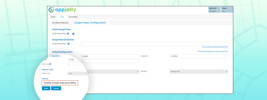
Google Maps gives the most accurate latitude and longitude. Thus, while plotting the data on map, you will have the most accurate results.
We also have a detailed blog on how to configure Google Maps in MappyField 365 and how you can geocode locations.
2. View CRM records on Google Maps

MappyField 365 lets Dynamics CRM users visualize their data by placing entity records on a map. It provides a series of actions that can be performed on plotted records. The actions usually performed on a Dynamics CRM entity record are available from within the map, like add to marketing list, send email, etc.
3. Route Optimization using Google Maps
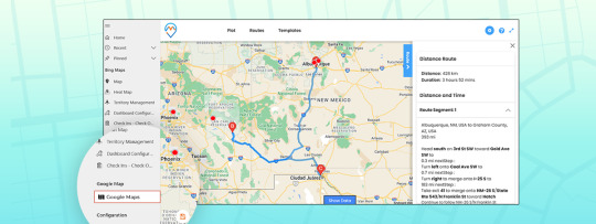
The purpose of optimizing routes is to reduce traveling time and distance. What could be a better option than Google Maps? None!
MappyField 365 lets you add routes and navigate directly to Google Maps. If you want to learn how you can do it, we have a detailed blog explaining how to configure it.
If you wish to use Google Maps for geocoding locations, data plotting, or while optimizing routes, MappyField 365 got you covered. Use Google Maps for Dynamics 365 CRM using MappyField. Contact our sales team for more information about MappyField and how it uses Google Maps to ease your sales team’s life at [email protected]. If you want to have a real time experience of this, book a demo with us.
Click here to book a demo
All product and company names are trademarks™, registered® or copyright© trademarks of their respective holders. Use of them does not imply any affiliation with or endorsement by them.
The Article is originally published on:
https://www.appjetty.com/blog/google-maps-dynamics365-crm/
0 notes
Text
Sales Territory maps dynamics 365
Sales Territory management is the key to increase overall sales and reduces costs for an organization. Sales Territory plan gives a framework to estimate sales potential, set goals and assist your Sales Team to reach targets. Maplytics a Preferred/5 star rated app assists organizations globally for territory management in Dynamics 365 CRM the smarter way. Sales managers can create Sales Territories within Dynamics 365 CRM in Maplytics by visualizing data straight on a map to maximize the productivity of their Sales Team. Dynamics 365 CRM users can plot existing territories and edit them to get the correct territory distribution. Users can also visualize their sales territories and records belonging to them on the map within Dynamics 365 CRM. Download Maplytics now for smart Territory Management within Dynamics 365 CRM.
0 notes
Text
How to Set Navigation App on User Level from Dynamics Mapping Tool
Dynamics CRM has Bing Maps integrated by default. But there are certain limitations when it comes to navigating using Bing Maps inside of Dynamics CRM. To overcome these limitations and achieve more from your Dynamics CRM, you can invest in a Dynamics Mapping tool that allows you to plot records on a map, visualize data with heatmaps, and manage your territories more effectively.
Not only that, but you can also find the shortest paths to cover more clients and meetings in a shorter period of time. And with the right app for navigation, your on-field sales reps can work more effectively.
In this blog, we are going to show you how to set a navigation app like Google Maps, Apple Maps, or Waze on a user level using the Dynamics Mapping tool. Further, we’ve also demonstrated how one can generate navigation links to go about their day.

For the demonstration purpose, we’ve taken Quick Maps but you can browse around on MS App Source and find a suitable Dynamics 365 map integration.
Step 1: Navigate to Map
If you are using old UI (Classic view):
Find the “AppJetty” tab from the header menu, navigate to Quick Maps and then click on Map.
If you are using Unified view:
You can find the ‘Quick Maps’ App by clicking on the Dynamics 365 option.
Step 2: Select any one(Google/Waze/Apple) from the configuration
- Click on the “Map Configuration Details ” option and select the user (a record) for whom you want to set the Navigation Map.
- You can set navigation maps at an individual level i.e. for one user you can set Google Maps while for another user, you can set Waze Map and so on.
- You can also set the Navigation Map based on the devices i.e. Google Map for Android and Apple Maps iPhones/iPads.
Based on the selection in the user configuration detail for ‘Navigation Via’, the navigation link will be generated from the Quick Maps, and by clicking on it, the user will be redirected to the respective App.
Step 3: Navigate to the Maps page and select the Entity.
- By clicking on the Maps, you will be navigated to the Quick Maps page.
- Select the Entity & its view. You can also select the multiple entities if you want.
The data will be plotted on the Map as per the selection of the Entity(s).
Step 4: Insert the Origin and Destination
After plotting the data on the maps, you can add the locations in two ways:
- Manually: Click on the “Direction” tab. From here, you can insert the starting & ending locations by inserting the address manually in “From” and “To” edit boxes.
- Via pushpins: By clicking on any Pushpin, the details of that records will popup. You can set the directions by selecting the “Add to Origin” option and the final destination by selecting “Add to Destination” respectively.
After selecting origin and destination, both locations automatically gets inserted in the “Directions” tab.
- Now click on the Go button for directions on the map. You will get turn-by-turn directions of inserted locations.
The multiple locations selection option is also provided if you want to cover 2-3 clients in a single day.
Step 5: Generating Navigation Links
- After the route is plotted on the map, click on the navigation icon to get the link of the plotted route.
- If you have selected multiple locations, you will get more than one link.
- This will open “Navigation Links” popup with direction links generated from waypoint A-B, B-C, so on.
- By clicking on the links from the Dynamics Mobile/Tablet App, you will be redirected to the relevant Maps app as per the selection of Navigation Map in Map configuration details.
Therefore, the admin user can select any Navigation Map option from Google Maps, Waze, or Apple Maps. This makes it easier for the reps to access the links and make it on time for appointments and meetings.
Source:https://www.appjetty.com/blog/how-to-set-navigation-app-on-user-level-from-dynamics-mapping-tool/
0 notes
Link
Maplytics is one of the leading Certified for Microsoft Dynamics 365 (CfMD) geo-analytical map visualization tool which integrates with Bing Map that helps businesses visualize their CRM data on a map. Maplytics allow users to plot the data based on location, region, drawn shapes, territories and saved templates on map within Dynamics 365 CRM. Users can plot single or multiple entities and view combinations and further categorize the data based on the field attributes of the entity. The users can configure the field attributes categories and choose pushpin shape and color for each category. Users also have the option to perform Proximity/Radius Search based on Distance (single or multiple) and time to find nearby Dynamics CRM entity records in the defined radius.
#Dynamics CRM Bing Maps#Map Dynamics 365#Dynamics CRM Maps#Maps Integration Dynamics CRM#Dynamics CRM Maps Integration
0 notes
Text
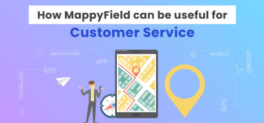
How MappyField can be useful for Customer Service
We all have once come across this quote from mathematician and statistician John Tukey,
“The greatest value of a picture is when it forces us to notice what we never expected to see.”
Tools have made data visualization even easier. It lets you see the bigger picture. In a few clicks, you will have analyzed data on the screen which makes more sense than the thousands of records in your CRM.
Data visualization is of utmost importance to strategize your next move or mishaps, if any!
As we said, tools have made all this easy.
One such tool is MappyField. It is a powerful geo-mapping plugin that integrates with your Dynamics 365 CRM and helps you visualize CRM data in map view.
The geo location mapping plugin is a boon for businesses which includes in-person customer services. It simplifies data visualization, route optimization, live tracking, and much more.
If you are not using a mapping plugin, you might have faced the below-listed challenges.
Lack of Visibility
The major challenge if you have an on field sales team is you don’t know the current status of any tasks that are going on.
1. On-field team
It is hard to get information about all the ongoing on-field activities. For example, if you want to know whether your agent has met client X, you have to either call your team member or drop an email to ask them to share the details of the meeting.
This process is not very feasible. Sales representatives will have to answer calls and reply to emails for every small update. This will consume a lot of their time. On the other hand, managers have to wait for the agent’s replies.
2. Ongoing activities
If managers want to have visibility on completed and remaining appointments, they cannot see the current day status because agents add their work report at the end of the day.
There is no way to keep track of ongoing activities, whether any appointments are postponed or canceled, etc.
Unpredictable Routes
Sales reps have to manually add location details to apps and find the route to the desired location. It is tedious and time-consuming. If there are any manual errors while entering the address details, they might end up at the wrong place.
They might even miss their meeting. And so, the productivity of sales reps is affected without an optimized route.
Undigitized Data
Managers have no track of how many hours their on-field team was working, when they are on break, in a meeting, traveling, etc. There is no visualization of ongoing appointments.
Sales reps will have no proof of work without a tool which makes it harder for their managers to evaluate their performance and make changes in the strategy.
Unplanned Cancelation
Sales rep’s time is wasted when any appointment is canceled or postponed to some other time. The time for the meeting is wasted because they don’t know whether there are any other clients in the neighborhood to make new appointments and utilize time.
How Mappyfield can help you overcome these challenges
Mappyfield was designed keeping in mind the day-to-day challenges of the sales team. We have dived its functionality into two views:
1. Web View
Your business offers home cleaning services. Customers will book an appointment with you using the meeting link that can be shared on all platforms. Once the appointment is confirmed, an agent will be assigned to them. That particular agent might have 5 other appointments as well. After you have assigned your agents, MappyField will help you streamline your next move.
Based on the number of requests agents receive, Dynamics 365 map will help you plot a route that includes all the customer locations they have to visit. The suggested route will be the shortest of all. The link to the entire route is sharable via email.

The managers can view the live location of the onfield agents, whether the agent is following the pre-decided route, and the order of clients to meet. MappyField will plot both routes on the map for the viewer to have a clear visualization of what is going on.


To keep track of meeting timings, whether it happened on time or was skipped, everything is now trackable. MappyField has a check-in/check-out feature that works on a technology called geofencing. So, when your agent reaches the customer location, MappyField will detect that your agent is within the defined radius. This means the agent has reached the client’s location, and they will be auto-checked in. Once they leave the location, MappyField will auto-check them out for that particular meeting. But when the auto check-in and check-out is disabled, manual check-in and check-out will work. So if by any chance they reach the location late, they have to manually submit the request for late check-in along with the reason. The request will be in pending status, and the managers have to approve the request.

Their check-in timings, the duration of meetings, and the notes attached to the meeting can be seen in real-time. As a manager, you will have a clear visualization of all on-field activities.
Last but not least, in the web view is the heat map. To have clear insights into recurring customers, lost customers, revenue, etc., heat maps can help you visualize all this data. With a varying density of colors based on the data, you will know which areas are performing best and which ones are not.
2. Mobile App
To track all the activities, MappyField’s mobile app will ensure your agents have all the necessary information to reach the client’s location, manage reports, and more.
Using MappyField’s mobile app, agents can view their daily schedules. It will have detailed information on clients, timings, routes, etc.

The app will plot the route to the client’s location, so they don’t have to worry about the unknown location while visiting regions for the very first time. Agents can start navigation via Google Maps and Bing Maps.

The agent’s live location is constantly tracked. All this data is accessible to managers. It becomes easy to evaluate performance, manage schedules, extract the latest information, and much more.

Thus, you can definitely improve the quality of work and increase the productive hours of your team with MappyField. In case of any doubt or question, feel free to contact our sales team at [email protected]. All product and company names are trademarks™, registered® or copyright© trademarks of their respective holders. Use of them does not imply any affiliation with or endorsement by them.
The Article is originally published on:
https://www.appjetty.com/blog/mappyfield-useful-customer-service/
0 notes
Text
Less Talked Features of MappyField & Why you Need Them

We are here to brief you about some interesting features of MappyField. We often talk about the major features of location mapping tools like route optimization, proximity search, data plotting, etc. But there is more to it. It is comprised of so many features that improve your team’s productivity.
If you are new and don’t know MappyField and how it can help you or your team, we suggest you go through this blog – Conversation between two sales VP. It is a conversation between two sales VPs where they share challenges and how to overcome those. In the end, you will get an overview of MappyField, its top 5 features, and how it can actually help you.
Let’s learn about MappyField’s other features and what they have for you.
Activity Management
As you might already know that the map shows all the accounts that we have in our Dynamics 365 CRM. So, if you wish to assign these accounts to your team to schedule an appointment with those clients or maybe assign some task related to those accounts, you can easily do so from here.

Create Activity
Hence, after plotting the records on a map, you can select any records from the map. You can perform different activities on that particular record (client), like appointments and tasks. Thus, you can perform any quick actions from the detailed screen.
Moreover, appointment creation is not restricted to you. Your team can also create activities for clients in their territory!
You can assign/reassign records from the map to any team, and they can carry them forward from there. Something like this 👇

Assign Record
Territory Management
Territory management plays a significant role in planning and executing strategies. So, MappyField allows you to search for predefined territories in CRM and also allows you to create one. Thus, while assigning territories to your team from territory management, you can either choose territories from the existing ones or create one. Plus, you can also merge two territories if you want!

Create Territory
Once you are done creating territories, you can assign them to your team members from here itself. So they can see all the records in the territories assigned to them.
Find POI
Once your teams are assigned territories, they will have appointments with the accounts assigned to them. They might want to meet clients at a cafe or restaurant! With MappyField, they don’t have to use any other location apps to search for their point of interest. They can do it with MappyField itself.

POI Image
So, it becomes extremely convenient for my team when they are traveling to unfamiliar places. As we know, POI has multiple attributes like photos of the place, reviews, and ratings which help users in taking better decisions. They can easily find cafes, hotels, gas stations, hospitals, or any other place without leaving the tool! Thus, they are able to find good cafes near the client’s location.
Summary Card
Who doesn’t want to take smarter decisions? With MappyField, it is very much possible. It helps you assign resources smartly. There are times when you want your senior sales reps to handle any crucial clients, or maybe you want your best team to target the high-performing territory and bring the maximum sales!
For that, you will require information like the total number of accounts in the territory, total revenue, income, etc., to assign territories based on these numbers.

Summary Card
It helps you assign the territories in a better way with the feature called Summary Card. Once you choose a specific territory, it will show all the details you want. You can use these details to further distribute work to your team members.
On top of that, Summary Cards support custom fields as well. You have full liberty over what you would like to see on the card. The summary card feature is available for other regions as well and not just territory.
Advanced Filters
It might sound like a tedious task to search for territory or records assigned to a team, but it is not!

Advanced filter Image
With MappyField, you can search accounts with the help of Advanced Search Filters. So,
Either you will select the region you are targeting, and it will ask you to select from the city, state, county, country, or postal codes.
Or you would select the territories that you made earlier!
Or you will draw shapes to highlight the region you want to target, as shown in the image below:
Once you are done entering all the details in the Advanced filter, you can save this template. So next time when you want to see it, you don’t have to enter these details again! Thus, you can save templates for particular territories and accounts that you mostly use.

Save Template Image

List of Saved Templates
So, what do you guys feel about MappyField? Impressive, isn’t it? It is fascinating to believe that there exists a tool that can do so much! It can pretty much remove all the trouble that you have.
If you are managing any of the above-discussed tasks manually, it is high time you upgrade your working process. It will help you streamline your workflow, and at the same time, help you improve productivity to upscale your business.
You can easily contact AppJetty, and we will explain MappyField, a Dynamics 365 map plugin to you in a way that best suits your specific need. We suggest enrolling for a free trial so that you have more hand on experience with the tool.
Book My Trial Now!
All product and company names are trademarks™, registered® or copyright© trademarks of their respective holders. Use of them does not imply any affiliation with or endorsement by them.
The Article is originally published on:
https://www.appjetty.com/blog/dynamics365-mapping-tool-features/
0 notes
Text
How to Approve/Reject Pending Check-in/Check-out in MappyField 365

Earlier, field agents could check in and check out for the appointment using Dynamics 365 map plugin. But now we are adding one additional feature named pending check-in and check-out. With this feature, you will get the list of pending check-ins/check-outs and your user has to add a reason for late check in. Here is how this feature works.
=> First, go to the Map > Plot and select the Entity, such as appointments. Now click on the “Search” button, and the Appointment will be plotted on the map. Now, Click on any appointment pin and click on the Check-in button from the right panel.


=> If the user checks in the appointment late, then they need to add a reason for the late check-in.


=> If Check-in is pending, then users will get the error message when they try to check out.

=> Admin can approve or reject the pending check-ins by navigating to the Check In-Check Out tab.
You have to select the Pending Check-In view. Here you can see all the pending check-ins.


=> Admin has two ways to approve or reject pending check-in.
First is to select the pending check-in and click on the Approve or Reject button. Here admin can perform this action on bulk data.

The second way is to open the record in Edit mode and select the status manually in the Check-In Status field.


=> All the approved check-ins will be shown in the Approved Check-Ins view.

The same flow will work for the pending checkouts. You will get all the views like Approved Check In/Check Out, Rejected Check in/Check Outs, Pending Check in/Check out, etc.
All product and company names are trademarks™, registered® or copyright© trademarks of their respective holders. Use of them does not imply any affiliation with or endorsement by them.
This Article is originally published on:
https://www.appjetty.com/blog/check-in-check-out-in-dynamics365-map/
0 notes
Text
Maps Dynamics 365 CRM
Maplytics™ is an advanced mapping and data visualization tool for Microsoft Dynamics 365 CRM. It provides Territory Management, Appointment Planning, Routing, Radius Search and much more with support for PowerApps (CDS). Maplytics supports all Dynamics 365 deployment models for Dynamics CRM 2011 and above as well as native Dynamics 365 App for Phones and Tablets. Below are the features you can avail with Maplytics • Sales Territory Management: Geographically manage and align sales territories, perform binary operations on shapes, regions or territories on map. Assign multiple territories to a record. • Auto Scheduling: Create an automated optimized schedule for multiple days on field including routes to follow each day based on details entered by user and also create activities for the same • Check-In/Check-Out: Enable Check-In/Check-Out for field reps on site of visit with the option of Geofencing • PCF control: User can add components on fields or grids within Dynamics CRM to view the respective records on the map within the record form or the entity grid • Overlay: View records, shape files and existing territories together on map. View Census Data as existing Overlay feature. • Proximity Search: Search records for a location based on radius or time with shortest travel and line of sight distance. • Route Optimization: Optimize routes, find nearby records along the route and points of interest like Coffee Shops, Gas station, etc. • Customizable Pushpins & Tooltip Cards: Plot desired icons for pushpins for seamless visual analysis. Call to action buttons on Tooltip cards for quick actions. • Security template: System admin and Maplytics admin can provide selective access of actions to users • Marketing Management: Create geographically targeted Marketing Lists for personalized and relevant promotions, marketing campaigns and events • Mass Actions: Add to Route, Save Data, Schedule Appointments, Send Emails and more for records plotted on map • Summary Card: Get aggregated information for enclosed area on map for quick analysis • Layer Menu/Download Map: Show/hide layers plotted on map to toggle between them and Download the map as image visible on screen • Mobility: Use native Dynamics 365 App for Phones and Tablets to get locational insights • Heat Map Visualization: Analyze density of CRM data on map for insights through pie/column charts • Real-Time Tracking: Managers can now track the location of Field Service Reps when on field in real time within Dynamics 365 Field service. • Land Area Mapping: Define the area of land as agricultural, residential, commercial properties and visualize the same on the map. • Territory Assignment Rule: Maplytics Admins and Managers can create simple/advanced rules based on which territories will be assigned to the records as per the required conditions.
0 notes
Text
Optimized Route Dynamics 365
Maplytics provides a comprehensive route planning and management capability. Users can add the data points to a route individually using the contextual menu or simultaneously using the 'Add to Route' mass action. The user has several options like selecting whether the route should be optimized for shortest distance or time and whether to display live traffic data on the map, etc. Redirect to Google Maps: Users have the option to save and share the route with other users and access it on Dynamics 365 App for Mobile and Tablets for turn by turn navigation and redirection to Google Maps or Waze app on their mobile device. Along the Route Search: Users can also find the records that are in the distance along the route. For this, users need to add value for the distance and Maplytics will plot all the records that fall in the defined distance along that route.
#Dynamics 365 Route Optimization#MS Dynamics 365 Route Planning Solution#Route Mapping Dynamics 365#Route Map Dynamics 365#Routing Management Dynamics 365#Dynamics CRM Route Finder
0 notes
Text
Dynamics 365 Data Geocoding Bing Maps
Geocoding technique leverages to derive the geographic locations from address information given in the form of description of location; like address, or the name of the place plotting it to a map. Every business organizations deal with the address information and this transformation or derivation is capable of boosting markets.
Geo-location plays a critical role while making business decisions. It can be done by locating clients or customers geographically and analyzing region-based profits, networking, market assessment, target audience, marketing strategies, etc. Geocoding can bring a revolutionary change in the marketing industry.
Wish to analyze Dynamics 365 data geographically on a Map? Maplytics is an integration tool to bulk geocoding Dynamics CRM data on a Bing Maps. The easy and interactive geo-analytical mapping tool helps to geocode records with Bing map effortlessly. There is no limitation on the number of records that can be geo-coded with Maplytics.
#Geocoding Dynamics CRM data#Geocoding Bing Maps Dynamics CRM#Dynamics 365 Data Geocoding Bing Maps#Geo Map tool Dynamics CRM
0 notes
Link
Microsoft Dynamics 365 is a preferred CRM system for organizations around the world to gather, organize and analyze business data. Having the ability to visualize Dynamics 365 CRM data on a map and further perform drill-down analysis with powerful geo-analytical features and tools. Maplytics is one of the leading Certified for Microsoft Dynamics 365 (CfMD) geo-analytical map visualization tool that helps businesses visualize their CRM data on a map with five search options. Maplytics allow users to plot the data based on Location. Users can plot single or multiple entities and view combinations and further categorize the data based on the field attributes of the entity. The users can configure the field attributes categories and choose pushpin shape and color for each category. Users also have the option to perform Proximity/Radius Search based on Distance (single or multiple) and time to find nearby Dynamics CRM entity records in the defined radius.
#Dynamics CRM Bing Maps#Bing maps integration Dynamics CRM#Map MS Dynamics CRM#Map Microsoft Dynamics CRM#Dynamics CRM Map#Dynamics CRM Mapping tool#Dynamics CRM Map Integration
0 notes
Link
Maplytics helps to transform the address of a location to geo coordinates (latitude and longitude). By using Maplytics for insightful spatial analysis, geocoded records in Dynamics CRM/365 can be plotted on a map. To make the process of geocoding with Bing Maps seamless and hassle-free, Maplytics ships with the Geocoding Workflow to geocode Dynamics 365 data for Account, Lead, and Contact entities and OOB or custom entity.
#Geocoding Dynamics CRM Data Bing Maps#Geocoding Dynamics CRM data#Geocoding Bing Maps Dynamics CRM#Geocoding Maps Dynamics CRM#Dynamics CRM Data Geocoding Bing Maps#Dynamics 365 Data Geocoding Bing Maps#Geo Map tool Dynamics CRM
0 notes
Link
Maplytics is an integration solution between Dynamics CRM/365 and Bing Maps which allows plotting all Dynamics CRM records on a map and get the optimized route to attend more meetings in short time by route mapping features.
#Dynamics CRM Route Finder#Optimized Route Dynamics CRM#Dynamics 365 Route Optimization#Route Planning Solution Dynamics CRM#Route Mapping Dynamics CRM#Route Mapping MS Dynamics CRM
0 notes
Link
Maplytics is a premier geo-analytical solution for Dynamics 365. Maplytics utilizes the power of Bing Maps to help businesses around the world plot, plan and analyze Microsoft Dynamics CRM data on a rich and interactive map interface within Dynamics 365. Users can plot any Dynamics 365 data with geo coordinates (latitude and longitude) on a map to analyze and understand the location aspect of the data.
#Geocoding Dynamics CRM Data Bing Maps#Geocoding Dynamics CRM data#Geocoding Bing Map Dynamics CRM#Dynamics CRM Data Geocoding Bing Map#Geo Map tool Dynamics CRM
0 notes
Link
Maplytics is one of the most comprehensive Microsoft Dynamics CRM/365 mapping tool, which integrates Dynamics CRM with Bing Maps. This Geo-analytical tool Geocodes the addresses of entity records and plots them on the map for location-wise analysis and routing. It is an intelligent platform to present analytical dashboards and heat maps, which further help in regional analysis. You can also work on territory management, optimized routing, appointment planning, marketing list creation, etc. and all these capabilities can help organizations to grow productively.
#Bing map integration Dynamics CRM#Microsoft Dynamics CRM Bing Maps#Bing Map Dynamics 365#Map MS Dynamics CRM#Maps Dynamics CRM#Maps Microsoft Dynamics CRM#Map Integration MS Dynamics CRM#Dynamics 365 Map Integration
0 notes