
APRIL (Advanced Pixel Research & Intelligence Lab), Azista's strategic business unit, uses state-of-the-art AI/ML algorithms to meet customer requirements for data processing and analytics. Our earth imaging satellites are capable of supporting various critical applications for civilian and defence purposes. our satellite imagery can help in agriculture, environment, transportation, mining, forestry, navigation, disaster management, urban planning and other government agencies.APRIL specialises in satellite data processing and analytics APRIL works with diverse datasets to deliver actionable intelligence to strategic users and has developed proprietary software in accordance with DIPAC guidelines. Additionally, APRIL offers timely intelligence reports over specified Areas of Interest (AoI).Our first satellite, "AFR," on June 13th, 2023. AFR is a wide-swath medium-resolution remote sensing satellite with various use cases for civilian and defence purposes.
Don't wanna be here? Send us removal request.
Statistics
We looked inside some of the posts by april-azista-space and here's what we found interesting.
Average Info
Notes Per Post
1
Likes Per Post
1
Reblog Per Post
0
Reply Per Post
0
Time Between Posts
5 days
Number of Posts By Type
Text
15
Last Seen Tumblr Blogs


Fun Fact
The Tumblr app for Google Glass was released on May 16, 2013.
Text

Earth Observation Satellite from APRIL
Showcase captures the diverse landscapes of Southern Israel, vividly represented in both False Color and Natural Color composites from our AFR satellite. Using Near-Infrared (NIR) data, the False Colour image highlights the vibrant reds of healthy vegetation. In contrast, the Natural Color image provides a more familiar perspective of the land's natural tones. Key areas such as Sderot, Netivot, Rahat, and the Bitronot Ruhama Reserve stand out, with the contrast revealing agricultural patterns, urban development, and natural features. These dual perspectives offer invaluable insights for monitoring environmental changes, land use, and planning for sustainable growth in this dynamic region. Stay tuned for more stunning views from around the world every week!
For more information contact us : https://www.april.azista.space/
#afr satellite#satellite image analytics#ABA First Runner#Satellite test system#aerospace#defense#aerospace manfacturing#sub system#satellite manfacturing
0 notes
Text
AFR Satellite from APRIL
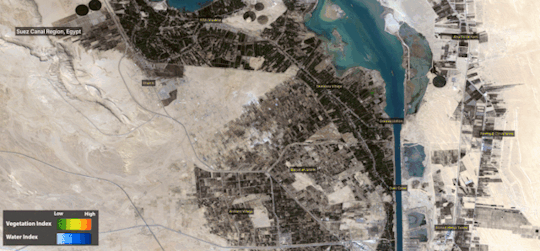
This stunning AFR satellite image showcases the diverse landscape of Al Kibrit, Egypt. Natural color composite image is overlaid with NDVI (Normalized Difference Vegetation Index) and NDWI (Normalized Difference Water Index) masks. The image reveals a captivating story of vegetation health, water bodies, and potential flooding.
The vibrant green hues of the NDVI highlight the lush vegetation, particularly the circular or semi-circular patterns indicative of central pivot irrigation systems. Meanwhile, the deep blue shades of the NDWI reveal the expanse of the Great Bitter Lake and other water bodies, potentially indicating areas affected by flooding.
By combining NDVI and NDWI, we gain a deeper understanding of the region's agricultural practices, water resources, and vulnerability to flooding. This analysis can be used to assess vegetation health, monitor water quality, and support sustainable land management.
Stay tuned for more breathtaking informative images from across the globe every week!
For more information contact us : https://www.april.azista.space/
#afr satellite#satellite image analytics#ABA First Runner#Earth Observation Satellite#satellite test system#geo spatial#water resources#space exploration#space teschnology#space industry#aerospace industries
0 notes
Text

AFR Satellite from APRIL
Captivating image brings you a view of Svalbard, Norway, a remote archipelago in the Arctic Circle, captured by our AFR satellite. This stunning natural color image showcases the rugged terrain, with snow-covered peaks, rocky valleys, and the strategic location of the Svalbard Ground Station of KSAT, nestled near the Svalbard Airport and the town of Longyearbyen. The deep blue and green hues of the surrounding Arctic waters provide a striking contrast to the barren landscape, highlighting the unique beauty of this northern frontier. Svalbard plays a crucial role in satellite communications, climate research, and Arctic exploration, making it a critical hub for science and technology in one of the most remote places on Earth. Can you guess why so? Stay tuned for more extraordinary views from around the world every week!
For more information contact us : https://www.april.azista.space/
#afr satellite#satellite image analytics#ABA First Runner#technology#Innovation#space industry#Earth observation#satellite subsystem#Remote sensing#Space Industry#space technology#satellite imaging
0 notes
Text

Satellite Image Analytics from APRIL
we're excited to showcase a stunning satellite image that provides a detailed view of Taiyuan City, China, through the lens of our AFR satellite using a Near-Infrared (NIR) false color composite. The vivid reds emphasize the dense vegetation covering the rugged mountainous terrain, while the urban sprawl of the city is clearly distinguished, illustrating the sharp contrast between nature and human development. Key features in this image include the Wujishan National Forest Park, Fenhe River, Taiyuan Wusu International Airport, and the towering Hanjiu Mountain. This visualization provides essential insights into the relationship between urban expansion and the surrounding natural environment, which is crucial for sustainable city planning and conservation strategies. Our use of NIR imagery aids in monitoring vegetation health, urban growth, and environmental changes, supporting informed decision-making for ecological stewardship and urban management. Keep an eye out for more breathtaking images from across the globe every week!
For more information contact us : https://www.april.azista.space/
#afr satellite#ABA First Runner#Satellite Image Analytics#aerospace#defense#technology#Remote Sensing#Environmental Conservation
0 notes
Text

AFR Satellite from APRIL
We bring you an awe-inspiring view of St. George, Utah, USA captured by our AFR Satellite using a Near-Infrared (NIR) false color composite. The rich reds highlight the vibrant vegetation amidst the arid desert landscape, while the urban areas and unique geological features of the region stand out in stunning detail. Highlighted in this image are notable landmarks such as the Red Cliffs Desert Reserve, Green Spring Golf Course, and the scenic Sand Hollow Trails. This visualization underscores the contrast between developed areas and natural landscapes, providing valuable insights into urban development and environmental management. Our use of NIR imagery helps in monitoring vegetation health, urban expansion, and environmental changes, contributing to sustainable urban planning and conservation efforts. Stay tuned for more breathtaking views from around the globe every week!
For more information contact us : https://www.april.azista.space/
#afr satellite#earth observation#satellite imagery#remote sensing#AFR#ABA First Runner#Satellite image analytics#AFR Satellite#aerospace manfacturing#satellite imaging#space#space technology#aerospace industries#makeinindia
0 notes
Text

AFR Satellite from APRIL
Feature brings you a vibrant view of Agricultural fields in Colonia Concordia, Uruguay, captured by our AFR Satellite. The intricate patchwork of agricultural fields is beautifully depicted, highlighting the diverse land use in the region. The Uruguay River and the Río San Salvador River gracefully weave through the landscape, with varying shades of green representing different crop types and vegetation health. The image showcases the rich agricultural lands that are vital to Uruguay's economy. This detailed satellite imagery plays a crucial role in monitoring crop health, land use patterns, and environmental changes, providing essential data for sustainable agricultural practices and regional planning. Stay tuned for more breathtaking views from around the globe every week!
For more information contact us : https://www.april.azista.space/
#afr satellite#aerospace#earth observation#satellite imagery#Remote sensing#geospatial#aerospace manfacturing#space industries#aerospace industries#space exploration
0 notes
Text

AFR Satellite from APRIL
we're excited to showcase a stunning satellite image that provides a detailed view of the Xe Kaman River in Laos, vividly capturing the surrounding landscapes through our AFR satellite. The rivers are distinctly visible in different colors due to varying sediment levels and water composition: the Xe Kaman River appears dark blue, while the Xe Xou River displays a lighter shade. As these two rivers merge, there's a fascinating transition where their colors blend, illustrating the confluence of their waters. This change in coloration is a vivid reminder of the dynamic processes at play in natural water bodies and the power of Earth Observation (EO) technology to capture these subtle yet important details. The surrounding bright red areas represent dense vegetation, highlighted using near-infrared (NIR) bands, which underscore the region's agricultural activity and natural greenery. With imagery like this, we enable critical insights into land use, water quality, and environmental changes, supporting sustainable management and conservation efforts. Stay tuned for more breathtaking views from space as we continue to explore and understand our planet from above.
For more information contact us : https://www.april.azista.space/
#afr satellite#ABA First runner#satellite image analytics#aerospace technology solutions#space industry#technology#earth observation#satellite#earth observation satellite
0 notes
Text

AFR Satellite from APRIL
This week's stunning image showcases an archived capture of the vibrant and historical heart of the United States: Washington D.C., captured by our AFR Satellite.🛰️ This image provides a detailed look at the iconic landmarks and intricate cityscape of the nation's capital.
Key Features: • The White House • United States Capitol • The Pentagon • National Mall • Washington National Cathedral • Ronald Reagan Washington National Airport Seasonal Highlights: The Washington D.C. is beautifully adorned with the warm autumn hues of orange and red foliage. The changing leaves of the numerous trees create a picturesque contrast against the urban landscape, highlighting the city's blend of natural beauty and architectural grandeur. The visible patches of orange trees capture the essence of the autumn season, making this a perfect snapshot of the city's seasonal charm. Our AFR satellite captures high-resolution images that are crucial for urban planning, disaster management, and environmental monitoring. The clarity and detail of this image underline the importance of EO satellites in understanding and managing our world.
Stay tuned for more breathtaking images and insights from around the globe!
For more information contact us : https://www.april.azista.space/
#afr satellite#aba first runner#satellite image analytics#technology#satellite test system#innovation#Aerospace#satellite#defense
0 notes
Text

AFR Satellite from APRIL
we bring you an awe-inspiring view of San Francisco Bay, California, captured by our AFR Satellite using a Near-Infrared (NIR) false color composite.🛰️ The striking reds represent the lush vegetation surrounding the bay area, while the detailed urban landscape and varying shades of blue in the water bodies stand out, showcasing the unique blend of natural beauty and urban development. Highlighted in the image are key landmarks such as the bustling Port of Oakland, and the vast San Francisco International Airport. The zoomed-in part of the image shows an aircraft in three different colors (red, green, and blue). These colors represent different times when each band was captured. The distance between the aircraft in each color indicates the time interval between the acquisitions (1 sec and 3 Sec). A similar phenomenon is observed for the speedboats but on a very small scale. Stay tuned for more stunning perspectives from around the world every week! For more information, contact us: https://www.april.azista.space/
#AFR Satellite#ABA First Runner#Aerospace#Satellite Image Analytics#technology#defense#Space Industry
0 notes
Text

Satellite Image Analytics from APRIL
we're excited to showcase a stunning False color composite image, captured by our AFR Satellite of the beautiful La Paz, Mexico region! 🛰️ This captivating image showcases La Paz, Mexico, through the lens of our Earth Observation satellite using a Near-Infrared (NIR) false color composite. The vibrant reds highlight the lush vegetation, while urban areas and water bodies create a striking contrast, painting a vivid picture of the region's diverse landscape. The Image highlights the beautiful city of La Paz, La Paz International Airport, Aura Solar Plant, one of the largest solar plants in Latin America and Cerro Atravesado a prominent geological feature in the city. Our use of NIR imagery helps in monitoring vegetation health, urban sprawl, and environmental changes, providing crucial insights for sustainable development and environmental conservation. Stay tuned for more stunning views from around the world every week!
For more information, contact us: https://www.april.azista.space/
#Satellite#Aerospace#Satellite image analytics#afr satellite#ABA First runner#defense#technology#Earth observation#Mexico#Azista BST Aerospace#ABA#Space industry#Space technology#aerospace industries#make in india
0 notes
Text

Satellite Image Analytics from APRIL
we're excited to showcase a stunning satellite natural colour composite image, captured by our AFR Satellite of the beautiful region around Acequilla, Madrid, Spain!🛰️ In this detailed view, you can see the diverse landscape featuring the towns of Azuqueca de Henares, Albolleque, and Los Santos de la Humosa, with their vibrant agricultural fields and rugged terrain. The image beautifully highlights the elevation differences and plateaus in the region, showcasing the intricate balance between natural and urban environments. The varying colours and shadows indicate changes in elevation, offering a clear depiction of the region's topography. Stay tuned for more breathtaking views from above!
For more information, contact us: https://www.april.azista.space/
#aerospace#Satellite imagery#Tech innovation#Earth observation#AFR Satellite#Aerospace#Defense#satellite#ABA First Runner#Satellite image data analytics#Space Industry#Remote Sensing#Topography#Satellite#Technology
0 notes
Text

Satellite Image Data Analytics from APRIL
Check out this mesmerizing GIF showcasing the salt pans near Gujarat, India! Each frame represents different band combinations captured by our satellite. Witness the stunning transformation and insights provided by our advanced imaging techniques. Explore the power of satellite imagery and the beauty of our planet's surface.
For more information, contact us: https://www.april.azista.space/
0 notes
Text

ABA First Runner (AFR) from APRIL
AFR Satellite has imaged the vibrant city of Ahmedabad, Gujarat, India! From the historic Sabarmati River winding through the heart of the city to the bustling urban landscape, this snapshot showcases the dynamic growth and rich heritage of one of India's most important cultural and economic hubs. Please note that Ahmedabad hosts several space organizations like INSPACE, ISRO’s SAC, three Azista facilities: our satellite factory, Azista BST Aerospace, Azista Aerospace and AEG, along with several other startups The city is a rising space hub, with its highly skilled human resources and state-of-the-art infrastructure for space-systems. Highlights: • The iconic Sabarmati Riverfront • Major landmarks and bustling markets • Narendra Modi Stadium • Sardar Vallabhbhai Patel International Airport • Expansive green spaces and urban planning Stay tuned for more fascinating views of cities around the world as we continue to explore our planet from above.
For more information, contact us: https://www.april.azista.space/
#april#afrsatellite#abafirstrunner#aerospace#defense#satellite#technology#tech#computing#ABA#ABAFIRSTRUNNER
0 notes
Text

AFR Satellite from APRIL
We are thrilled to report that its performance continues to exceed expectations and improve each day. Here's to many more years of groundbreaking imagery and exploration! Stunning New Image of Ismailia, Egypt! Captured by AFR Satellite🛰️ We are excited to share a breathtaking false-colour composite image captured by our latest Earth Observation satellite AFR, showcasing the vibrant and intricate agricultural landscape of Ismailia, Egypt. This image utilizes the Near-Infrared (NIR) band to highlight the subtle variation in vegetation. The picture highlights the Al Shabab Power Project’s Energy infrastructure, Solar Panels and Al Salhiya Road connecting various agricultural zones. Our cutting-edge technology allows us to capture detailed and dynamic images, providing valuable insights into land use, environmental changes, and urban development. This image exemplifies how satellite imagery can aid in monitoring agricultural practices, planning infrastructure, and promoting sustainable growth. For more information, contact us : https://www.april.azista.space/
0 notes
Text

Satellite Data Processing and Data Analytics with AI-Based Intelligence Solutions.
APRIL (Advanced Pixel Research & Intelligence Lab), Azista's strategic business unit, uses state-of-the-art AI/ML algorithms to meet customer requirements for data processing and analytics. Our earth imaging satellites are capable of supporting various critical applications for civilian and defence purposes. our satellite imagery can help in agriculture, environment, transportation, mining, forestry, navigation, disaster management, urban planning and other government agencies.
APRIL specialises in satellite data processing and data analytics. APRIL works with diverse datasets to deliver actionable intelligence to strategic users and has developed proprietary software in accordance with DIPAC guidelines. Additionally, APRIL offers timely intelligence reports over specified Areas of Interest (AoI).
Our first satellite, "AFR," on June 13th, 2023. AFR is a wide-swath medium-resolution remote sensing satellite with various use cases for civilian and defence purposes.
For more information, contact us : https://www.april.azista.space/
#afr satellite#satellite data analytics#satellite imagery analytics#satellite image analytics#satellite image analysis system#test and automation solution#signal processing company
1 note
·
View note