
Tips and tricks for #GIS. Video tutorials for #QGIS, #ArcGIS, #Python and remote sensing.
Don't wanna be here? Send us removal request.
Statistics
We looked inside some of the posts by burdgis and here's what we found interesting.
Average Info
Notes Per Post
26K
Likes Per Post
15K
Reblog Per Post
12K
Reply Per Post
9
Time Between Posts
2 months
Number of Posts By Type
Text
4
Link
2
Photo
2
Video
2
Last Seen Tumblr Blogs


Fun Fact
Tumblr’s reach among the 26-to-35-year-olds in the US is 11%.
Text
Okay so as you all know I’m extremely cool and clever and also a published scientist, so let me tell you about my latest research.
In the Legend of Zelda: Breath of the Wild, the continent of Hyrule is one of the biggest open-world maps ever created, even beating games like Skyrim and the Witcher. But, HOW BIG?
Obvs it’s very hard to get a precise size because the in-game map does not have a scale bar (terrible map skills from that cartographer). HOWEVER, if you climb the Ridgeland Tower there’s a guy up there who is a weeaboo for the Rito, who begs you to glide for him in the name of “research” (what a fucking dweeb am I right?) If you do so, he tells you how many metres you’ve flown before landing. This includes if you simply step off the tower and plummet to the ground in a straight line, and happily for my in-game ankles, the tower is surrounded by water to cushion the many landings I made to bring you this information.
Ten drops gave me a mean average height for the tower at 63.83, median 64.2, so I’m taking it as 64 for ease of Maffs.
For a flight from the tower, I picked a strip of land on the same contour line as the tower base and then flew along that. There was a slightly higher standard deviation in twelve flights because sometimes Link would step nicely over the edge and start gliding and other times he would yeet himself bodily into the sky and then start, and one time gave me an outlier because I got zapped by an electric Wizzrobe that saw me. But over all, flying the same line and hitting pretty much the same landing spot, I got an average of 250.1 metres. I took this as 250, again for ease of Maffs.
Pythagoras’ theorem hit then, so I worked out that the distance from the base of the tower to the landing spot was 242 m. Putting that into Adobe Dreamworks, I could then translate that per pixel of the map I was working with (2.42 metres per pixel.) From there, that allowed me to calculate the area of Hyrule’s land mass, roughly, in pixels and then convert it back, so having done that GUESS WHAT FOLKS
Hyrule is 25,454 km2, or 15,816 sq mi.
Wales, by contrast, is 20,735 km2, or 12,884 sq mil.
So the continent of Hyrule is, it seems, bigger than my entire country to the tune of about one and a quarter times the size.
Thank you all for listening, I will now take questions.
26K notes
·
View notes
Link
If you’re looking for something to do, why not play with #global #data direct to your #qgis interface? :-)
0 notes
Photo

Buildind a Simple API Using Django REST Framework in Python | Tutorial for Beginners ☞ https://morioh.com/p/0e19c954ac19?f=5c21fb01c16e2556b555ab32
#python #Django
6 notes
·
View notes
Photo

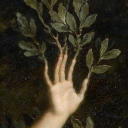
found this in my imgur fav’s, still think it occurs often, shared it..
162 notes
·
View notes
Text
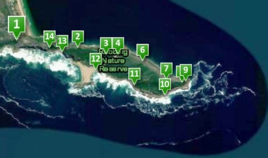
The beautiful Robberg Peninsula in South Africa. Learn how to make this webmap here
youtube
youtube
1 note
·
View note
Text
The beautiful Robberg Peninsula in South Africa. Learn how to make this webmap here
youtube
youtube
1 note
·
View note
Link
Here’s how to make a #webmap with #QGIS
1 note
·
View note
Video
youtube
Here’s a #GIS tutorial on how to use basic #editing in #QGIS.
3 notes
·
View notes