
» Limbs Disarm: Instagram and Etsy shop. » My Photos: megaliths, nature, ancient places, neolithic, iron and bronze age, viking age artifacts, punk, metal and motorbikes. » Feral Thrust: my band.
Don't wanna be here? Send us removal request.
Statistics
We looked inside some of the posts by dun-scathach and here's what we found interesting.
Average Info
Notes Per Post
37K
Likes Per Post
19K
Reblog Per Post
18K
Reply Per Post
15
Time Between Posts
4 months
Number of Posts By Type
Photo
13
Text
3
Video
1
Last Seen Tumblr Blogs


Fun Fact
Tumblr has 411 employees.
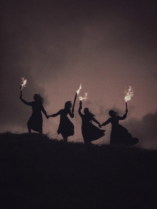
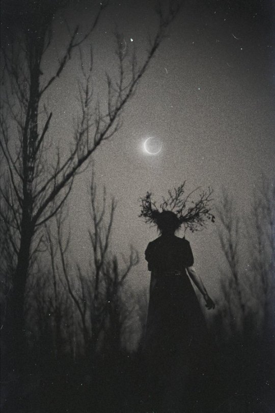

Photo
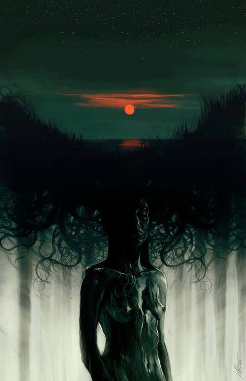
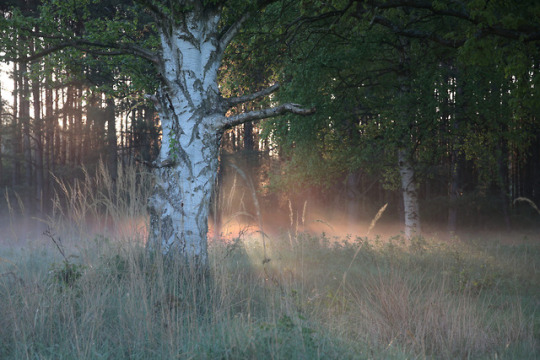
“There is no coming to consciousness without pain. People will do anything, no matter how absurd, to avoid facing their own soul. One does not become enlightened by imagining figures of light, but by making the darkness conscious.” ~ Carl Jung Artist: Jeff Simpson
589 notes
·
View notes


Text
I am wild waves dancing deep-sea determination
the clarity of raindrops and the complexity of a storm
I fill you to the brim with blood, sweat and tears I hold you, envelop you, through rough and through calm
I am life seeping through roots and sap rising in leaf
I am quench of thirst and emotion buried deep
I am sea-salt and sand-full stretched across the earth
I am tears for the end I am safe arms at birth
I am, always. Water.
5 notes
·
View notes
Video
instagram
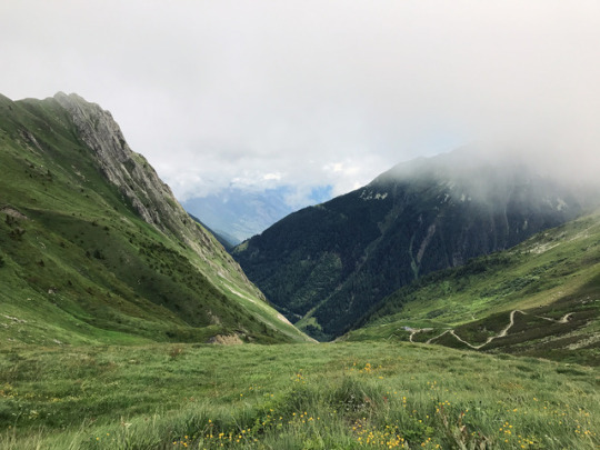
We're back. We drove 9000 km/5600 miles crossing central Europe and exploring Norway from one end to the other. We started from Kaupang in the South, visited the burial area of Istrehågan, stopped by the huge burial mounds of Oseberg and Gokstad, the tumuli in Borre and the huge Viking Hall reconstruction at the Midgard Vikinsenter. We went to Heddal stave church and to Oslo and its museums, where we could see some of the best preserved Viking ships and the incredible findings of the Oseberg burial. We walked through the Norsk folkemuseum, where you can enter different original buildings from different ages and visit the stave church that used to be in Gol. On our way to Sognefjord we stopped at Borgund and at the reconstructed Viking village of Gudvangen, which has one of the most breathtaking settings of any reconstruction I've ever seen. We crossed the mountains and reached Hopperstad, then the other side of the fjord and drove all the way to Urnes, finding huge megaliths and neolithic tombs along the road. Then it was Jotunheimen nasjonalpark, with the highest peaks of the country, the glaciers and the snow melting so quickly for the strangely warm weather. It truly was incredible. We stopped in Trondheim to visit its archaeological museum and Nidaros cathedral, the burial place of King Olav, and we went to Stiklestad, where he died, and its cultural history museum. Then we slowly reached the North, crossing the artic circle and having some fantastic hikes along the way, watching the vegetation change from pine, spruce, ash and oak, to small mountain birch and finally tundra. We went to Lofoten islands, from the very South to the islands North of them, we went swimming every day as it was incredibly hot, hiked every night as the sun was still up but the temperature dropped, sometimes overflown by sea eagles crossing our path. In Vestvågøy we spent a day at the Lofotr Viking Museum, the massive reconstructed longhouse and village, which we dreamt about for years. And then we slowly went back South, stopping by some national parks, seeing more reindeer, elk, foxes and endless woods. There would be so much more to say but, unfortunately, no more character left. (at Hinnøya)
12 notes
·
View notes
Photo
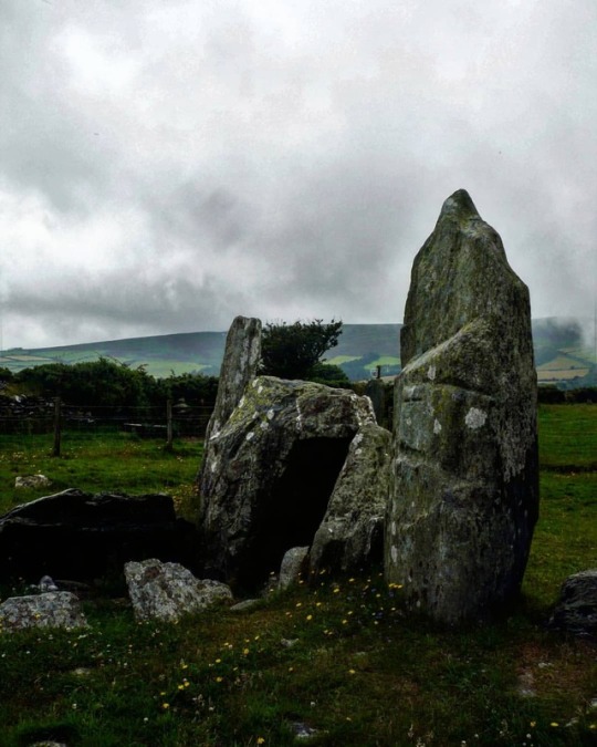
The megalithic portal of Cashtal-yn-Ard, Maughold parish, Isle of Man. The ancient burial chamber known as ‘Cashtal-yn-Ard’ stands on the edge of a hill to the northeast of Glen Mona, just to the south of Cornaa in the parish of Maughold, and close to the eastern coastline of the Isle of Man. It is quite a large megalithic structure at 130 feet in length. The name "Cashtal-yn-Ard" is thought to mean "The Castle of the Heights". Situated on raised land near the coast, the site provides impressive views overlooking most of the parish of Maughold and across the sea to the Lake District. Cashtal-yn-Ard is a large, oblong shaped chambered cairn, of ‘Clyde-Carlingford’ type, dating from the late Neolithic Age – roughly between 1,800-2,000 BC. It covers a large area of 40m (131 ft) long and 14m (46 ft) wide, and it still has its outer kerb stones, horned forecourt, entrance and 5 burial chambers. It is roughly aligned west to east. A semi-circular forecourt of six stones at the western end gives access, through a portal of two large standing stones, to a burial chamber of five compartments, originally slab-roofed. The slabs of these burial chambers are angled inwards and some have jagged edges, but sadly all but one of the roof-slabs have been lost, although this long flat-slab might not be the original one. Here unburnt bones, pottery and flints were found. With its five chambers it's quite similar in structure to the largely intact Brlas Knap long barrow in Gloucestershire. East of the the burial chambers is a mound of earth and stones reddened and fused by heat, which archaeologists can't explain. The whole monument, apart from the forecourt, was originally covered by a massive oblong cairn 130 feet long. Some of the large standing stones at the entrance have been re-erected or replaced. However, its large earth or stone mound, has gone – the stones now lost to local walls and farm buildings. The monument is very well-preserved and is said to be one of the largest of its kind in the British Isles. (presso Maughold)
#cashtal yn ard#isle of man#iom#maughold#glen mona#megalithic tomb#megaithic portal#chambered cairn#burial chamber#burial mound#long barrow#megalithic site#megaliths#megaithic#neolithic#neolithic tomb#neolithic monument#megalithic monument#pagan#standing stones#menhir#own
97 notes
·
View notes
Photo
Dun Bharpa chambered cairn (3500 BC), Isle of Barra, Western Isles. The cairn is quite impressive, 30 metres across and 5 metres high. The edge cairn is marked by large kerb stones and the entrance lies on the east side. A very large slab lies flat on the top, probably a capstone of the chamber. This is one of the best preserved chambered cairn in the Western Isles and my favourite place on the whole island. (presso Isle of Barra)
140 notes
·
View notes
Photo
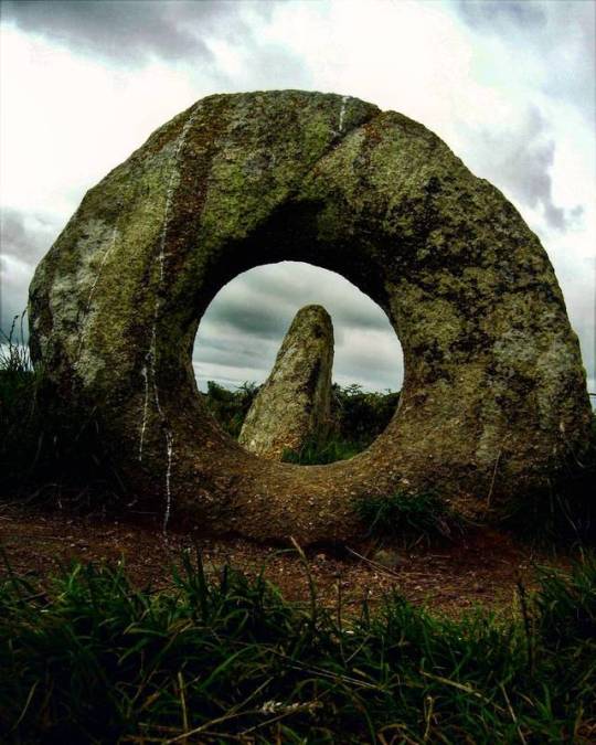
Mên-an-Tol, Madron, Cornwall. The monument consists of four stones: one fallen, two uprights, and between these a circular one, 1.3m, pierced by a hole about half its size in diameter. An old plan of Mên-an-Tol ('stone with a hole' in Cornish) shows that originally the three main stones stood in a triangle, which makes archaeo-astronomical claims for it difficult to support. They could be the remains of a Neolithic 'tomb', because holed stones are known to have have served as entrances to chambers. Its age in uncertain but it is usually assigned to the Bronze Age, between 3000-4000 years ago. Antiquarian representations of the site differ in significant details and it is possible that the elements of the site have been rearranged on several occasions. W Borlase described the monument in the 18th Century as having a triangular layout, and it has been suggested that the holed stone was moved from its earlier position to stand in a direct alignment between the two standing stones. In the mid 19th Century, a local antiquarian proposed that the site was in fact the remains of a stone circle. This idea was given additional support when a recent site survey identified a number of recumbent stones lying just beneath the modern turf which were arranged along the circumference of a circle 18 metres in diameter. The recumbent stones are somewhat irregularly spaced but the three extant upright stones have smooth inward facing surfaces and are of a similar height to other stone circles in Penwith. If this is indeed the origin of the site, the holed stone would probably have been aligned along the circumference of the circle and would have had a special ritual significance possibly by providing a lens through which to view other sites or features in the landscape, or as a window onto other worlds. There have also been suggestions that it may have been a component of a burial chamber or cist. There are instances of burial chambers close to stone circles, as at nearby Boskednan, and a barrow mound with stone cist has been identified to the north-east of the site, so it seems likely that the site was part of a more extensive ritual or ceremonial complex. (presso Mên-an-Tol)
57 notes
·
View notes
Photo
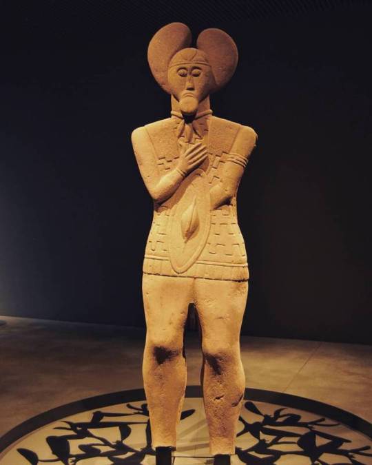
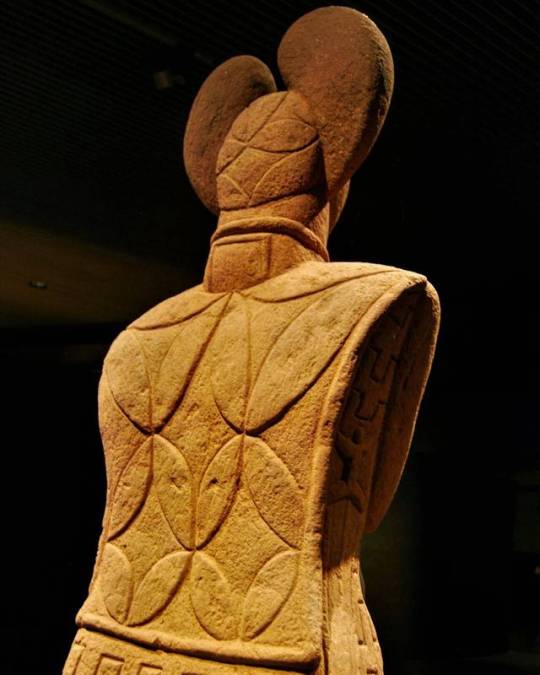
Last week at the Keltenwelt Museum, Glauberg, Germany.
The discovery in 1996 of the detailed, life-sized sandstone statue in Glauberg, a hillfort inhabited since Neolithic times, was a scientific sensation. Never before had such a perfect statue or stele of a Celtic warrior been uncovered. This extremely rare find, dating from the 5th century BC, was found in the ditch surrounding a huge barrow, which was totally vanished at the time and only detectable by a suspicious semicircle on an air photo in 1988, that led the archaeologists to investigate and discover this entirely unexpected burial site.
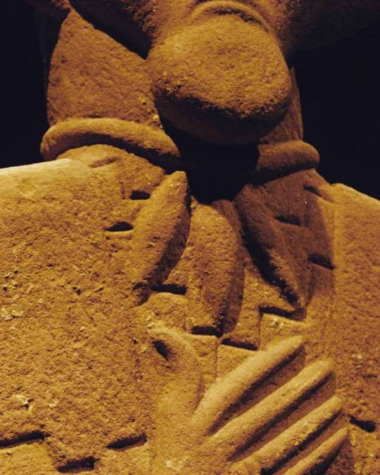
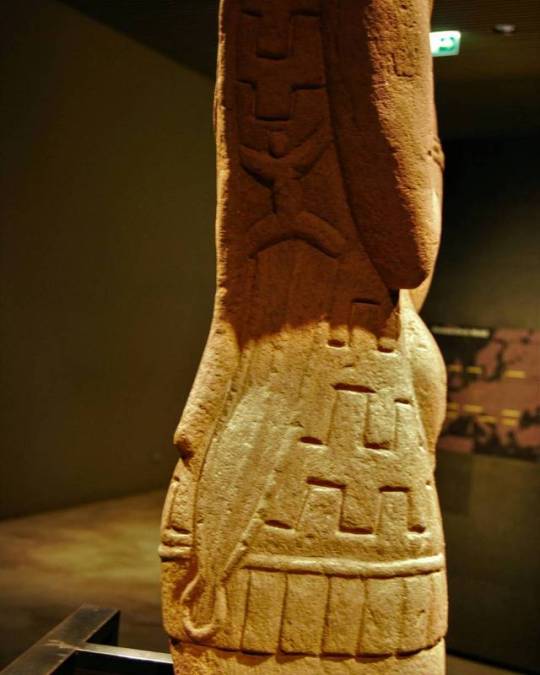
The stele, fully preserved except for its feet, depicts an armed male warrior. It measures 186 cm in height and weighs 230 kg. It is made from a type of sandstone available within a few kilometres of Glauberg. Unlike the Hirschlanden statue (found in 1969), who is naked, this warrior is fully clothed. Much detail is clearly visible: his trousers, composite armour tunic, wooden shield and a typical La Tène sword hanging from his right side. The moustachioed man wears a torc with three pendants, remarkably similar to the one from the chamber in mound 1, several rings on both arms and one on the right hand. On his head, he wears a hood-like headdress crowned by two protrusions, resembling the shape of a mistletoe leaf. Such headdresses are also known from a handful of contemporary sculptures. As mistletoe is believed to have held a magical or religious significance to the Celts, it could indicate that the warrior depicted also played the role of a druid. Fragments of three similar statues were also discovered in the area. It is suggested that all four statues once stood in the rectangular enclosure. Perhaps they were associated with an ancestor cult.
Parallels to the Glauberg warrior statue exist in the form of stelai from other La Tène sites, such as the Holzgerlingen figure (Württemberg State Museum in Stuttgart), a pillar-stele from Pfalzfeld (St Goar), today in the Rheinisches Landesmuseum Bonn, the Warrior of Hirschlanden and others.
The high quality of the tomb furnishings as well as other features associated with them indicate that the graves, and their occupants, were of extremely high status. They are therefore classed as “princely” burials, on a par with other well-known finds, including those at Vix (Burgundy, France), and Hochdorf (Baden-Württemberg, Germany).
240 notes
·
View notes
Photo
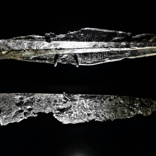
Photo I took of the Alemanni spearhead and blade with pseudo-runes engravings, found respectively in Tübingen and Tuttlingen districts. Landesmuseum Württemberg, Stuttgart, Germany.
Both weapons are exceptionally decorated on both sides with pseudo-runes and zoomorphic motifs.
Starting in the first half of the 6th century, the Alemanni adopted an indipendent culture of writing imported from Scandinavia, which died out in the early 7th century after about two generations. In contrast to Scandinavia, where several thousands inscriptions have been found and where runes remained in use until the 18th century in some cases, the Alemanni did not carve texts and words into stone, but engraved them on object such as jewellery, belts and weapons.
It’s interesting to note that about two-third of all runic engravings found in central Europe have been found on women’s clothing, accessories, jewellery and everyday objects. Women apparently not only preferred wearing objects decorated with runes, they were also rune-literate engravers themselves.
24 notes
·
View notes
Photo
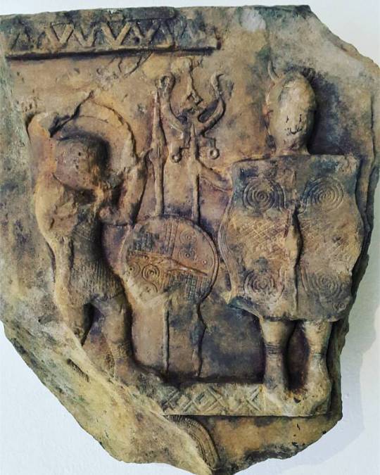
One of my favourite artifacts hosted temporarily at the Keltenmuseum in Hallein, Austria. Bas-relief depicting two human figures on the fragment of a stele or altar from Bormio (Lombardy), Italy, found in 1944 in the dry stone wall of a church (early 4th century BCE). The curved figure on the left could be a performer blowing a horn and wearing a dagger on its belt, or a warrior; in the centre there's a long spear, holding a round shield (possibly a votive offer to the god), and a trident-shaped militar insignia piercing a fish or more plausibly a bird, maybe a corvid, perching on it, held by the figure on the right, identified with the god Nethuns or Volcanus by some authors; this human figure, possibly a statue (due to its bare feet and position) is the most prominent and almost entirely hidden by a large hexagonal shield with spirals and linear decorations, it wears a horned Negau helmet. This scene could be linked to the worship of the healing waters of Bormio, and the Rhaetian or Etruscan people. While horned helmets among the Celtic tribes are well documented in artwork and coins from the period, actual archaeological confirmation of the existence of this particular type of helmet has been rare. . “On their heads they put bronze helmets which have large embossed figures standing out from them and give an appearance of great size to those who wear them; for in some cases horns are attached to the helmet so as to form a single piece, in other cases images of the fore-parts of birds or four footed animals”. Diodorus Siculus (on Celtic helmets) (History V.30.2)
23 notes
·
View notes
Photo
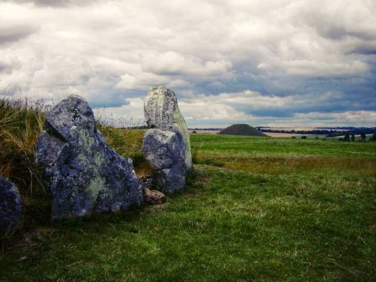
West Kennet Long Barrow and Silbury Hill in the distance, Avebury, Wiltshire. Perched high on a ridge looking down on Silbury Hill and the ancient cluster of monuments at Avebury is the Neolithic long barrow of West Kennet, one of the largest and most impressive barrow tombs in England. The barrow was built about 3650 BC, and used for only a short period of time as a burial site. Like most similar barrows, West Kennet was a communal site, not a memorial to a single important person. The remains of 46-50 people have been found in chambers built into the mound, which was in use for about 1000 years before the chambers were sealed and the barrow closed. Grave goods were found with the skeletons, including bits of pottery, beads, a stone knife, and other stone tools. Most of these goods date to between 3000 and 2600 BC. Around 2000 BC the tomb was sealed, and the central passage was filled with rubble and earth. The forecourt was blocked with sarsen boulders and a false upright made from two large sarsen stones. Finally, three huge sarsen stones were set up to block the entrance area. The barrow was made of sarsen stones and chalk rubble. The main entrance is in the east, with a central passage leading 18 metres to 5 small burial chambers, 2 on each side and one at the end. The entrance is through a semi-circular forecourt with a front of upright sarsen stones on a north-south axis. There were originally ditches all around the barrow but most of these have been destroyed by ploughing. The barrow is covered in turf, but it would originally have been covered solely in white chalk, so it would have stood out like a beacon on the top of the hill, and been visible for quite some distance away. It almost certainly formed a part of a vast ceremonial landscape in Avebury area. There is a small holy well at the base of the hill, called Swallowhead Springs, which is one of the sources of the River Kennet. (presso Avebury, Wiltshire)
28 notes
·
View notes
Photo
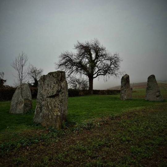
Corcelles-près-Concise, located between Lake Neuchâtel and Mont Aubert (Switzerland), not far from la Tène. The megaliths of Corcelles–Concise consists in four menhirs with a height of 1.50 to 2.50 metres, arranged in a trapezoidal configuration. Only three of them are authentic, the fourth had been erected in 1843 to replace a standing stone disappeared in the late Eighteenth century. The Eastern menhir has about 12 cupmarks with a diametre of 3 to 9 cm. In 1994, excavations revealed the existence of two other menhirs buried in a pit filled with pebbles, in the extension of the South and East menhirs. According to some studies, one of the axis between the stones seems to be aligned with the sunrise at winter solstice, another axis with the sunset of the same day. A third axis seems to be aligned with the sunrise at summer solstice. Moreover the site of Corcelles-Concise seems to be aligned to the moonrises as well, making it an ancient astronomical observatory, indicating major astronomical events.
31 notes
·
View notes