#cashtal yn ard
Photo
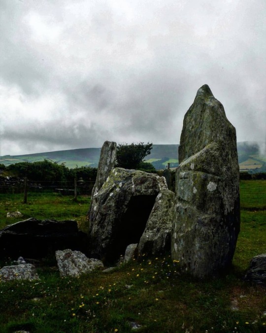
The megalithic portal of Cashtal-yn-Ard, Maughold parish, Isle of Man. The ancient burial chamber known as ‘Cashtal-yn-Ard’ stands on the edge of a hill to the northeast of Glen Mona, just to the south of Cornaa in the parish of Maughold, and close to the eastern coastline of the Isle of Man. It is quite a large megalithic structure at 130 feet in length. The name "Cashtal-yn-Ard" is thought to mean "The Castle of the Heights". Situated on raised land near the coast, the site provides impressive views overlooking most of the parish of Maughold and across the sea to the Lake District. Cashtal-yn-Ard is a large, oblong shaped chambered cairn, of ‘Clyde-Carlingford’ type, dating from the late Neolithic Age – roughly between 1,800-2,000 BC. It covers a large area of 40m (131 ft) long and 14m (46 ft) wide, and it still has its outer kerb stones, horned forecourt, entrance and 5 burial chambers. It is roughly aligned west to east. A semi-circular forecourt of six stones at the western end gives access, through a portal of two large standing stones, to a burial chamber of five compartments, originally slab-roofed. The slabs of these burial chambers are angled inwards and some have jagged edges, but sadly all but one of the roof-slabs have been lost, although this long flat-slab might not be the original one. Here unburnt bones, pottery and flints were found. With its five chambers it's quite similar in structure to the largely intact Brlas Knap long barrow in Gloucestershire. East of the the burial chambers is a mound of earth and stones reddened and fused by heat, which archaeologists can't explain. The whole monument, apart from the forecourt, was originally covered by a massive oblong cairn 130 feet long. Some of the large standing stones at the entrance have been re-erected or replaced. However, its large earth or stone mound, has gone – the stones now lost to local walls and farm buildings. The monument is very well-preserved and is said to be one of the largest of its kind in the British Isles. (presso Maughold)
#cashtal yn ard#isle of man#iom#maughold#glen mona#megalithic tomb#megaithic portal#chambered cairn#burial chamber#burial mound#long barrow#megalithic site#megaliths#megaithic#neolithic#neolithic tomb#neolithic monument#megalithic monument#pagan#standing stones#menhir#own
97 notes
·
View notes
Photo


Isle of Man 13/07/18
#went of a tour of a few neolithic chambered tombs#which was a nice way to spend a day off from archaeology#looking at more archaeology#we only got lost and went the wrong way a few times#king orry's grave#not that it was actually his grave#considering he's a semi-mythical king from the early medieval period#and this was early neolithic#cashtal yn ard#isle of man#photography
9 notes
·
View notes
Photo
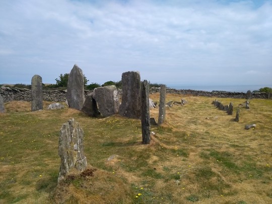
A prehistoric burial place at Cashtal yn Ard
8 notes
·
View notes
Photo

Seen better days ... abandoned farm machinery
near Cashtal yn Ard, the Isle of Man
more like this at: point-click-edit.tumblr.com
74 notes
·
View notes
Text
Museums, Monuments and Moomins - Day 2
We awoke after a night of being constantly rocked in a gentle yet maniacal way. First stop, coffee and cereal then we drove into the isles capital, Douglas.
We commenced with an omlettes and toast breakfast of the caliber you would expect from an establishment with the name 'The Caff'.

Then it was to the Manx museum which was suitably varied and well thought out
Wet paid a flying visit to the cloven stones, located on someone's front garden. Then into Laxey to climb the wheel and walk into the mine.
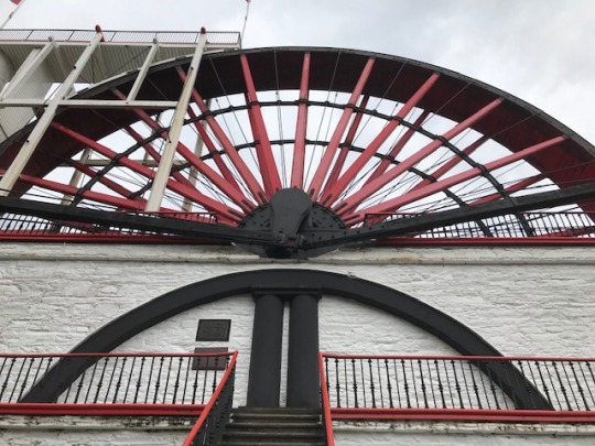
The Laxey wheel is a feat of engineering and oddly and rather cleverly, the man who designed it, deliberately concealed it's workings so you cannot see where the water comes out at the top.
Next stop, King Orrys grave. This neolithic site had been cut in two by a road and had a house built on it.
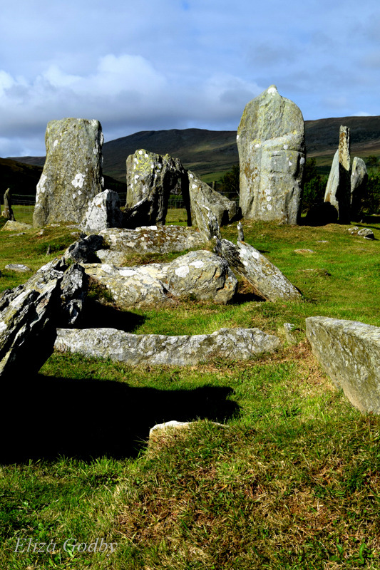
The next site, Cashtal yn Ard was the best site I have visited so far in a lovely rural location.
We found this lovely natural sculpture nearby :
I am finding the ancient sites here are a little different to the mainland ones. All of them so far, are in need of more signage!
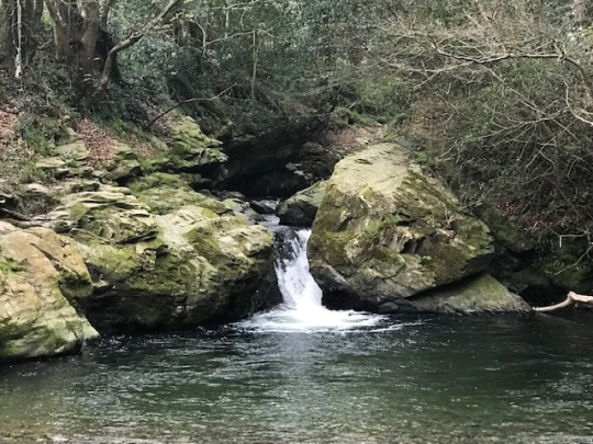
Our wild camping site for the night is Cornaa beach. We were a little more sheltered here. We all went for a little walk to some ruins and a beautiful little glade with mini waterfall, inviting pool and stepping stones !
That night, after childrens had got wet, changed and wet again. Kit started with a hacking cough. A Halls Soother, a Tyroset and an hour long story of Moomins followed by the Pied Piper, the latter successfully lured one child to sleep amidst the wind whistling and oceanic sounds of Cornaa Beach...
0 notes
Text
Visit the Isle of Man - The Gem of the Irish Sea
The Isle of Man, or also known as just Mann (with two “n”-s), is located between the islands of Ireland and Great Britain, on the Irish Sea with plenty of flight and ferry services from both. It is also called Ellan Vannin in Manx, the island’s native language. Though, not part of the UK, it has a special relationship with it. Like the Channel Islands, the Isle of Man is a Crown Dependency which means, that it is technically in the possession of the British Crown, not the UK. Today, the Queen still has the title of Lord of Mann (even though she’s a woman, she’s still known as “Lord”). They also use the British Pound as well as their own currency, which is not a legal tender outside the island, though. They’re not member of the EU.
The island has been inhabited since at least 6,500BC. Gaelic cultural influence started in the 5th century and then the Manx language was born, a branch of Gaelic, similar to some types of Irish Gaelic. The last native speaker of Manx, Ned Maddrell, died in 1974. There are continuous efforts to revive the language in terms of increased signage, radio broadcasts and bilingual primary schools. Although only a very small minority of the population is fluent in Manx, there is a larger minority with some knowledge of it at least.
The symbol of the island is the triskelion, known as the “Three Legs of Mann” or “Tree Cassyn Vannin” in Manx, which is an ancient symbol. The island also boasts with the oldest continuous parliament in the world, Tynwald Court, established by the Vikings in 979, which has been operating with no break since.
Mann also has its fair share of strange animals, such as its tailless cat or the Manx Loaghtan sheep, known to sometimes have four to six horns.
The island is also known as the motorcycle capital of the world because of the International Isle of Man TT (Tourist Trophy) Race that has been conducted here since 1907. The Isle of Man TT is considered the most prestigious motorcycle race in the world attracting tens of thousands of visitors ever year.
Apart from the race, the island is characterised by its beautiful scenery of lush valleys, barren hilltops and rugged coastline making it one of the most beautiful places in Britain to enjoy nature. Home to 17 natural canyons, many of which leads out to the sea and with more than 40% of the land unpopulated, as well as a number of excellent parks and gardens, the island is the perfect spot for a journey out to the countryside and to enjoy some peace and quiet. Of course, if you’d like to have your piece of silence, avoid the racing festival. The island is also a UNESCO-designated Biosphere Reserve.
Sights & Activities
North Mann
Situated on the very north of the island, the Ayres is a stretch of low-lying sand dunes along the coastline, great for birdwatching as well as walking on its marked natural trail. The area is also a National Nature Reserve with a Visitor Centre within the sand dunes and the Point of Ayre Lighthouse at the northernmost tip of the island.
On the north-east coast, you can find Cashtal yn Ard (Castle of Heights), a well-preserved megalithic chambered tomb dating back to around 2,000BC.
Douglas & Around
The island’s capital as well as largest town and most important financial centre is Douglas, situated on the east coast, with a wealth of hotels and restaurants. Across the water from Douglas, you can find the Victorian resort town of Blackpool, a huge favourite with holidaymakers.
The Great Union Camera Obscura, located at Douglas Head, was built in 1892 solely for the purpose of entertaining tourists. The camera obscura is a darkened room or building, which, via the use of lights, mirrors and lenses, reflects images of the surrounding area onto a large screen.
Just off the coast from Douglas, there is the Tower of Refuge, otherwise known as St Mary’s Isle, a small structure erected on a partially submerged reef, both for the purpose of providing warning and refuge for shipwreck victims.
Just 14km (8.7miles) north of Douglas, you can find Snaefell, the highest mountain on the island at 621m (2,034ft). To reach it, you can either follow the TT circuit inland up and over the mountain, or take the coastal route going through Laxey, which is home to the world’s largest working waterwheel. From here, you can take the electric tram travelling near the top from where it’s an easy walk to reach the summit.
Castletown & Around
On the southern coast, you can find Castletown, a quiet harbour town and the ancient capital of Mann. Here, you can find Tynwald Court and some of the most beautiful castles on the island.
The town’s most prominent sight is the impressive, 13th-century Castle Rushen, one of Europe’s best preserved medieval castles. Originally built for a Norse king, the castle has been a royal residence, a prison and a mint. Here, you can explore the gatehouse, furnished chambers, medieval kitchens, a dungeon and the flag tower, the latter one offering great views over the town and Mann’s southern coast.
The Old House of Keys is the former home of Tynwald’s lower house, beautifully restored to its 1866 state. Twice a day, visitors can sit in and take part in theatrical debates on the hot topics of the day. You can also learn a lot about Mann’s history here.
Balladoole, one of Mann’s most impressive ancient monuments, is situated just 2.5km (1.5 miles) west of Castletown and includes – a Bronze Age grave dating from 10,000BC – a Christian chapel and graves from around 900AD – and the remains of a Viking ship.
The small island of Calf of Man, situated just off Cregneash at the south-west tip of Mann, is one of Britain’s major bird migration routes and has been an official bird sanctuary since 1939. Bird-watching tours to the island, as well as various coastal cruises and fishing trips are available from Port St Mary, situated just a 9-minute drive west of Castletown.
The Sound Visitor Centre in Port St Mary is one of the most picture-perfect spots on the southern coast of the island offering plenty of information about the history of the area and a wealth of coastal footpaths and various outdoor activities ranging from walking, hiking and cycling to kayaking and diving.
On the southernmost tip of the island, sitting on an upland plateau, you can find the Cregneash Village Folk Museum. The village was one of the last strongholds of the Manx language and here you can learn more about traditional rural life on the island and experience life first hand in a typical 19th-century Manx crofting community.
A further 2km west of Port St Mary, you can find the beautiful Victorian seaside resort of Port Erin, home to a small Railway Museum. The two ports are linked by steam train as well. There is also a great nature trail from Port Erin to Bradda Glen and Milner’s Tower offering breath-taking panoramic views over Calf of Man.
Check with Scarlett Visitor Centre in Castletown for the magnificent natural surroundings of the area boasting with breath-taking coastal scenery and fascinating rock formations. They also provide maps and data on nature trails and walks in the area. There’s also a short film featuring the region’s rich coastal flora and bird life.
Peel & Around
Situated on the west coast, Peel is the island’s most picturesque coastal town with a glorious sandy beach. Here, you can find the Manannan Museum, introducing you to the island’s rich Celtic and Viking history and heritage.
Just across Peel, on St Patrick’s Island (connected to Peel by a causeway), you can find Peel Castle, an impressive fortification castle built by the Vikings in the 11th century as a military stronghold and royal residence. After the rule of the Vikings, the castle continued to be used by the Church, who built a cathedral there. It was eventually abandoned in the 18th century. Today, the buildings within the castle are mostly ruined but the outer walls remain intact. Informative audio guides are available.
Just a 15-minute drive south of Peel, you can find the magnificent, secluded Niarbyl Bay characterised by its rolling hills, thatched cottages and winding coastal paths leading to its gorgeous white beach.
Near Peel, you can find Tynwald Hill, a four-tiered hill, one of the island’s most distinctive landmarks and a symbol of the Isle of Man’s independence as a self-governing Crown Dependency. Tynwald Hill is also home to an open-air meeting of the island’s parliament, Tynwald, once a year. The hill is thought to have been built in the 13th century from piles of soil and stones brought from all over the island.
Visit the Isle of Man – The Gem of the Irish Sea was originally published on Freeminimaps - discover authentic experiences!
#Ayres#Balladoole#Bradda Glen#Calf of Man#Cashtal yn Ard#Castle Rushen#Castletown#Cregneash Village#Douglas#Ellan Vannin#Manannan Museum#Mann#Milner's Tower#Niarbyl Bay#Old House of Keys#Peel#Port Erin#Port St Mary#Snaefell#Three Legs of Mann#Tynwald Hill#Visit the Isle of Man
0 notes
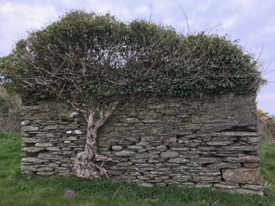
Photo


Isle of Man 13/07/18
#what a lovely tree house#i love abandoned buildings#steadily consumed by the growth of nature#in the middle of a field on the way up to a tomb#cashtal yn ard#something poetic about that in there somewhere#isle of man#photography
4 notes
·
View notes
Photo
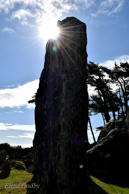
Sunlight behind an ancient standing stone at Cashtal yn Ard
#sunlight#graves#prehistoric#standing stones#cashtal yn ard#isle of man#photography#my photography#my edit
0 notes
Last Seen Blogs

daryldixon83
twd,frank castle, anything goes 😘

tawhyung
berew

basic-bi-nch
basic binch

vikcrobio
Sin título

lanadeldying-blog
stasya ౨ৎ