
Last Seen Blogs

kellywar-jijiloryo
Kelly war

spcewild
spcewild

moonlight-s0onata
The moon looks pretty tonight

henrietta-blues
“No one wanted to be the last man left awake.”

Text
SNK Fandom Events: A Directory
A list of all the fan-organized ship and character weeks in the Shingeki no Kyojin/Attack on Titan fandom in 2018. If you find that there’s event details containing outdated/inaccurate information, please let me know!
(Special shoutout to Heidi @erensjaegerbombs for letting me know the info for many of these SNK events!)
FEBRUARY (passed)
4 Feb - 11 Feb: Rivetra Week organized by @rivetra-week
14 Feb - 15 Feb: Rivamika Valentine organized by @rivamikaevents
14 Feb - 14 Mar: Ereri Month of Love organized by @ererievents
16 Feb - 18 Feb: Eruri Valentine Weekend organized by @eruriweek
MARCH (passed)
4 Mar: Beruani Day (1)? organized by @beruanism
16 Mar - 22 Mar: Annie Week organized by @annieweek
25 Mar - 1 Apr: Petruo Week organized by @petruoweek
29 Mar - 31 Mar: Eren Events organized by @eren-events
APRIL (current)
3 Apr: Beruani Day (2)? organized by @beruanism
7 Apr - 14 Apr: Jearmin Week organized by @thejearmincollective
13 Apr - 19 Apr: Ereani Week 2018 organized by @ereannie
14 Apr - 15 Apr: A Weekend with the Ackermans organized by @rivamikaevents
20 Apr: Levihan Week Easter Egg Exchange organized by @levihanweek
22 Apr - 29 Apr: Bottom Erwin Week organized by @bottomerwinweek
MAY (upcoming)
12 May - 13 May: Jeankasa Canon Weekend organized by @jeankasa-events
25 May - 27 May: Ereri Fluff Weekend organized by @ererievents
JUNE
TBA: Reibert Week organized by @reibertweek
24 Jun - 30 Jun: Armin Week organized by @arminarlerttribute
JULY
TBA: Shingeki Week Part 1 organized by @fyshingeki
AUGUST
3 Aug - 5 Aug: Ereri Angst Weekend organized by @ererievents
30 Aug - 5 Sep: Hange Week organized by @hangeweek
SEPTEMBER
23 Sep - 29 Sep: Ereri Canonverse Week organized by @ererievents
OCTOBER
[none that i know of]
NOVEMBER
[none that i know of]
DECEMBER
TBA: Veterans Secret Santa organized by @alemanriq
TBA: Levihan Secret Santa organized by @levihanweek
21 Dec - 25 Dec: Ereri 5 Days of Kinkmas organized by @ererievents
Events run in the past that I’m not sure will be continued this year:
17 Jan - 24 Jan: Mikenana Week 2016 organized by @mikenanaba
10 Feb - 16 Feb: Mikasa Week 2017 organized by @mikasatribute
11 Jun - 18 Jun: Yumihisu Week 2017 organized by @yumihisuweek
24 Jun - 30 Jun: Armin Tribute Week 2016 organized by @arminarlerttribute [continued this year]
10 Jul - 16 Jul: No Hate Awareness Week 2.0 organized by @snkartists [likely to continue this year]
16 Jul - 22 Jul: AOT Week organized by @aotweek
31 Jul - 6 Aug: SNK Crack Theories Week organized by @snkcracktheoriesweek
31 Jul - 6 Aug: Eruri Week organized by @eruriweek
Aug: Erumika Week organized by [???]
2 Aug - 6 Sep: Eruhan Month 2015 organized by @the-eruhan
6 Aug - 12 Aug: Mikannie Week 2017 organized by @mikannieweek
27 Sep - 3 Oct: Eren Week 2015 organized by @eren-week
1 Oct - 7 Oct: Eremika Week 2017 organized by @eremikaweeks
8 Oct - 14 Oct: Erwin Smith Week 2017 organized by @erwin-week
19 Oct - 26 Oct: Mikasasha Week 2015 organized by @mikasashaweek
1 Nov - 7 Nov: Mike Zacharias Week 2017 organized by @mike-zacharias-week
3 Nov - 10 Nov: Aruani Week 2015 organized by @aruani-week
Dec: Eremika Secret Santa Exchange 2016 organized by @eremikaweeks
Dec: Rivamika Sumtmas 2017 organized by @rivamikaevents
19 Dec - 25 Dec: Levi Week 2015 organized by @leviweek
23 Dec: Reibert Secret Santa Exchange 2017 organized by @reibertweek
162 notes
·
View notes
Photo

★ Kotikomori | Mustang and Hawkeye ☆
✔ republished w/permission
6K notes
·
View notes
Link
Chapters: 1/1
Fandom: Shingeki no Kyojin | Attack on Titan
Rating: General Audiences
Warnings: No Archive Warnings Apply
Relationships: Armin Arlert/Sasha Blouse
Characters: Armin Arlert, Sasha Blouse, Hannes (Shingeki no Kyojin)
Additional Tags: One Shot, Alternate Universe - Edwardian
Series: Part 7 of AruSasha Fics
Summary:
Time is brief but life can be spectacular.
5 notes
·
View notes
Text
Armin x Sasha/AruSasha Week [23-29 July]
Hey! I wanted to create an Attack on Titan Ship Week for my rare OTP!

Day 1: First or Lasts (First Impressions/Last Goodbyes, etc.)
Day 2: Couples Moments & Times (Dates, Movie Nights, etc.)
Day 3: Hurt & Comfort/Angst & Fluff (Canon Universe)
Day 4: Celebration (Birthday, Anniversary, Firsts, etc.)
Day 5: NSFW (Smut or whatever your filthy mind comes up with.)
Day 6: Past/Present/Future AU or an AU of Your Choice (Reincarnation, High School, Apocalypse, Fantasy, Royalty, Sci-Fi, Super Powers, Pirates, Soul Mates, Body Swap, Role Swap, Hero & Villain, etc.)
Day 7: Your Suggestions (Whatever you want or suggest. Be Civil.)
15 notes
·
View notes
Text
Worldbuilding: City Structure Models
[source: City-Building]
Every city provides an array of service, residential, and industrial functions. How these services are arranged in relationship to one another is what we call the urban structure, or the land use structure.
There are three modern models used to describe these structures, which were based on observations of the North American city, as well as some additional models that help explain unique situations and antiquity. However, it is important to note that not every city falls into one of these models. These models attempt to explain larger organizational trends of people/services seen in existing cities. They do not dictate ultimate city form. In other words, you couldn’t use these models to decide whether or not your street patterns are gridded or irregular, you couldn’t use it to decide whether or not your city is planned, circular, square, or organic in form. You could design a grid city that fits any of these models for example! City form is only influenced, not dictated, by your urban structure.
Thus we can conclude that an urban structure model is more theory on the spacial relationships goods, services, and people need and have to one another in a city, and city form is your physical implementation of these ideas.
I am going to explain each model and then point out the Take-Aways, or the critical content and concepts that will help you in deciding and designing your city. Consider it your TL:DR version.
So! before we delve into this, I want to explain what a city ‘core’ is, mostly because it gets referenced quite a bit when discussing the models. A city core is the area of the city where the flow of people, culture, goods, services, information, etc is most concentrated. Often times it is considered the center of business. Cost of living is the highest here, as is the magnitude of activity. Today we may refer to this as the ‘downtown‘ of a city, or the ‘hub‘ or the ‘heart‘. Examples in antiquity are the Agora in Athens or the Roman Forum, and Central London in the modern. Cities can have one core or several, depending on many different factors.
So now that we have an idea of what a core is, lets look at these models!
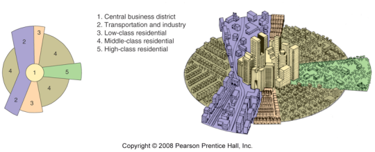
Concentric Zones

In this first model, the city is organized in a series of rings emitting concentrically outwards from the Core. As you can see above, that core of the city makes up the entire first ring, followed by (2) a ring of industry & factories, (3) a zone of transition intermixing working class housing & industry, (4) working–class residences, (4) middle–class residences, and (5) the commuter zone. When applied generally, you can see this either in play or in the past in many American and European cities.
In real-time practice, these zones would encroach somewhat on each other, and would need to respond to any cultural influences and demands made by the terrain. As with all models, it needs a reasonable transportation network (good roads, trains, etc). However, in a Concentric Zone Model, most often the transit system is expensive and use is thus limited to the wealthy.

The Core & Inner Rings of Chicago
This model was developed by sociologist Ernest Burgess in his observation of cities in the American pre-car, industrial age (specifically Chicago). This model was based on the (at that time) observation that the poor did not have access or money to bring themselves in and out of the city every day (because transit was expensive!), while the wealthier wanted fresh air & space.
Here is the concentric model overlay of Chicago, as Burgess observed in 1920:

If you are interested in seeing how Chicago developed over a span of 100 years, this site has some really great images and a quick overview! If you do take a look, notice how each year Chicago expands concentrically outwards, as does the rail road. This animated graphic goes through changing median incomes over the last 40 years, where you can still see present the observations Burgess made–a strong economic center, surrounded by poorer industry & working class residences, followed with the middle & upper classes always remaining even further outwards.
The First Take Away: This model really hits home the influence of a core, whether it is business, legislative, or religious. A core is a major organizational component of a city–knowing where your core (or cores) are in your city will help you decide your next major moves.
Though this model was developed in reflection of the early industrial city, where you had concentrated inner city poverty and outer wealthy suburbs, you can always adjust these relationships and ring definitions as you build your own city. And these relationships are different, depending on the city you look at. It is easy to make the case for a wealthy inner city that surrounds the core, with manufacturing and poverty towards the outer rings (See: New York, See: Ancient Aachen).

Aachen City Plan (Check out High Res here!!)
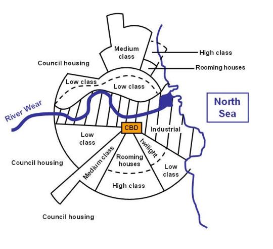
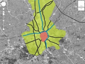
Districts/Sectors with a Central Hub
This model also has a single core, with social groups and industries arranged around it in a series of sectors or districts that are more defined by their relationship to major transit lines. In a way, this is just an evolution of the Concentric model–where, as a more complex and affordable transit network emerges, the city too responds.
The lesson here is that city form follows transit lines and that you need to think about who uses those lines: Industry? Low Income Residents? Commuters? Furthermore, Higher income neighborhoods tend to follow higher ground, extending along non-industry river fronts, along transit lines as well, and usually towards open country. This model also acknowledges that there is high-income residents interested in living close to the core.
An example would be Sunderland, England, as diagrammed below; read more here. The waterline here is a major transit line and you can see industry hugs this waterway. Lower classes in turn hug the industrial belt, where they would find a source for work. Middle and upper classes expand towards the open but still have relative access to the CBD (Central Business District/Core)
The Second & Third Take Away: This model is a little more realistic when it comes to more industrialized cities. People and industry pretty much always follow transit systems. That doesn’t mean you cant have several transit systems in place. Maybe there is one train line for industrial use and one for commuters? Maybe you have some major public boulevards for carriages used primarily by merchants and high-income and offshoot pedestrian paths for the low-income residents? Service roads and commercial streets?
This model also acknowledges that people of all income classes like to live closer where they work.
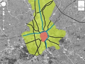
I am adding a map of Bruges, though it never really underwent any sort of industrialization. Here you can see how the city has expanded along major transit lines and water ways–the most along the major water channel, which happens to have a significant amount of industry surrounding it as you move north.
Districts/Sectors with Multiple Nuclei
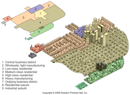
This model states that cities are composed of several cores-religious cores, industrial cores, business cores, cultural cores, etc. Around each of these cores conglomerate related services. For example, a university core may attract well-educated residents, pizzerias, and bookstores, whereas an airport may attract hotels, low-income residences, and warehouses. Incompatible activities will avoid clustering in the same area. (1)
This obvious acknowledges that different functions require different amenities. But, it also that a city requires a really strong transit infrastructure. This is most likely a system to exist on a large scale where cars or some other form of rapid transit are in place.
Los Angels is a great example of this, since the city is so large. One can even make an argument for NYC–with a cores around Wall Street, Times Square, Central Park, and Downtown Brooklyn–though modern NYC is a little more complicated when it comes to analyzing form due to all the planning & regulation that has influenced development over time.
The Fourth and Fifth Take Away: Larger cities tend to have several cores. Consider cores for religion, culture, ethnic backgrounds, businesses and trades, classes and government. Though there may be one central pulling force for all of them, they all most likely also have their own centers of operation. Additionally, different cores/functions require different amenities and have different users.

Garden City by Howard
Additional Models and Structures
So the previous three were all conceived upon the studying of North American cities. Thus you may find this doesn’t always apply in Europe, modern day 3rd worlds, and elsewhere. (If applied generally, these cities may fit). I want to briefly touch upon a few other patterns and models as well.
Irregular / Organic Pattern
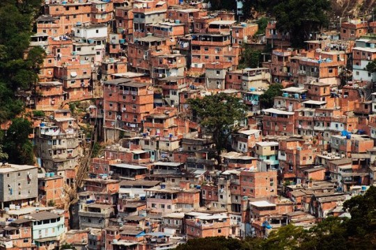
Favela, Rio De Janeiro, Brasil
Most likely you’d see this occurring now in third world countries, where there is no rhyme or reason as to what is getting built where and people are building for themselves. There is no clear plan for expansion–it just happens on its own when the population needs it to. City form can take all sorts of an appearance, industries can get mixed quite heavily (so there really is a complete free for all) but you still will most likely see a separation of high and low income.
Planned Models
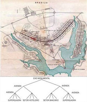
Brasillia, Brazil
I wanted to include planned cities because they appear all the time throughout history. A planned city is often the product of a planner taking an urban structure (existing or invented) and allowing it to dictate city form. These types of cities have been in use for thousands of years–with deliberate premeditation to zoning, land use, ritual, administration, and critical city systems.
We will delve heavily into these later on in separate articles as well. But the take away here is that, if you wish, you can take (or design) any urban structure / model and allow it to inform all your decisions about placement of housing, streets, infrastructure, and services. A city can be completely preconceived, and there are examples of planned cities going back thousands of years.
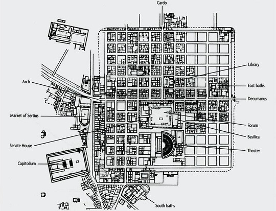
Timgad, Roman City 100AD
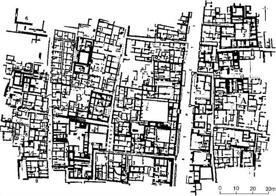
Mohenjo-Daro, 2600 BCE
Evolving / Patterns over Time

Europe and Middle Eastern cities each have a lot of history behind them, which of course often gives them no easily identifiable city structure today (though many can broadly fit into one of the models above). These cities have often evolved out of previously large towns or ports and have seen their borders continually expand.
Originally, many were built for the pedestrian (vs the more modern cities in North America for the cart, car, & commerce). Their form and centers are also defined strongly by their original hook—Islamic cities tend to be centralized around religious grounds, whereas many of the cities in England are centered around their ports and rivers. With time they expanded to include other services, and perhaps other cores, but this ‘old city’ still remains present and active.
The Take Away? All cities evolve over time. The longer the city has existed, the more likely there are multiple designers, cores, and ideologies of planning at play, the more likely you will have a mix of modern & ancient infrastructure and materials (dirt, cobble, and paved roads all within radius, for example, or the old city vs the new city). Additionally, older cities are more likely to be pedestrian friendly, with pedestrian-only streets, plazas, and public space.
You can see here in this map of Bruges, the old city in pink and the new city extents in green, growing along major transit paths.
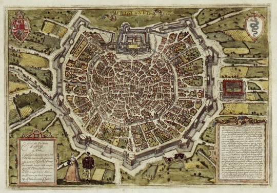
Milan, 1600s
And Beyondddd….

Erich Kettelhut – Metropolis
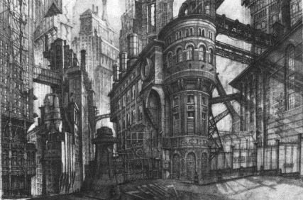
Gotham City Concept by Anton Furst and Nigel Phelps
I’m sure there are more theories of city structure out there–there are definitely numerous theoretical and unrealized designs for cities floating around in dusty tomes of history and the deep recesses of the net. I’ll eventually touch upon some of those, but as to general city structure, this should be a good place to jump off from. Realize that you can create your own city structure and logic to things. These models above are based on the observable reality here today on this earth.
Overall Take-Aways:
These structural models are simplified ways of looking at what are ultimately very complex systems. These are a good place to start if you are unsure where to begin, but don’t be afraid to have anomalies and to allow your city to grow organically as well. No city that exists today can perfectly fit any of these models, and neither really should yours. :) Mix, match, and make it work.
These models don’t completely dictate form. City form, street patterns, and architecture are all left to your personal discretion. You can design a gridded city for any of these models, for example.
Your city has a history, and you need to know it if you are going to design it. As above, how old is the city? Did it start as a city (preconceived) or was it originally a town? Was it a series of villages and towns joined together through expansion or conquest? Were there many designers, over many years, or just one? Or none?
Know your city profile. What is its major hook–religion? commerce/trade? legislative? This will help you identify city cores.
People and industry pretty much always follow transit systems.
In cities, the poor are more likely to live close to where they work when there is a poor/ineffective/non-existent/expensive transportation system in place. This is why in NYC, for example, middle and low income residents live in the outer boroughs, because transit is cheap and effective!
Having fresh air, space, good light are attractive to the wealthy. If you want them in your center, then maybe your center is garden-city styled, gated, or the likes.
The wealthy do not want to live near low income housing, usually due to its poor quality, and they do not want to live near industry.
Old cities are more pedestrian friendly, Modern cities more transit friendly.
All cities evolve over time and can shift between models in this evolution.
‘Mixed Income’ residential areas are naturally uncommon, but they do exist and are planned and executed often through law.
Knowing what your transit system is and where your critical arteries lie will help you design your city structure.
Different industries and services have different needs, both in terms of labor supply, service supply, and access to transit. We are going to discuss this in the next article!
Exercises & Questions
The following questions will help you figure your city form.
When was your city established?
What major topological features intersect your city?
Was your city conceived as a city or did it grow forth from a town? If it grew forth from a town, you probably will have an ‘old city’ district, or some sort of indicator of the old. You also will most likely, though not always, have your core somewhere located in that old city. Its infrastructure will also be a little more messy, and the city most likely will be more pedestrian friendly.
Has there been any urban renewal? – Specifically, major projects to protect or replenish different parts of the city. Cities subject to massive urban renewal projects often see a shift in where their populations live and do business.
How large is the city? — Area & population?
What age of technology was your city built in? — For example, cities built prior to cars tend to have small streets and pedestrian only ways (think tiny, winding streets like this one in Toldeo) whereas cities built for cars tend to be a little more spaced out, with every street being car accessible. You just wouldn’t get those tiny winders in cities designed or conceived in a post-industrial age.
What infrastructure is available today?–what age of technology are you in? Cart & Wagon? Trains? Cars? Space ships? These all need to be accounted for and your city form needs to change from when it was first built to today (or it doesn’t. see: Venice)
What is your city hook? Culture & Entertainment & Tourism? Trade & Banking? Administrative activity? Religion? This will help you figure out what your city cores are. You can have one or several or all of these being important, if you wish. But be careful, too complex can be messy. All of these of course will exist in your city on some level, but here you are looking to decide what the biggest driver(s) is. We will discuss this in depth later.
What major industries operate in your city? Do they need their own districts? Do they have any topographical needs? What services do they need to be adjacent to? For example, a butcher in a medieval city probably should be downstream from residences, so their pollute doesn’t affect drinking waters. A university will most likely be established near the city archives or library. Factories that employ cheap labor are also probably close to low-income housing. etcetcetc.
What is the social stratification in your world/city? Do the rich loathe the poor or take pity? How many classes or tiers are there in your society? Do they mingle or do they avoid one another? Are there orphanages? Slums? Places where each class does not, or can not, go?
What is the racial stratification in your world/city? In many cities, people of different ethnic and racial backgrounds tend to stick together, especially immigrant populations. Look at NYC–traditionally, the following neighborhoods popped up to serve migrant populations: Little Italy (Italian), Harlem (African American), Spanish Harlem (Mexican), Chinatown (Chinese), Five Points (Irish) etc. Your city probably has some version of this too.
Are there any major ceremonies that all portions of the population acknowledge? For example, say you have a city who whenever a new king is crowned, there is a big parade. Say the King gets crowned in the major church and then proceeds back through the city to his castle (all the way on the other side of the city). It would make sense, then, for there to be a major boulevard connecting this church to the castle. So figure out if you have any important ceremonies, religious or military celebrations, etc and decide if your city should respond accordingly.
Are there any major roads running near by or to the city? Most likely they should be intersecting your city, because most major cities are points of intersection–roads, trades, cultures, etc. These roads also will become your major boulevards, transit pathways, etc.
Bonus Reading and Sources:
Burgess E.W. (1924)”The growth of the city: an introduction to a research project” Publications of the American Sociological Society, 18:85-97
Hoyt H (1939): “The structure and growth of residential neighborhoods in American cities” Washington DC; Federal Housing Administration
Harris C D and Ullman E L (1945), “The nature of cities” Annals of the American Academy of Political and Social Science 242: 7-17
Rodwin, L. (1950) “The Theory of Residential Growth and Structure”, Apprasial Journal, 18, pp.295-317
Harris, Chauncy “The Nature of Cities” http://www.jstor.org/discover/10.2307/1026055?uid=8305256&uid=3739832&uid=69&uid=2&uid=3&uid=8305240&uid=62&uid=3739256&sid=21104557850137
Jean-Paul Rodrigue, Urban Land Use Models in Urban Land Use and Transportation
Hofstra Urban Land Use Burgess Model http://people.hofstra.edu/geotrans/eng/ch6en/conc6en/burgess.html
You can read more in depth about structure models that have emerged for British & European cities here.
15K notes
·
View notes
Text
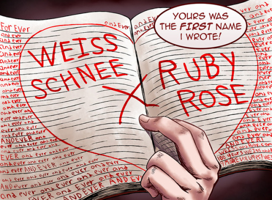
So Many Fics to Write, Yet So Little Time to Write Them
I have Too Many Ideas Syndrome [T.M.I.S.]. There have been many days where I’d sit down and write a lengthy fic, fleshing out the basic of the plot and then... nothing. I don’t know what it is but I’m sure its motivation and the drive to finish.
Here’s a list if you wanna know;
Attack on Titan
1: Mikasa/Armin, Krista/Eren, Sasha/Jean, Armin/Ymir
2: Armin/Annie, Krista/Ymir
15+: Mikasa/Sasha
10+: Armin/Sasha
RWBY
1: Qrow/Winter, Blake/Weiss
2: Blake/Ruby, Penny/Ruby
3: Ruby/Pyrrha
10+: Ruby/Weiss
My Hero Academia
1: Izuku/Ochako, Kyoka/Denki, Tsuyu/Izuku
5+: Shoto/Momo
And then there’s the rewrites...
0 notes
Photo


Star Wars AU anyone?
Check it on my gallery! https://www.pixiv.net/member_illust.php?mode=medium&illust_id=64070638
Please, do not repost.
177 notes
·
View notes
Text
A Ravishing Breakfast
This was done very fast and in one night once I found out 26th July is Sasha’s birthday!
So here it is a birthday fic for one of my favorite characters of Attack on Titan. It nearly went down the angst route but I changed it and hopefully it turned out better.
May you live long and feast upon the land potato girl!!!
3 notes
·
View notes
Photo

Yeah, so I’m finally doing this. Click it c:
441 notes
·
View notes
Photo


10K notes
·
View notes