
A look into my adventures… Let's explore!! Follow me! The Beginning...
Don't wanna be here? Send us removal request.
Statistics
We looked inside some of the posts by squeakylily and here's what we found interesting.
Average Info
Notes Per Post
15
Likes Per Post
15
Reblog Per Post
0
Reply Per Post
0
Time Between Posts
4 days
Number of Posts By Type
Text
8
Last Seen Tumblr Blogs


Fun Fact
Tumblr was attacked by a cross-site scripting worm deployed by the Internet troll group GNAA on Dec 3, 2012.
Text
The Huntington
The Huntington Library, Art Collections and Botanical Gardens (The Huntington) is a collections-based educational and research institution established by Henry E. Huntington and located in San Marino, CA. With an extensive art collection that focus in 18th- and 19th-century European art and 17th- to mid-20th-century American art, the property also includes approximately 120 acres of specialized botanical gardens.
The Huntington is one of the largest and most complete research libraries in the US in the fields of British and American history and literature. For the general public, the Library has on display some of the finest rare books and manuscript of Anglo-American civilization.

More than a dozen gardens cover 120 acres of the 207-acre grounds. A nature photographers dream come true!

Among the most remarkable are the Desert Garden, a large outdoor grouping of mature cacti and other succulents.

The Japanese Garden, featuring a moon bridge, a Japanese house and a ceremonial tea house.

Personally, I enjoyed the Lily Ponds, with a serene backdrop and enormous koi fish, a very lush and green area.

Best time of the year to visit is during Spring were all the flowers are blooming and sure promise to be a spectacle of color and beauty.
There are various choices for refreshments, with the Rose Garden Tea Room being the most popular, so reservations are required.
The Huntington is open year-round, with extended hours during the Summer. Closed on Tuesdays and major holidays. Admission is $20 (weekdays), $23 (weekends) for adults, and $8 for kids. Membership starts at $120, for more details and info, check their website, www.huntington.com.
For more shots from this adventure check out my IG feed (@squeakylily).
#the huntington#san marino#california#photojournalism#photography#budget travel#squeakylily#the huntington library
2 notes
·
View notes
Text
Throwback Thursday: National Parks, Part 2 ~ Bryce Canyon
With only one day to explore, possible rain in the afternoon and a sleeping kid in the car, we did the lazy-man tour of Bryce Canyon National Park!
Bryce Canyon is approximately a 2-hour drive (give or take, depending on how many stops you make along the way to take pictures, which in my case were a lot) from Zion National Park in Utah. After entering the park, I drove (18 miles) all the way to the top of the main park road and on the way down stopped at every viewpoint (13 of them) along the way. In my opinion, this is the best way to do it because all the overlooks are on the left side of the road when you are going up and parking is on that side as well. No parking is allowed on the right side of the main road.
There are a couple of trailheads (8, to be exact) starting from some of the viewpoints where you can get up close and personal with the hoodoos, colorful pinnacles that are up to 200 ft high. Think of it as a cave upside down. And don't be fooled by the name, because Bryce Canyon isn't really a canyon, it's a collection of giant natural amphitheaters.
The highest part of the park is Rainbow Point and the view is breathtaking, and you could feel out of breath, possibly because this is at 9,115 ft, so walk slowly and drink lots of water. The view takes you by surprise because all along the road up it's very green, with massive grassy areas and wildlife roaming around.
This is part of the view at Rainbow Point.

On our way down we stopped at Agua Canyon (8800 ft).

Also at Farview Point (8819 ft).

Some of the wildlife along the main park road.

The view at Bryce Point (8300 ft) was one of my favorites...

…but nothing prepared me to the amazing view at Inspiration Point (8100 ft). It truly is inspirational, I had to sit down to take it all in.

For pictures, the best lighting is mid to late afternoon, so plan accordingly if that's what you're after. All pictures on this post were taken with my Canon point-and-shoot.
#bryce canyon#national park#Utah#photojournalism#photography#Travel Photography#budget travel#squeakylily#national geographic#traveler#adventures
1 note
·
View note
Text
A Day on Broadway
I feel so lucky to have had the opportunity, this past weekend, to visit some of the most beautiful theaters (movie theaters!!!) I have ever seen. Dating from the 1920's and 30's, these iconic buildings in the Broadway corridor, between 2nd St and Olympic Blvd, in downtown LA, were open to the public as part of the 'Bringing Back Broadway' initiative.
Our first stop was the Orpheum Theatre, opened in 1926, but rehabilitated in 2001. This theatre still has its original 1928 Mighty Wurlitzer organ, which was being played when we walked in.

The interior is beautiful, fully decorated from the era, from the carpet, to the light fixtures, to the wallpaper. I really loved these elevator doors on the second floor.

Next, we did a quick stop at the Globe Theatre. This space is being partially restored as a multi-purpose venue, after its conversion to a retail space in 1987 and as a nightclub after that. But some of the original details can still be seen, like the top of the stage, and part of the ceiling.

Going further down on Broadway we made it to the Million Dollar Theatre. This theatre opened in 1918, but following the hype of its price tag, was known as the Million Dollar Theatre, which became its official name in 1922. This is one of the walls near the stage.

And our last stop was the Los Angeles Theatre. This theatre was opened in 1931, and its decoration is filled with glamour, glitz, and audience amenities like a children's play-room in the basement. I was most impressed by this space, everything about it, every detail. Stepping here is stepping into another era, another time. This is a picture of the atrium of the theatre.

Even the stage curtain shows how lavish this theatre is.

Other buildings in this area that we admired were the Bradbury Building and the Eastern Columbia Building. Walking tours of the area are available with The Los Angeles Conservancy, they are $10 and reservation are required. Go here for more information, www.laconservancy.org
Walking down this street when night falls is great, can't wait for all the theaters marquees to be restored and lit.

For different shots from this event check out my IG account (@squeakylily)
#day on broadway#los angeles#dtla#photojournalism#Travel Photography#theatre#california#historic district#theater district#history
2 notes
·
View notes
Text
Throwback Thursday: National Parks, Part 1 ~ Zion
Zion National Park is located on the southwestern part of the state of Utah. It's about a 6 hour drive from Los Angeles. The closest town on the south is Springdale, and it was there, at the Majestic View Hotel, where we made our home base while visiting. Springdale has everything you need. Hotels, restaurants, grocery stores and gas stations. This is the view from our hotel. Shuttle bus stop, conveniently located, right across the street.

The town has a shuttle bus that takes you all the way to the entrance of the park, where you can take the free park shuttle (which you have to do during the Summer months because the road is closed for vehicles).
The main road is 6 miles long and takes you all the way to Temple of Sinawava. There are a total of seven trails in the park, from easy to challenging and strenuous hikes. This one is pretty easy, a 2-mile round-trip paved trail, that leads to the Narrows. For the most part of the trail the Virgin River is to your left and at the end, if you wish to continue to The Narrows, you have to go in the river.

The water is freezing cold, even during the Summer months, but that didn't stop my kids (8 & 5, at the time) from going in and walking as far as the river let them.

The current is very strong, so we found sturdy branches to use as walking sticks. The Narrows is a 16-mile one way trip (from Chamberlain's Ranch) and a permit is required, so do your research before heading out. The view is spectacular, so if you have the time and aren't afraid of water, I'll say go for it!
On the way back down from the river trail, we stopped at the Weeping Rock trail. This trail is super short, but very steep. The kids enjoyed this hike uphill and I loved the view of the canyon once on top.

We started on the Emerald Pools trail, but my kids put a halt to all this hiking business and I had to turn around.
A great way to keep the little ones entertained (and a great learning tool, but we won't tell them) is the Junior Ranger program. At the visitor center ask for the junior ranger book.

It's a pamphlet with activities for them to complete while at the park, and after it's done and they have participated in a Ranger led program, kids are sworn in and receive a badge.

Zion is a magical place. Just sit down, take a breather and look around you. Your whole life will be put into perspective.
#zion#zion national park#utah#springdale#tbt#photojournalism#travel#budget travel#squeakylily#road trip
2 notes
·
View notes
Text
Calico Mountains
Last week's adventure took me to Calico Ghost Town & Mountains, located on the Mojave Desert, north of the cities of Barstow and Yermo, on I-15, roughly 2 to 2.5 hrs drive from Los Angeles. Formerly a silver mining town that boomed from 1881 to 1907, Calico is one of the few remanding original mining towns of the western United States. Now all is left is a tourist roadside attraction with various restaurant, stores and tours. Entrance is $8 for adults and $5 for kids. Campsites are also available.
Here is the park's entrance...

Plaque from Walter Knott, founder of Knott's Berry Farms.

A view of the cemetery.

Horseback riding is available for $25, tour is 20-25 mins long.

Calico population as of 2001: 8. Here are 2 of them, sitting in front of the main restaurant...

A view of the whole area from the top of the hill, I-15 on the background.

Past the Ghost Town on the left hand side of the road there is an unpaved area where you can explores various caves, and hike a small canyon.

Thanks to some minerals found in this area, some of the rocks have different hues. We passed an area where the wall had a very distinct green tone. Due to the position of the sun it was hard to capture it with my camera, but I tried.

This was a very fun day trip, one I'll be taking again soon with the kiddos.
For different shots from this adventure, visit my IG account (@squeakylily).
#calico#calico ghost town#mojave desert#yermo#california#squeakylily#photojournalism#travel#budget travel#hiking#instagram
4 notes
·
View notes
Text
Throwback Thursday: One day in Death Valley
Although this happened the last weekend of 2013, it's so fresh in my memory that I want to share it now.
On Monday night we decided to spend the weekend in Death Valley. Why not? Everybody in LA was out of town, and so should we. On Friday morning, I left with the kids. My friends Carolina and Johnny joined us later in the evening. About 3 hours later, we arrived to the little town of Lone Pine, made famous by western films. After stopping at the Visitor Center and getting much needed maps of the area, we went exploring the nearby hills, which have Mt. Whitney as a backdrop. The ranger mentioned a pretty easy and short hike to an arch, and that's exactly where we headed.
A lot of western films from the yesteryears were shot here, in the Alabama Hills. Also a lot of newer films that need to have the look from another planet. Movie Rd took us to the start of the Mobious Arch trail. Most of this road is unpaved, but don't worry it's pretty well maintain and a non-4x4 will have no problem driving on it.

The Mobious Arch at sunset framing Mt. Whitney in the background.

Keep in mind that Lone Pine is 2.5 hrs away from Death Valley National Park. So plan accordingly if you want to catch the sunrise, or if you rather not drive that much, stay inside the park premises. We wanted to be at our first stop, the Mesquite Dunes, as close to sunrise as possible, so we left Lone Pine at 5:30am. Don't forget to pay the park entrance fee!
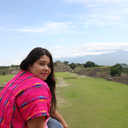
If you think the view from the parking lot is breathtaking, wait until you start climbing the dunes, some of them up to 10 ft high, because it will take your breath away, literally! Don't forget to bring water!! That's me on the right side of the picture, notice the hikers on the left side, right above my shadow...

My friend Carolina leading the way!

After stopping at Furnace Creek Ranch for gas, more water and lunch, we continued our drive south to the Devil's Golf Course and Badwater Basin. The road to reach the Devil's Golf Course is unpaved, but I had no problem driving on it with my non-4x4 car. Once you arrive to the parking area the view is confusing. Hundreds of little peaks rising from the ground made out of salt! Be careful walking around them, they are rock hard and extremely sharp...

It's hard to imagine being below sea level, unless you were underwater, but Badwater Basin is 282 ft below sea level! There's even a little sign way up high in the mountain facing it that reads 'sea level.' It's pretty cool! It looks like you were walking on snow, but it's salt.


We decided to catch the sunset at Zabrieski Point. On our way there, we drove through Artist Drive. A one way scenic road that takes you near the base of hills that look like they have been watercolored. Zabrieski Point has an ample parking area. A short and easy hike up the hill gives you the most unreal and spectacular view! Perfect spot for sunset!!


On Sunday morning we went exploring north of Lone Pine, but I'll leave that for another post.
For more pics from our Death Valley adventures, check out my Instagram account (@squeakylily).
#tbt#death valley#alabama hills#eastern sierras#road trip#photojournalism#national park#national geographic#budget travel#instagram#lone pine#squeakylily
1 note
·
View note
Text
Worldwide Instameet 8
Instagram had a Worldwide Instameet last weekend (#wwim8), which is another way of saying 'get together, take pictures and let us in on the fun.' And so I did! In a crazy and funny group text I asked my allies, my fellow adventurers, my crew, where they wanted to go, and we decided on Abalone Cove Shoreline Park, in Rancho Palos Verdes.
It was my first time there. After a short hike down a hill, we hit the beach. It was a beautiful sight, uncrowded shoreline, tide pools to see marine life up close, and a cave or two to explore.
This is the view from the parking lot. It cost $5 to park and they only take cash.

Lots of marine life to marvel at, like this purple sea urchin.

Stacked rocks near one of the caves.

This is me, as captured by my friend Johnny. Behind me is the entrance to the cave.

My friend John, braving the waves and the chance of getting soaked, going inside the cave. The colors on these rocks are unreal!

To finish the day off, we drove a couple of miles down to the Point Vicente Lighthouse to watch the sunset. Look at this spectacle!

For more shots from this adventure check out my Instagram feed (@squeakylily).
#abalone cove#rancho palos verdes#los angeles#california#squeakylily#travel photography#wwim8#travel#adventures#photography#instagram
2 notes
·
View notes
Text
Hello, World!
My name is Gladys and I live in Los Angeles, CA.
I like going on adventures. Some small, some big. From a short walk, to a road trip. Down the street from my place, or three states away. Kids in tow, or sans kids. It doesn't matter the length or scale of it, I always have my camera in hand (lately, my iPhone 5s camera).
I love photography, also traveling. I'm a planner, a calendar keeper, but some of my best adventures have been spur of the moment decisions. Most of the moments are recorded on my Instagram (@squeakylily) account and I've decided I want to share more. Join me and lets see what new adventures we can find...

P.S. All pictures taken with my iPhone 5s, unless otherwise noted.
1 note
·
View note