# GlobalSelfie
Text

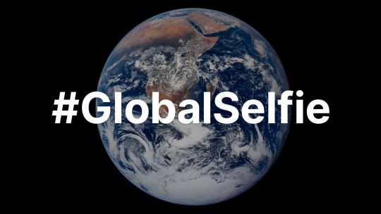
For Earth Day, we’re inviting you to take a moment to celebrate our wonderful water world, Earth. As far as we know, our Blue Marble is the only place in the universe with life, and that life depends on water. Snap a photo of yourself outside and tag it #GlobalSelfie – bonus points if your selfie features your favorite body of water! http://go.nasa.gov/3xFt0H0
Make sure to follow us on Tumblr for your regular dose of space!
2K notes
·
View notes


Text
How are you celebrating the day? Perhaps you're taking a global selfie today on your college campus for Earth Day! Join us on FreezeCrowd.com to freeze with your global selfie.💚🌏🌐
1 note
·
View note
Text
Share a photo of yourself in one of your favorite parts of our water world.
As far as we know, our Blue Marble is the only place in the universe with life, and that life depends on water.
Join us in celebrating #EarthDay by sharing a photo of yourself in
#Blue Marble#globalselfie#international mother language day#mother earth#get involved#NASA#your favorite parts of our water world
0 notes
Text
Join NASA in Celebrating Earth Day 2024 by Sharing a #GlobalSelfie
NASA invites you — and everyone else on the planet — to take part in a worldwide celebration of Earth Day with the agency’s #GlobalSelfie event. While NASA satellites constantly look at Earth from space, on Earth Day we’re asking you to step outside and take a picture of yourself in your corner of the […]
from NASA https://ift.tt/qieI5Q7
0 notes
Text
0 notes
Text
Our Beautiful Water World - NASA
New Post has been published on https://sunalei.org/news/our-beautiful-water-world-nasa/
Our Beautiful Water World - NASA

This Jan. 30, 2012 image of Earth was created from photographs taken by the Visible/Infrared Imager Radiometer Suite (VIIRS) instrument aboard the Suomi NPP satellite. Many features of North America and the Western Hemisphere are particularly visible. The composite was created from the data collected during four orbits of the robotic satellite taken earlier in January 2012 and digitally projected onto the globe.
VIIRS collects visible and infrared imagery along with global observations of Earth’s land, atmosphere, cryosphere, and ocean, extending observational records collected by similar instruments aboard previously launched satellites, such as NASA’s Moderate Resolution Imaging Spectroradiometer (MODIS) and NOAA’s Advanced Very High Resolution Radiometer (AVHRR).
Help us celebrate Earth Day by sharing a #GlobalSelfie.
Image Credit: NASA
0 notes
Link
Behold one of the more detailed images of Earth. This Blue Marble Earth montage—created from photographs taken by the Visible/Infrared Imager Radiometer Suite (VIIRS) instrument aboard the Suomi NPP satellite—shows many stunning details of our home planet.NASA This Jan. 30, 2012 image of Earth was created from photographs taken by the Visible/Infrared Imager Radiometer Suite (VIIRS) instrument aboard the Suomi NPP satellite. Many features of North America and the Western Hemisphere are particularly visible. The composite was created from the data collected during four orbits of the robotic satellite taken earlier in January 2012 and digitally projected onto the globe. VIIRS collects visible and infrared imagery along with global observations of Earth’s land, atmosphere, cryosphere, and ocean, extending observational records collected by similar instruments aboard previously launched satellites, such as NASA’s Moderate Resolution Imaging Spectroradiometer (MODIS) and NOAA’s Advanced Very High Resolution Radiometer (AVHRR). Help us celebrate Earth Day by sharing a #GlobalSelfie. Image Credit: NASA
0 notes
Photo

Happy Earth Day. If we don’t take care of it. It will go away. #happyearthday #globalselfie #forsythpersonaltraining (at Walnut Creek, California) https://www.instagram.com/p/BwkTHT8pLg-/?utm_source=ig_tumblr_share&igshid=1br86xssv9p0t
0 notes
Photo

Paint night! #paintnight #paintnite #painting #globalselfie #newbedford #newbedfordma #newbedfordmass #newbedfordguide #newbedfordharbor (at City of New Bedford)
#newbedfordmass#paintnight#newbedford#globalselfie#painting#newbedfordharbor#paintnite#newbedfordguide#newbedfordma
1 note
·
View note


Photo

Killing time 🔯 . . #globalselfie #owl #animalspirit #souhaiter #godzillarge
2 notes
·
View notes
Last Seen Blogs

rosemaze-reveries
love’s last vestige

dsb40
DSB: Only 18+

namemejulora
Untitled

thingssssssssssss
VIVO Y SIENTO COSAS QUE ES DIFICIL EXPLICAR

hatdieubinhphuocvietnam
Hạt Điều Bình Phước, Việt Nam