#52hikeschallenge
Text
Today I didn't go hiking, strictly speaking, but rather I made a pilgrimage.
Accompanied by a protestant priest and a catholic Father, a group of pilgrims trough all age groups followed part of the route on which protestant bible translations were smuggled during the counter-reformation.
We were stepping on historical ground, which became clear right away, when we saw 3000 year old burial mounds, or followed along a path built by the Romans (if you look closely you can see the tracks the wheels of the carts have worn into the stone)


After a while we entered an area that had been devastated by a massive rockslide more than 600 years ago. Today the area is a nature park famed for its biodiversity.

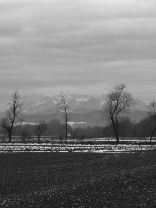
This is the mountain from which the rock masses tumbled down:

The weather was perfect.
Hiked distance: 17 km / 10,56 miles
⬆️695 m / 2280 ft ⬇️ 540 m / 1771 ft
3 notes
·
View notes
Photo

Hike #30, Harrod's Creek Park, Prospect, KY. Orange, Red, Green and Blue Trails, ~4 miles With softly rippling currents, lush foliage and scenic footbridges, this park is an Impressionist's paradise. Nice and easy first hike back after a month. I'll be doing two a week until I'm caught up, which suits me just fine as Autumn is about to begin. #52hikeschallenge #52hikechallenge #52hikes #hiking #nature #forest #kentucky #louisville #ohiovalley #midwest #creek (at Harrods Creek, Kentucky) https://www.instagram.com/p/CUBSU5fFaIm/?utm_medium=tumblr
#30#52hikeschallenge#52hikechallenge#52hikes#hiking#nature#forest#kentucky#louisville#ohiovalley#midwest#creek
4 notes
·
View notes
Photo
Today was a super nice day for a fun hike! #hike3 for me and #hike2 for mom on our @52hikechallenge did you get outside this weekend? What did you do!? #52hikechallenge2020 #52hikeschallenge #momanddaughter #hiking #hikingadventure #stlhiking #stlhikingtrails #missouristateparks #missouriadventure #missouriparks #missouriparksandrecreation #hikingdogsofinstagram #hiking_hobby #hikingviews #sculpturepark #laumeier #laumeiersculpturepark #laumeierstl #stlparks #laumeierscultpurepark #loveinjune16 #hikingfamily #nature #discoverunder5k #discoverunder3k #missouri #missourihiking #challengeyourself (at Laumeier Sculpture Park) https://www.instagram.com/p/B87pMohDyLj/?igshid=1f1menqxlbzh3
#hike3#hike2#52hikechallenge2020#52hikeschallenge#momanddaughter#hiking#hikingadventure#stlhiking#stlhikingtrails#missouristateparks#missouriadventure#missouriparks#missouriparksandrecreation#hikingdogsofinstagram#hiking_hobby#hikingviews#sculpturepark#laumeier#laumeiersculpturepark#laumeierstl#stlparks#laumeierscultpurepark#loveinjune16#hikingfamily#nature#discoverunder5k#discoverunder3k#missouri#missourihiking#challengeyourself
0 notes
Text
I need to bow out of the 52hikeschallenge.
My mum (91 years old!) fell and broke her leg, so I doubt I will be able to go hiking as frequently as I had planned in the next couple of months.
There will be hikes as I need them to destress, and I will post about them, but right now I don't know how things will develop.
4 notes
·
View notes
Photo

Booked my permit for the West Coast Trail yesterday! Vancouver Island, here I- ... well, I’d better wait a few months. The trail doesn’t open until May. #hikingplans #52hikeschallenge . . . #mecstaffer #goodtimesoutside #explorebc #instagood #OptOutside #natureisamazing #onserejointdehors #bcferries #britishcolumbia #beautifulbc #52hikeschallenge2018 #coastsalishterritory #pacificnorthwest #nature #outdoors #adventure #hikinglife #landscape #mountains #view #sunrise #bchikes #everydayadventures #liveoutdoors #silhouette #hiking #hikingadventures
#hiking#onserejointdehors#optoutside#view#hikingplans#pacificnorthwest#britishcolumbia#mountains#bcferries#natureisamazing#nature#hikinglife#mecstaffer#everydayadventures#silhouette#52hikeschallenge#coastsalishterritory#instagood#sunrise#beautifulbc#goodtimesoutside#52hikeschallenge2018#liveoutdoors#landscape#explorebc#adventure#hikingadventures#bchikes#outdoors
0 notes
Photo

#Repost @sarah_daydreams ・・・ 4.5 miles on the PCT today. Absolutely love this trail. I decided to do the #52HikesChallenge this year, I’m going to try my best to do 52 *different* hikes. I did the challenge in 2016 that way and it really encouraged me to get out and explore new trails, so here we go! #Hike1, the PCT along Deep Creek in Lake Arrowhead. Who else is doing the @52hikechallenge this year? ❤️ #happytrails . . . . . . . #pct #pacificcresttrail #deepcreek #lakearrowhead #sanbernardinomountains #sanbernardinonationalforest #girlswhohike #womenwhohike #womenwhoexplore #adventuregirls #peoplewhoadventure #radgirlslife #mountaingirls #forceofnature #optoutside #hikingadventures #themountainsarecalling #hiker #hikelikeawoman #hikelikeagirl #hikeitout #happyhiker #naturelovers
#sanbernardinonationalforest#hike1#hikelikeagirl#mountaingirls#hikingadventures#pacificcresttrail#themountainsarecalling#womenwhoexplore#womenwhohike#naturelovers#hikelikeawoman#hikeitout#sanbernardinomountains#pct#hiker#peoplewhoadventure#forceofnature#deepcreek#happytrails#lakearrowhead#happyhiker#radgirlslife#52hikeschallenge#adventuregirls#girlswhohike#repost#optoutside
2 notes
·
View notes
Text
Today I hiked a bit farther away from home than usual. I took the train to get to the starting point of today's hike, and at the endpoint a member of the group I was hiking with gave me a ride to the nearest train station so I could get home again.


I brushed the border to of Slovenia at one point (the big white stone in the right picture in the middle row marks the state border). 30 years ago this place was guarded. I'm rather glad borders around here are not that significant anymore.
Hiked distance: 17 km / 10,6 miles
(plus the distance I walked to the train station)
⬆️ 810 m / 2657 ft ⬇️ 880 m / 2887 ft
#Hiking#hiking in march#hiking in austria#hiking in carinthia#52hikeschallenge#52hikeschallenge2022#Hike9
3 notes
·
View notes
Text
Husband and I did a loop around the wine yards late in the afternoon. The trail runs past our house, so we basically always walk it when we want to go outside for a quick hike. ( e.g. when we procrastinated and it's too late to do anything else)

Nature is still dormant, but I already noticed some bushes and trees preparing to spread pollen. Pollen are the part of spring I'm not really looking forward to. Just thinking of them causes me to sneeze.
Distance: 6 km / 3,7 miles
⬆️ 240 m / 778 ft
⬇️ 235 m / 770 ft
#Apisa-b hikes#52hikeschallenge2022#52hikeschallenge#hiking in austria#hiking in carinthia#Hiking in February
4 notes
·
View notes
Text
After two weeks in which I first self-isolated and then was just too tired to go for walks, the weather was too fine to not go outside for a little while last Sunday.
I combined a visit to mum with a walk along the river.

On the lefthand side of the river runs a dirt road, which is needed to reach the farmland, but is also a popular running trail, is used as a bridle path, and is even part of a pilgrimage trail (the parts of that trail running through our valley I fully intend to walk later in the year), while on the ride hand side the river is accompanied by a biking trail.
The small cluster of trees you can see in the picture above is a small nature reservate. As a result of ground subsidence due to coal mining some shallow ponds formed, which are now a habitat for various bird species (app. 200(!) species).

Here I turned around this time, as the sun was already going down.
The first signs of spring can already be noticed. The grass is starting to look green again, and hazel bushes are in full bloom (much to my chagrin, as I'm allergic to them), but I didn't see any spring flowes yet.
Hiked distance: 12,5 km / 7,8 miles
⬆️110 m / 360 ft ⬇️ 120 m / 393 ft
#Apisa-b hikes#52hikeschallenge2022#52hikeschallenge#hiking#hiking in austria#landscape photography#nature photography#Hiking in February#hiking in carinthia#Hike7
3 notes
·
View notes
Text
This is what I collected during today's stroll on a city-near trail.

The trash that can be found on or next to trails always causes my blood pressure to skyrocket.
Everyone tends to occasionally drop something, be it a candy wrapper or a used tissue, but what can be found out there is far more than what people loose accidentally. It's the deliberate littering that angers me so.
Why is it impossible to take the empty soda / beer can home, after one enjoyed the drink? The cans are dangerous for animals! Every year many animals die painfully because they swallow pieces of cans and the metal cut them open internally.
And don't get me started on cigarette butts! A butt takes up to 15 years to decompose, and poisons the soil and our water in the process. And yet nobody seems to care. Flipping the butts on the ground is apparently acceptable behaviour.
I only can ask my fellow hikers:
Leave no trace but footprints. Take nothing with you but memories.
2 notes
·
View notes
Text
New Year’s Day hike
It’s become sort of a New Year’s Day tradition for me to hike up to a certain landmark - a wayside shrine - on the first day of the new year.
Overall the weather is far too warm in my country. It is said that it is the warmest New Year’s Day since the beginning of weather recording. But the valley I live in is different - due to inversion we had thick fog and temperatures around freezing point for the last couple of days, and I was hungry for some sun and blue skies, I knew were lurking above the fog.
Around mid-afternoon I packed my backback and ventured out into the gloomy weather.

As I steadily climbed up, I began to convince myself that the sky started to change from pure white to be slightly blue, and so I pushed on.

And lo and behold, I managed to break through the fog barrier just in time to watch the sun go down.

Of course convincing myself to go down into the fog was not easy, and I had to use my headlamp for the last few kilometers, as it was already dark by the time I got back down into the valley.
Hiked distance: 8,2 km / 5 miles,
elevation gain: 420 m / ~1370 ft
#52hikeschallenge#hike1#apisa-b hikes#hiking#52hikeschallenge2022#hiking in austria#hiking in carinthia#landscape photography#nature photography
4 notes
·
View notes
Text
An uninspired walk in uninspiring weather.
Today I nearly had to force myself to go outside. After yesterday's Foehn-storm it was not really advisable to go exploring in the woods, so I decided to take a walk along the river.
The trail along the river is not the most riveting trail even in spring, but right now it is downright drairy. The shrubbery separating the trail from the river is naked and looks dead, and the fields on the other side of the trail are empty.
Add the overcast sky, and the vibe was very November-y.
Walked distance: 11,3 km / 7 miles
Elevation gain: 165m / 540 ft (nearly none)
3 notes
·
View notes
Text
I hate taking the car to reach trails I like to walk - at least when those trails are near the place where I live. Often it can't be helped, as public transport is scarce in general and non-existant on weekends. Today I chose a trail that an be reached by bike.
I don't think I've taken my bike for a spin this early in the season before. Normally my first bike ride of the year takes place around Easter.
When I started out after lunch, it was still sunny and not too cold for biking (I'm not fond of biking in freezing temperatures)


From where I parked my bike, I took a trail I discovered through a hiking app and thought it might be a nice Nordic Walking trail in the warmer season.
This little brook looks very peaceful here, but is responsible for severe flooding on a regular basis. After thunderstorms in the mountains it turns into a raging torrent.
What I didn't expect was that today's walk would turn into a snow hike.

The trail follows the brook into a side-valley with not much sun exposure - hence the snow.
Anyway, I surely will revisit this trail in spring, once the snow has melted.
Biked distance: 11,19 km / 6,95 miles 🚴♀️
⬆️ 85 m / 278 ft ⬇️ 90 m / 295 ft
Hiked distance: 6,46 km / 4 miles 👣
⬇️205 m / 672 ft ⬆️ 200 m / 656 ft
#Apisa-b hikes#hiking#52hikeschallenge2022#52hikeschallenge#Hike6#Hiking in February#hiking in austria#hiking in carinthia
2 notes
·
View notes
Text
I have no qualms to count yesterday's outing towards the #52hikeschallenge and I have the sore muscles to back that up.
Once again the weather was foggy down in the valley, but a bit higher up the skies were blue.
I took me a while to motivate myself to get out, so I started a bit late. I drove up to a landmark that often is a turning point at hikes I literally start at my doorstep: the little chapel on the left.


From here I followed a clearly marked trail for a couple of kilometers, until the setting sun reminded me that I should probably turn around. At the wayside cross in the right picture I rested a bit and enjoyed the view.

Hiked distance: 7,3 km / 4,5 miles
Elevation gain: 395 m / 1295 ft
#52hikeschallenge#52hikeschallenge2022#Hike3#hiking in austria#hiking in carinthia#hiking#nature photography#landscape photography
2 notes
·
View notes
Text
Husband and I both took a mental health day, as we both have worked far too many hours in the last couple of weeks, and the workload doesn't seem to ease off, but rather increases.
So we slept in, had lunch, and then husband suggested going for a walk, as it was a sunny day. I warned him about the frozen snow on the trail he'd chosen (his favourite city-near trail, wich we do quite often), but he didn''t believe me.
I packed snow spikes, but he doesn't have those (yet).
I'd barely walked one kilometer before I put the snow spikes on. Watching me walk those icy trails without a hitch convinced him to buy some for himself as well.

The trail might look harmless, but combined with the incline it's treacherous. Having to think where to put your foot with every step is exhausting.
Walked distance: 7,1 km / 4,4 miles
Elevation gain: 285 m / 935 ft
1 note
·
View note
Photo

Hike #23 - General Butler State Park, Carrollton, KY. Butler Turpin House and Overlook Fossil Trail, 5.6 miles Some people have told me they wouldn't want to take up hiking, because in a forest there are things like snakes, spiders, mosquitos, flies, ticks, mud, blowdowns and big hills to climb. This is true. But there are also butterflies, lizards, frogs, birds, deer, crystal clear streams, waterfalls, beds of moss and pine needles softer than carpet, flowers, glades full of sunshine and big, beautiful trees. You have to take the good and the bad together, as in life. #52hikeschallenge #52hikechallenge #52hikes #forest #woods #nature #kentucky #midwest #outdoors #hiking #spring (at General Butler State Resort Park) https://www.instagram.com/p/CPqpNKXlFFX/?utm_medium=tumblr
#23#52hikeschallenge#52hikechallenge#52hikes#forest#woods#nature#kentucky#midwest#outdoors#hiking#spring
3 notes
·
View notes
Last Seen Blogs
traditionalarcherytimes
Traditional Archery Times

coisas-vanessarianas
Coisas Vanessarianas

darkflowerpartywobbler
Untitled

iamcandicewilhard
candie

denizmavisiigibii
Deniz‘i çok sev ⚓︎