#Caribbean Rainfall
Text
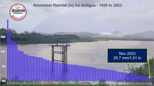
Near Record-Breaking Dry November Followed Near Record-Breaking Wet October
Dale C. S. Destin – Published 22 December 2023 |
In the span of two months, Antigua experienced a meteorological rollercoaster, going from a near-record-breaking wet October to a near-record-breaking dry November. With an island-average total of 25.7 mm (1.01 in), November 2023 has emerged as the second driest such month on record. It fell just short of the historic low set back in 1947, a…
View On WordPress
#Antigua Rainfall#Antigua Weather#Caribbean Rainfall#Caribbean Weather#Extreme Rainfall#November Rainfall
1 note
·
View note
Text
Atlantic Tropical Weather Outlook issued by the National Hurricane Center in Miami, FL, USA
2024-06-28, 20:00 EDT

Active Systems: The National Hurricane Center is issuing advisories on newly formed Tropical Depression Two, located over the central tropical Atlantic Ocean.
Northwestern Caribbean/Southwestern Gulf of Mexico (AL94): A broad area of low pressure over the northwestern Caribbean Sea continues to produce widespread but disorganized shower and thunderstorm activity. Development of this low is not anticipated before it moves inland over the Yucatan Peninsula on Saturday. The system is then forecast to move west-northwestward, emerging over the Bay of Campeche Saturday night or early Sunday, where conditions appear generally conducive for further development. A tropical depression could form before the system moves inland again early next week over Mexico. Regardless of development, heavy rainfall associated with the area of low pressure will affect portions of Central America and Mexico through early next week.
* Formation chance through 48 hours...medium...40 percent.
* Formation chance through 7 days...medium...40 percent.
Eastern Tropical Atlantic: A tropical wave located several hundred miles south-southwest of the Cabo Verde Islands is producing an area of disorganized showers and thunderstorms. Environmental conditions appear generally conducive for additional development of this system, and a tropical depression could form by the middle of next week while it moves generally westward at 15 to 20 mph across the eastern and central tropical Atlantic.
* Formation chance through 48 hours...low...near 0 percent.
* Formation chance through 7 days...medium...40 percent.
&& Public Advisories on Tropical Depression Two are issued under WMO header WTNT32 KNHC and under AWIPS header MIATCPAT2. Forecast/Advisories on Tropical Depression Two are issued under WMO header WTNT22 KNHC and under AWIPS header MIATCMAT2.
$$ Forecaster Papin
#bot post#meteorology#weather#tropical weather#tropical storm#tropical depression#hurricane#atlantic#atlantic ocean#caribbean#gulf of mexico#noaa#national oceanic and atmospheric administration#nhc#national hurricane center
7 notes
·
View notes
Text
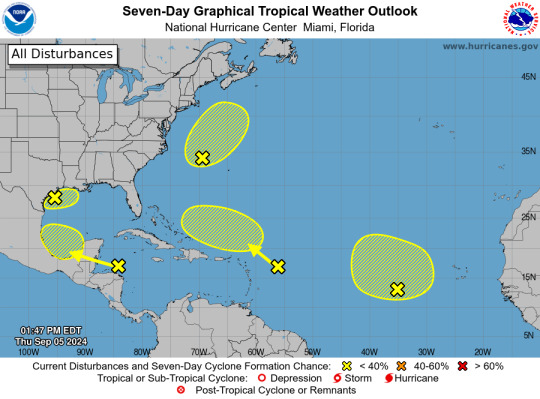
ZCZC MIATWOAT ALL
TTAA00 KNHC DDHHMM
Tropical Weather Outlook
NWS National Hurricane Center Miami FL
200 PM EDT Thu Sep 5 2024
For the North Atlantic...Caribbean Sea and the Gulf of Mexico:
1. Northwest Gulf of Mexico:
A large area of showers and thunderstorms continue in association
with a broad area of low pressure interacting with a weak frontal
boundary located over the northwestern Gulf of Mexico. Upper-level
winds are expected to become less conducive for development by late
Friday and Saturday as another frontal boundary approaches the
system. Although development is unlikely, heavy rainfall is
expected across portions of the northern Gulf Coast during the next
day or so. Additional information on this system can be found in
products issued by your local National Weather Service Forecast
Office.
* Formation chance through 48 hours...low...10 percent.
* Formation chance through 7 days...low...10 percent.
2. Northwestern Atlantic (AL99):
Showers and thunderstorms have become better organized in
association with a non-tropical area of low pressure located a few
hundred miles east of North Carolina, and recent satellite data
indicates the system is producing winds to near gale-force. This
system could acquire some tropical or subtropical characteristics
over the next day or two while it moves generally
north-northeastward, remaining offshore of the northeastern United
States. Once the low moves over cooler waters by early Saturday,
further development is not expected. Additional information on this
system, including gale warnings, can be found in High Seas Forecasts
issued by the National Weather Service.
* Formation chance through 48 hours...low...30 percent.
* Formation chance through 7 days...low...30 percent.
3. Eastern Tropical Atlantic:
An elongated trough of low pressure over the eastern tropical
Atlantic is producing limited shower activity. Development is not
expected through this weekend while the system moves little. Some
slow development appears possible early next week when the
disturbance begins moving slowly northwestward.
* Formation chance through 48 hours...low...near 0 percent.
* Formation chance through 7 days...low...20 percent.
4. Northwestern Caribbean Sea and Southwestern Gulf of Mexico:
Shower and thunderstorm activity remains disorganized in
association with a westward-moving tropical wave located over the
western Caribbean Sea. Development is not expected before the
system reaches Belize and the Yucatan Peninsula by early Friday.
Some gradual development is possible late in the weekend into early
next week after the system emerges over the southwestern Gulf of
Mexico.
* Formation chance through 48 hours...low...near 0 percent.
* Formation chance through 7 days...low...20 percent.
5. Central Tropical Atlantic:
Another tropical wave located a few hundred miles east of the
Leeward Islands is producing limited shower and thunderstorm
activity. Strong upper-level winds are expected to inhibit
development of this system during the next few days while it moves
west-northwestward at 10 to 15 mph. By early next week,
environmental conditions could become more conducive for some slow
development while the system moves over the southwestern Atlantic
Ocean.
* Formation chance through 48 hours...low...near 0 percent.
* Formation chance through 7 days...low...10 percent.
High Seas Forecasts are issued by the National Weather Service
under AWIPS header NFDHSFAT1 and WMO header FZNT01 KWBC, and online
at ocean.weather.gov/shtml/NFDHSFAT1.php
Forecaster Hagen/Delgado
2 notes
·
View notes
Text
The North Atlantic Ocean has been running a fever for months, with surface temperatures at or near record highs. But cooling along the equator in both the Atlantic and eastern Pacific may finally be starting to bring some relief, particularly for vulnerable coral reef ecosystems.
This cooling comes from two climate phenomena with similar names: La Niña, which forms in the tropical Pacific, and the less well-known Atlantic Niña.
Both can affect the Atlantic hurricane season. While La Niña tends to bring conditions ideal for Atlantic hurricanes, the less powerful Atlantic Niña has the potential to reduce some of the hurricane risk.
We’re ocean and atmospheric scientists who study this type of climate phenomenon. It’s rare to see both Niñas at the same time, yet in August 2024, both appeared to be developing. Let’s take a closer look at what that means.
La Niña and Its Cousin, Atlantic Niña
La Niña is part of the El Niño–Southern Oscillation, a well-known climate phenomenon that has widespread effects on climate and weather around the world.
During La Niña, sea surface temperatures in the tropical Pacific dip below normal. Easterly trade winds then strengthen, allowing more cool water to well up along the equator off South America. That cooling affects the atmosphere in ways that reverberate across the planet. Some areas become stormier and others drier during La Niña, and the wind shear that can tear apart Atlantic hurricanes tends to weaken.
La Niña and its warmer opposite, El Niño, oscillate every three to four years or so.
A similar climate phenomenon, Atlantic Niña, occurs in the Atlantic Ocean but at a much smaller scale and amplitude. It typically peaks around July or August and tends to have a shorter duration than its Pacific cousin, and much more modest and local impacts. Atlantic Niñas generally have the opposite effect of Atlantic Niños, which tend to reduce rainfall over Africa’s Sahel region and increase rainfall in Brazil and the countries that surround the Gulf of Guinea, such as Ghana, Nigeria, and Cameroon.
While much weaker than their Pacific counterpart, Atlantic Niñas can, however, partially counteract La Niñas by weakening summer winds that help drive the upwelling that cools the eastern Pacific.
Why Are Both Happening Now?
In July and August 2024, meteorologists noted cooling that appeared to be the development of an Atlantic Niña along the equator. The winds at the ocean surface had been weak through most of the summer, and sea surface temperatures there were quite warm until early June, so signs of an Atlantic Niña emerging were a surprise.
At the same time, waters along the equator in the eastern Pacific were also cooling, with La Niña conditions expected there by October or November.
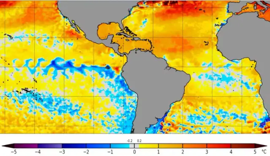
A map of sea surface temperature anomalies shows cooling along the tropical Atlantic and eastern Pacific regions, but much warmer than average temperatures in the Caribbean. Photograph: NOAA Coral Reef Watch
Getting a Pacific-Atlantic Niña combination is rare but not impossible. It’s like finding two different pendulums that are weakly coupled to swing in opposite directions moving together in time. The combinations of La Niña and Atlantic Niño, or El Niño and Atlantic Niña are more common.
Good News or Bad for Hurricane Season?
An Atlantic Niña may initially suggest good news for those living in hurricane-prone areas.
Cooler than average waters off the coast of Africa can suppress the formation of African easterly waves. These are clusters of thunderstorm activity that can form into tropical disturbances and eventually tropical storms or hurricanes.
Tropical storms draw energy from the process of evaporating water associated with warm sea surface temperatures. So, cooling in the tropical Atlantic could weaken this process. That would leave less energy for the thunderstorms, which would reduce the probability of a tropical cyclone forming.
However, the NOAA takes all factors into account when it updates its Atlantic hurricane season outlook, released in early August, and it still anticipates an extremely active 2024 season. Tropical storm season typically peaks in early to mid-September.

Two reasons are behind the busy forecast: The near record-breaking warm sea surface temperatures in much of the North Atlantic can strengthen hurricanes. And the expected development of a La Niña in the Pacific tends to weaken wind shear—the change in wind speed with height that can tear apart hurricanes. La Niña’s much stronger effects can override any impacts associated with the Atlantic Niña.
Exacerbating the Problem: Global Warming
The past two years have seen exceptionally high ocean temperatures in the Atlantic and around much of the world’s oceans. The two Niñas are likely to contribute some cooling relief for certain regions, but it may not last long.
In addition to these cycles, the global warming trend caused by rising greenhouse gas emissions is raising the baseline temperatures and can fuel major hurricanes.
6 notes
·
View notes
Text
The most-recent National Hurricane Center (NHC) forecast shows winds related to Hurricane Beryl arriving in Texas on Saturday night.
Beryl strengthened into a hurricane on Saturday, becoming June’s easternmost major hurricane in the Atlantic. The storm underwent rapid intensification and became a Category 4 hurricane as soon as its wind speeds reached 130 miles per hour. The system temporarily weakened to a Category 3 before strengthening again, with maximum winds documented at 150 mph when it made landfall in the Windward Islands on Monday morning.
At one point, Hurricane Beryl was categorized as a Category 5, but it has since weakened again to a Category 4, with wind speeds at 145 mph.
The storm continues to tear through the Caribbean, and the NHC expects it to arrive in Jamaica on Wednesday afternoon. It will continue its progress toward the Cayman Islands and arrive there early on Thursday.
“Devastating hurricane-force winds, life-threatening storm surge, and damaging waves are expected,” the most-recent warning said. “Life-threatening flash flooding and mudslides from heavy rainfall are expected over much of Jamaica and southern Haiti through today.”
2 notes
·
View notes
Text

https://www.reuters.com/world/americas/least-12-dead-suspected-attempt-rescue-son-mexican-cartel-hitman-2024-01-22/
2 notes
·
View notes
Text
Hotter sea surface temperatures can lead to more evaporation and thus more rainfall. It can change wind patterns, so some places can get wetter while others get drier. Meanwhile, more heat causes the ocean itself to expand, which already accounts for one-third to one-half of global sea level rise.
Water temperature has huge effects on life in the ocean, too. As water heats up, it holds onto less oxygen and can suffocate fish. Hot water was a factor in thousands of dead Menhaden fish washing up on a beach in Texas earlier this month.
Warm water at the surface also slows upwelling, a critical mechanism that brings nutrients from deep in the ocean to the surface, nourishing life. Half of the world’s fish are caught in upwelling regions, so higher sea surface temperatures could lower the output of fisheries.
Another consequence of higher temperatures is that it makes water more acidic, accelerating ongoing ocean acidification that’s occurring as the seas absorb more carbon dioxide. And along with fertilizer runoff, hotter temperatures in the Atlantic, specifically, are contributing to record blooms of sargassum, a smelly, toxic seaweed that’s now fouling beaches in Florida and in the Caribbean.
This is happening on top of all the other ways humans are stressing the ocean: overfishing, pollution, and habitat destruction.
2 notes
·
View notes
Text
You probably knew about the Bronze Age Collapse, but did you know about the 6200 B.C.E. collapse?
"In about 6200 B.C., huge meltwater accumulations undermined the retreating Laurentide ice sheet in northern Canada. At a certain point, the huge ice sheet imploded, sending a massive outflow of meltwater cascading southward to the Gulf of Mexico. Another freshwater pulse rushed into the North Atlantic, perhaps as strong as that produced by the draining of Lake Agassiz at the onset of the Younger Dryas. Almost immediately, the ocean conveyor belt slowed perceptibly, and even stopped for as long as four centuries. Much colder, drier conditions, similar to those of the Younger Dryas, descended on Europe. The moist westerly air masses that brought rainfall to the eastern Mediterranean gave way to cold northerly flows. The Balkans and eastern Mediterranean suffered severe droughts, just as they had four thousand years earlier. The 400-year Mini Ice Age was a global event, visible in the Carioco deep-sea core in the southeastern Caribbean, in North African lake beds, and even in the heart of the Western Pacific Warm Pool, which at present has the highest mean sea surface temperatures in the world. Cores drilled into an ancient coral reef in Indonesia show an abrupt sea surface cooling of about 3 degrees Centigrade.
Most important of all, the Laurentide collapse triggered a rapid rise in the world's oceans. By 6200 B.C., the waters of the North Sea were rising 46 millimeters annually. Huge tracts of southern Scandinavia had vanished under water. Britain was finally severed from the continent. To the south, the Sea of Marmara came ever closer to bursting its banks.
For four centuries, southeastern Europe, Anatolia, and the eastern Mediterranean suffered under prolonged drought. Lake levels fell dramatically; some lakes dried up completely. Rivers and streams withered in the face of the wave of aridity that swept down from the north. Oak and pistachio forests again retreated across the parched landscape as temperatures sank rapidly.
History repeated itself, but with a difference. During the Younger Dryas, many communities in the forest belt had turned to cultivating wild grasses. Within a few generations they had become full-time farmers, growing cereals on such carefully selected and well-watered soils as they could find. When the Atlantic conveyor switched on again, farming spread rapidly throughout the Levant and into the far corners of Anatolia. Now, with renewed drought, hundreds of farming villages saw their crops wither in their gardens, among them obsidian-rich Catalhoyuk. Some settlements dwindled to a mere handful of inhabitants or turned to sheep herding as a means of survival. Others were simply abandoned. Hungry farmers retreated to the few rivers and streams that still flowed and to the shores of the much-shrunken lakes.
...
In 5800 B.C., the Atlantic circulation kicked in anew, and the warm years abruptly resumed. Once again, moist westerly air flows reached the eastern Mediterranean and the Balkans. The seesaw of the North Atlantic Oscillation remained firmly in a "high" mode, with low pressure over Iceland and a high over the Azores. Persistent westerly winds brought heat from the Atlantic's surface to the heart of Europe, keeping winter temperatures mild and summer rainfall plentiful. Temperate Europe entered a "climatic optimum" that would last for another two thousand years.
The farmers prospered in the newly mild climate. In the most fertile areas of northern Greece and southern Bulgaria, people used the same locations again and again for many centuries. The great Karanovo mound in Bulgaria ultimately reached a height of 12 meters and covered an area of some 300 square meters. Generations of farmers lived in these long-established settlements." - Brian Fagan, The Long Summer: How Climate Changed Civilization.
15 notes
·
View notes
Text
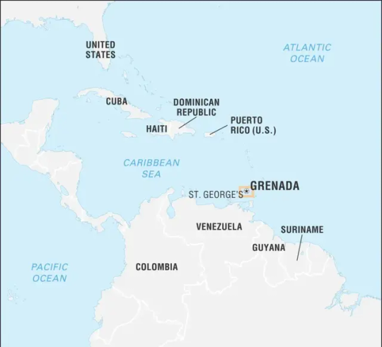
Grenada
Grenada, the spice island of the Caribbean, is a beautiful country with a rich culture and history. The country is located in the southeastern Caribbean Sea and consists of the island of Grenada and six other smaller islands.
The country has a population of approximately 111,454, and the official language is English. The capital city, St. George's, is a bustling port town with a picturesque harbor and a vibrant economy.
Grenada is known for its lush green forests, beautiful beaches, and vibrant culture. The country is famous for producing nutmeg, cinnamon, and other spices, which has earned it the nickname of the Spice Island.
The country's economy is primarily based on tourism, agriculture, and light manufacturing. Grenada's pristine beaches, crystal clear waters, and vibrant underwater world make it a sought-after destination for tourists. The country's rich history and culture also attract visitors from all around the globe.
Grenada has a tropical climate with consistent temperatures throughout the year. The country experiences rainfall between June and December, making it a perfect time to witness the flora and fauna in all its lush green glory.
Grenada's political system is a parliamentary democracy with a constitutional monarchy. The head of state is Queen Elizabeth II, who is represented in Grenada by a Governor-General. The country has a two-chamber parliament, consisting of the Senate and the House of Representatives.
Grenada is a picturesque and charming country with a rich culture, thriving economy, and warm hospitality. Its natural beauty, vibrant culture, and history make it a must-see destination for travelers from around the world.
Etymology
Grenada is a Caribbean country that is a popular tourist destination due to its natural beauty, warm hospitality, and rich cultural heritage. Its name is believed to have been derived from the ancient town of Granada in southern Spain.
When the first Spanish explorers arrived in the region in the late 15th century, they were reminded of their own hometowns, given the lush greenery and rugged terrain. The town of Granada in Andalusia, Spain, was a Moorish stronghold that was also known for its beauty and stunning landscapes. The name 'Grenada' was hence chosen as the name for the Caribbean island.
The origin of the name 'Granada' in Spain, however, is still a subject of debate. Some scholars believe that it may have been derived from the Arabic word 'qarnata,' which means 'hill of strangers,' because it was a refuge for Berber tribes that had migrated from North Africa. Others theorize that the name may have come from the Latin word for pomegranate, 'pomum granatum,' alluding to the fruit's reddish skin and juicy seeds.
Regardless of the exact origin of the name, Grenada embodies all the elements that its name represents - rugged peaks, lush valleys, exotic flora, and breathtaking beauty. It is no wonder that the island nation's name has become synonymous with paradise, attracting visitors from all over the world.
History
Grenada's history dates back to 200 B.C., with evidence of Amerindian settlements on the island. The Caribs, who were the last to inhabit the island, called it “Camahogne,” meaning “Island of Spice,” due to the abundance of nutmeg, cloves, ginger, and other spices.
Christopher Columbus first sighted Grenada in 1498 and named it Concepción. Over the next two centuries, the island was alternately controlled by the French and British. In 1783, Britain officially took control of Grenada under the Treaty of Versailles.
The British introduced the African slave trade to the island, leading to the exploitation of enslaved individuals who worked in Grenada's sugarcane fields. The abolition of slavery in 1834 reduced demand for labour, prompting a shift towards cocoa and nutmeg production.
Grenada became independent in 1974, with Sir Eric Gairy as its first Prime Minister. However, in 1979, the New Jewel Movement (NJM), a Marxist party led by Maurice Bishop, overthrew Gairy's government in a coup. Bishop became Prime Minister and led a socialist regime until 1983, when a power struggle between him and members of his government led to his overthrow and execution.
In the same year, the U.S and Caribbean nations, under the banner of Operation Urgent Fury, invaded Grenada to restore order, resulting in the establishment of a new government. New elections were held in 1984, and the New National Party (NNP) emerged victorious, with Herbert Blaize becoming Prime Minister.
Sir Nicholas Brathwaite succeeded Blaize as Prime Minister in 1989, but the NRP lost power to the National Democratic Congress (NDC) led by Ben Jones in 1990. However, the NDC government faced severe economic decline, leading to the return of the NNP in the 1995 general elections. Keith Mitchell succeeded Brathwaite as Prime Minister, a position he has held intermittently since.
In 2004, Hurricane Ivan devastated Grenada, causing significant damage to infrastructure and agriculture. The island has since seen a steady recovery with support from international donors.
Today, Grenada remains a constitutional monarchy within the British Commonwealth with a Prime Minister as its head of government.
Geology
Geology is an integral aspect of Grenada's natural environment. Grenada is a volcanic island with a diverse geology that includes rocks, lava flows, and volcanic sediments. The island also features a range of geological structures, such as folded and faulted terranes, and a variety of mineral deposits.
Grenada's geology can be traced back millions of years. The island was formed during the Late Oligocene period when it emerged from the sea due to tectonic plate movements. The island's geology is primarily composed of volcanic masses that are the result of a series of volcanic eruptions. The volcanic rocks are mostly basaltic, andesitic, and dacitic in composition.
The island also features several types of sedimentary rocks that were formed by the accumulation of volcanic ash, mud, and sand. This includes the region's highly fertile tuff deposits, which are often used for agricultural purposes.
One of the most notable geological features in Grenada is its dormant volcano, Grand Etang. Located in the center of the island, the volcano is approximately 1,740 feet above sea level. The crater of Grand Etang contains a lake, which is of great hydrological importance to the island.
Grenada's geology also affects the island's natural resources. The presence of mineral deposits, such as bauxite, gold, and manganese, has led to mining activities in the past. However, conservation efforts have been put in place to safeguard these resources and protect the environment.
Grenada's geological features and composition bring about diverse terrain that is both visually stunning and important to the island's ecology. As such, efforts must be made to preserve and protect it.
Geography
Grenada is a Caribbean country located at the southern end of the Grenadines island chain. The country comprises the main island of Grenada and six smaller islands, Carriacou, Petite Martinique, Caille Island, Diamond Island, Large Island, and Ronde Island.
Grenada has a total land area of 344 square kilometers and stretches 34 kilometers from its northernmost point to its southernmost point. The country's topography is characterized by volcanic mountains, with Mount Saint Catherine being the highest peak at 840 meters.
The island is largely covered by rainforest, and its lush greenery is a testament to the fertile soil. Grenada's coast is dotted with stunning beaches, coral reefs, and beautiful offshore islands. The country's coastline is 121 kilometers long, with plenty of bays, headlands, and sheltered harbors.
One of the unique features of Grenada is its crater lake, Grand Etang. Located in the Granada National Park, this lake is surrounded by a breathtaking rainforest and is home to many species of tropical plants, birds, and wildlife.
The island is also home to many other water features, such as rivers, waterfalls, and hot springs. The Annandale Waterfall is one of the most popular tourist attractions in Grenada and is located in a lush tropical forest setting.
The island of Grenada is located in the hurricane belt, making it more prone to natural disasters such as hurricanes and tropical storms. As a result, the country has developed resilience and emergency management plans to manage these risks.
In terms of its physical characteristics, Grenada's topography and natural features make it a popular tourist destination. Its stunning beaches, tropical forests, and beautiful offshore islands attract many visitors each year. It's also a popular destination for adventure-seeking tourists due to its many water features and mountainous topography. Grenada's diverse range of natural wonders continues to capture the hearts of tourists and locals alike.
Ecology
Grenada is an ecological paradise, with an abundance of natural resources and diverse flora and fauna. Its environment is so pristine that the country has been dubbed the "Island of Spice" due to its abundant production of nutmeg, cinnamon, and other spices.
The island is home to a vast array of ecosystems, including rainforests, mangroves, coral reefs, and savannas. Its coastline also boasts a remarkable variety of marine life, including whales, dolphins, sea turtles, and colorful fish.
The natural resources of Grenada have played a significant role in the country's economy and its inhabitants' livelihood. Nutmegs and other spices, together with bananas, cocoa, and other tropical fruits, account for a significant portion of the country's exports. The island's volcanic soil and tropical climate are conducive to the growth of such crops, making Grenada a thriving agribusiness hub.
In recent years, Grenada's government has taken significant steps to preserve and protect the island's natural resources. One such initiative is the country's National Parks and Wildlife Sanctuaries, which cover approximately 20% of Grenada's land area.
These protected areas encompass a diverse range of ecosystems, including forests, wetlands, mangroves, and coral reefs. They also offer a haven for various species of wildlife, including the Grenada dove, the national bird of the island, which is endemic to Grenada.
Beyond the parks and wildlife sanctuaries, Grenada also has several attractions that allow visitors to experience its natural beauty firsthand. For example, Grand Etang National Park, located in the island's central mountainous region, is a popular destination for hikers and nature enthusiasts.
The park, which covers approximately 2,000 acres, is home to the Grand Etang Lake, which is a crater lake formed in the aftermath of a volcanic eruption. Visitors can also spot several species of wildlife, including Mona monkeys and parrots, while hiking through the rainforest.
In addition to its natural resources, Grenada is also actively promoting sustainable tourism. Ecotourism, in particular, is becoming increasingly popular, thanks to the island's diverse ecosystems and natural attractions. Several eco-friendly resorts and lodges have sprouted up in recent years, catering to tourists who are looking for a more environmentally conscious travel experience.
Grenada's commitment to preserving its natural resources and promoting sustainable tourism makes the island a compelling destination for nature lovers and eco-tourists alike.
Biodiversity
Grenada, a Caribbean country, has a rich and diverse biodiversity. The country's location, climate, and terrain provide a varied habitat for numerous flora and fauna species. From rainforests to coral reefs, Grenada boasts 1,115 species of plants, 150 species of birds, 21 species of reptiles, and 12 species of mammals, along with a variety of other creatures.
The lush rainforests of Grenada are home to a broad range of plant life, including mahogany, teak, and cedar trees. The trees are used for various purposes, such as construction, furniture making, and medicinal purposes. The country is also known for its nutmeg production, which is a vital part of its economy. Nutmeg trees are found throughout the island, and Grenada produces about 20% of the world's supply. Other spices such as cinnamon, ginger, and vanilla are also grown in Grenada.
Grenada also has a wide variety of animal species. The National Bird of Grenada is the Grenada dove, which is a beautiful and peaceful bird known for its bright colors and sweet call. The country also has an abundance of marine life, including sea turtles, dolphins, and coral reefs that provide a habitat for various fish species. The Levera National Park is an excellent place to observe wildlife, with many hiking trails and lookout points where visitors can see a wide range of animals, birds, and insects.
Grenada's rivers, lakes, and ponds are home to several species of fish that are also an essential part of the country's cuisine. The country also has an active fishing industry that provides fresh seafood to many restaurants and markets.
Grenada has several protected areas where rare and endangered species live and thrive. The Grand Etang National Park is an excellent example, where visitors can see various wildlife, such as the Mona Monkey and the Lesser Antillean Iguana, living in their natural habitats. The park also has several hiking trails and waterfalls that visitors can explore while enjoying the beautiful scenery.
Grenada has a rich and diverse biodiversity of flora and fauna species that make it a unique and beautiful country. The government of Grenada recognizes the importance of protecting and preserving the country's natural resources and has implemented various programs to promote environmental conservation. Visitors to Grenada can enjoy an exciting experience by exploring the country's wildlife and natural habitats.

Mona Monkey
Climate
Grenada, an island nation in the Caribbean, has a tropical climate with a generally constant temperature throughout the year. The average temperature in Grenada is around 27 degrees Celsius, making it a perfect holiday destination for those seeking warmth and sunshine. Nonetheless, Grenada's climate is influenced by various weather systems, which can bring sudden changes in temperatures and conditions.
One such weather system is the trade winds, which provide a cooling effect on the island. The north-east trade winds blow throughout the year, making Grenada's weather fairly stable. During April to October, the island experiences occasional showers and thunderstorms as a result of the Intertropical Convergence Zone (ITCZ). While the rainy season lasts from June until December, with the highest precipitation levels in September and October.
Grenada's climate has a significant impact on the country's ecosystems and agriculture. The warm, moist climate favors a diverse range of plants and wildlife thriving in the region, including rainforest, mangrove forests, and coral reefs. The island's tropical climate provides perfect growing conditions for crops such as bananas, cocoa, and nutmeg, which have contributed significantly to the country's economy over the years.
Despite Grenada's year-round warm weather, the island is not immune to climate change. Over the past few years, the country has experienced unprecedented droughts, sea-level rise, and increased frequency of extreme weather. These conditions have resulted in the loss of crops and property damage, which poses significant challenges to the country's tourism-dependent economy.
To address these concerns, Grenada has implemented several initiatives to mitigate climate change effects, including the establishment of a Climate Action and Awareness Fund, which finances renewable energy projects, sustainable agriculture, and forestry. The country has also developed a National Adaptation Plan to address loss and damage from climate change and to minimize the island's carbon footprint.
the tropical climate of Grenada is a significant attraction for tourists visiting the country. The warm weather, combined with the country's diverse ecosystem and agriculture, provides an excellent experience for visitors. However, it is important to recognize the potential impact of climate change on Grenada's economy and ecology. The Country must continue to implement initiatives to address environmental challenges, not only to protect the natural beauty of the island but also to ensure a sustainable future for generations to come.
Environmental Issues
Grenada, like many other countries in the Caribbean, is significantly impacted by climate change. The rise in sea levels, increased frequency and intensity of hurricanes, and erosion of beaches pose significant environmental challenges for Grenada.
One of the critical environmental challenges facing Grenada is deforestation, primarily caused by agriculture and logging activities. This has led to soil erosion, loss of biodiversity, and decreased water quality, all of which significantly impact the country's ecosystem.
Another significant challenge is the inadequate waste management system, which contributes to littering and pollution of water bodies. While steps have been taken to address this issue, such as the implementation of recycling programs and the operation of landfills, there is still a long way to go.
However, Grenada has also taken significant steps to tackle environmental issues through various initiatives. The country has implemented a National Energy Policy that aims to increase the use of renewable energy sources, such as solar and wind power, to reduce dependency on fossil fuels.
Grenada also received a grant to establish a geothermal power plant to harness the natural energy from the island’s volcanic activity to provide electricity.
The country has also taken significant steps to promote sustainable tourism, with many hotels and resorts implementing eco-friendly practices and initiatives, such as the use of solar power and the conservation of water.
The government has also placed strong emphasis on marine conservation, with the implementation of strict fishing guidelines and the establishment of the Moliniere-Beausejour Marine Protected Area.
while Grenada faces several environmental challenges, the country is taking significant steps to address these challenges through various initiatives. It is crucial for Grenada and the international community to continue to prioritize environmental protection to ensure a sustainable future for the country and the planet as a whole.
Politics
Grenada is a parliamentary democracy and a Commonwealth realm with the Queen of England as its constitutional Head of State. The Queen is represented by the Governor-General, who acts on her behalf. The political system of Grenada is based on the British parliamentary model, with a bicameral legislature consisting of an upper house, the Senate, and a lower house, the House of Representatives.
Read the full article
1 note
·
View note
Text
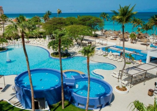
Best Time to Visit Aruba: A Comprehensive Guide
Aruba, the beautiful island nation in the southern Caribbean Sea, is a popular destination for tourists worldwide. Known for its beautiful beaches, clear blue waters, and warm climate, Aruba is a perfect vacation spot for those looking for a relaxing and fun-filled experience. However, planning the perfect trip to Aruba can be challenging, especially when choosing the right time to visit. This article will explore the best time to visit Aruba and what to expect during each season.
Source by: Pinterest
Aruba is a tropical island that enjoys sunny weather throughout the year. However, like many other destinations, it experiences different weather patterns at different times of the year. Therefore, the best time to visit Aruba depends on various factors, including weather, crowds, and prices. This guide will look in-depth at each season to help you choose the best time to visit Aruba.
High Season (December to April):
The high season in Aruba is between December and April, which is also the peak tourist season. The weather during this time is perfect for outdoor activities, with temperatures ranging between 75°F to 85°F. The clear skies and the humidity are low, making it ideal for beachgoers and water sports enthusiasts. However, since this is the peak season, the prices are high, and the crowds are more significant than usual. It is advisable to book your accommodations and activities in advance to avoid last-minute disappointments.
Shoulder Season (May to August):
The shoulder season in Aruba is between May and August. The weather is still warm, but there is a higher chance of rainfall, especially toward the end of August. The average temperature during this season ranges between 80°F to 88°F. The crowds are thinner than during the peak season, and the prices are more affordable. This is an excellent time to visit Aruba to enjoy outdoor activities while avoiding crowds.
Low Season (September to November):
The low season in Aruba is between September and November. The weather is humid and hot during this time, with temperatures ranging between 80°F to 90°F. The crowds are thin, and the prices are at their lowest this season. However, this is also the hurricane season, and there is a chance of tropical storms and hurricanes. Check the weather forecast regularly if you plan to visit Aruba during the low season.
Other Factors to Consider:
Apart from the weather, there are other factors to consider when planning your trip to Aruba. Some of these include
Events and Festivals:
Aruba is a hub of various cultural events and festivals throughout the year. If you are interested in experiencing the local culture, plan your visit to one of these events. Some popular festivals in Aruba include the Carnival, the International Film Festival, and the Soul Beach Music Festival.
Accommodation:
Aruba has several options for accommodation, ranging from luxury resorts to budget-friendly hotels. However, during the peak season, the prices of accommodations can be significantly higher. Therefore, booking your accommodations in advance is essential to avoid any last-minute disappointments.
Budget:
Aruba can be an expensive destination, especially during the peak season. Therefore, it is crucial to plan your budget accordingly. Research the prices of various activities, transportation, and food prices to create a realistic budget.
Conclusion:
Aruba is a beautiful destination offering everyone something. Whether you are a beach lover or an adventure enthusiast, there is always something to do in Aruba. The best time to visit Aruba depends on various factors, including weather and crowds.
3 notes
·
View notes
Text
Environment: The Mystery of the Healthy Coral Reef
A Reef Off the Coast of Honduras Should Be a Disaster. Instead it’s Thriving.
— By Juli Berwald | January 18, 2023

Tela Bay, Honduras is hot, polluted, and the last place anyone expected to find a thriving coral reef — but species dying out elsewhere in the Caribbean have continued to flourish in its waters. Photo by Antal Börcsök
Just over a decade ago, Antal and Alejandra Börcsök, newly-trained divers, heard about the rocas and, curiosity piqued, donned their scuba gear to explore. On the seafloor, rather than inorganic geologic forms, Antal and Alejandra discovered rocks that were very much alive. Everywhere they looked they saw growing, thriving coral.
The Börcsöks knew that Caribbean coral were plagued by disease, bleaching, and death. Yet as novice divers, they hadn’t seen enough to judge Tela’s coral. So, they invited friends who were active in coral monitoring to have a look.
Diseases that have ravaged other Caribbean reefs are apparently absent from Tela Bay.
Back on the surface, Antal recounts how their friends gushed, “That is the greatest reef we’ve ever visited! Is there more like that?” Now, having dived throughout more of Tela Bay than anyone, Antal can say that there is. In fact, there’s a lot more reef like that.
But why so much healthy coral exists is mysterious. “We should have nothing in Tela,” Antal says. “Everything that’s bad, we do in Tela.
That no one seems to have looked beneath the surface of Tela Bay before the Börcsöks did is probably because it’s such an unlikely spot for a thriving reef. About 10 kilometers west of Tela Bay, the Ulúa River, Honduras’ largest, empties into the Caribbean. It is loaded with sediments, which are typically problematic for coral. Sediments cloud sunlight required for photosynthesis by algae that live inside the coral’s tissues and supply as much as 90 percent of their nutrition. Sediments can also physically smother reefs.
“Not only that,” says Antal, “this is the place where the banana republic started.” In 1913 the United Fruit Company, which later became Chiquita, received concessions from the Honduran government to operate a rail line into the city of Tela as well as 162,000 hectares of land for banana plantations. Today the remains of the 1,000-foot wharf where boatloads of bananas were exported still rise above the surface of the water, but the banana trees have largely been replaced by African oil palms and those plantations have expanded.

DIVING DETECTIVES: Researchers want to know why this particular reef is doing so well when so many others are failing. Photo by Antal Börcsök.
Tela receives more than a meter of rainfall a year; as it runs into the bay it brings fertilizers from the plantations with it. Compounding the agricultural runoff is waste from Tela’s roughly 100,000 inhabitants. The city has no sanitation system except for pipes that run directly into the bay.
Corals evolved to live in the sea’s deserts, places where organic molecules like those in fertilizers and sewage are nearly absent. When exposed to elevated concentrations of these nitrogen-rich compounds, they often sicken.
Yet after more than a century of inundation by sediments, agricultural runoff, and sewage, the corals in Tela are unaccountably thriving. The reason the fishers avoid the reef is because it is so abundant and complex that small fish can hide from predation. Big fish don’t bother hunting there, and neither do the fishers.
Discovering the reef galvanized Antal and Alejandra. They started a project to protect it, and within two years saw the passage of a local law to do so. Their company, Tela Marine, partnered with an English tour operator, Project Wallacea, which helps graduate students develop field projects.
Dan Exton, the head of research at Operation Wallacea, recalls standing on the beach in Tela with Antal for the first time and thinking there couldn’t possibly be a coral reef beneath the murky water. “I almost cancelled the dive,” he said. But as soon as he descended, Exton saw “mind-blowing coral. I’d never seen a reef like that. Everywhere you looked, something unusual was happening.”
Since then, Exton has overseen the work of more than 500 students in Tela Bay; their findings confirm the unusual richness of the reef. Whereas at the nearby island of Utila, coral cover—the proportion of a reef’s surface where healthy coral grows—hovers around 20 percent, in Tela it remains more than threefold greater.
Elkhorn and staghorn coral species that are critically endangered in the rest of the Caribbean grow in rich thickets along the bay’s shores. Mountainous star coral, another endangered species, grows in massive plated colonies as big as backyard sheds. Lettuce corals unfurl in long, rich carpets. Their blades form tiny three-dimensional apartments for shrimp, snails, clams, worms, and tiny sea stars, and provide spaces where small fish can hide from predators.
“As Far As We Know, There Isn’t Any Other Reef in The World That Looks Like This.”
One important observation is that diseases that have ravaged other Caribbean reefs are apparently absent from Tela Bay.
Since 2014, stony coral tissue loss disease has decimated reefs throughout the Caribbean, melting more than 20 species of brain, maze, and pillar coral tissue like hot wax. These species are found in Tela Bay, yet no one has seen the disease there.
Here and there, the pick-up-sticks spines of sea urchins wave curiously from within crevasses. These clementine-sized urchins are critical to reef health, grazing algae that can easily overgrow coral. In the 1980s an epidemic wiped out urchins throughout the Caribbean, and they have never rebounded. In Tela Bay, the numbers of urchins remain at pre-pandemic levels, roughly 100 times more abundant than elsewhere in the region.
Another outlier are giant barrel sponges. On nearby Roatan, divers used to pose for pictures inside millennium-old sponges so big that the dive spot was referred to as “Texas,” because everything is so big in Texas. But in 2018, an affliction called orange band disease killed the ancient organisms in just four months. In Tela Bay, barrel sponges were unaffected.

SPINY GARDENERS: Sea urchins graze on algae that can easily overgrow coral, so they’re vital for a healthy reef. Disease wiped the urchins out across the Caribbean, but the urchins in Tela Bay remain untouched. Photo by Antal Börcsök.
One more threat facing reefs is heat. As Earth warms, half of all coral reefs are thought to have already succumbed to bleaching, in which a coral’s symbiotic algae departs the partnership, leaving the coral bereft of color and nutrition. Bleaching is caused by warming waters. Tela Bay’s reefs, however, have handled the heat.
Anne Cohen, a marine biologist at Woods Hole Oceanographic Institution who searches out heat-tolerant reefs, performed a preliminary estimation of heat stress on Tela Bay’s corals for this article. Her team found that, although sea surface temperatures reached 31 degrees Celsius—hot enough to blanch any reef in Florida—there had been comparatively few episodes of sudden warming, which are especially conducive to bleaching.
As a result, her lab’s models suggest that bleaching would only have been expected once, in 2017. “It just hasn’t gotten hot enough there,” Cohen says. That jives with Antal’s observations. He rarely sees bleaching in Tela.
In 2018, armed with reef survey data, and working with local NGOs and the Ministry of Agriculture, Tela Marine shepherded an act through Congress establishing the first Marine Wildlife Refuge in Honduras, strengthening protections for Tela Bay from the local to national level.
“Scientists Searching For Healthy Coral Might Have Looked in the Wrong Places.”
But just when the future seemed assured, a Chinese company proposed developing an iron mining operation along the Ulúa river. It had the potential to dump heavy metals toxic to marine life into the bay. “That was going to kill the reef, basically in a year,” Antal said.
Ultimately, the mining operation was halted, in part because of public testimony against it, but the threat showed just how little stood between the reef’s survival and economic forces. Even an act of Congress was a flimsy line of defense.
“We realized that the biggest problem was that nobody knew there was a reef there, right?” Antal points out. “So how do we take people to the reef?”
In a place where a small fraction of the population dives, the answer was to bring the reef to them. Less than a year ago, Tela Marine opened the only public aquarium in Central America. Twelve thousand visitors a month already pour through the aquarium doors, which puts it on track to be one of the largest attractions in the country.
An intentional part of the draw is the price of admission: free, except for an eight-minute speech from Antal or one of the aquarists on why the colorful corals, creeping seastars, spiny urchins, and darting fish they are about to see are such a treasure.
While the Börcsöks work to protect the reef, questions remain about what makes it so healthy. Is there something about the bay that protects its corals from bleaching? Have the corals adapted to a century of runoff? How do they thrive with so much sediment? Is there something special about their symbiotic algae? What prevents diseases from spreading in Tela when they rampage through the rest of the Caribbean? Are the coral, urchins, or sponges genetically different? Most importantly, can this reef continue to survive?

SAFE HAVEN: Because the reefs provide so many tiny nooks for little fish to hide in, big fish tend to stay away—and so do the human fishers. Photo by Antal Börcsök.
Currently, answers are unknown. Like the public, few scientists are aware of the reef’s existence. Aside from Operation Wallacea, little scientific attention has been paid to the reef. Research has largely involved observation and monitoring, although plans for more detailed studies are now in the works.
Even before those questions are answered, when Antal stands before a crowd of enthusiastic aquarium visitors he can already say, “We have something that we can be proud of in Honduras. This reef is unique. As far as we know, there isn’t any other reef in the world that looks like this.”
So far, that is. Dan Exton notes that the implications of finding the reef stretch well beyond Tela Bay. “It can’t be the only one out there that’s like it,” he says. Exton suspects that scientists searching for healthy coral might have looked in the wrong places as seas shift to warmer, more polluted conditions.
“If you were to look at other turbid, cloudy, impacted bays around the Caribbean, you may well find other healthy reefs,” says Exton.
To him that’s a reason for optimism. ”We get so bogged down in coral reef science by the idea that, in 50 years’ time, corals won’t exist anymore,” Exton continues. “I think there’s a lot more hope for reefs than we give them credit for sometimes. For me, my personal hope comes from Tela Bay.”
— Juli Berwald is a science writer and author of Spineless: The Science of Jellyfish and the Art of Growing a Backbone and Life on the Rocks: Building a Future for Coral Reefs.
2 notes
·
View notes
Text
The Wettest February in Nearly 100 Years
By Dale C. S. Destin – Published 14 March 2024 |
Weather-wise, it was a weird but welcome February. The October-like weather for the month has never been seen on record dating back to 1928, nearly 100 years.
Typically known for its dryness, the island-average rainfall for February 2024 of 178.3 mm (7.02 in) shattered the previous record for the month of 130.8 mm (5.15 in) by nearly 50.8 mm (2.0…

View On WordPress
#Antigua Weather#Caribbean Weather#Drought#Excessive Rainfall#February 2024#Record-breaking Rainfall
2 notes
·
View notes
Text
Atlantic Tropical Weather Outlook issued by the National Hurricane Center in Miami, FL, USA
2024-06-28, 08:00 EDT
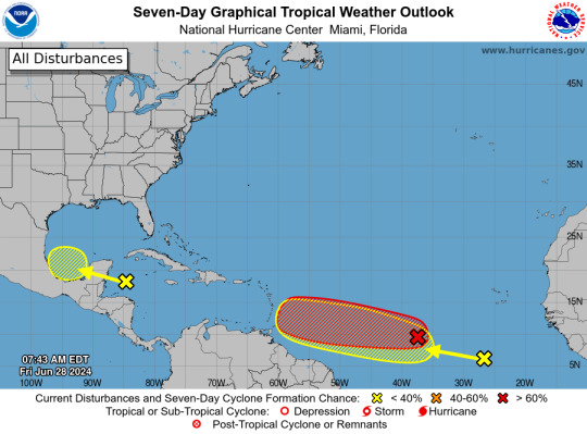
Western Caribbean/Southwestern Gulf of Mexico (AL94): A broad area of low pressure over the western Caribbean Sea associated with a tropical wave continues to produce widespread shower and thunderstorm activity. Development of this system is not expected today while it moves west-northwestward at around 15 mph, and an Air Force reconnaissance mission planned for today has been canceled. The disturbance is then expected to move westward over the Yucatan Peninsula and emerge over the Bay of Campeche late Saturday or early Sunday, at which point some development will be possible. Regardless of development, heavy rainfall associated with the tropical wave will affect portions of Central America and Mexico through the weekend.
* Formation chance through 48 hours...low...30 percent.
* Formation chance through 7 days...low...30 percent.
Central Tropical Atlantic (AL95): A low pressure system located about 1500 miles east-southeast of the Windward Islands is gradually becoming better defined. Showers and thunderstorms are also showing signs of organization, and a tropical depression or tropical storm will likely form later today or on Saturday. This system is expected to move westward at 15 to 20 mph and approach the Lesser Antilles by the end of the weekend. Interests there should monitor the progress of this system. For more information, including gale warnings, see High Seas Forecasts issued by the National Weather Service.
* Formation chance through 48 hours...high...90 percent.
* Formation chance through 7 days...high...90 percent.
Eastern Tropical Atlantic: A tropical wave centered several hundred miles south-southwest of the Cabo Verde Islands is producing disorganized showers and thunderstorms. Some slow development of this system is possible next week while it moves generally westward across the central and western tropical Atlantic at 15 to 20 mph.
* Formation chance through 48 hours...low...near 0 percent.
* Formation chance through 7 days...low...20 percent.
&& High Seas Forecasts issued by the National Weather Service can be found under AWIPS header NFDHSFAT1, WMO header FZNT01 KWBC, and online at ocean.weather.gov/shtml/NFDHSFAT1.php
$$ Forecaster Cangialosi/Zelinsky
#bot post#meteorology#weather#tropical weather#tropical storm#tropical depression#hurricane#atlantic#atlantic ocean#caribbean#gulf of mexico#noaa#national oceanic and atmospheric administration#nhc#national hurricane center
6 notes
·
View notes
Text
Water in Costa Rica: A Vital Resource for Sustainability
Water in Costa Rica is one of the country's most precious natural resources, playing a vital role in its biodiversity, agriculture, and everyday life. As a country known for its lush rainforests and abundant rivers, Costa Rica is home to an intricate network of freshwater systems. However, managing and protecting these water resources is critical for the nation’s long-term sustainability, especially in the face of climate change, population growth, and increasing demand for clean water.

At Pura Vida Drilling, we understand the importance of ensuring a sustainable water supply in Costa Rica. From groundwater exploration to well drilling and maintenance, our services are designed to provide safe and reliable access to clean water across the country.
Water Availability in Costa Rica
Costa Rica is blessed with significant water resources, receiving ample rainfall throughout most of the year. The country has 34 river basins, countless lakes, and vast underground aquifers that provide water for both personal and commercial use. While the country's Pacific side tends to have drier regions, the Caribbean and central highlands are rich in water in Costa Rica, thanks to frequent rains and an extensive watershed.
Despite this abundance, Costa Rica faces challenges in managing its water supplies. Urbanization, agricultural expansion, and tourism growth have led to increased demand for water in Costa Rica, especially in drier regions like Guanacaste. Additionally, climate change has caused unpredictable weather patterns, making it harder to ensure consistent water availability in certain areas.
Groundwater: A Critical Resource
One of the most reliable sources of water in Costa Rica is its groundwater, which is essential for communities, agriculture, and industrial projects. Groundwater is found in aquifers—natural underground reservoirs—throughout the country. These aquifers are tapped for various uses, including drinking water, irrigation, and commercial operations. However, the extraction of groundwater must be managed carefully to prevent over-exploitation and contamination.
At Pura Vida Drilling, we specialize in groundwater exploration and well drilling to ensure that water in Costa Rica is accessed safely and sustainably. Our team of experts uses advanced techniques to identify the best locations for wells, taking into consideration the local geology, hydrology, and water demand. This approach helps protect the long-term health of aquifers while providing reliable access to clean water.
Water Well Drilling and Maintenance in Costa Rica
As demand for water grows, particularly in regions experiencing seasonal droughts, water wells have become a crucial solution for providing a steady supply. Pura Vida Drilling offers professional water well drilling services for residential, agricultural, and commercial projects throughout Costa Rica. Whether you're looking to secure water for your home, farm, or business, we provide customized drilling solutions that meet your needs while ensuring environmental responsibility.
Our well services include:
Site Evaluation: We conduct comprehensive studies of your property to determine the optimal location for well drilling, taking into account the depth of aquifers and water quality.
Well Installation: Using the latest technology, we drill wells that are built to last, ensuring efficient and safe access to groundwater.
Well Maintenance: Regular well maintenance is essential to keep your water system functioning properly. We offer inspection, cleaning, and repair services to ensure your well delivers clean water for years to come.
Pump Repair and Replacement: If your well pump is malfunctioning, our team can quickly diagnose and repair the issue to minimize disruption to your water supply.
Permits and Regulations for Water Use
Accessing water in Costa Rica, especially through groundwater wells, requires adherence to strict regulatory frameworks. The AyA (Instituto Costarricense de Acueductos y Alcantarillados) is the government body responsible for overseeing water resources, including issuing permits for well drilling and groundwater extraction.
At Pura Vida Drilling, we help clients navigate the complex process of securing permits and concessions for water wells in Costa Rica. Our experience ensures that all legal requirements are met, so you can have peace of mind knowing that your project complies with local laws. From initial paperwork to final approval, we are with you every step of the way.
Sustainable Water Solutions for the Future
As Costa Rica continues to grow and evolve, responsible water management will be key to the country’s prosperity. At Pura Vida Drilling, we are committed to promoting sustainable practices that protect water resources for future generations. Our team not only provides access to groundwater but also advises on best practices for conserving and using water efficiently.
Whether you need a new water well, maintenance for an existing system, or expert consultation on groundwater resources, Pura Vida Drilling is your trusted partner in securing safe, reliable water in Costa Rica.
Contact Us
For more information about our water well drilling services and groundwater exploration, contact Pura Vida Drilling today. We are dedicated to helping you access the water you need while preserving Costa Rica’s natural beauty and resources for the future.
0 notes
Text
Tropical Storm Helene prompts evacuations in Florida
Florida residents are already evacuating and filling sandbags days ahead of the arrival of Tropical Storm Helene, which is forecast to rapidly intensify into a hurricane.
Helene formed Tuesday in the Caribbean Sea, is expected to cross the Gulf of Mexico and make landfall as soon as late Thursday. Hurricane watches have been issued for parts of Cuba, Mexico and part of the Florida coastline, including Tampa Bay. A tropical storm warning has been issued for parts of the Florida Keys.
Official projections from the National Hurricane Center call for Helene to become a devastating Category 3 hurricane with peak sustained winds of 115 mph at landfall.
On Tuesday, Florida Gov. Ron DeSantis expanded a state of emergency declaration to 61 counties. The state also issued voluntary and mandatory evacuation orders in 13 counties.
Federal authorities are positioning generators, food and water, along with search-and-rescue and power restoration teams, as President Joe Biden also declared an emergency in Florida.
The storm is anticipated to be unusually large and fast-moving, meaning storm surge, wind and rain will likely extend far from the storm’s center, the hurricane center said. Georgia Gov. Brian Kemp has declared a state of emergency. And states as far inland as Tennessee, Kentucky and Indiana could see rainfall.
Hal Summers, a restaurant worker in Mexico Beach, Florida, needed no reminding after he barely survived Hurricane Michael in 2018. DeSantis has said Helene is reminiscent of that Category 5 hurricane, which rapidly intensified and caught residents off guard before plowing a destructive path across the western Florida Panhandle.
When it hit, Summers waded with his cat in his arms as waters began rising rapidly in his parents’ house. Their house and his home were destroyed.
“That was such a traumatic experience that that is not the place I needed to be for myself,” he said Tuesday as he evacuated with a friend to Marianna, a town farther inland.
Many areas are forecast to see dangerous storm surges, especially between Panama City and Tampa. The coast stretching from Ochlockonee River to Chassahowitzka could see between 10 and 15 feet of water. Nearby areas could see between 5 and 10 feet of water, and the Tampa Bay area is forecast to experience between 5 and 8 feet of storm surge.
The Florida Keys may see between 1 and 3 feet of storm surge.
The Florida Division of Emergency Management’s Know Your Zone map allows residents to input their address and learn their evacuation route in case of flooding or other disaster.
More from CBS News
Source link
via
The Novum Times
0 notes
Text
Hurricane Helene 2024: Will Florida Survive This Deadly Storm

Tropical Storm Helene is strengthening rapidly and will possibly become a major hurricane in the Gulf of Mexico in the near future. Projections suggest Hurricane Helene will reach the landfall later this week, causing potentially lethal impacts to Florida and the Northern Gulf Coast. It is suggested that the people be ready for potentially harmful storm surges, intense rain, and powerful winds.
Helene's Track and Intensity
According to the National Hurricane Center (NHC), Tropical Storm Helene is coming in west of Jamaica in the Western Caribbean Sea, and it is likely that it will transform into Hurricane Helene by Wednesday. Current models are projecting that she will make landfall along Big Bend or Panhandle in Florida by Thursday, yet further clarification on the track still poses uncertainty.
The entire Gulf Coast is on alert because many spaghetti models indicate that the storm could affect areas from Florida to Louisiana.
Storm Surge and Heavy Rain: Effects of Storm Threat Impacts
The primary threats from Hurricane Helene include storm surge, heavy rainfall, and flash flooding. Areas from Florida's Gulf Coast should begin experiencing effects by Wednesday, as reported by the Florida hurricane tracker. According to the Florida hurricane tracker, the Keys, Tampa, and Orlando are expected as well to see major amounts of rain and wind.
In specific regions, storms resulting in more than 12 inches of rain may cause floods. Flooding may become a problem as the storm moves inland, affecting not just the Gulf Coast but also the interior regions of Georgia, Alabama, and other Southeastern states.

Hurricane Helene 2024 Florida and Gulf Coast Prepare for Impact
Gulf Waters' Warmth Is Driving Hurricane Helene's Growth
Warm waters in the Gulf of Mexico, near a record high, are actually one of the main reasons why Hurricane Helene is likely to be a powerful hurricane. This warm water will probably help Hurricane Helene become at least a Category 3 hurricane. The NHC advises those in the Gulf Coast region to pay attention and prepare. Preparing for Hurricane Helene.
Expect evacuations in Florida and along the Gulf Coast as storm surges are anticipated to strike in these locations; prepare with emergency kits and secure your property before these evacuations become necessary due to further orders. Check the NOAA Hurricane Tracker and other weather services for current conditions.
For those interested, the following sources also have further advice on safe travel and preparation for every kind of weather. If you plan to travel during or after the storm, you may also want to read up on the best time to visit Antigua.
.
Conclusion: Stay Safe and Informed
As Hurricane Helene approaches,Residents of Florida and any other state along the Gulf Coast have no reason at all to take this storm lightly, especially because it may make landfall on Thursday and is as likely to be a Category 3 hurricane. There's no time to put things off. One needs to be safe, informed, and act. (Source: The Weather Channel )
Read the full article
0 notes
Last Seen Blogs

slav-rar
🍥🍥

doctodad
Good Question, Next Question

dppaintingvictorville
Untitled

strapsleeve
:flushed:

doublecupbaby-blog
$¢r3w