#Eagle Rock Topanga State Park California
Text

Captivating Views: Experience the Hollywood Sign at Sunset Ranch in California
Immerse yourself in the allure of Sunset Ranch, the ultimate destination to experience captivating views of the iconic Hollywood Sign in California. Embark on a scenic horseback ride through the picturesque trails, accompanied by knowledgeable guides who provide fascinating insights into the history and significance of the sign. Capture breathtaking moments and create lasting memories as you witness the Hollywood sign from Sunset Ranch California.
Visit: https://www.hikeforfunandfitness.com/hollywood-sign-hike-from-sunset-ran
#Hollywood sign from Sunset Ranch California#death valley artist palette#Eagle Rock Topanga State Park California#Paseo Miramar Trail California
0 notes
Text
Originally hiked: 6/2/2019
This past weekend I went on a solo hike in our backyard mountains to Eagle Rock. Haven’t been hiking The last time I went hiking was Baden-Powell about a month ago which I haven’t written a blog yet, but I did put together a youtube vlog of the hike. Check it out if you have a second. There are several ways to visit Eagle Rock in the Santa Monica Mountains. If you are looking to do a close by hike if you live in the area, this is a good training hike. The easier route is actually from Trippet Ranch ($10 parking or park outside the park for a longer hike).
What’s in this Guide?
Hike Stats – Mileage, elevation gain, map of hike, weather
Directions – quick write-up on how to get to the trailhead
What to Pack – some gear, map and food recommendations
Blabbering – best part of the write up, my pictures and thoughts of the hike
1. Hike Stats
Location Mileage Elevation Gain Type Santa Monica Mountains 7.24 mi 1556 feet Out-and-back
map of hike
weather
Topanga – Weather Forecast
I ended up taking a rain jacket because the forecast stated that there was a chance of light rain. I didn’t end up using it at all, but better to be safe then sorry.
2. Directions
To get to the trailhead –
From I-10 W, continue onto CA-1 N (Pacific Coast Highway), turn right onto Sunset Blvd. about 4.4 miles from I-10 W. Drive 0.4 miles and turn left onto Palisades Dr. Continue on Palisades Dr. for 2.5 miles until you hit Vereda De La Montura, turn left. The trailhead is on the right, there is a sign that notates “Santa Ynez Canyon Trail”. There is parking on the street, but not overnight – make sure you read the signs before you go.
3. What to Pack?
Since I did a day hike and it was very local, I packed minimally. Here are some of the items that I took on this hike:
Backpack: Osprey Hydration Pack
Hiking Poles: REI Co-op Carbon Trekking Poles
Hydration Reservoir: Osprey Hydraulics Reservoir 2.5 L
First Aid Kit: Adventure Medical Kits Ultralight
Headlamp: Black Diamond Storm Headlamp
Hiking Shoes: KEEN Targhee II Mid Waterproof Hiking Boot
Satellite Messenger: Garmin inReach Exporer+
GPS Watch: Garmin Fenix 5X Plus+
Rain Jacket
Toilet paper/ziplock
Knife
Food
To-Go Wrap: Recipe
Mozarella cheese stick
Starkist Salmon Creations Lemon Pepper & Mayonnaise
amzn_assoc_placement = "adunit0"; amzn_assoc_search_bar = "true"; amzn_assoc_tracking_id = "beyondlimit09-20"; amzn_assoc_ad_mode = "manual"; amzn_assoc_ad_type = "smart"; amzn_assoc_marketplace = "amazon"; amzn_assoc_region = "US"; amzn_assoc_title = "My Amazon Picks"; amzn_assoc_linkid = "6bf03b677b5a7885eb2b750b80be56e4"; amzn_assoc_asins = "B01MY03CZP,B07DVK7RPX,B00GZPZ03Q,B000G80KZQ,B06WVK7LZS,B017ONQM5W,B014EC8862,B01N817479";
amzn_assoc_placement = "adunit0"; amzn_assoc_search_bar = "true"; amzn_assoc_tracking_id = "beyondlimit03-20"; amzn_assoc_ad_mode = "manual"; amzn_assoc_ad_type = "smart"; amzn_assoc_marketplace = "amazon"; amzn_assoc_region = "US"; amzn_assoc_title = "Some great hiking gear"; amzn_assoc_linkid = "5d82e2df33165217cefac200495e2ce3"; amzn_assoc_asins = "B01MY03CZP,B07D9B9DJM,B00GZPYWFS,B000G80KZQ,B06WVK7LZS,B017ONQM5W,B07GHKHQGM,B01N817479";
Check out a little more gear I have currently on my What’s in My Backpack Page& some Backpacking Gear Ideas.
4. My Blabbering
Before I get into blabbering a little more about this hike, why don’t you take a look at the YouTube video I put together for this hike.
youtube
I had been sick all week and was itching to get outdoors and decided that it was going to be for a hike not too far away from home. I’ve done part of this trail before and thought it would be cool if there would be water in the creek and wanted to check it out.
The start of a local hike
I was the second car parked for the trailhead, which is awesome and that’s why I got there just after 6:30am. As I finished off my coffee from Starbucks, I turned on the Garmin inReach because there was no service in the area. Once I got it working, I sent a message to a couple people that I was beginning my hike. When I send the message it sends the location I sent it from as well; one of the reasons having a satellite communicator is something I recommend anyone who goes outdoors and is out of cell phone range.
When you begin the trail there is a little pavement that later disappears into a single track dirt trail. The first portion of the trail is all flat and goes alongside the creek. I had to cross the creek several times, but to my knowledge there hasn’t been so much water that you would get wet.
I passed a sign that says “Waterfall” about 0.6 miles. The trail eventually ascends up the side of the canyon and out into the open around 1.5 miles.
For the first 2.8 miles of the hike I did not see one soul. And the thing about being the first person on the trail especially at this time of year is that you will hit a ton of spider webs. For this reason, my hiking poles became my best friend on this hike.
At about 2 miles you will hit the Eagle Rock Canyon Fire Rd. Not quite a trail, but still a great place to get a 360 degree view of the surrounding area. This portion of the trail seems to be flat at first, but to reach Eagle Rock there is still about 700 feet elevation gain, however it’s very gradual. At this point, I saw way too many people for my liking on a hike, but what can I expect when I’m in Los Angeles area.
I stood on Eagle Rock at a good time because I was the only one who ended up going to it. There were several other people around with just different destinations. The rock itself is made of sandstone, if you climb onto it, you can get quite a view of the area.
A little background
The original name of Eagle Rock was “Elephant Rock”, mainly because the way it looks to the human eye is like an elephant head when standing on the north side.
I bet if it was a clearer day I would have had some ocean views. I quickly ate a little of my To-Go Wrap before I headed back down before even more crowds would show up.
On my way down
On my way out once I got back onto Santa Ynez Canyon Trail, I had a good mile or so that I didn’t see anyone on the trail. I hadn’t hiked this long in a while, so my legs were definitely getting tired once I hit the 6 mile mark. I finally ran into a couple families along the way just near the trailhead. There was a group of teenagers who were hiking in and the last of them had a stick he was holding and asked me if I wanted to switch. At first I didn’t get it, but it was a joke to switch my poles with his stick. I said “good one”. Thought it was a funny little story to share with you all.
All in all great hike to go on if you’re just trying to get a quick morning hike or afternoon hike in.
Happy Adventures,
Annette, Adventurer – Beyond Limits on Foot
Related links
Before I go on a hike I always check some other peoples write-ups. Here are some others you may want to check out to read further:
Hikespeak – Eagle Rock from Trippet Ranch in Topanga State Park
Hiking Project – Eagle Rock Loop
SoCalHiker – Eagle Rock in Topanga State Park
Modern Hiker – Eagle Rock and Temescal Peak
Well I hope you loved reading along. If you want to check out more on the hike, don’t forget to check my YouTube channel here: Beyond Limits on Foot YouTube Channel.
Follow me on Instagram
[maxbutton id=”10″ url=”https://instagram.com/beyondlimitsonfoot”%5D
[ap_instagram_mosaic_lightview]
Eagle Rock via Santa Ynez Canyon Trail - Santa Monica Mountains Originally hiked: 6/2/2019 This past weekend I went on a solo hike in our backyard mountains to Eagle Rock.
#California#eagle rock#Hike#hiking#Outdoors#pacific palisades#santa monica mountains#Southern California#topanga state park#Trail
1 note
·
View note
Photo


Eagle Rock, Topanga State Park, CA
#eagle rock#topanga#california#state park#about me#i don't have a fancy camera just my phone but#there ya go#i hiked up here with my family and my aunt/uncle/cousin who we are visiting in ca
4 notes
·
View notes
Photo

You’re ALL fine, unless you were inspired by this quote to take a picture of a unicorn in the kitchen....than be concerned. #unicorn #sanity #kitchen #comedy #instafun #naturephotography #photooftheday #hilarious #losangeles #california #summer #itsalwayssummer #tan #tanaf #love (at Topanga State Park: Eagle Rock Loop Trail) https://www.instagram.com/p/B1OeheKnbp1/?igshid=iw18q9mol5d0
#unicorn#sanity#kitchen#comedy#instafun#naturephotography#photooftheday#hilarious#losangeles#california#summer#itsalwayssummer#tan#tanaf#love
0 notes
Photo

Fun times while Jason's brother Keegan has been in town! Went to Santa Monica Pier, saw a seal, went to El Matador State Beach, and climbed to the top of Eagle Rock in Topanga State Park. I've been still working while doing all this so my body is tired, but my soul has felt restored with all this nature exposure. I'm loving the California life, and can't imagine ever moving back to Missouri. #California #CaliGirl #Spoonie #ElMatador #topangacanyon #beach #nature #EagleRock #family #jason (at Los Angeles, California) https://www.instagram.com/p/Bx9EzsoAYJj/?igshid=1qrlgsr2ylmsa
0 notes
Photo

#losangeles on top of the other Eagle Rock, the one in #topangastatepark ▫▫▫▫▫california #hitthetrails #instahike #hiking #hikingadventures #hikinginla #hikesocal #hikela #vscocam C6 #vsco📷 #vsco #overcast #overcastinla #sceneryshots #views #instaview #stateparks #ilovela #beerbandsandscenery 11/12/#2017 #eaglerocktopanga #eaglerock #eaglerocktop (at Topanga State Park)
#overcast#views#ilovela#hikingadventures#stateparks#vsco📷#topangastatepark#overcastinla#hiking#vscocam#sceneryshots#2017#eaglerocktopanga#instaview#vsco#hikesocal#beerbandsandscenery#instahike#losangeles#hikinginla#eaglerocktop#eaglerock#hitthetrails#hikela
0 notes
Text
Tranquil Trails: Your Guide to Topanga State Park's Natural Wonders
Tucked away in the rugged hills of Southern California, Topanga State Park stands as a serene oasis amidst the urban hustle and bustle. This enchanting park, with its diverse ecosystems and scenic beauty, has rightly earned its reputation as a natural wonderland. Join us on a journey through the tranquil trails of Topanga State Park California, where nature's wonders unfold at every turn.
A Wilderness Retreat in the City
Located just a stone's throw from Los Angeles, Topanga State Park offers a unique blend of wilderness and accessibility. As you step onto its well-maintained trails, the city's noise and chaos seem to fade away, replaced by the soothing sounds of chirping birds and rustling leaves. It's a testament to the park's role as a haven for urban dwellers seeking solace in nature.
Scenic Hiking Adventures
Topanga State Park boasts an extensive network of hiking trails, each offering a unique experience. From the panoramic vistas of Eagle Rock to the shaded tranquility of the Musch Trail, there's a hike for every preference and skill level. The park's trails are perfect for both seasoned hikers and families looking for a leisurely stroll.
Biodiversity in Abundance
Nature enthusiasts will revel in the park's remarkable biodiversity. Topanga State Park is home to a variety of plant and animal species, including the iconic California live oak, sycamore, and the elusive bobcat. Birdwatchers can spot everything from red-tailed hawks to colorful songbirds.
Seasonal Delights
The park's character evolves with the seasons. Spring brings a burst of wildflowers, painting the landscape in vibrant colors. Summer offers sunny days and cool canyons for respite. Autumn sets the trees ablaze with fiery foliage, and winter brings crisp air and the possibility of spotting seasonal waterfalls after a rain.
Plan Your Visit
Before embarking on your Topanga adventure, remember to check for trail conditions and any park alerts. It's crucial to stay hydrated, wear appropriate attire, and follow Leave No Trace principles to preserve the park's natural beauty.
As you explore the tranquil trails of Topanga State Park, you'll not only find solace in nature but also discover the profound beauty of this Southern California gem. So, lace up your hiking boots, breathe in the fresh air, and let the wonders of Topanga State Park captivate your soul.
0 notes
Text
Best Hiking Trails Near Hummingbird Trail
Hummingbird Trail is an iconic hiking trail located within Topanga State Park. It is known for its rich foliage, local wildlife, and stunning vistas. The trail is relatively easy, only lasting about an hour and a half roundtrip. It is a great option for beginners or those looking for a short hike with impressive views.
Hummingbird Trail is one of the most popular trails in Topanga State Park. Located in the heart of the park, it is a great place to enjoy nature and take in the stunning views. The trail is also a great way to explore the surrounding area and to catch glimpses of some of the wildlife that inhabits the park. One of the best hikes near Hummingbird Trail is to explore Temescal Ridge.
Topanga State Park California is an iconic park that is located in the Santa Monica mountain range. It spans 11,000 acres of land and is the largest wildland within the city of Los Angeles. There are over 36 miles of trails that wind through the park, making it a popular destination for hikers, bikers and equestrians. The park also contains important wildlife habitats for animals like deer, bobcats, and a variety of birds.
One of the most popular hiking trails near the Hummingbird Trail is the Eagle Rock Trail. This trail is two miles long and meanders through the park, providing stunning views of the surrounding mountains and valleys. The trail has several difficult stretches, making it a favorite for serious hikers. Also nearby is the Backbone Trail, which is an eight mile long trail that runs through Topanga State Park and offers plenty of challenging terrain.
One of the best hikes in Topanga State Park is near the Hummingbird Trail. It is an easy to moderate trail that is great for families. It is a 4.6-mile loop that has a great mix of terrain, including rolling hills and open meadows. Along the trail, hikers can catch glimpses of the ocean as well as beautiful wildflowers, native plants and bird species.
For more details you can visit :- www.hikeforfunandfitness.com/
#Topanga State Park California#Death Valley National Park in California#humming bird#Topanga State Park#hiking#california
0 notes
Photo
Looking for A guide for Topanga State Park California ?
Topanga State Park California is a state park in United States, on the Pacific Coast. It is located in southwestern Los Angeles County, southern California. The park is located approximately 20 mi (32.2 km) northwest of Santa Monica, and is famous for its stunning canyons, rolling chaparral-covered hills, and panoramic coastal views. They provide pleasant hiking, biking and horseback riding.
#san bernardino peak trail#death valley artist palette#artists palette death valley California#parker mesa overlook#Paseo Miramar Trail California#San Bernardino Peak Trail 1w07#Death Valley National Park in California#Hummingbird Trail#Topanga State Park California#Eagle Rock Topanga State Park California#Sequoia National Park California#Baldwin Hills Scenic Overlook California#Hollywood sign from Sunset Ranch California
0 notes
Link
Parker Mesa Overlook via Paseo Miramar Trail, is on the boundaries of the Mojave Desert, is a favourite spot for family picnics and school field trips. Hike for Fun and Fitness is an instructional website that helps to find useful information about hiking for everyone. It contains step by step Parker Mesa Overlook picture gallery.
#Hollywood sign from Sunset Ranch California#Parker Mesa Overlook via Paseo Miramar Trail#Baldwin Hills Scenic Overlook California#Sequoia National Park California#Eagle Rock Topanga State Park California#Topanga State Park California#Hummingbird Trail#Death Valley National Park in California#San Bernardino Peak Trail 1w07#Paseo Miramar Trail California#parker mesa overlook#artists palette death valley California#death valley artist palette#san bernardino peak trail#Parker Mesa Overlook California
0 notes
Link
#Parker Mesa Overlook via Paseo Miramar Trail#Hollywood sign from Sunset Ranch California#artists palette death valley California#Paseo Miramar Trail California#death valley artist palette#Eagle Rock Topanga State Park California#Hummingbird Trail#San Bernardino Peak Trail 1w07#san bernardino peak trail#Topanga State Park California
0 notes
Audio
Travel Tips for Parker Mesa Overlook via Paseo Miramar Trail in California
Parker Mesa Overlook via Paseo Miramar Trail, is on the boundaries of the Mojave Desert, is a favourite spot for family picnics and school field trips.
#Parker Mesa Overlook via Paseo Miramar Trail#Hollywood sign from Sunset Ranch California#Baldwin Hills Scenic Overlook California#Sequoia National Park California#Eagle Rock Topanga State Park California#Topanga State Park California#Hummingbird Trail
0 notes
Video
undefined
tumblr
Hiking Tips For Paseo Miramar Trail in California By Hike For Fun And Fitness.
Hiking Tips for the Paseo Miramar Trail in California. This is a great trail with amazing views of the Pacific Ocean. It is a 3.2 mile hike and there are some hills to climb so make sure you are prepared for that .Hike the Paseo Miramar Trail to the beach in Malibu, California. This three-mile one-way hike offers stunning views of the Pacific Ocean and is great for all levels of hikers.
#Parker Mesa Overlook California#san bernardino peak trail#death valley artist palette#artists palette death valley California#parker mesa overlook#Paseo Miramar Trail California#San Bernardino Peak Trail 1w07#Death Valley National Park in California#Hummingbird Trail#Topanga State Park California#Eagle Rock Topanga State Park California#Sequoia National Park California
0 notes
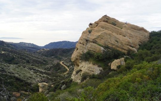
Photo

Eagle Rock Topanga State Park - A Great Southern California Park
Eagle Rock Topanga State Park is a 63-acre park with a wide variety of terrain. There are steep canyons, oak, sycamore and chaparral covered hillsides, grassy valleys and rugged rock formations.
#Eagle Rock Topanga State Park California#Sequoia National Park California#Baldwin Hills Scenic Overlook California
1 note
·
View note
Link
#Parker Mesa Overlook California#san bernardino peak trail#Sequoia National Park California#Eagle Rock Topanga State Park California#Topanga State Park California#Hummingbird Trail#Death Valley National Park in California#Paseo Miramar Trail California
0 notes
Video
undefined
tumblr
Visit Topanga State Park And Death Valley National Park in California With Our Assistance.
Revel in the majestic beauty of California's deserts, with two of the most popular parks - Death Valley National Park and Topanga State Park - just a few hours from Los Angeles. Extend your visit to the coast, or head north to San Francisco.
#Topanga State Park California#Eagle Rock Topanga State Park California#Death Valley National Park in California#Hummingbird Trail#Sequoia National Park California
0 notes
Last Seen Blogs

novus-noctis
I am the cinnamon peeler

errorbrayd3n
Brayden's Random Thoughts

daisyoconnorwaterville-blog
DaisyOco

nyannta
にゃんた

jisookdays
daydreamer