#GIS Survey and data processing
Explore tagged Tumblr posts
Visit Tumblr Blog
Explore Tumblr blogs with no restrictions, modern design and the best experience.
Last Seen Tumblr Blogs


Fun Fact
Tumblr was attacked by a cross-site scripting worm deployed by the Internet troll group GNAA on Dec 3, 2012.
Text
Why Is GIS Surveying in High Demand in the UAE? Unlocking Accurate Data for Smarter Decisions
In the middle of the Arabian Peninsula, the United Arab Emirates shows off what people can accomplish through their ideas and the use of new technology. Among all the digital changes happening in this country, GIS surveys and data processing have become important tools for building roads and homes, planning cities, and taking care of the environment. Embracing GIS shows that the UAE values using data for decisions, helping the country progress sustainably in a world where things are getting more intricate.

The Evolution of GIS in the UAE started as a way to track and map important data for cities, and now it is used for almost all types of activities and services in the country.
The technology started as simple ways to map areas and has grown into tools that examine how different areas relate to each other across the country. The government of the UAE saw from the start that effective handling of spatial data would be key for achieving its big development plans. Today, GIS is used in many parts of life in the UAE, like helping people build things, plan roads, find doctors, and attract tourists.
Applications Transforming the Nation
The footprint of GIS survey and data processing covers different fields in the UAE. They make it possible for those working in urban planning to visualize, assess, and improve city designs before starting construction. GIS technology was used to design the Palm Jumeirah island in Dubai to provide strong structures and ensure that it does not harm the environment.
Scientists in the field use GIS to look out for changes in the shape of dunes and to locate places that might turn into deserts. By having this data, officials can work more effectively to manage and protect water resources where there is a long-standing problem with not having enough water.
Advanced-Data Collection Methods
The accuracy of GIS applications is mostly determined by how good the data are that people gather. Data collection in the UAE uses important methods such as LiDAR, imaging via drones, and imagery from satellites to ensure the highest level of accuracy. With mobile GIS, teams can catch data live and prevent mistakes made by humans.
showing how committed they are to data, the city’s Smart Geospatial Contact Center uses AI to check and correct geographical information used in different systems. The focus on data accuracy has made the UAE a leader in geospatial intelligence in the region.
Digital Transformation and Integration
It is not just the use of GIS that makes the UAE unique, but also how they connect GIS with different digital tools. By using GIS data, the country’s efforts to become a smart city create well-connected urban areas where different complimentary systems and services are together.
The Roads and Transport Authority in Dubai uses GIS to improve traffic management, cut down on congestion, and set up future transportation systems. As another example, telecom companies use precision mapping so that underground operations during maintenance and construction are less likely to disrupt visitors or everyday usage.

Overcoming Challenges Through Innovation
Certain problems arise when GIS surveys and data processing are used in the UAE. Difficult desert conditions influence the tasks conducted by oilfield workers and the performance of equipment. Fast growth in cities means that spatial databases must be updated often to remain precise.
As a result, people have devised new ways to tackle these issues. Companies in the UAE have both designed heat-resistant tools and developed new techniques for surveying deserts. Initiatives from the government, including the UAE Spatial Data Infrastructure, have helped to ensure standards for data sharing and compatibility, making the whole national spatial data system more unified.
Building Local Expertise
Understanding that the impact of technology depends on learning, the UAE has focused on developing GIS experts within the country. Colleges and universities offer courses in geospatial sciences, and there are professional certification courses available for already-employed individuals. As a result, the knowledge is shared and helps build lasting resources within the Emirates.
The Road Ahead
When we think about the future, GIS survey and data processing in the UAE will include emerging technologies such as artificial intelligence and blockchain to make both data analysis and security better. They will help the country achieve vital objectives, like ensuring enough food and adapting to climate change.
By embracing GIS in the UAE, the country has demonstrated that using spatial intelligence can help strengthen, organize, and sustain a society. With the help of GIS, Emirati agencies can now study and survey the regions of Abu Dhabi and Dubai, while mapping how the economy moves toward knowledge-work.
Accurate Survey UAE provides precise land, building, and construction surveys using advanced technology, ensuring reliable results for projects across the UAE. If you would like to learn more about GIS survey and data processing, you can visit the page.
0 notes
Text
The Ever-Changing Length of the PCT
The most recent edition of the PCT's "Trail Dirt" tackled the mystery of the PCT length . . . it has been a topic that has been a curiosity also explored on this website -- https://pcttrailsidereader.com/post/618834872879939586/it-looks-authoritative-and-permanent-but-the The midpoint looks so official but as this article explains, the length of the trail is constantly changing . . . hence moving the midpoint. However, the marker stays put.
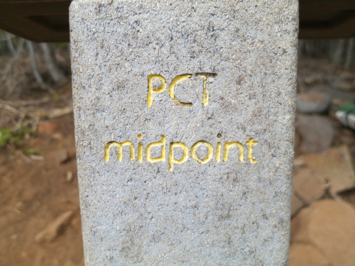
Easy, 2,650 Miles, right? Well… not quite.
By Galen Keily
The question of the PCT’s length comes up often, with guidebooks, phone apps, and other sources across the internet offering varying figures. In recent years, PCTA has come a long way in better tracking and calculating distance. While we regularly reference the rounded figure of 2,650 miles as shorthand for the trail’s length, our current best estimate places it at approximately 2655.8 miles. It’s complicated because the length actually varies year by year, and homing in on highly accurate mileage for a trail that spans thousands of miles can pose significant challenges. We know that trail mileage matters a lot to PCT trail users. Read on to discover some of the complexities involved in determining the true length of the PCT.

Northern Terminus, Photo by: Ryan Weidert
It Moves!
Sometimes, the trail gains a mile or two, or sometimes, the trail shaves off miles (you’re welcome thru-hikers!) You might be thinking… how does this happen, isn’t the trail already on the ground? While true, PCTA, alongside managing agencies and dedicated trail crews, continually refines and optimizes the trail’s route. These efforts range from minor adjustments to larger-scale relocation projects aimed at enhancing the overall trail experience. For instance, routine maintenance often involves realigning sections of the trail to improve sustainability, such as adding switchbacks or adjusting trail tread within the existing corridor. These alterations might end up making the trail a bit longer or shorter, typically on the order of hundreds of feet. Pretty small potatoes when looking at a trail that crosses thousands of miles. Other times, the PCT undergoes bigger relocation projects based on a process called Optimal Location Reviews (OLR). These relocations can be significant and can take years to complete. These projects aim to relocate the PCT to a location better suited to providing a natural setting, scenic beauty, and safe public access, among other things. As a result of these projects, the trail’s length may fluctuate by several miles. But they also end up making the trail safer and more enjoyable for all.
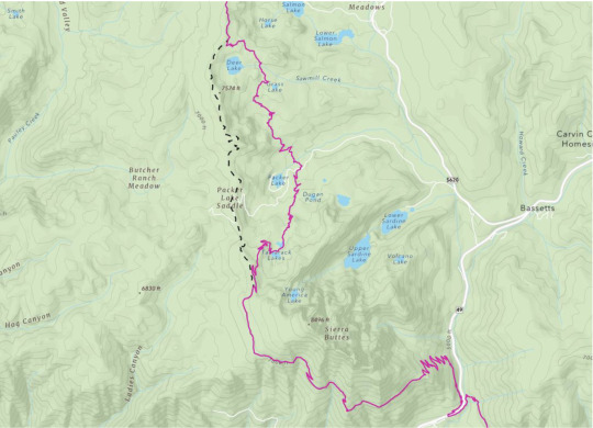
The Sierra Buttes Relocation – Old decommissioned PCT shown in dashed black line, current PCT in maroon.
What’s so hard about miles?
Calculating distance across such a large geographic extent is challenging. Even minor inaccuracies that are repeated hundreds of thousands of times compound errors, resulting in significant discrepancies in overall mileage. For example, if each point in our PCT dataset were off by 1ft, the margin of error would be over 200 miles. Additionally, the translation from a three-dimensional Earth to a two-dimensional map necessitates “projecting” data in GIS (Graphical Informational System) software, which can introduce different types of accuracy loss. However, advancements in technology offer us promising avenues for improvement, such as using LiDAR (laser scans of the earth) to more precisely capture and map changes to the trail.
A little bit about the data
PCTA’s current iteration of PCT mapping data is built upon data that was donated to the organization from the Halfmile Project. You may have heard of Halfmile, he and his team are kind of a big deal. The resulting data from this project’s multi-year effort was the best, most accurate data for the PCT of its time. Volunteers in the project mapped thousands of miles of trail with survey-grade custom and commercial GPS units and spent tremendous amounts of time analyzing, processing, and curating the results.

Halfmile, using his iPhone to control the Long Distance Geo Logger. The blue GPS unit is in the lower black side pocket of his pack. You can see coiled cable right above it.
Building on this legacy, PCTA now builds upon that same highly accurate data from Halfmile, revised to account for re-routes and trail reconstruction that have happened since PCTA assumed control of the data. We maintain our PCT Centerline (the line data for the trail’s location) and Mile Markers (points every tenth or half mile), with new versions released on an annual basis, usually in January. The data is displayed on our Interactive Map and made available on our PCT Data webpage, freely available for download in a variety of formats. By fostering an environment of transparency and accessibility, we empower trail users, app developers, and agency partners alike to utilize this standardized dataset, facilitating seamless communication and navigation along the trail.

Graceland takes an emotional moment at the Northern Terminus after an adventure of a lifetime. Photo by: James Townsend
Conclusions
As we continue to monitor changes, refine our modeling of the PCT, and offer it to users in new ways, we realize that our data remains imperfect. Digitally representing the complexities of the natural world always is. Despite this, the Association’s renewed prioritization of data management, built upon the invaluable foundation set by the Halfmile project, marks significant progress in this work. We recognize that our path toward data accuracy is ongoing and that we’re by no means at the finish line (approx. 2,655.8 ), but we’re always improving, collaborating, and working to celebrate the intricacies of the PCT in this unique aspect of our work.
Author: Galen Keily

4 notes
·
View notes
Text
How CAD Technology Transforms Accuracy and Efficiency in Land Surveying

Land surveying is a critical process in the fields of construction, engineering, and land development. It involves measuring and mapping the terrestrial or three-dimensional space to determine boundaries, land features, and property lines. Traditionally, land surveying relied heavily on manual techniques and rudimentary tools, leading to time-consuming and often error-prone results. However, with the advent of Computer-Aided Design (CAD) technology, the landscape of land surveying has transformed dramatically. CAD has brought about significant improvements in accuracy and efficiency, revolutionizing the industry. In this blog post, we will delve into the various ways CAD enhances land surveying and explore its benefits in detail.
The Role of CAD in Land Surveying
CAD, or Computer-Aided Design, is a technology used for creating, modifying, analyzing, and optimizing designs. In the context of land surveying, CAD software helps surveyors create detailed and precise maps and plans of land areas. The integration of CAD in land surveying involves the use of specialized software that allows surveyors to input data, process measurements, and generate accurate digital representations of physical spaces.
Enhanced Accuracy
One of the most significant advantages of CAD in land surveying is the enhanced accuracy it provides. Traditional surveying methods often involved manual calculations and hand-drawn maps, which were susceptible to human error. In contrast, CAD software offers tools that automate many of these processes, reducing the likelihood of mistakes. Here are some ways CAD improves accuracy:
1. Precision in Measurements: CAD software can handle and process complex mathematical calculations with precision. Surveyors can input raw data collected from the field directly into the software, which then accurately converts these measurements into detailed maps and models. This eliminates errors associated with manual data entry and calculation.
2. Detailed and Scalable Maps: CAD allows for the creation of highly detailed and scalable maps. Surveyors can zoom in and out without losing accuracy, enabling them to examine specific areas closely and ensure every detail is accounted for. This level of detail is crucial for identifying potential issues and making informed decisions.
3. Real-Time Data Processing: Modern CAD software can process data in real time, providing surveyors with immediate feedback. This capability allows for quick adjustments and corrections in the field, ensuring that the final survey is as accurate as possible.
4. Integration with GPS and GIS: CAD software often integrates seamlessly with Global Positioning System (GPS) and Geographic Information System (GIS) technology. This integration allows surveyors to import precise location data directly into their CAD models, further enhancing accuracy and providing a comprehensive view of the surveyed area.
Increased Efficiency
Efficiency is another key area where CAD excels in land surveying. The traditional surveying process was labor-intensive and time-consuming, often requiring surveyors to spend days or even weeks in the field. CAD technology streamlines many aspects of this process, leading to significant time savings and increased productivity. Here’s how CAD boosts efficiency in land surveying:
1. Automated Data Processing: CAD software can automate many of the repetitive and time-consuming tasks involved in land surveying. For example, it can automatically generate contour lines, calculate areas and volumes, and create cross-sections. This automation reduces the workload on surveyors and speeds up the overall process.
2. Simplified Data Management: Managing large amounts of data can be challenging, especially in large-scale land surveying projects. CAD software offers robust data management tools that allow surveyors to organize, store, and retrieve data easily. This simplifies the workflow and ensures that all information is readily accessible when needed.
3. Collaborative Capabilities: CAD software often includes collaborative features that enable multiple team members to work on the same project simultaneously. This collaborative approach enhances communication and coordination, leading to faster completion times and fewer misunderstandings.
4. Efficient Fieldwork: With CAD, surveyors can use mobile devices and specialized equipment to collect data in the field more efficiently. This data can be uploaded to the CAD software on the go, reducing the need for repeated site visits and minimizing downtime.
Visualization and Analysis
Visualization and analysis are critical components of land surveying, and CAD technology excels in these areas as well. The ability to create detailed visual representations of surveyed areas and perform in-depth analyses is invaluable for surveyors, engineers, and developers. Here are some ways CAD enhances visualization and analysis:
1. 3D Modeling: CAD software enables surveyors to create three-dimensional models of land areas. These 3D models provide a realistic representation of the terrain, allowing for better analysis and planning. Stakeholders can visualize the land’s topography, identify potential challenges, and make informed decisions based on accurate data.
2. Overlaying Data: CAD allows for the overlaying of different types of data on a single map. For example, surveyors can combine topographical data with utility lines, property boundaries, and environmental features. This comprehensive view helps in identifying potential conflicts and planning accordingly.
3. Simulation and Scenario Planning: CAD software can simulate various scenarios and predict their outcomes. For instance, surveyors can model the impact of construction on a particular area, assess potential drainage issues, or analyze the effects of environmental changes. This capability aids in proactive planning and risk management.
4. Detailed Reports and Documentation: CAD software can generate detailed reports and documentation based on the surveyed data. These reports can include measurements, calculations, maps, and 3D models, providing a comprehensive overview of the surveyed area. Such documentation is essential for legal, regulatory, and planning purposes.
Cost Savings
The improvements in accuracy, efficiency, and visualization brought about by CAD also translate into significant cost savings. By reducing errors and streamlining processes, CAD helps surveyors and their clients save money in various ways:
1. Reduced Rework: Accurate surveys mean fewer mistakes and less rework. Errors in traditional surveys often led to costly revisions and delays. CAD minimizes these errors, ensuring that the project stays on schedule and within budget.
2. Optimized Resource Allocation: Efficient data processing and management allow surveyors to optimize the use of resources, including time, labor, and equipment. This optimization leads to cost savings and better project management.
3. Minimized Site Visits: With the ability to process and analyze data remotely, CAD reduces the need for multiple site visits. This not only saves time but also reduces travel and labor costs.
4. Improved Decision-Making: Accurate and detailed surveys provide valuable insights that aid in decision-making. This leads to better project planning, fewer unforeseen issues, and more efficient use of resources, all of which contribute to cost savings.
Future Prospects of CAD in Land Surveying
As technology continues to advance, the role of CAD in land surveying is expected to grow even more significant. Emerging technologies such as Building Information Modeling (BIM), drones, and LiDAR (Light Detection and Ranging) are being integrated with CAD software, further enhancing its capabilities. Here are some future prospects for CAD in land surveying:
1. Integration with Drones: Drones equipped with high-resolution cameras and LiDAR sensors can capture detailed aerial imagery and topographical data. This data can be imported into CAD software for precise mapping and analysis. The use of drones reduces the time and effort required for fieldwork and provides access to hard-to-reach areas.
2. Building Information Modeling (BIM): BIM is a digital representation of the physical and functional characteristics of a building. Integrating BIM with CAD allows for a seamless transition from land surveying to construction planning and management. This integration improves collaboration between surveyors, architects, and engineers, leading to more efficient project execution.
3. Augmented Reality (AR) and Virtual Reality (VR): AR and VR technologies can enhance the visualization capabilities of CAD software. Surveyors and stakeholders can use AR and VR to explore 3D models in an immersive environment, gaining a better understanding of the terrain and potential challenges. This immersive experience aids in decision-making and improves communication.
4. Artificial Intelligence (AI) and Machine Learning: AI and machine learning algorithms can analyze large datasets quickly and accurately. When integrated with CAD, these technologies can automate complex analyses, identify patterns, and predict potential issues. This capability enhances the efficiency and accuracy of land surveying.
Conclusion
CAD has revolutionized the field of land surveying by improving accuracy, efficiency, and visualization capabilities. The precision and automation offered by CAD software reduce errors and streamline processes, leading to significant time and cost savings. As technology continues to evolve, the integration of CAD with emerging technologies such as drones, BIM, AR, VR, and AI will further enhance its capabilities, making land surveying even more efficient and accurate. For surveyors, engineers, and developers, embracing CAD technology is not just an option but a necessity for staying competitive and delivering high-quality results in today's fast-paced and demanding environment.
#Land Surveying#outsource cad drafting services#Surveying#Land Survey#Land Surveying Software#Land Survey Drafting Services#Land Survey CAD Drafting Services#Alta Survey#Subdivision Plats#Title Survey#Pipeline Surveys#Construction Survey#Site Planning Survey#Boundary and Location Survey#Topographic Survey#Residential Mortgage Survey#Tower Survey#Radius Map#Utility survey
2 notes
·
View notes
Text
Global Geospatial Analytics Market – $33B (2024) to $56B by 2029, 11.1% CAGR
Segmentation Overview The geospatial analytics market is segmented by:
Type: Surface & field analytics; Geovisualization; Network analysis; Artificial neural networks; Others
Technology: Remote sensing; GPS; GIS; Others
Solutions: Geocoding & reverse geocoding; Reporting & visualization; Thematic mapping & spatial analysis; Data integration & ETL; Others
Applications: Surveying; Disaster risk reduction & management; Medicine & public safety; Climate change adaptation; Predictive asset management; Others
End-Users: Agriculture; Defense & intelligence; Utilities & communication; Automotive; Government; Travel & logistics; Others
Regions: North America; Latin America; Europe; Asia-Pacific; Middle East & Africa To buy the report, click on https://www.datamintelligence.com/buy-now-page?report=geospatial-analytics-market
Market Size & Forecast
The global geospatial analytics market is projected to expand at a CAGR of 12.8% between 2024 and 2031.
Other projections estimate market growth from USD 32.97 billion in 2024 to USD 55.75 billion by 2029.
A broader estimate values the market at USD 114.3 billion in 2024, expected to reach over USD 226.5 billion by 2030.
Introduction & Definition
Geospatial analytics is the process of gathering, interpreting, and visualizing location-based data—drawn from satellites, GPS, mobile devices, sensors, and social media—using GIS, AI, and computer vision. This powerful fusion helps governments and businesses gain real-time insights into transportation, urban planning, agriculture, disaster response, defense, utilities, and logistics.
Market Drivers & Restraints
Key Drivers:
Smart City Expansion: The proliferation of IoT sensors and connected devices in urban infrastructure drives demand for spatial analytics to manage traffic, utilities, public safety, and emergency planning.
Technological Integration: Advances in AI, 5G, satellite imaging, and edge computing enable high-resolution, real-time spatial decision-making.
Enterprise Adoption: Widespread demand for location intelligence across sectors—such as agriculture, defense, utilities, transportation, and retail—boosts comprehensive geospatial integration.
Restraints:
Privacy & Security: Handling sensitive spatial data raises concerns over surveillance, data protection, and regulatory compliance.
Data Complexity: Integrating varied data sources—maps, sensors, satellite imagery—remains a challenge due to formatting and standardization issues.
Cost & Skills Gap: High initial investment and talent shortages for GIS and AI expertise hinder full-scale adoption.
Segmentation Analysis
By Type: Surface & field analytics lead due to applications in topography, hydrology, and asset monitoring. Geovisualization supports urban planning and stakeholder communication.
By Technology: GIS dominates software solutions; GPS and remote sensing—particularly LiDAR, radar, and GNSS—are key data capture technologies.
By Solutions: Thematic mapping and ETL tools are in high demand for data-driven decisions across utilities, logistics, and infrastructure.
By Applications: Surveying, disaster mitigation, climate adaptation, asset management, medicine, and public safety are major application fields.
By End-Users: Agriculture (precision farming), defense (geospatial intelligence), utilities, transportation, government services, and logistics are top verticals.To get a free sample report, click on https://www.datamintelligence.com/download-sample/geospatial-analytics-market
Geographical Insights
North America: Holds the largest market share (~34% in 2024), driven by government and defense investments, smart cities, and GIS adoption.
Europe: Adoption spans from transport and delivery logistics to environmental tracking; EU programs boost earth observation and AI integration.
Asia-Pacific: Fastest-growing region due to rapid urbanization and expansion in countries like China, India, and Japan.
Middle East & Africa: High growth supported by smart city initiatives and infrastructure investments.
Recent Trends or News
AI-Embedded Spatial Tools: Major GIS platforms are embedding AI and machine learning for predictive analysis.
Mobile Mapping & 3D Scanning: Use of LiDAR-equipped vehicles and drones is increasing rapidly in infrastructure and mapping applications.
Pandemic & Disaster Applications: The pandemic accelerated use of geospatial analytics for vaccine distribution, health mapping, and crisis response.
Competitive Landscape
Leading companies in the geospatial analytics market include:
Microsoft
Google
General Electric (GE)
SAP
Salesforce
Precisely
Oracle
RMSI
OmniSci
Maxar Technologies
Hexagon AB
TomTom
Trimble
Esri
CARTO
Orbital Insight
These companies lead through AI-powered tools, cloud-native GIS, satellite imagery, mobile solutions, and strategic acquisitions.
Impact Analysis
Economic Impact: Geospatial analytics streamlines operations—optimizing routes, reducing resource wastage, and enhancing project ROI.
Environmental Impact: Unlocks data for spatial monitoring—supporting climate modeling, land-use mapping, environmental compliance, and disaster mitigation.
Social Impact: Shapes public health response systems, emergency services, and urban planning, while challenging privacy norms.
Technological Impact: Drives growth in cloud GIS, AI-engineered mapping, real-time analytics, and sensor networks, enabling scalable spatial insights.
Key Developments
GeoAnalytics Engine by Esri: An AI-integrated GIS platform for advanced spatial querying and real-time analytics.
Hexagon Captura Launch: Optical sensor-based system enhancing spatial measurement precision.
CADLM Acquisition by Hexagon: Adds simulation and reliability modeling for enhanced engineering workflows.
Orbital Insight Growth: Enhances satellite-based analytics capabilities through new partnerships and investment.
Report Features & Coverage
This market report includes:
Global and regional market sizing (2018–2024) with forecasts to 2031
In-depth segmentation by type, technology, solution, application, industry, and region
Competitive landscape with company profiling
Key trends, opportunities, and growth challenges
SWOT analysis, Porter’s Five Forces, and market attractiveness index
Recent innovations and investment updates
About Us
We are a global market intelligence firm committed to delivering in-depth insights across emerging technologies. Our expertise in geospatial analytics helps clients unlock data-driven innovation, streamline operations, and improve strategic planning across industries. We provide accurate forecasting, custom reports, and actionable guidance tailored to enterprise and government needs.
Contact Us
Email: [email protected]
Phone: +1 877 441 4866
0 notes
Text
From Concept to Construction: The Role of Precise Land Survey Drafting

From Concept to Construction: The Role of Precise Land Survey Drafting
In high-stakes land development and infrastructure delivery, precision in survey documentation is not negotiable—it’s fundamental to technical accuracy, regulatory compliance, and project viability. Land survey drafting is the translation layer that converts complex geospatial datasets into construction-grade CAD deliverables, enabling planners, engineers, and contractors to operate with confidence.
At Alada Solutions, our drafting workflows are designed to integrate seamlessly into civil engineering and land development pipelines, ensuring spatial consistency, design intent validation, and alignment with jurisdictional standards. This article explores how advanced land survey drafting underpins every phase of the construction lifecycle—from entitlement to execution.
Land Survey Drafting as a Critical Data Integration Function
Modern land survey drafting is not merely a drafting service it is a high-precision data interpretation process that ensures geospatial accuracy, legal defensibility, and seamless handoff to engineering and design platforms. Drafting professionals work with raw geodetic inputs, including GNSS data, LiDAR scans, and conventional total station outputs, transforming them into multi-layered CAD files that conform to ALTA/NSPS standards, local zoning codes, and engineering baselines.
These deliverables are critical to:
Defining buildable limits and constraints within entitlement packages
Ensuring horizontal and vertical control for grading, drainage, and utility design
Facilitating permitting and regulatory reviews by providing clean, accurate base maps
Maintaining continuity between survey field crews, engineering teams, and construction contractors
At Alada, our survey drafting experts are not just CAD technicians, they are spatial problem solvers trained to interpret legal descriptions, resolve field discrepancies, and build datasets that are interoperable with GIS systems, Civil 3D environments, and BIM workflows. Our deliverables serve as the foundation for all downstream design, coordination, and construction activities.
Land Survey Drafting Support
The Life Cycle: From Concept to Construction
Precise survey drafting supports every phase of a development or construction project:
1. Feasibility & Planning
Boundary surveys, zoning overlays, and land title data
Help stakeholders assess site constraints early
2. Design & Engineering
Topographic data and contours for architects and engineers
Utility mapping for drainage, roads, and site grading
3. Pre-Construction
Plotting layout plans and staking coordinates
Construction-ready survey plans for field execution
4. Construction & As-Built Verification
Revisions based on site conditions
As-built drawings for final inspection and handoff
Case Insight: A land developer in Texas approached us for urgent updates to grading plans due to unexpected elevation changes on-site. Our drafting team delivered the revision within 36 hours, enabling construction to stay on schedule.
Common Challenges in Survey Drafting
From working with surveying companies across the U.S., we’ve noticed some recurring challenges:
Discrepancies between field notes and CAD interpretation
Outdated or inconsistent drafting standards
Miscommunication between field teams and office drafters
High-volume projects needing quick turnaround without errors
“Alada uses a standardized layering system and quality control checklist, reducing rework by up to 40% for our survey partners.”
Why Clients Trust Alada Solutions
Why do surveying companies, CAD managers, and land developers across the USA trust us?
Deep understanding of local and national survey standards (ALTA/NSPS, FEMA, etc.)
Dedicated CAD team trained in land development and civil engineering workflows
Flexible and scalable support for urgent or high-volume drafting needs
Seamless communication with field crews and survey managers
Our drafters come from both design and field backgrounds. We know what matters at every step.
Conclusion
When land survey drafting is done right, everything else moves forward with confidence. Survey managers waste less time on revisions. Developers reduce costly delays. CAD teams stay focused on quality.
If you’re looking for a land survey drafting company that understands your field-to-office workflow and delivers consistent, accurate results Alada Solutions is here to partner with you.
#cad design and drafting services#cad drafting services#cad drafting outsourcing services#architectural cad drafting services#land survey drafting services#3d interior design rendering services#civil engineering services in USA
0 notes
Text
Top 5 Ways DJI Drones Are Used in Agriculture and Surveying
In today’s fast-paced world, the agricultural and surveying industries are rapidly evolving with the help of drone technology. DJI, the world’s leading drone manufacturer, has revolutionized how farmers and surveyors operate. With innovative drone models and high-precision cameras, DJI drones are transforming traditional methods into efficient, data-driven processes. In this blog, we will explore the Top 5 Ways DJI Drones are Used in Agriculture and Surveying, with a special focus on how DJI Camera Bangladesh is helping professionals unlock the full potential of this technology.

1. Precision Agriculture with Multispectral Imaging
DJI drones, like the DJI Phantom 4 Multispectral, provide farmers with real-time insights into crop health. These drones use advanced multispectral cameras to detect plant stress, identify disease, and monitor crop growth.
With the help of DJI Camera Bangladesh, farmers across the region are now accessing cutting-edge imaging solutions to make informed decisions, reduce chemical usage, and boost yield.
2. Efficient Land Surveying and Mapping
Surveyors are replacing traditional land surveying tools with drones like the DJI Matrice 300 RTK paired with L1 or P1 payloads. These high-end drones create accurate 2D and 3D maps using photogrammetry and LiDAR technology.
In Bangladesh, DJI Camera Bangladesh provides tailored drone solutions for engineers and GIS professionals to complete topographic surveys, construction planning, and infrastructure mapping faster and more accurately than ever.
3. Crop Spraying with Agras Drones
The DJI Agras series, including Agras T20 and T30, are revolutionizing pesticide and fertilizer spraying. These drones cover large areas with precision, minimizing waste and maximizing efficiency.
Through DJI Camera Bangladesh, farmers are getting access to professional spraying drones, customized training, and support—making smart farming more accessible and profitable.
4. Soil and Field Analysis
Before planting, DJI drones can perform soil analysis to determine field conditions, moisture levels, and soil composition. This data helps in planning seed distribution and irrigation strategies.
Agricultural experts working with DJI Camera Bangladesh utilize this technology to offer field analysis services that reduce guesswork and optimize farming results.
5. Monitoring and Inspection
For large agricultural lands and infrastructure projects, regular monitoring is critical. DJI drones provide real-time aerial footage and time-lapse data to monitor crop progress or inspect survey sites for any irregularities or damages.
DJI Camera Bangladesh supplies drones like the DJI Mavic 3 Enterprise, which are ideal for long-range observation and thermal inspections, helping both farmers and engineers maintain project timelines and ensure safety.
Conclusion
DJI drones are reshaping agriculture and surveying across the globe, and DJI Camera Bangladesh is playing a key role in this transformation. Whether it’s for precision farming, crop spraying, or land mapping, DJI’s advanced drone technology offers efficiency, accuracy, and productivity like never before.
If you’re a farmer, surveyor, or business owner in Bangladesh looking to leverage drone technology, DJI Camera Bangladesh has the expertise and products to guide your journey.
1 note
·
View note
Text
Why Drone Mapping Is Changing the Way We Do Drone Survey
In the world of modern surveying, drone mapping is leading a major shift. No longer do teams rely solely on ground-based tools or slow, manual data collection. Instead, industries ranging from construction to environmental science are turning to drone-based solutions for faster, more accurate insights.

At LiDAR Solutions, we harness the power of drone mapping to deliver comprehensive site data in record time. Our drone systems capture high-resolution aerial images and convert them into 2D maps or 3D models with precise geospatial information. These outputs help project managers, engineers, and decision-makers make informed choices based on real-world visuals and data.
When paired with lidar surveying, the technology becomes even more powerful. LiDAR (Light Detection and Ranging) uses laser pulses to measure distances and capture detailed surface data—even through dense vegetation or in low-light conditions. This makes it ideal for topographic studies, infrastructure planning, and mining exploration.
What sets LiDAR-based drone survey solutions apart is their ability to combine speed with accuracy. Instead of taking weeks to gather and process site data, we can deliver detailed models within days. This efficiency saves businesses time, reduces labour costs, and eliminates many of the hazards associated with manual surveys.
Using a drone survey also limits disruption. We can scan hard-to-reach or hazardous areas without stepping foot on unstable ground. Whether you’re planning a new development or monitoring environmental changes over time, our approach offers unmatched safety and reliability.
LiDAR Solutions brings industry-grade drone systems and experienced pilots to every project. We customise each survey to suit your specific requirements and deliver your data in ready-to-use formats. From contour maps to elevation models, our outputs integrate seamlessly with CAD and GIS software.
As regulatory bodies demand greater transparency and accuracy in planning documents, investing in reliable survey methods has never been more important. Businesses that adopt lidar surveying and drone-based technologies are staying ahead of the curve.
In short, the evolution of drone survey methods is reshaping the landscape of surveying and mapping in Australia. Whether you manage a major infrastructure project or need precise data for environmental compliance, our team is here to help.
Want to learn how our drone mapping services can elevate your next project? Contact LiDAR Solutions today for a no-obligation consultation.
Source
0 notes
Text
Underground Utility Surveying: The Epitome of Subsurface Mapping and Safety
In modern infrastructure planning and urban development, the role of Underground Utility Surveying is more crucial than ever. At Epitome, we set the benchmark for precision, safety, and innovation in subsurface utility mapping. Our underground utility surveys are designed to detect, map, and document all hidden infrastructure—such as water pipes, gas lines, electrical cables, telecom lines, and drainage systems—beneath the surface before any excavation or construction work begins.
Why Underground Utility Surveys Matter
Construction projects often involve digging, drilling, or excavation. Without accurate knowledge of what lies beneath, there's a serious risk of damaging vital utilities, which can lead to costly delays, safety hazards, or legal complications. Our surveys help mitigate these risks by offering a reliable and detailed picture of subsurface utilities—saving time, reducing cost, and protecting both people and infrastructure.

Our Approach at Epitome
Epitome uses state-of-the-art technologies including Ground Penetrating Radar (GPR), Electromagnetic Locators, Total Station integration, and GIS mapping tools to offer high-resolution, georeferenced underground utility maps. Every survey is conducted following international standards like ASCE 38-22 or local utility detection protocols, ensuring accuracy, compliance, and confidence.
Our process includes:
Site Assessment: Understanding project scope and utility risks
Non-Invasive Scanning: Using GPR and electromagnetic tools to locate utilities
Data Collection & Mapping: Creating CAD/GIS-ready maps with utility positions and depths
Verification: Cross-checking with utility records and test pits, if necessary
Reporting: Delivering clear, actionable reports tailored for engineers, architects, and contractors
Key Benefits of Choosing Epitome
Damage Prevention: Avoid accidental strikes on utilities that could halt projects
Time & Cost Efficiency: Reduce delays caused by utility-related issues
Safety Assurance: Protect workers, residents, and infrastructure
Regulatory Compliance: Stay in line with government or municipal safety regulations
Design Optimization: Engineers can plan better with precise utility data
Industries We Serve
Our Underground Utility Survey services are widely utilized across industries like:
Real Estate & Commercial Construction
Transportation & Infrastructure Development
Energy & Utilities
Telecommunications
Municipal Planning
Whether it's a new building foundation, a road widening project, or a fiber-optic cable installation, knowing what lies beneath is essential. Epitome’s accurate underground utility surveys provide the insight and security needed to proceed with confidence.
Why Epitome?
Our name is not just a brand—it’s a promise. Epitome stands for accuracy, transparency, and reliability. We blend experience with innovation to offer a service that sets the gold standard in underground surveying. Our experts are trained in the latest techniques and use modern tools to ensure no detail goes unnoticed.
Conclusion:
Underground Utility Surveying is not just a preliminary step—it is the foundation of safe, sustainable development. With Epitome, you're partnering with a team that understands the ground beneath your project better than anyone else. Contact us today to schedule your survey and uncover what’s below—before you build above.
0 notes
Text
What Makes a Great 3D Map Illustration for Architecture Projects?
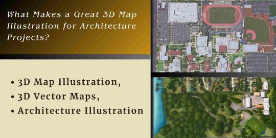
Beyond the Blueprint: What Makes a Great 3D Map Illustration for Architecture Projects?
Architects, developers, and city planners must convey complex spatial relationships, proposed designs, and overarching visions to a diverse audience – from technical stakeholders and investors to community members and potential residents. While traditional blueprints and floor plans are essential, they often fall short in providing an immediate, intuitive understanding of a project's scale, context, and aesthetic impact. This is where the power of a great 3D Map Illustration shines, transforming abstract data into compelling visual narratives.
A truly effective 3D Map Illustration for an architecture project is more than just a pretty picture; it's a strategic communication tool that clarifies, persuades, and inspires. It elevates the understanding of a design from two dimensions to three, integrating it seamlessly into its surrounding environment.
The Evolution of Architectural Visuals: From Flat to immersive
For decades, Architecture Illustration primarily meant hand-drawn perspectives or technical CAD drawings. These were invaluable for internal design processes but often lacked the visual appeal and contextual richness needed to engage broader audiences.
The real game-changer came with the integration of detailed topographical data and 3D modeling into map-making. This led to the development of 3D Vector Maps, which are not only geographically accurate but also visually rich, allowing architects to showcase their designs within a comprehensive, real-world context. This shift from isolated building views to integrated urban landscapes is what makes a great 3D Map Illustration so powerful for architecture projects.
Core Elements of a Great 3D Map Illustration
Creating an impactful 3D Map Illustration requires a blend of technical precision, artistic flair, and a deep understanding of the project's communication goals. Here are the key elements that set a great illustration apart:
Accuracy and Data Integrity:
The foundation of any great 3D Map Illustration is impeccable accuracy. Leveraging accurate GIS data, drone surveys, and meticulously crafted 3D Vector Maps ensures that every element is spatially correct.
Contextual Richness and Environmental Integration:
A standalone building render tells only part of the story. A great 3D Map Illustration places the architectural project firmly within its surroundings. This includes:
Existing Urban Fabric:
Depicting neighboring buildings, streetscapes, parks, and natural features helps stakeholders understand how the new development will interact with its environment.
Landscape Design:
The map should highlight how the project enhances or respects the natural landscape.
Connectivity:
Roads, public transport routes, and pedestrian access points should be clearly illustrated, showing how the project connects to the wider infrastructure. This contextual depth makes the illustration a comprehensive Architecture Illustration of the project's impact.
Clarity and Legibility:
Despite the wealth of information, a great 3D Map Illustration must remain easy to understand. This involves: .
Clear Labeling and Annotations:
Using legible text, icons, and arrows to highlight key areas, phases, or features of the project.
Effective Color Palette:
Using colors that differentiate between existing and proposed structures, green spaces, and water, while maintaining an appealing aesthetic.
Aesthetic Appeal and Visual Storytelling:
Beyond technical accuracy, a great 3D Map Illustration is also an artistic endeavor. This includes:
Realistic Lighting and Shadows:
Using lighting to create depth, mood, and to show how sun exposure might affect different parts of the project at various times of day.
Inclusion of Human Elements:
This aspect elevates the illustration from a mere technical drawing to an evocative Architecture Illustration.
Focus on the Proposed Design:
The 3D Map Illustration must clearly differentiate the proposed buildings or infrastructure from the existing environment, making it easy for the viewer to immediately identify the "new" elements. This can be achieved through distinct color palettes, bolder modeling, or highlighted lighting on the proposed structures. The goal is to clearly showcase the future.
Applications of a Great 3D Map Illustration in Architecture
A high-quality 3D Map Illustration serves multiple critical functions in an architecture project:
Master Planning and Urban Design:
For large-scale urban developments, a 3D Map Illustration provides an essential overview of how different components (residential, commercial, public spaces) interact and connect. It's invaluable for showing density, flow, and the overall master plan.
Client Presentations and Investor Pitches:
A visually stunning map instantly communicates the vision and potential of a project, helping to secure funding and buy-in from key stakeholders. It's a powerful sales tool.
Public Hearings and Community Engagement:
When presenting to local communities, a clear 3D Map Illustration demystifies complex plans, allowing residents to understand the direct impact of the project on their neighborhood, traffic flow, or green spaces.
Marketing and Sales Materials:
For real estate, a compelling 3D Map Illustration serves as a vital marketing asset, helping potential buyers understand the property's location advantages, amenities, and relationship to the surrounding area. This goes far beyond a typical Architecture Illustration focusing on just one building.
Internal Project Coordination:
Even for internal teams, a comprehensive 3D Map Illustration helps various disciplines (architects, landscape architects, civil engineers) visualize how their individual contributions fit into the larger scheme, ensuring better coordination and identifying potential conflicts.
The Process: Crafting the Perfect 3D Map Illustration
Creating a great 3D Map Illustration typically involves several stages, often handled by specialized visualization studios:
Data Collection:
Gathering precise topographical data, existing building footprints, road networks, and proposed architectural models.
3D Modeling:
Developing 3D models of all current and proposed structures, terrain, and infrastructure.
Texturing and Materials:
Applying realistic textures and materials to all surfaces to enhance visual fidelity and context.
Lighting and Composition:
Setting up lighting to create atmosphere, defining camera angles, and composing the scene to highlight key aspects of the project.
Post-Production:
Refining the image with color correction, atmospheric effects, and adding human elements to bring the scene to life. This is where the artistry of the 3D Map Illustration truly comes through.
Conclusion
In an increasingly visual world, the ability to communicate architectural visions with clarity, impact, and aesthetic appeal is paramount. A great 3D Map Illustration is no longer a luxury but an indispensable tool for architects and urban planners. By leveraging the precision of 3D Vector Maps and the artistry of skilled visualizers, these illustrations transcend mere blueprints, providing a comprehensive, compelling, and intuitive understanding of complex projects. For any architecture project aiming to truly connect with its audience, a superior 3D Map Illustration is the ultimate secret weapon, making every aspect of the design visible, understandable, and inspiring.
0 notes
Text
From Concept to Construction: The Power of Site Surveys
Introduction
In the realm of construction, infrastructure development, and urban planning, precision and foresight are essential. Every successful project begins long before the first brick is laid or the ground is broken. At the heart of this planning process lies one critical step—Site Surveys. These surveys serve as the blueprint that guides architects, engineers, contractors, and planners from initial concept to final construction. In Australia’s diverse and often challenging landscapes, the importance of comprehensive Site Surveys cannot be overstated.

What Are Site Surveys?
Site Surveys are systematic assessments and data collections carried out on a specific parcel of land before any development or construction begins. The purpose is to gather essential information regarding the physical, environmental, and legal characteristics of the site. These may include measurements, land boundaries, topographical features, existing structures, underground utilities, soil conditions, and potential hazards.
Depending on the project's nature, Site Surveys may encompass various sub-disciplines, including topographic surveys, geotechnical surveys, environmental assessments, and utility mapping. Each of these provides crucial data needed to inform design decisions, avoid costly errors, and ensure compliance with local regulations.
The Importance of Site Surveys in the Australian Context
Australia’s geographical diversity—from arid outback regions to coastal cities—makes detailed Site Surveys particularly vital. Factors such as bushfire risk zones, flood-prone areas, heritage overlays, and native vegetation laws must all be considered before a project proceeds.
Properly executed Site Surveys help identify site-specific challenges early in the planning phase. This proactive approach supports better budgeting, more accurate timelines, and smoother project approvals. Whether in urban centres like Sydney and Melbourne or remote regional areas, Site Surveys serve as the foundation of sustainable and safe development.
Stages of a Site Survey
Preliminary Research and Planning Before physical surveying begins, preliminary research is conducted to gather existing data. This includes reviewing property titles, zoning laws, previous survey records, and relevant planning schemes.
Field Data Collection Using advanced surveying instruments such as GPS, total stations, and drones, technicians collect data from the physical site. This process may involve mapping terrain, locating utilities, and identifying environmental constraints.
Data Analysis and Interpretation The collected data is processed using specialised software to produce detailed maps, 3D models, and reports. These outputs are critical for design and engineering teams to make informed decisions.
Reporting and Documentation Finally, findings are documented in a formal report, often submitted to regulatory authorities and used in planning applications, engineering designs, and construction documentation.
Benefits of Site Surveys
Risk Reduction: By uncovering potential issues such as unstable soil, heritage restrictions, or contamination, Site Surveys help mitigate risks before they become costly problems.
Design Accuracy: Architects and engineers rely on precise site data to create accurate plans that are functional, safe, and compliant.
Regulatory Compliance: Many local councils and planning authorities in Australia require certified Site Surveys as part of the development approval process.
Cost Efficiency: Early identification of challenges allows for better budgeting and minimises delays during construction.
Modern Technology in Site Surveys
Technological advancements have transformed the accuracy and efficiency of Site Surveys. The integration of drones, 3D laser scanning (LiDAR), and GIS (Geographic Information Systems) has allowed for more detailed and comprehensive assessments. These tools enable surveyors to map large or complex areas with high precision, making them invaluable in both urban and remote Australian environments.
When Are Site Surveys Required?
Site Surveys are essential for a wide range of projects, including:
Residential and commercial property development
Infrastructure and transport projects
Environmental and heritage assessments
Mining and resource exploration
Public utility installations
In each case, the survey serves a different purpose but shares a common goal: to provide accurate, reliable information for better project outcomes.
Legal and Regulatory Considerations
Australian laws and regulations surrounding land development are strict and vary by state and territory. Compliance with planning regulations, environmental laws, and safety standards often hinges on the data provided through Site Surveys. Failure to conduct proper surveys can result in legal disputes, fines, or project cancellations.
Conclusion
From conceptual design to full-scale construction, Site Surveys play an indispensable role in shaping the built environment. They offer the insight needed to plan responsibly, build safely, and meet Australia’s stringent development standards. In a landscape as varied and complex as Australia’s, thorough Site Surveys are not just a recommendation—they are a necessity.
By prioritising comprehensive Site Surveys at the earliest stages of a project, stakeholders set the stage for success. Accurate data, early risk identification, and regulatory compliance form the cornerstone of any development that is sustainable, efficient, and legally sound.
0 notes
Text
Expert Road Surveyors in Chennai | Accurate Mapping
Expert Road Surveyors in Chennai for Your Next Project
Introduction
Chennai is one of the best examples of India's rapidly expanding urban development. The city is always changing, from inner-city road improvements to national highway expansions. However, careful planning and precise data collection are essential to the success of any road infrastructure project. Expert road surveyors in Chennai can help with this.
Any road must be measured, mapped, and planned in accordance with the land's legal and physical characteristics before it is constructed, widened, or upgraded. The technical knowledge required to make that happen is supplied by road surveyors, who guarantee precise, effective, and legally compliant construction.
The significance of road surveyors, their methods, the reasons they are essential in the Chennai area, and the qualities to consider when selecting experts for your upcoming road project will all be covered in this blog.
Who Are Road Surveyors?
Professionals with extensive training in measuring and charting the physical attributes of land areas slated for road construction are known as road surveyors. Terrain levels, property lines, natural barriers, existing infrastructure, and other things are all part of their job.
Road surveyors collect and evaluate precise data using cutting-edge equipment such as GPS, Total Stations, drones, and Geographic Information Systems (GIS). Following that, this data is converted into workable plans and layouts that direct the construction crews as they build the roads.
The Role of Road Surveyors in Infrastructure Projects
Road surveyors start their work long before construction workers show up on the job site. In actuality, an infrastructure project is built on their contributions. Below is a summary of their main duties:
1. Route Planning
The most economical and feasible path for a road is decided by surveyors. This 4 researching the topography, surrounding environment, and existing buildings.
2. Legal and Boundary Assessments
They guarantee that the planned construction adheres to local and federal land regulations and remains within the actual property boundaries.
3. Topographic Mapping
In order to assist engineers in designing appropriate road gradients and drainage systems, they produce intricate maps that display land elevations, slope angles, and contours.
4. Risk Identification
Road surveyors can find possible dangers like areas that are vulnerable to flooding, unstable soil, or close to protected areas by conducting a land survey.
5. Final Reporting
Following collection and analysis, the data is put together into comprehensive reports and digital formats, such as CAD or GIS files, which are utilized all through the road building process.
Importance of Road Surveyors in Chennai
Chennai offers a distinct combination of infrastructure development opportunities and challenges. Chennai's road surveyors play an even more important role because of the city's growing suburbs, coastal plains, and traffic.
1. Diverse Terrain
Every project needs specialized surveying solutions, whether it's in the elevated terrains near Tambaram and Velachery or the flat coastal areas of East Chennai. Skilled surveyors are able to manage these variances with accuracy.
2. Regulatory Landscape
Chennai Municipal Corporation and Tamil Nadu's Public Works Department (PWD) have stringent building codes.Local road surveyors assist in ensuring compliance because they are familiar with these rules.
3. Fast-Paced Development
Road construction in Chennai needs to be completed by a certain date, whether it's for IT corridors, SEZs, or smart city initiatives. Skilled experts expedite the survey procedure to maintain a rapid pace.
Types of Road Surveys Used in Projects
Depending on the requirements of the project, a variety of techniques and kinds of road surveys are employed.Although the methods may differ, they all seek to gather high-quality information that enables precise road design.
Type of Road Survey
Purpose and Usage
Reconnaissance Survey
Initial site check to understand terrain and route feasibility
Preliminary Survey
Gathering topographic and environmental data
Detailed Engineering Survey
Complete analysis for road design, including levels and structures
Traffic Survey
Studies traffic patterns and density to design appropriate road widths
Soil & Material Testing
Determines if land and materials are suitable for road construction
These different road surveys play a critical role in the development of safe, durable, and cost-effective roadways.
Tools and Technology Used by Road Surveyors
Modern road surveying depends heavily on the integration of advanced technologies to improve accuracy and efficiency. Here's a look at the main tools used:
1. GPS & GNSS Devices
Used for real-time location tracking and geospatial data collection.
2. Total Stations
Combines theodolites and electronic distance measurement tools to measure angles and distances precisely.
3. Drones (UAVs)
Drones are used in aerial surveys to swiftly cover large areas and locate hard-to-reach terrain features.
4. AutoCAD & Civil 3D
Data collected from the field is converted into accurate digital maps and models using specialized design software.
5. GIS Mapping
Helps surveyors overlay maps with zoning, utility, environmental, and other regulatory data.
These tools allow road surveyors to provide data with accuracy margins as tight as a few millimeters—critical for urban development in space-constrained areas like Chennai.
Characteristics of a Road Surveyor
The following considerations should be made when selecting experts for your project:
Quality
The Significance of It
Local Experience
Helps navigate local regulations and land conditions
Technical Expertise
Ensures use of modern tools and accurate data interpretation
Strong Portfolio
Demonstrates experience in handling a variety of road and infrastructure projects
Timely Delivery
Prevents project delays by delivering survey data on schedule
Regulatory Knowledge
Reduces risk of legal and compliance issues later in the project lifecycle
Why JVR Land Surveys?
JVR Land Surveys is a leading name when it comes to road surveyors in Chennai. With more than a decade of experience, our team has successfully completed numerous public and private infrastructure projects across the region. Here’s what makes us the right partner for your next road project:
Complete Road Survey Solutions – From reconnaissance to final engineering layouts
Advanced Survey Equipment – Use of Total Stations, RTK GPS, and drones
Timely Execution – We respect deadlines and deliver actionable reports fast
Client-Centered Approach – Custom solutions based on your project type and budget
Experienced Team – Professionals with deep knowledge of Chennai’s geography and zoning rules
We’ve assisted in road design for industrial parks, highways, smart city zones, and commercial layouts.
Notable Projects in Chennai
Here are some high-impact projects where our road survey expertise was instrumental:
Project
Scope of Work
Location
Outer Ring Road (NH-45 to Vandalur)
Topographic survey, alignment study
South Chennai
T. Nagar Smart City Development
Road and drainage layout surveys
Central Chennai
Chennai-Bengaluru Industrial Corridor
Preliminary and drone-based survey
Western Suburbs
Marina Loop Road Beautification
Elevation and utility line mapping
Marina Beach Stretch
In each of these projects, our team provided timely, accurate, and regulation-compliant data to support successful road development.
Benefits of Investing in Professional Road Surveying
The cost of hiring expert road surveyors is often minimal compared to the savings and risk reduction they offer. Here's how:
Avoid Design Flaws – Accurate elevation and boundary data help eliminate costly rework
Stay Within Budget – Real-world data helps in precise quantity estimation
Fast-track Approvals – Complete documentation expedites permits and government clearances
Support Long-Term Planning – Survey data can be used for future maintenance and upgrades
Ensure Legal Protection – Well-documented boundaries protect against property disputes
In short, road surveys protect your investment from unexpected delays and legal troubles.
Commonly Asked Questions
Q1: What is the price of a road survey in Chennai?
A: Costs vary based on land size, terrain, and the type of survey required. Contact us for a custom quote.
Q2: Do I need a road survey for internal roads in private layouts? A: Yes. Even private layouts must follow specific road alignment and zoning laws. A survey ensures compliance and safety.
Q3: How long does it take to complete a road survey? A: For small city roads, it may take 2–3 days. Larger highway or corridor projects can take several weeks.
Q4: Will I receive digital outputs from the survey? A: Absolutely. You’ll get CAD files, PDF maps, and GIS overlays as part of your final deliverables.
Q5: Can a road survey help in reducing construction waste? A: Yes. Knowing the exact slope, materials needed, and design before construction reduces errors and excess material use.
Conclusion
As Chennai grows and gets more urbanized,road construction will remain a crucial component of infrastructure planning.The outcome of a project,whether it is private or municipal, can be significantly impacted by working with certified road surveyors in Chennai.
In addition to their professional expertise,these experts provide accuracy,compliance, and reliability.You are creating the foundation for safer roads, simpler construction,and long-term cost savings by hiring certified road surveyors.
Moreover,JVR Land Surveys offers cutting-edge technology, a dedication to excellence, and demonstrated proficiency in identifying a reputable name in Chennai.
0 notes
Text
How Civil Engineers Use CAD to Design Roads, Bridges & Infrastructure

If you’ve ever driven on a highway, crossed a bridge, or walked on a neatly paved sidewalk, there’s a high chance that CAD had something to do with it. While these structures might seem like basic parts of everyday life, they’re the result of intricate planning, coordination, and precision, most of which happens long before the first shovel hits the ground. And that planning? It often revolves around Computer-Aided Design, better known as CAD.
Let’s dig into how civil engineers use CAD to turn rough sketches and raw land into the roads, bridges, and infrastructure we all rely on.
What Exactly Is CAD?
Before we get ahead of ourselves, here’s a quick refresher: CAD stands for Computer-Aided Design. It’s software that allows engineers, architects, and designers to create, modify, analyze, and optimize designs digitally. Think of it like a digital drafting table—but with layers of intelligence, data, and precision built in.
For civil engineers, CAD isn't just a tool—it’s a core part of how they bring ideas to life.
Laying the Groundwork: Survey Data to Base Maps
The process usually starts with gathering real-world data. Civil engineers use topographical surveys, GIS data, drone imagery, and satellite maps. This data is imported into CAD platforms like AutoCAD Civil 3D, Bentley MicroStation, or InfraWorks.
CAD helps convert all this into a clear, layered base map. These maps display everything from elevation changes and soil types to utility lines and environmental zones. It’s not glamorous work, but it’s essential. Roads and bridges need to fit the landscape they’re built on, not fight it.
Planning Roads: It’s More Than Just Drawing a Line
Designing a road might sound straightforward, draw a line from point A to point B—but in practice, it’s a logistical puzzle with safety, efficiency, cost, and sustainability all in play.
With CAD, engineers can model horizontal alignments (where the road goes side to side) and vertical alignments (how it goes up and down). They factor in slopes, curves, drainage, and even traffic flow. Want to see what happens if you add an extra lane or move an intersection? CAD lets engineers simulate and test changes before committing to expensive builds.
One real-world example: in urban areas where space is limited, engineers use CAD to design multi-layered solutions like flyovers and underpasses. With 3D modeling, they can visualize how these structures will interact with existing roads, utilities, and buildings—all before a single cone is placed on the street.
Building Bridges: CAD for the Complex Stuff
Bridge design is where CAD truly shines. Bridges aren’t just functional—they’re complex structures balancing physics, loads, materials, and aesthetics. And each bridge has its unique challenges depending on location, length, span type, and environmental factors like wind, water flow, and seismic activity.
Using CAD, civil engineers model different bridge types (suspension, beam, truss, arch) and test structural performance. Programs like Revit, Civil 3D, and Tekla Structures enable engineers to simulate load distribution, material stresses, and environmental impacts.
Even better, 3D models created in CAD can be used for clash detection. That means identifying potential conflicts, like a beam that intersects with a utility line, before construction begins. It’s like having a crystal ball that prevents expensive surprises.
Coordinating Infrastructure: The Bigger Picture
Planning roads and bridges is just one piece of a much larger infrastructure puzzle. CAD is the platform where civil engineers coordinate everything else: stormwater management, sewer systems, electrical grids, fiber optics, bike paths, and even landscaping.
In large infrastructure projects, coordination is everything. Civil engineers use CAD to overlay multiple design disciplines—mechanical, electrical, plumbing, and structural—onto the same digital model. This kind of integrated approach prevents issues down the road (literally), where, say, a drainage pipe might interfere with a foundation if not caught early.
Real-Time Collaboration and BIM Integration
Modern CAD tools are more collaborative than ever. Engineers, architects, contractors, and city planners can work from a single shared model. With tools like Building Information Modeling (BIM), CAD evolves from a drawing tool into a smart ecosystem that tracks materials, schedules, and costs.
For instance, if a road design changes, the CAD model can automatically update related documents—material takeoffs, cost estimates, and construction schedules, saving hours of manual recalculation. That’s the kind of smart, connected workflow that’s becoming standard in infrastructure projects worldwide.
Going Beyond the Screen: From CAD to the Real World
Once designs are finalized, CAD doesn’t get filed away—it becomes a blueprint for action. Contractors use it to guide machinery, surveyors use it to stake out alignments, and city officials use it to review and approve plans.
Even during construction, CAD models remain crucial. Engineers refer to them to troubleshoot problems, coordinate deliveries, and track progress. Some advanced systems even link CAD models to GPS and machine control, letting bulldozers and graders follow digital designs with pinpoint accuracy.
Final Thoughts: Why It Matters
At first glance, CAD might seem like just another software tool, but in civil engineering, it’s transformative. It allows professionals to design with precision, test assumptions, avoid costly mistakes, and deliver safer, more efficient infrastructure.
Whether it's a rural highway, a city overpass, or a flood control system, CAD helps civil engineers think ahead, turning raw data into the roads we drive, the bridges we cross, and the infrastructure that quietly supports modern life.
So next time you're cruising down a smooth road or admiring a bridge’s sleek silhouette, remember: someone carefully designed it with CAD, long before the first bolt was tightened.
#CivilEngineering#CADDesign#InfrastructurePlanning#EngineeringLife#BridgeDesign#RoadEngineering#StructuralDesign#AutoCAD#Civil3D#EngineeringInnovation
0 notes
Text
From Concept to Construction: The Role of Precise Land Survey Drafting

In high-stakes land development and infrastructure delivery, precision in survey documentation is not negotiable—it’s fundamental to technical accuracy, regulatory compliance, and project viability. Land survey drafting is the translation layer that converts complex geospatial datasets into construction-grade CAD deliverables, enabling planners, engineers, and contractors to operate with confidence.
At Alada Solutions, our drafting workflows are designed to integrate seamlessly into civil engineering and land development pipelines, ensuring spatial consistency, design intent validation, and alignment with jurisdictional standards. This article explores how advanced land survey drafting underpins every phase of the construction lifecycle—from entitlement to execution.
Land Survey Drafting as a Critical Data Integration Function
Modern land survey drafting is not merely a drafting service it is a high-precision data interpretation process that ensures geospatial accuracy, legal defensibility, and seamless handoff to engineering and design platforms. Drafting professionals work with raw geodetic inputs, including GNSS data, LiDAR scans, and conventional total station outputs, transforming them into multi-layered CAD files that conform to ALTA/NSPS standards, local zoning codes, and engineering baselines.
These deliverables are critical to:
Defining buildable limits and constraints within entitlement packages
Ensuring horizontal and vertical control for grading, drainage, and utility design
Facilitating permitting and regulatory reviews by providing clean, accurate base maps
Maintaining continuity between survey field crews, engineering teams, and construction contractors
At Alada, our survey drafting experts are not just CAD technicians, they are spatial problem solvers trained to interpret legal descriptions, resolve field discrepancies, and build datasets that are interoperable with GIS systems, Civil 3D environments, and BIM workflows. Our deliverables serve as the foundation for all downstream design, coordination, and construction activities.
Land Survey Drafting Support
The Life Cycle: From Concept to Construction
Precise survey drafting supports every phase of a development or construction project:
1. Feasibility & Planning
Boundary surveys, zoning overlays, and land title data
Help stakeholders assess site constraints early
2. Design & Engineering
Topographic data and contours for architects and engineers
Utility mapping for drainage, roads, and site grading
3. Pre-Construction
Plotting layout plans and staking coordinates
Construction-ready survey plans for field execution
4. Construction & As-Built Verification
Revisions based on site conditions
As-built drawings for final inspection and handoff
Case Insight: A land developer in Texas approached us for urgent updates to grading plans due to unexpected elevation changes on-site. Our drafting team delivered the revision within 36 hours, enabling construction to stay on schedule.
Common Challenges in Survey Drafting
From working with surveying companies across the U.S., we’ve noticed some recurring challenges:
Discrepancies between field notes and CAD interpretation
Outdated or inconsistent drafting standards
Miscommunication between field teams and office drafters
High-volume projects needing quick turnaround without errors
“Alada uses a standardized layering system and quality control checklist, reducing rework by up to 40% for our survey partners.”
Why Teams Trust Alada Solutions
Why do surveying companies, CAD managers, and land developers across the USA trust us?
Deep understanding of local and national survey standards (ALTA/NSPS, FEMA, etc.)
Dedicated CAD team trained in land development and civil engineering workflows
Flexible and scalable support for urgent or high-volume drafting needs
Seamless communication with field crews and survey managers
Our drafters come from both design and field backgrounds. We know what matters at every step.
Conclusion
When land survey drafting is done right, everything else moves forward with confidence. Survey managers waste less time on revisions. Developers reduce costly delays. CAD teams stay focused on quality.
If you’re looking for a land survey drafting company that understands your field-to-office workflow and delivers consistent, accurate results Alada Solutions is here to partner with you.
0 notes
Text
How GIS Technology is Transforming the UAE Landscape? Learn How Data Processing Shapes the Future
Picture how at dawn, a surveyor watches the sun cast its shadows over Dubai from atop the Burj Khalifa. The data below describes a nation that turned deserts into shining cities within a short period. This is a real story because GIS Surveys and Data Processing make a big difference in planning, constructing, and managing cities in the UAE.
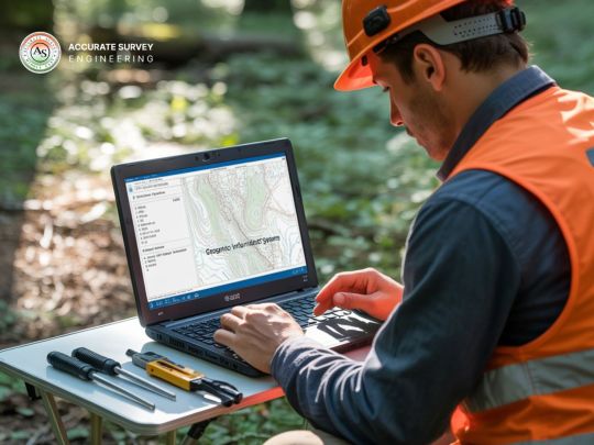
The Overview of Smart Cities
The smart city initiatives in every emirate in the United Arab Emirates rely heavily on Geographic Information Systems (GIS). In Dubai and Abu Dhabi, GIS surveys help ensure that decision-makers in these cities use spatial data effectively.
Today, GIS surveys in the UAE gather information about buildings, roads, the environment, and the population’s demographics. As a result, this system helps city planners organize all the parts of the city more efficiently and make the city a nicer place for its people.
Advanced Methods for Surveying in the Desert
GIS professionals in the UAE have to deal with challenges and take advantage of the country’s unique geography. In view of the country’s fast development and its arid climate, the need for precise and quick data collection is inevitable. Surveying equipment used today is equipped with advanced technologies.
LiDAR Technology: millions of precise points are collected about what is on the ground which is then used to form highly detailed 3D images. This technology has helped to track the many changes in the UAE’s landscape, from near the sea to far within the mountains.
Merging Satellite Photos and Data: Using high-resolution satellite images, real-time information about land use is obtained and used to improve maps that track China’s fast growth. It allows authorities to observe how things are progressing in the city, follow how it is growing, and notice any changes in the environment.
Mobile Mapping Systems: Sensors installed on vehicles gather data from the streets, resulting in complete databases of different parts of a road network. In highly congested urban places, these systems can be more useful than traditional types of surveying.
Data Processing: From Raw Information to Actionable Intelligence
GIS is particularly useful because it makes collecting data meaningful through processing large volumes of spatial information. Most recent survey methods create large datasets, but the UAE can now process this data with ease.
Thanks to cloud processing, those responsible can quickly look at results from the survey and make decisions based on conditions as they stand. Thanks to machine learning, it becomes easier to plan for future challenges rather than respond only to them as they occur.
GIS maps are updated frequently when paired with IoT sensors. Understanding the complexity of cities improves by using smart traffic systems, monitoring environmental conditions, and overseeing utilities.
Relevant uses of AI making a difference in the Emirates
Many important projects in the UAE demonstrate the effects of advanced GIS technology.
Infrastructure Planning: Using GIS, engineers can design plans for new transport and utility structures to ensure they cause the least disturbance possible. By relying on detailed maps of the area, the Dubai Metro team was able to prevent hitting important infrastructure.
Environmental Monitoring: GIS is used to monitor the weakness of coastal areas, the quality of the air, and the management of water supplies in this part of the world. By using this technology, the UAE gathers relevant information for sustainable environmental protection.
Emergency Response: If spatial data is correct, emergency teams can respond more swiftly and plan better for any disaster. GIS was essential for health officials to observe the spread of COVID-19 and select the most suitable locations for testing and vaccination centers.
Economic Development: GIS tools help free zones and business districts attract investors by displaying their infrastructure and the available opportunities. Due to its spatial intelligence, the UAE ranks as a leading business hub around the world.
Studying Challenges and Future Opportunities
While there has been significant progress, there are still difficulties in using GIS in the UAE. It is important to standardize data collected in all emirates, connect older systems and hire skilled staff. Yet, efforts such as the National Spatial Data Infrastructure in the UAE are helping overcome these problems step by step.
In the future, new technology is set to offer more advanced features. Artificial intelligence will help in extracting more information automatically from the data collected in surveys. With digital twin technology, we will be able to generate virtual cities that can be used for planning and supervising different situations.
Choosing the GIS Surveying Experts
With the help of spatial technology, the UAE made the leap from a desert to an international city. While the nation advances in city development and new technology, GIS Survey and Data Processing in UAE will play a key role in helping it grow.
GIS nowadays not only tracks the changes happening in the UAE; it also helps drive them forward. Thanks to spatial intelligence, the Emirates is set to make progress in both sustainable development and management of resources, aiming to create an extraordinary future.
GIS technologies are set to revolutionize urban development and other aspects of innovation in the UAE. If you would like to learn more about GIS surveying and data processing in UAE you can visit the page.
0 notes
Text
Buraq Integrated Solutions

Buraq Integrated Solutions is a premier system integration, professional services, and software development company, offering cutting-edge technology solutions across multiple industries. Specializing in Industrial Automation, Automatic Weather Stations, Flood Early Warning Systems, PLC/SCADA, and IT Consultancy, Buraq Integrated Solutions provides tailored services to government bodies, financial institutions, telecom providers, energy sectors, healthcare, and educational institutions. With a commitment to delivering reliable, rapid, and robust solutions, Buraq Integrated Solutions has established itself as a trusted partner for businesses and government organizations seeking to enhance efficiency through automation and advanced technology. Comprehensive Solutions for Various Industries As a technology-intensive company, Buraq Integrated Solutions offers a diverse portfolio of services designed to meet the evolving needs of its clients. The company specializes in: 1. Industrial Automation & Control Systems - PLC Programming & SCADA Systems – Advanced industrial automation solutions for seamless control and monitoring. - HMI (Human-Machine Interface) – Intuitive systems for process control and operational efficiency. - Telemetry Systems – Real-time data acquisition and remote monitoring solutions. 2. Automatic Weather Stations & Flood Early Warning Systems - Environmental Monitoring Systems – Providing accurate weather data for improved forecasting. - Flood Early Warning Systems – Enhancing disaster preparedness through real-time flood detection technology. - GIS Survey & Mapping – Geographic Information Systems (GIS) for land and infrastructure analysis. 3. IT Consultancy & Software Development - Custom Software Solutions – Tailored applications for financial services, government institutions, and enterprise operations. - Cybersecurity & Data Protection – Ensuring the integrity and security of IT infrastructure. - Cloud-Based Solutions – Scalable and efficient cloud computing services for businesses. Industries We Serve Buraq Integrated Solutions delivers advanced technological solutions to a broad range of industries, ensuring efficiency, security, and automation in key sectors: Government (Local & Central): We provide digital transformation solutions that enhance the efficiency and effectiveness of local and central government operations. Financial Services: Our solutions help banks, insurance companies, and clearing houses streamline operations, reduce risks, and improve customer service. Telecommunications: We enable telecom companies to optimize their networks, improve service delivery, and stay competitive in a rapidly evolving industry. Energy & Utilities: Our solutions help energy providers and utilities improve operational efficiency, reduce costs, and enhance sustainability. Healthcare: We deliver technology solutions that improve patient care, streamline operations, and ensure compliance with regulatory requirements. Education: Our solutions help educational institutions enhance learning experiences, improve administrative efficiency, and prepare students for the future. Why Choose Buraq Integrated Solutions? ✔ Proven Expertise – A team of highly skilled professionals with vast industry experience. ✔ Innovative Technology – Implementation of the latest advancements in industrial automation and IT solutions. ✔ Custom-Tailored Solutions – Designed to meet the unique needs of each client. ✔ Reliable & Scalable Systems – Ensuring long-term efficiency and adaptability. ✔ Commitment to Excellence – Delivering quality-driven solutions that maximize performance. Get in Touch Buraq Integrated Solutions is your trusted partner for advanced technology solutions. Whether you need automation, IT consultancy, or environmental monitoring, we have the expertise to deliver state-of-the-art solutions that work. For inquiries, consultations, or collaborations, contact us today! Read the full article
0 notes