#GeoTech
Explore tagged Tumblr posts
Visit Tumblr Blog
Explore Tumblr blogs with no restrictions, modern design and the best experience.
Last Seen Tumblr Blogs


Fun Fact
1,644 Tumblr posts in 1 second.
Text
I was in a conversation about getting people into geoscience as more and more programs close across the world, and I have a hypothesis that most people in geology now were either able to travel, or experience different landscapes as they grew up.
-=-
34 notes
·
View notes
Text
Pemantauan Lereng Tanah dengan Inclinometer untuk Proyek Konstruksi yang Lebih Aman

Dalam dunia konstruksi dan geoteknik, keselamatan struktur sangat bergantung pada kondisi tanah di sekitarnya. Salah satu ancaman terbesar adalah pergerakan tanah atau longsor yang terjadi secara perlahan dan tidak terdeteksi secara visual. Di sinilah peran penting alat inclinometermulai terlihat.
Inclinometeradalah alat ukur geoteknik yang digunakan untuk memantau pergerakan horizontal tanah atau struktur di bawah permukaan. Alat ini bekerja dengan cara mengukur perubahan sudut kemiringan dari pipa inclinometer yang ditanam di dalam tanah.
Dari data tersebut, para ahli dapat mendeteksi apakah ada pergeseran tanah yang berpotensi membahayakan fondasi bangunan, dinding penahan, tanggul, atau lereng jalan raya.
Penggunaan inclinometersangat umum pada proyek infrastruktur seperti pembangunan bendungan, terowongan, jalan tol di daerah perbukitan, serta pada proyek pemukiman di lereng curam. Alat ini mampu memberikan data real-time yang sangat membantu dalam pengambilan keputusan teknis dan mitigasi bencana sejak dini.
Selain itu, data dari inclinometerjuga dapat dikombinasikan dengan sistem pemantauan lainnya seperti piezometer atau extensometer untuk memperoleh gambaran menyeluruh mengenai stabilitas tanah.
Jika Anda sedang merencanakan proyek konstruksi di daerah rawan longsor atau memiliki kebutuhan pemantauan pergerakan tanah secara berkala, menggunakan inclinometeradalah solusi yang tepat dan efisien.
ALATUJIGEOTEKNIKsebagai perusahaan yang bergerak dibidang control dana monitroing system, kami menyediakan serta jual Sensor Inclinometer dengan harga dan kualitas terbaik. Serta kami menyediakan jasa instalasi pada alat uji. Untuk informasi lebih lanjut silahkan hubungi kami.
DISINI
1 note
·
View note
Text
The Essential Role of National Parks in Conservation and Sustainability

National parks are vital for conserving biodiversity, preserving natural landscapes, and providing spaces where people can connect with the environment. These protected areas serve as sanctuaries for endangered species, geological wonders, and cultural heritage. By supporting sustainable tourism, scientific research, and environmental education, they foster a sense of stewardship for future generations.
Understanding the Importance of National Parks
National parks are designated to protect ecological integrity while ensuring public enjoyment of pristine natural areas. As urbanization and climate change accelerate, these parks offer controlled environments to monitor ecological shifts, protect critical habitats, and test conservation strategies. They also boost eco-friendly economies through tourism and community-based conservation efforts.
Key Contributions of National Parks
National parks impact various aspects of society and the environment:
Biodiversity Conservation: Protect ecosystems, endangered species, and genetic diversity.
Climate Change Research: Serve as natural laboratories to study ecological responses.
Recreation and Tourism: Provide outdoor activities that support health and well-being.
Cultural Heritage Preservation: Safeguard historic landmarks and indigenous knowledge.
Environmental Education: Teach about ecosystems, sustainability, and conservation.
Community Development: Generate jobs and support sustainable livelihoods.
Creating GIS-Based Maps of National Parks: A Comprehensive Guide
The first step in mapping national parks is choosing important locations based on their ecological significance, state of conservation, and worldwide significance. To guarantee accurate placement on maps, precise geographic coordinates are gathered from reliable sources. Each park is manually added as an add point feature using a GIS platform. It has a new location type called "National Park" and features like "Animals Found," as well as a description and an image that is pertinent. Techniques for point customization, such as different color schemes, symbols, and labels, enhance clarity and facilitate map navigation. These visual elements allow users to explore and compare parks globally. Once the mapping is complete, the project can be published and shared through digital platforms, supporting conservation planning, environmental education, tourism development, and greater public engagement with protected areas.

Use Case: Empowering Indigenous Communities through GIS Mapping
An Indigenous community seeks to reclaim and manage its ancestral lands designated as national parks. Utilizing GIS mapping, the community identifies key areas of cultural and ecological significance, overlays historical land use data, and assesses current conservation status. This information empowers the community to engage in informed discussions with policymakers, advocate for the recognition of traditional ecological knowledge, and develop sustainable land management plans that honor their heritage and promote biodiversity conservation.
Discover Tools for Mapping National Parks
Crafting detailed and informative maps of national parks has become more accessible through online GIS platforms like MAPOG. These tools empower users to layer data, manage geographic points, and analyze patterns, facilitating the exploration and promotion of protected areas. Such platforms enhance public engagement and informed decision-making.
Ready to map or explore national parks? Start your journey and discover the world’s most captivating landscapes from a new vantage point!
Final Thoughts
Mapping national parks using GIS transforms how we see and understand protected areas. Interactive maps highlight ecological zones, tourism opportunities, and conservation priorities. They serve as powerful tools for park managers, researchers, and eco-tourists to make informed decisions that ensure the protection of natural heritage for generations to come.
#NationalParks#SmartMapping#SustainableTourism#BiodiversityConservation#GeoTech#InteractiveMaps#MAPOG#ClimateResilience#EnvironmentalEducation#EcoTourism#NaturePreservation#ConservationPlanning
0 notes
Text
Geotech Engineering and Testing (GET) is a diverse group of licensed engineers, geologists, field and lab technicians, and administrative staff who pool their technical expertise, collective experience, dedication, and passion to provide top-notch service through collaborative teamwork. GET employs approximately 60 professionals, including engineers, geologists, technicians, and support personnel. Their projects span a wide range, including public infrastructure, residential and educational developments, medical facilities, petrochemical complexes, renewable energy installations (such as wind turbines and solar farms), retail chains, transportation infrastructure, commercial and industrial developments, port and harbor facilities, aviation, and both high-rise and low-rise buildings.
Website - https://geotecheng.com/
0 notes
Text
Berkenalan dengan Profesi GEOLOG
Geologist atau geolog adalah orang yang bekerja/ berkarir/ menjalani hidup di bidang geologi. Saya memaknai geologi secara luas. Tidak hanya terbatas pada pekerjaan lapangan, tetapi juga bagaimana dia bisa menulis temuannya agar diketahui banyak orang. Geolog belajar segala sesuatu berkaitan dengan bumi. Saya juga belajar tentang meteorologi, oseanografi, dan astronomi. Selama ini banyak orang…
View On WordPress
0 notes
Text
There is approximately 5420 square miles in a penis assuming the length begins east of Kansas City, the shaft extends 50 miles either side of highway 70, and the balls extend across the St. Louis area.
1 note
·
View note
Text
One for each sampling to help verify the drillers' shitty blowcounts.
How many archaeologists does it take to record a geotechnical bore?
No, really, how many? Because there are currently 5 of us here.
#your geologist will appreciate it anyway xD#geotech#(I only had one archaeologist assigned per site personally)
82 notes
·
View notes
Text
Looking up waterfront homes for a laugh, this listing shocked me to my core
https://redf.in/GgD6P0


44 notes
·
View notes
Text
mom: just making sure you're up
me, sitting here in my suit jacket with my document of notes up, anxiously awaiting Meeting: i just might be
#asdghjdsdfgh#i have a Casual Discussion Meeting with a local geotech department of a big company and im gonna be So Calm And Professional#the prophet speaks
11 notes
·
View notes
Text
my face hurts, my nose is dripping like a leaky faucet, and i’ve got a mild-grade fever. i also have a midterm today ✌️
haha
(fuck my life)
#jyot writes#pray for me y’all#it’s also a midterm for a course i hate#geotech eng can go fuck itself#personal#ramblings
3 notes
·
View notes
Text
Sandy loam still being on this “version” of a USDA soil chart is objectively very funny.

theyre in a polycule
88K notes
·
View notes
Text
the one good thing about geotech is that I don’t have to deal with my annoying ass coworkers in cultural resources
like at least the geologists and engineers know how to fucking act
#they’re literally all so fucking cringe#I’m sorry that’s mean but like#fuck dude#geotech is hard but at least I get to talk to well adjusted adults
0 notes
Text
Geo Tech Engineering Helping you Build Strong Structures

Deciding on the right partner for your construction projects can make a world of difference. With geo tech engineering at its core, Cevisco provides unparalleled insights into soil and geological materials. Our services ensure your structures stand strong and safe, reducing the risk of unexpected challenges. By understanding the earth’s materials, we offer clear recommendations for foundation design, slope stability, and earthworks. This approach not only minimises project costs but also maximises efficiency. At Cevisco, our commitment is to deliver practical solutions through our expert consultancy, ensuring your projects are completed smoothly and on time. Choose Cevisco, where geo tech engineering meets innovative solutions for building success.
0 notes
Text
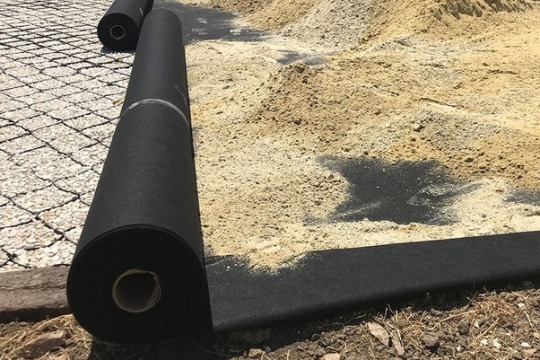
Is Geotextile Fabric the Same as Landscape Fabric?
Shankar Packaging provides details on Geotextile Fabric vs Landscape Fabric. Geotextile fabric and landscape fabric have similar properties but both are different. Geotextile is used in various construction and engineering applications. For More Information visit our blog!
#geotextile landscape fabric#PP non woven geotextile#non woven or woven geotech fabric#Geotextile Fabric vs Landscape Fabric
0 notes
Text
Geotechnical Engineer - What Does a Geotechnical Engineer Do?
A Geotechnical Engineer is a Civil Engineering professional who specializes in the study of soil. They are able to determine whether a site is suitable for construction projects. They also help to design and construct buildings, roads, tunnels and dams.
Typically, they are employed full-time with a dedicated organization, which may supply specialty equipment and provide other services. They often work in the field and need to be comfortable working in most weather conditions.
Job description
The job details of a geotechnical engineer involve using scientific methods and principles to collect and interpret data that might affect a construction project. They often work on buildings, roads, dams, and other structures. They are also involved in identifying geological hazards like landslides and earthquakes. They also help with environmental projects such as waste water treatment plants and mining.
Some of the duties of a geotechnical engineer include developing a strategic investigation plan and performing field investigations. They must be willing to travel and spend a long time on site and should have excellent communication skills. Geotechnical engineers are also required to meet clients regularly.
Many geotechnical engineers begin their career with an apprenticeship or an engineering technician role. They can gain additional experience by participating in internships or working as an assistant to a geotechnical engineer. Those seeking to advance their careers can look into leadership roles or starting their own company. They can also seek out professional development opportunities and participate in conferences.
Education requirements
Geotechnical engineering is a branch of Civil Engineering, and as such it shares many of the same core STEM subjects. It is recommended that any engineer seeking a career in this field takes at least a BS degree and considers taking minors in math, physics, and environmental science to ensure they have a strong background in these core subject areas.
Many engineers choose to pursue a graduate certificate in geotechnical engineering, as it can help them advance in their careers. In addition, it may be helpful to find an engineering continuing education course provider that offers live webinars. Most state boards will accept these types of courses for engineering CEUs, but it is important to check with your board before enrolling.
Most states require engineers to obtain licensure, which typically involves completing a four-year accredited engineering program and gaining work experience. Once an engineer completes the required number of years of documented work, they can take a professional engineering exam and become licensed as a Registered Professional Geotechnical Engineer.
Work environment
During fieldwork, geotechnical engineers work in a variety of weather conditions. They use a range of tools including rock sampling drills, sediment corers and magnetic surveying equipment. They also use a variety of computer software for research and data management.
Working with a team of other engineers and geologists, you’ll plan a wide variety of structures for mining operations and civil engineering construction projects. You’ll analyse the natural geology of each location and design foundations for a project’s specific conditions.
As you gain experience, you’ll specialise in infrastructure such as railways and roads. You’ll also focus on renewable energy, offshore and onshore oil and gas and nuclear power.
As the primary point of contact for emergent slope failures, washouts or sinkholes that may impact FirstEnergy assets, you’ll hire and oversee geotechnical consultants and prepare geotechnical designs. You’ll also manage site investigation contractors and liaise with project teams. You’ll also participate in design reviews, peer assists and technical audits.
Salary
The salary of a geotech engineer varies depending on the type of employer and level of experience. You can increase your earning potential by obtaining advanced degrees or gaining experience in the field.
Geotechnical engineering is a branch of civil engineering that deals with the engineering behaviour of Earth materials, particularly soil. It incorporates knowledge of geology, hydrology and more. It also draws from the disciplines of engineering geology, civil engineering and soil mechanics.
Structural, geotechnical and transportation civil engineering are essential areas of expertise that help mitigate the effects of natural disasters such as earthquakes, floods and hurricanes. Geotechnical engineers are intimately involved in every high-profile building project around the world. This is not an easy feat, and the work that they do is crucial to human civilization.
1 note
·
View note
Text
YES. THEY SHOULD.
The variation in a city's soil over 20 feet is just as fascinating as the variations in bedrock over the same distance! Sands are nice to build on, but rarely consistent over a distance and the percentages of fine-grained sediment will vary. Every time a building is built, landowners need to obtain a geotechnical report that corresponds to the foundation and weight of the building.
Silts have low plastic index; clays are high. Fat Clays or "highly plastic" soils can swell and retract when water is added. If you have too much fat clay too close to your foundation, the soil will buckle and destabilize the whole structure.
While it'd be difficult to get an accurate 3D model of inner-city soil strata, it would be so fun to see maps of fat clays and coarse sands. And cities should absolutely make it known what their particular soils look like!
(I've logged a lot of Silty-Sandy Gravel in my life thanks to My City.)
There should be designated soil holes for looking at your local soil layers. If I want to see what the vertical soil structure near me is like I think this is just impossible for me. You'd need some sort of...glass retaining wall? Or something? Or I guess one of those corers
#THRILLED TO BE TAGGED. I fucking love this idea. Yes yes yes. Probably preaching to the choir to OPs but explanation for non-geos#Soil sed strat is SO INTERESTING I wished so badly to have 3D modeling software of the geotech city I worked in#I wanted to see where the fat clay layers were and where the coarse sand was and where that STUPID malleable loamy silt layer stopped#I'm still mad that the dirt I could ROLL INTO A BALL tested as SILT for a whole 3 acre field. Fucking clayey-silt.#Anyway. Yes. city hall. soil samples. 10/10. My tax dollars should go to this.#geology#geogift
720 notes
·
View notes