#MAPOG
Text
GIS Analysis in Urban Planning: Reshaping Transportation Future Insights of state/city
In the heart of urban development, where cityscapes and transportation networks intersect, the transformative influence of GIS analysis in urban planning takes center stage. This article delves into the intricacies of reshaping the transportation future through the lens of MAPOG GIS tool, unraveling critical insights that hold the potential to redefine the landscape of [State/City].
Key Concept: Our mission is clear: to enhance the synergy between buses, trains, and settlements across city/state. MAPOG serves as our guide, helping create a dynamic map that illuminates the locations of bus stops and train stations, ultimately ensuring convenient access for residents of settlements.
MAPOG GIS Analysis in Urban Planning
Following are the steps for enhancing urban transportation networks through MAPOG Spatial Analysis:
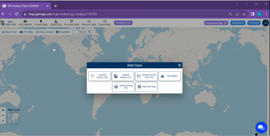
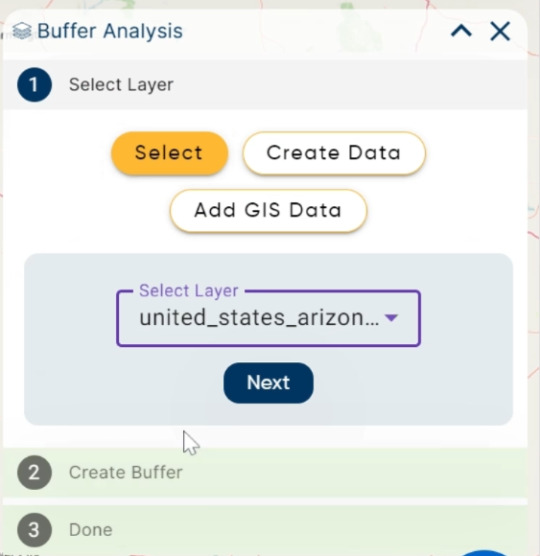
We start our journey by adding the essential data using MAPOG’s For this click on Add Upload button from top left and select Add GIS Data.
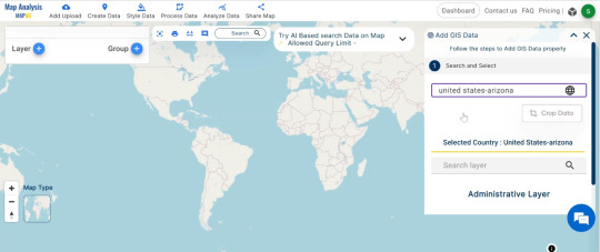
Now search for the desired data. I am using United States Arizona Gis data.
From bus stops and train stations to roads and settlements, each piece of information is carefully integrated. With data in place, the next step is to make the map visually appealing. We customize the appearance of bus stops and train stations using MAPOG’s styling options. A simple click, choose a style that stands out, and repeat the process for train station.

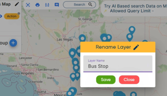
Edit the untitled Map : Edit the untitled map to ‘Urban Transportation Network Map.
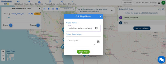
You can also edit the layer name also with click on Action Button.
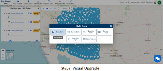
Click on Style Data, a pop up appear and choose desired style.
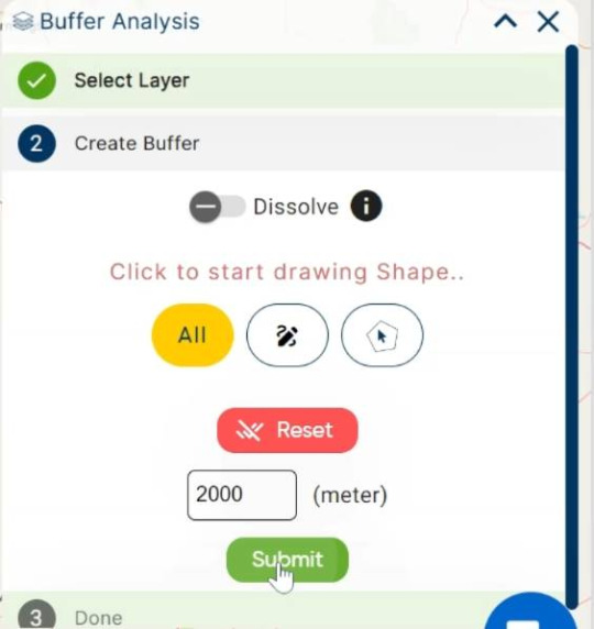
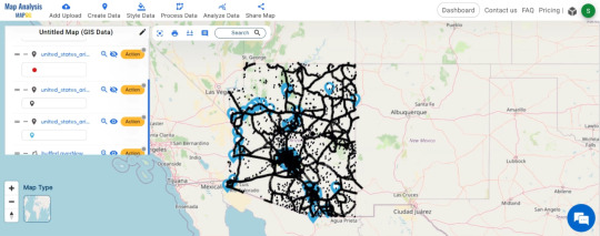
Buffer Zone: Go to Process Data and tap on BufferTool. Unveiling the influence of settlements, we create magic circles (buffers) around them using MAPOG. These buffers, set at 2000 meters, illuminate the areas touched by settlement impact. Select settlement data, apply the buffer tool, and set the distance to 2000 meters for a clearer view.
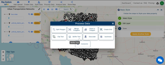
Select settlement data, apply the buffer tool, and set the distance to 2000 meters for a clearer view.
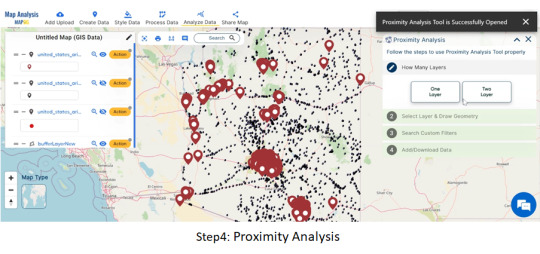
Proximity Analysis: Armed with MAPOG’s proximity analysis tool, we play detective to find the closest bus stops and train stations for each settlement.
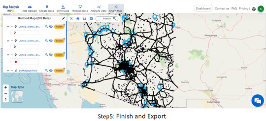
Finish and Export:
Wrapping up our journey, we finalize the map, ensuring every insight gained is captured. The “Export” option in MAPOG becomes our last step, saving and sharing the optimized transportation map with the world.
Finalize your work, choose export options, and save the optimized transportation map.
Major Findings:
Discover how settlements influence transportation areas.
Identify the nearest bus stops and train stations for settlement residents.
Understand the crucial role of roads in connecting the transportation network.
Domain and Industry:
Our expedition falls within the domains of Transportation and Urban Planning, utilizing MAPOG as our technological compass. This innovative approach integrates Geographic Information Systems (GIS) and spatial analysis to optimize the transportation network, aligning with the unique characteristics of Arizona.
Conclusion of MAPOG Gis Analysis in Urban Planning
As our Arizona transportation odyssey comes to an end, the result is a meticulously crafted map that goes beyond aesthetics. It represents a significant step towards a more efficient and accessible public transportation system. By improving connections and understanding spatial relationships, our journey with MAPOG contributes to a better, more connected Arizona.
You can also try other tool like Route Compass use in military aerial route planning or download data for anaylsis from MAPOG GIS Data.
Other Articles
Create Map – School Map Area Coverage Through Buffer Analysis
Mapping Safety Create GIS Map : Game-Changing Approach to Hospital Risk Analysis
3 notes
·
View notes
Text
Boedels en eiendom raad?
Forum: The 4x4 Pub
Posted By: Mapog
Post Time: 2024/08/11 at 09:40 PM http://dlvr.it/TBncqM
0 notes

Photo

Ang mapoge kong chicks na isusumbong ako sa Papa niya, Sugar. ✌😂🚗 #Tambay #WithSugar #BreakTime #LateUpload
0 notes
Video
youtube
On this day last year, the legendary mohawk male from the Mapogo coalition, Mr. T fought his last battle as he fell to the hands of the invading Selati Males. Hear him roar for the very last time.
RIP, Mr. T 2001-March 16, 2012
2 notes
·
View notes
Text
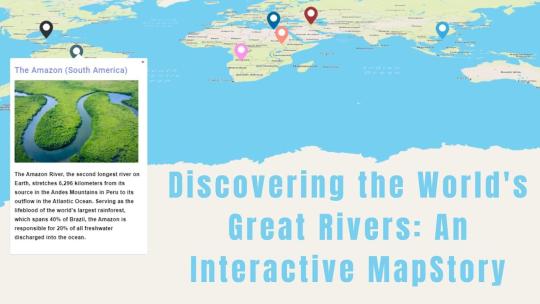
Discovering the World's Great Rivers: An Interactive MapStory
Introduction
Let's dive into the stories of some of the world’s most famous rivers using Story by MAPOG! We’ll look at the Nile, Amazon, Yangtze, Congo, Mississippi, Volga, and Danube rivers. These rivers are more than just water—they’ve shaped cultures, supported wildlife, and influenced history. With MapStory, you’ll get to see how these amazing rivers connect with our world.

The Rivers and Their Stories
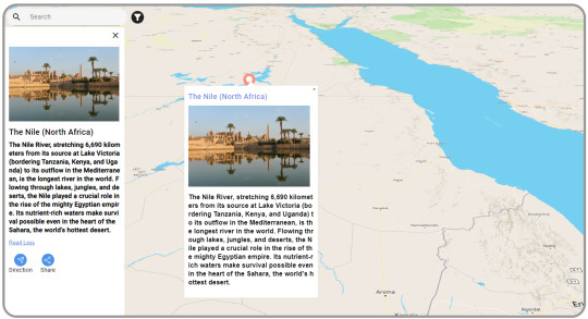
The Nile (North Africa)
The Nile is the longest river in the world. It stretches from East Africa to the Mediterranean Sea. For thousands of years, it’s been crucial for life in North Africa. The Nile provides water for farming and has helped build cities and cultures along its path.
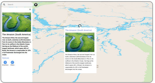
The Amazon (South America)
The Amazon is the largest river by volume. It runs through the Amazon rainforest, known for its incredible wildlife. The Amazon is vital for many plants and animals and plays a big role in regulating the Earth’s weather.
The Yangtze (China)
The Yangtze is the longest river in China. It starts in the Tibetan Plateau and flows to the East China Sea. It’s essential for farming, industry, and millions of people. The Yangtze is deeply connected to Chinese life and culture.

The Congo (Central Africa)
The Congo is Africa’s second-longest river. It’s famous for its rainforests and rich wildlife, like gorillas and elephants. The Congo is key for transportation and trade in Central Africa and helps keep local cultures vibrant.

The Mississippi (North America)
The Mississippi River runs from Minnesota to the Gulf of Mexico. It’s a big part of American history, influencing trade, transportation, and culture. The Mississippi has shaped the lives of many people in the U.S. and inspired music and traditions.

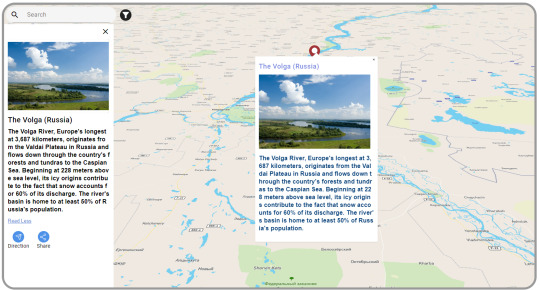
The Volga (Russia)
The Volga is Europe’s longest river. It flows through central Russia and is crucial for farming, energy, and transport. The Volga is important in Russian culture, inspiring many songs and stories.
The Danube (Central and Eastern Europe)
The Danube flows through ten countries, offering stunning views and historic cities like Vienna and Budapest. It’s been a major trade route for centuries and supports diverse wildlife. The Danube helps connect different cultures and economies.

Tool Used: MapStory
We’re using Story by MAPOG to learn about these rivers. It’s not just a map—it’s a way to tell the stories of these rivers and show what makes them unique.
How MapStory Helps
Shows Information: MapStory helps us bring together different details to highlight what makes each river special.
Engages Users: Telling stories through maps makes it easy and enjoyable to learn about the rivers’ history and importance.
Adds Photos: We can include pictures to make the stories about the rivers come to life.
Interactive Map: You can click on the map to find out more about different places and features along each river.
Customizable Stories: Each river’s story can be adjusted to fit various themes and interests, making each map unique.
Who Can Benefit
Story by MAPOG is useful for many areas. Whether you’re interested in environmental studies, education, tourism, cultural preservation, or urban planning, Story by MAPOG offers valuable insights and engaging content. It’s a great tool for anyone curious about these major rivers.
Conclusion
Learning about the world’s great rivers with Story by MAPOG is a fun way to see their beauty and importance. By combining maps with stories, Story by MAPOG helps us connect more with these rivers. For more information or to start your own MapStory journey, visit MAPOG or reach out to us at [email protected].
#GreatRivers#MapStory#MAPOG#NileRiver#AmazonRiver#YangtzeRiver#CongoRiver#MississippiRiver#VolgaRiver#DanubeRiver#InteractiveMap#CulturalHeritage#Wildlife#History#Geography#EducationalTools#Storytelling#Mapping#GlobalRivers#EnvironmentalAwareness#Tourism
1 note
·
View note
Text
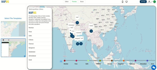
Exploring India’s Metropolitan Cities: MapStories
Introduction
Welcome to our interactive journey through India’s Metropolitan Cities using MapStory! Our goal is to create an engaging, detailed map that highlights the unique stories of India’s major urban centers. We will be exploring cities like Mumbai, Delhi, Bangalore, Chennai, and Kolkata, uncovering their rich cultures, fascinating histories, and dynamic landscapes. With story by MAPOG, we're not just mapping these cities; we're delving into the narratives that make each one special. From bustling markets and iconic landmarks to historical events and cultural traditions, our interactive map will bring the essence of these cities to life.
Tool Used: MapStory
Story by MAPOG is our companion in this exploration. It’s more than just a mapping tool; it’s a platform that blends maps with storytelling. It helps us create interactive narratives that bring to life the essence of India’s metropolitan cities.
How MapStory is Helpful
MapStory allows us to:
Visualize Data: Integrate various data sets to create dynamic maps that reveal cultural diversity, historical landmarks, and urban development.
Engage Audiences: Through storytelling, connect people with the cities, making history and culture more accessible and compelling.
Add Multimedia Elements: Incorporate photos to enrich the storytelling experience and provide a deeper understanding of each city’s unique attributes.
Interactive Features: Users can interact with the map, clicking on different points to learn more about specific locations, events, and cultural highlights.
Customizable Stories: Tailor the appearance and content of each story to fit specific themes and objectives, ensuring that each map is unique and relevant.
Domains That Can Benefit
Story by MAPOG is versatile and can be applied across various domains. Whether it's urban planning, tourism, real estate, environmental studies, transportation, education, cultural preservation, or economic development, MapStory provides valuable insights and engaging content. Its interactive and customizable features make it a powerful tool for professionals, educators, students, and anyone interested in exploring and understanding the dynamic aspects of urban environments.
Conclusion
Exploring India’s metropolitan cities through Story by MAPOG offers a captivating way to understand their dynamic nature and historical roots. By combining mapping with storytelling, MapStory enriches our connection to these cities, making it an invaluable tool across various industries. For more information or to start your own MapStory journey, visit MAPOG or contact [email protected].
#InteractiveMaps#MapStory#IndiaMetropolitanCities#UrbanExploration#Mumbai#Delhi#Bangalore#Chennai#Kolkata#CulturalMapping#HistoricalNarratives#DynamicLandscapes#GeospatialStorytelling#MAPOG#CityStories#UrbanCulture#MappingHistory#EngagingMaps#DataVisualization#MultimediaMapping#UrbanPlanning#Tourism#RealEstate#EnvironmentalStudies#Transportation#Education#CulturalPreservation#EconomicDevelopment#ExploreIndia
1 note
·
View note
Text
Countries with 100% Literacy: A Story by MAPOG
Introduction
Literacy is more than just the ability to read and write; it’s a key to personal growth and a doorway to opportunities. On International Literacy Day, we celebrate countries that have made sure every citizen can read and write. This article, brought to you with the help of Story by MAPOG, highlights these nations and how they’ve reached this impressive goal.

These Are the Countries with 100% Literacy
FinlandFinland is a shining example when it comes to education. With a 100% literacy rate, Finland’s approach focuses on student well-being and a flexible, supportive learning environment that allows every student to thrive.

NorwayNorway is another country where everyone can read and write. Thanks to its inclusive education system and equal opportunities, Norway has achieved a literacy rate of 100%, ensuring that all students get the best start in life.

LuxembourgLuxembourg’s unique multilingual education system plays a big role in its 100% literacy rate. By teaching students in multiple languages from a young age, Luxembourg ensures that literacy is embedded in their diverse culture.

UkraineUkraine has faced its share of difficulties, but it remains committed to education. Despite the challenges, Ukraine has reached a 100% literacy rate, showing that even in tough times, the dedication to learning can make a big difference.

UzbekistanIn Uzbekistan, the focus on education has paid off with a perfect literacy rate. The country has made education a priority, investing heavily in schools and teacher training to ensure that everyone has the opportunity to learn.

AndorraAndorra may be small, but it takes education seriously. With a 100% literacy rate, Andorra’s thorough and well-organized education programs ensure that all its citizens are well-equipped with essential reading and writing skills.

GreenlandEven in remote areas, Greenland ensures that everyone has access to education. By focusing on making learning available to all, Greenland has maintained a 100% literacy rate, proving that distance doesn’t have to be a barrier to education.

LiechtensteinLiechtenstein’s strong commitment to education has resulted in a perfect literacy rate. The country’s comprehensive education system ensures that all its citizens are literate, contributing to a well-informed and educated society.

North KoreaNorth Korea’s 100% literacy rate is notable, especially given the challenges the country faces. The strict education system ensures that every citizen can read and write, highlighting the importance of literacy on a global scale.

How Story by MAPOG Enhances Learning
Tool Used: MapStory
We’re using Story by MAPOG to learn about these countries. It’s not just a map—it’s a way to tell the stories of these nations and showcase what makes them stand out in education.
How MapStory Helps:
Shows Information: MapStory helps us bring together different details to highlight what makes each country’s education system special.
Engages Users: Telling stories through maps makes it easy and enjoyable to learn about these nations’ educational achievements.
Adds Photos: We can include pictures to make the stories about these countries come to life.
Interactive Map: You can click on the map to find out more about different aspects of each country’s education system.
Customizable Stories: Each country’s story can be adjusted to fit various themes and interests, making each map unique.
ConclusionThis story of countries with 100% literacy has been created using Story by MAPOG, shining a light on the incredible achievements of these nations in the world of education. As we mark International Literacy Day, these countries remind us of the power of education and what can be accomplished when it is made a priority for all.
#InternationalLiteracyDay#EducationForAll#Literacy#GlobalEducation#StoryByMAPOG#Finland#Norway#Luxembourg#Inspiration#Learning#EducationMatters
1 note
·
View note
Text
Celebrating the International Day of Happiness with STORY by MAPOG
Join us in celebrating the International Day of Happiness with Story by MAPOG! Let’s take a look at some of the happiest countries in the world and see what makes them so special.

FinlandOverview: Finland shines with its high quality of life, beautiful nature, and strong community support. It's no wonder Finns are some of the happiest people on earth.


IcelandOverview: Iceland offers stunning landscapes and a tight-knit society, making it a joyful place to live. The natural beauty and close connections among people add to their happiness.

SwedenOverview: Sweden focuses on equality, sustainability, and a high standard of living. These values help create a happy and fulfilling environment for its people.

IsraelOverview: Israel is vibrant with its rich culture and diverse communities. This lively and inclusive atmosphere makes it one of the happiest countries.

Engage with Story by MAPOGLearn More: Explore how these countries achieve such high levels of happiness with Story by MAPOG. Check out our interactive maps to learn more about their success.
Celebrate this special day with Story by MAPOG. For any questions, drop us a line at [email protected]. Let’s spread happiness together!
#InternationalDayOfHappiness#HappiestCountries#FinlandHappiness#DenmarkLife#IcelandJoy#SwedenWellbeing#IsraelCulture#StoryByMAPOG#CelebrateHappiness#GlobalHappiness#SpreadJoy#HappyLiving
1 note
·
View note
Text
Road and Infrastructure Design and Alignment Using Bearing Angle and Distance Planning
Introduction
Welcome to the world of road and infrastructure design, where precision and planning are crucial. One essential tool in this domain is the MAPOG Route Compass, which leverages bearing angles to optimize alignment and enhance project accuracy. In this article, we'll delve into the concept of bearing angles and how they can be effectively used in road and infrastructure projects.

What is a Bearing Angle?
A bearing angle is the direction or path along which something moves or along which it lies. In road and infrastructure design, bearing angles are used to define the direction of roads, bridges, and other structures relative to a reference point, usually true north. This helps in planning and executing construction projects with a high degree of accuracy.
Importance of Bearing Angles in Infrastructure Design
Using bearing angles in road and infrastructure design offers several advantages:
Precision: Bearing angles provide exact directions, ensuring that the alignment of roads and other structures is accurate.
Consistency: They help maintain consistent direction over long distances, which is crucial for large-scale infrastructure projects.
Efficiency: By using bearing angles, planners can create more efficient routes, reducing travel time and construction costs.
How to Use Bearing Angles in Road and Infrastructure Design
Initial Alignment
Start by determining the initial reference point and direction. Using tools like MAPOG Route Compass, you can set this reference point and use the bearing angle to plot the initial alignment of your road or structure.
Plotting the Path
Once the initial alignment is set, you can use the bearing angle to plot the path. For example, if you need to create a road that runs at a specific angle from your starting point, you can use the bearing angle to ensure that each segment of the road is correctly aligned.
Adjusting for Terrain and Obstacles
As you plot the path, you may encounter natural obstacles or variations in terrain. Bearing angles allow you to make precise adjustments to the alignment, ensuring that the road or structure follows the desired path while avoiding obstacles.
Finalizing the Design
After plotting the path and making necessary adjustments, you can finalize the design. Using bearing angles ensures that the final design is accurate and aligns with the initial planning parameters.
Implementation and Monitoring
During the construction phase, bearing angles are used to guide the construction process, ensuring that the road or structure is built according to the planned alignment. Regular monitoring using bearing angles helps in maintaining accuracy throughout the project.
Practical Example
Consider a new highway project. The planners start by setting a reference point at the beginning of the highway and determining the bearing angle for the desired direction. Using this angle, they plot the initial alignment and adjust for any natural obstacles, like hills or rivers. Throughout the construction, the bearing angle guides the workers, ensuring the highway is built accurately and efficiently.

Conclusion
Understanding and utilizing bearing angles is essential in road and infrastructure design. They provide precision, consistency, and efficiency, making them invaluable in planning and executing construction projects. Tools like MAPOG Route Compass help harness the power of bearing angles, ensuring that projects are completed with the highest level of accuracy. By mastering the use of bearing angles, engineers and planners can enhance the quality and reliability of infrastructure projects.
#RoadDesign#InfrastructurePlanning#BearingAngles#MAPOGRouteCompass#CivilEngineering#PrecisionEngineering#ConstructionPlanning#RoadAlignment#InfrastructureDevelopment#EngineeringTools#ProjectAccuracy#ConstructionEfficiency#TerrainAdjustment#HighwayDesign#EngineeringInnovation
0 notes
Text
Isuzu to discontinue the 250 commonrail 100kw version?
Forum: Isuzu
Posted By: Mapog
Post Time: 2024/06/13 at 07:25 PM http://dlvr.it/T8F12h
0 notes
Text
Snakebite and dogs
Forum: The 4x4 Pub
Posted By: Mapog
Post Time: 2024/05/22 at 09:17 PM http://dlvr.it/T7G5Bq
0 notes
Text
Help, my Cruiser vreet batteries
..
Forum: Toyota
Posted By: Mapog
Post Time: 2024/05/16 at 09:47 PM http://dlvr.it/T6ztyF
0 notes
Text
Reen in Namibia
Forum: The 4x4 Pub
Posted By: Mapog
Post Time: 2024/04/09 at 08:28 PM http://dlvr.it/T5HZXJ
0 notes
Text
2.5 Dtec discontinued?
Forum: Isuzu
Posted By: Mapog
Post Time: 2024/01/03 at 12:53 PM http://dlvr.it/T0vMfK
0 notes
Text
Boereverneukery
Forum: The 4x4 Pub
Posted By: Mapog
Post Time: 2023/08/30 at 07:22 AM http://dlvr.it/SvMc2Z
0 notes
Last Seen Blogs