#Inrap
Text
What an odd looking site. I hope more work is done sooner rather than later on this. I'd love to know more about it.
9 notes
·
View notes
Photo
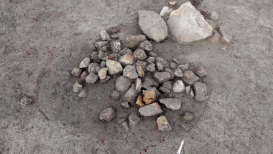
PATRIMOINE | Vestiges du premier âge du Fer au haut Moyen Âge à Entraigues-sur-la-Sorgue (Vaucluse) ➽ https://bit.ly/Vestiges-Entraigues-Vaucluse Préalablement au projet d’aménagement d’un centre pénitentiaire situé à la ZAC du Plan à Entraigues-sur-la-Sorgue, une équipe de l'Inrap a fouillé une superficie de 1,2 hectare et mis au jour des vestiges du premier âge du Fer ainsi qu’une occupation continue de l’Antiquité tardive au haut Moyen Âge
#archéologie#âge#Fer#Antiquité#MoyenÂge#EntraiguesSurLaSorgue#Vaucluse#archéologues#vestiges#archéologique#fouilles#Inrap
9 notes
·
View notes
Text
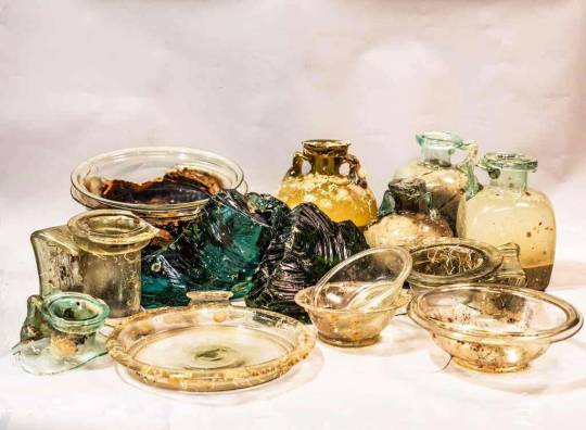
ARCHEOLOGIA / Straordinarie scoperte nel Mediterraneo: il relitto romano "Capo Corso 2" rivela il suo prezioso e imponente carico di vetro [FOTO / VIDEO]
ARCHEOLOGIA / Straordinarie scoperte nel Mediterraneo: il relitto romano "Capo Corso 2" rivela il suo prezioso e imponente carico di vetro (FOTO / VIDEO)
Testo da: Patrimonio Subacqueo
Si è svolta dal 1 all’8 luglio 2023 la prima campagna della “Missione italo-francese per lo studio del relitto profondo Capo Corso 2”. Il relitto, datato in via preliminare tra la fine del I e l’inizio del II secolo d.C., si trova a circa 350 metri di profondità nel tratto di mare fra Capo Corso (Corsica-Francia) e l’Isola di Capraia (Italia). Si tratta del secondo…
View On WordPress
#Antichità#archeologia#archeologia subacquea#Capraia#Corsica#Drassm#età romana#Inrap#naufragi#notizie#Patrimonio Subacqueo#relitti#Relitto Capo Corso 2#scavi#scavi archeologici#scoperte#Soprintendenza Nazionale per il patrimonio culturale subacqueo#vetro
5 notes
·
View notes
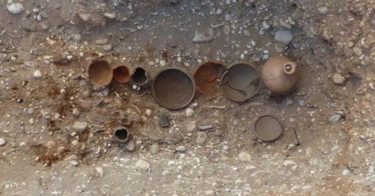
Photo

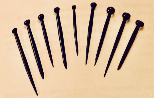

Epingles en ambre et en jais et bracelets en jais (IVe siècle) découverts par l'Inrap dans des sépultures à Saint-Pierre-L'Etrier près d'autun
4 notes
·
View notes
Text

Sprawling 2,000-Year Old Cemetery Discovered in France
In the middle of the first century B.C. — more than 2,000 years ago — scattered graves were dug next to a roadside in France.
For the next 600 years, what started as a few burials evolved into a sprawling cemetery filled with various types of graves and teeming with burial treasures. About 1,300 years ago, the site finally fell out of use, and its contents were left alone.
That is until now.
The development of a park near what is now the village of Saint-Vulbas led archaeologists to the discovery of the huge burial site in 2018, according to a Jan. 22 news release from the Institut national de recherches archéologiques préventives (INRAP). Since then, they’ve discovered more than 1,000 funerary structures — including 550 burials, 200 cremations, 30 funerary enclosures and 200 structures of an unknown nature.
After the initial burials, the cemetery, which was delimited by ditches and the road, became more densely populated toward the end of the first century B.C. and the start of the first century A.D., officials said.
The majority of these early burials belonged to toddlers. Archaeologists said they discovered 160 child graves. Most children were buried in a container made of wood or stone. Four children were cremated.
An area of pyre pits that was used through the second century was also found at the site, archaeologists said. Later, graves appeared closer to the edges of the site, marked by ditches, and were organized in rows.

Experts said they found evidence of both burials and cremations. Early on, burials were most common, but cremations became more popular between 60 A.D. and 100 A.D. before declining and mostly disappearing by the start of the fourth century A.D.
Cremated remains were usually found in single containers — such as a vase or box — but there were some double and triple containers, according to officials.
A variety of burial types were discovered at the site. Archaeologists unearthed some burials from the ground, but they also found covered pits and coffins.

Some burials were full of treasures, including an abundance of furniture and small vases, experts said.
Archaeologists found more furniture and grave deposits in child graves in early period burials at the cemetery.
However, the connection between age and burial treatment seemed to weaken over time. Ceramic objects and small pieces of furniture were found in later burials of all aged people.
A ditch at the site was also excavated, and researchers found a trove of cooking pots and jugs that might have been used to bring food and drinks for funeral meals or commemorations at the cemetery, officials said.
Saint-Vulbas is about 300 miles southeast of Paris.
By Moira Ritter.

#Sprawling 2000-Year Old Cemetery Discovered in France#village of Saint-Vulbas#ancient graves#ancient tombs#ancient artifacts#archeology#archeolgst#history#history news#ancient history#ancient culture#ancient civilizations
37 notes
·
View notes
Text

General view of the excavation of Notre-Dame Cathedral at the transept crossing (2022). The archeological discoveries made under the pavement revealed vestiges of remarkable scientific quality.
© Denis Gliksman
Iconothèque de l'Institut national de recherches archéologiques préventives (Inrap)
9 notes
·
View notes
Text
Découverte d’un “trésor” gaulois par des archéologues dans les Côtes d’Armor
Des archéologues ont mis au jour un “trésor” gaulois de 545 pièces de monnaie lors de fouilles sur le terrain d’une exploitation agricole de l’âge du Fer à Laniscat (Côtes d’Armor), a annoncé lundi l’Institut national de recherches archéologiques préventives (Inrap).
“La découverte de 545 monnaies est exceptionnelle par le nombre mais aussi parce qu’elle a été faite dans son contexte”, a commenté…
View On WordPress
2 notes
·
View notes
Text
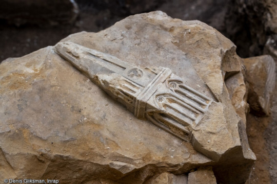
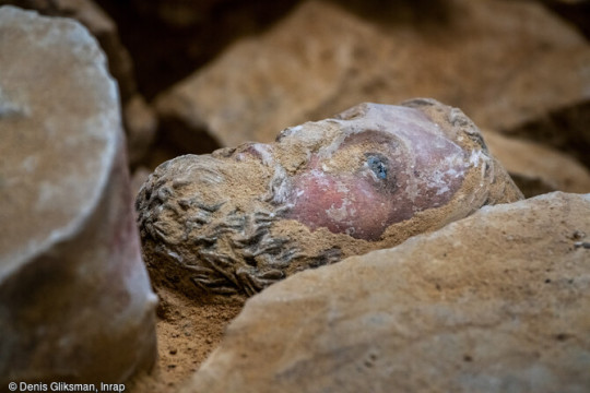
The remains of a set of Gallo-Roman buildings—including what might be a funerary monument—have been excavated in a residential district in Néris-les-Bains, a town in Auvergne, France. The tomb must have been a burial of a very important person to be so magnificently built.
Inside the discovery of 21 sandstone blocks—“a big surprise,” Marie-Laure Thierry, head of the operation at INRAP, told La Montagne. Once cleaned with water and a sponge, archaeologists found they were adorned with bas-reliefs that “have an unprecedented character for Néris-les-Bains, even for Auvergne,” added Thierry. There was a 27 inch relief of Triton a Sea God.
The town, best known for its thermal baths (its name derives from Nérios, Gallic god of the spring), was colonized
#history#archeology#archeologicalsite#discovery#greco roman#mausoleum#relief sculpture#roman art#roman architecture#france#king triton
2 notes
·
View notes
Text
Средневековый замок отыскался под французским отелем
Археологи из Национального института превентивных археологических исследований (Inrap) Франции провели раскопки на территории современного отеля в городе Ванн. В результате они обнаружили остатки средневекового замка.... Читать дальше »
0 notes
Text
descubren un sarcófago romano de 1.800 años de antigüedad en una necrópolis en francia
descubren un sarcófago romano de 1.800 años de antigüedad en una necrópolis en francia
Dos operarios supervisan las labores de levantamiento del sarcófago.Jean Jacques Bigot (INRAP)
la antigua ciudad romana de Durocortorum (Reims) fue la capital de la tribu de los remi (un pueblo belga que habitaba el noreste de la actual Francia en el siglo I a.C.) y que acabó por convertirse en la segunda ciudad más grande de la Galia romana. En su momento de máximo esplendor, Durocortorum…

View On WordPress
0 notes
Text
Figurine of Venus discovered in a Roman rubbish dump
A rare figurine of the goddess Venus was discovered by archaeologists from the National Institute for Preventive Archaeological Research (INRAP) while excavating a rubbish dump in the city of Rennes, France.
The figurine depicts a nude Venus, 10 centimeters high, made of terracotta. The deity is depicted holding her hair, adorned by a headdress. The researchers say that the piece could have been made between the 1st and 2nd centuries AD.
In the Roman pantheon, Venus is a goddess associated with love, beauty, desire, sex, fertility, prosperity and victory. According to this mythology, she was an ancestor of the Roman people through her son, Aeneas, who survived the fall of Troy and fled to Italy.
instagram
0 notes
Photo
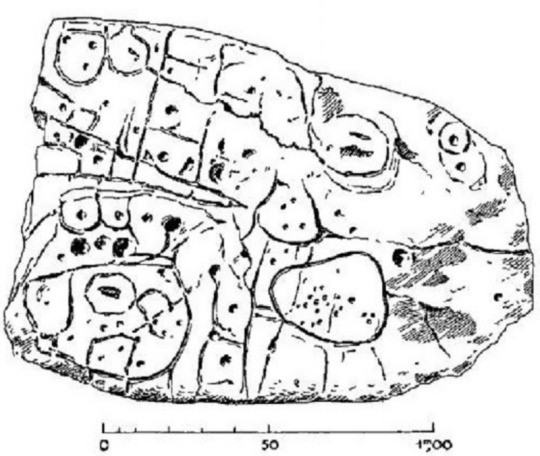
Europe’s Oldest Map Shows Tiny Bronze Age Kingdom
It’s about 4,000 years ago, and you are the ruler of a prosperous little Bronze Age kingdom at the end of the world. To celebrate your success, you commission a map of your bountiful domain: a stone slab 2.2 by 1.53 meters (6.5 by 5 feet), representing an area of 30 by 21 kilometers (19 by 13 miles). But all good things come to an end. You, or one of your successors, is buried with the slab—broken to indicate the overthrow of your dynasty. You have the last laugh, though. Your name and that of your little empire have been forgotten, but that slab is now recognized as Europe’s oldest map that can be matched to a territory—even if it took the supposedly clever scientists of the distant future more than a century to figure that out. In a nutshell, that is the story of the Saint-Bélec slab. In 1900, local archaeologist Paul du Châtellier retrieved it from a prehistoric burial mound in Finistère, the French department on the western edge of Brittany. (Its name means “end of the world.”) After unceremoniously gluing the pieces of the broken stone back together with concrete, Du Châtellier faithfully reproduced the markings on its surface for a report, in which he noted: “Some see a human form, others an animal one. Let’s not let our imagination get the better of us and let us wait for a Champollion [the Egyptologist who in 1822 deciphered the hieroglyphics, Ed.] to tell us what it says.” Du Châtellier had the stone, weighing more than a ton, moved to his ancestral home, Château de Kernuz, where he maintained a private museum. The slab was placed in a niche near the moat of the castle. After the amateur prehistorian’s death in 1911, his artifacts were acquired by France’s National Archeological Museum at Saint-Germain-en-Laye but remained on site. The stone languished in obscurity for decades. In 1994, researchers revisiting Du Châtellier’s original drawing found that the intricate markings on the stone looked a lot like a map. The stone itself, however, had gone missing. It was “rediscovered” in the castle cellar only in 2014. From 2017 to earlier this year, researchers from INRAP (France’s National Institute for Preventive Archaeological Research) and other institutions carried out extensive research on the slab. Their conclusion was published in March 2021 in the Bulletin de la Société préhistorique française. And it is spectacular: This is the earliest known example in Europe of a map for which we can identify the territory it depicts. The slab was engraved in the early Bronze Age (2150–1600 B.C.), which makes it contemporaneous with the Nebra Sky Disk, a map of the cosmos discovered in Germany (but not conclusively identified with any particular constellations). Another famous prehistoric map, from Bedolina in Valcamonica (northern Italy), is dated later, to the Iron Age. The landscape it depicts has not been identified; possibly it is a purely imagined one. The Saint-Bélec slab is the first map of its kind and age that has been identified with a particular territory. The researchers found that the markings on the slab corresponded to the landscape of the Odet Valley, oriented east-north-east to west-south-west. Using geolocation technology, the researchers established that the territory represented on the slab bears an 80 percent accurate resemblance to an area around a 29-kilometer (18-mile) stretch of the Odet River. The map is centered on the present-day municipality of Roudouallec, in the neighboring department of Morbihan, but also includes the location of the burial mound in which it was found, more to the west in Leuhan, as well as the foothills of the Montagnes noires (“Black Mountains”). The surface of the slab had been worked to represent the terrain’s undulations—also making it Europe’s oldest 3D map. Lines correspond to river tributaries. Various other markings (circles, squares) are thought to represent parcelled fields, settlements, and/or burial mounds and perhaps the ancient road from Tronoën to Trégueux. A circular symbol near the source of the Odet (and those of two other rivers, the Isole and the Stêr Laër) may represent the local ruler’s residence. The early Bronze Age was the time when the first primitive states emerged in western Europe and along with them a network of commercial, cultural, and diplomatic exchanges. This was an interconnected world, and the sea that surrounds Brittany on three sides was a passageway, not a border. In local Breton graves of that time, objects have been found that originated in southern England and northern Spain. The study speculates that the map might have been made as an expression of political power. But prestige need not have been the only reason. The map may also have served as a land register, to keep track of who did what where—and how much they owed in tax as a consequence. Whichever purpose it served, the slab may have been in use for centuries, before it was placed in a grave and broken in situ—perhaps a deliberate act of iconoclasm, to indicate the end of the unnamed Bronze Age kingdom. Perhaps the broken map is even an echo of a wider societal change: the end of the Bronze Age kings altogether. After all, it would not be France without the occasional revolution. The original article, La carte et le territoire : la dalle gravée du Bronze ancien de Saint-Bélec (Leuhan, Finistère), can be previewed and purchased from the Société Préhistorique Française. For more background, see this interview with researchers Yvan Pailler and Clément Nicolas at INRAP (in French). This article originally appeared on Big Think, home of the brightest minds and biggest ideas of all time. Sign up for Big Think’s newsletter.
https://www.atlasobscura.com/articles/europe-oldest-map-shows-tiny-bronze-age-kingdom
0 notes
Photo

PATRIMOINE | Archéologie d'un moulin à vent à Sartrouville (Yvelines) ➽ https://bit.ly/Fouilles-Moulin-Vent-Sartrouville Une équipe de l'Inrap fouille les fondations d'un moulin à vent et de la maison d'un meunier, un vestige rare d’une machine ayant pourtant joué un rôle prépondérant dans l’économie médiévale et moderne
#archéologie#moulin#vent#maison#meunier#économie#médiévale#moderne#Sartrouville#Yvelines#archéologues#vestiges#archéologique#fouilles#Inrap
4 notes
·
View notes
Text
ARCHEOSCOPERTE / A Parigi riemerge una vasta necropoli gallo-romanza: appartiene all'antica Lutezia
#ARCHEOLOGIA #SCOPERTE / A #Parigi riemerge una vasta #necropoli gallo-romanza: appartiene all'antica #Lutezia
Le sepolture, tutte a inumazione, datano al II secolo
𝐀𝐑𝐓𝐈𝐂𝐎𝐋𝐎 𝐂𝐎𝐌𝐏𝐋𝐄𝐓𝐎 di @Elenapercivaldi su @StorieArcheo
@InrapOfficiel
Gli archeologi dell’INRAP al lavoro sul sito di Port-Royal a Parigi. ©Cécile Olivier / INRAP
Una grande necropoli gallo-romana di circa 50 tombe, appartenenti a uno spazio funerario più vasto già noto dall’Ottocento, è tornata alla luce nel cuore di Parigi. Le sepolture, tutte a inumazione, datano al II secolo d.C. e appartengono a individui di età sia adulta che infantile. Al loro interno,…

View On WordPress
#archeologia#età romana#Francia#gallo-romani#In evidenza#Inrap#Lutezia#necropoli#notizie#Parigi#scavi#scavi archeologici#scoperte
2 notes
·
View notes
Photo


Impressionnantes fouilles archéologiques préventives de l'ancien Couvent des Capucins (1653-1789) orchestrées par l'Inrap - avant la construction du futur Conservatoire Intercommunal de Musique et de Danse - entre le bâtiment actuel du Centre Guéhenno construit initialement pour accueillir une école primaire (1881) et la petite maison restante habillée le temps d'un été par l'artiste de Street Art Yann Le Berre alias "L'Outsider" (2022), Quimperlé, Bretagne, France, juillet 2022.
1 note
·
View note
Text
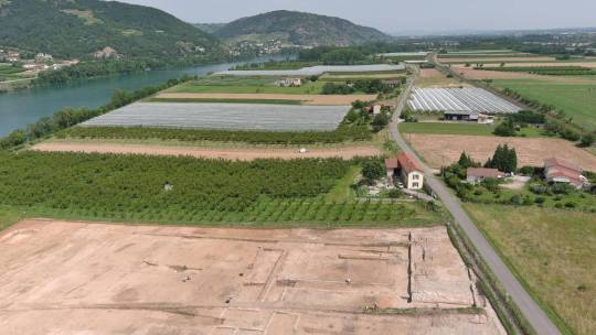
A 1,900-year-old Winery — That Made Drinks for Romans — Found in France
On the bank of a picturesque river in southern France sat a collection of ancient ruins. A buried cellar and empty pools are all that remain of a Roman-era winery.
Archaeologists found the ruined winery in Laveyron during excavations for a factory’s parking lot, the French National Institute for Preventive Archaeological Research (Inrap) said in a Nov. 30 news release.
The large-scale winemaking operation was built in the first century A.D. and probably produced drinks for ancient Romans, archaeologists said.
The Roman empire conquered modern-day France, then known as Gaul, in 53 B.C., according to Britannica. The region remained under primarily Roman rule until the early sixth century.
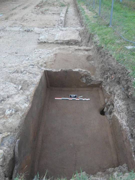
The 1,900-year-old winery had a central platform where the grapes were pressed, the release said. A photo shows this raised structure.

On either side of the platform, archaeologists found basins where the grape juice was collected. A photo shows one of these empty, rectangular basins.
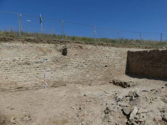
The basins were in turn linked to two larger rooms that archaeologists identified as cellars, the researchers said. A photo shows the cellar wall. A large section of the wall still stands. The construction appears to be made of neatly arranged, rectangular bricks.
Excavations also uncovered a three-room building that was likely used for the wine production, archaeologists said. The imprints of several large jars, typically used for storing wine or olive oil, were also uncovered. A photo shows these darker-brown, medium-sized imprints.

Archaeologists did not specify when or why the winery may have been abandoned.
The excavation also found traces of several older buildings, dating to the first century B.C., the institute said. The function of these remains unknown, but a nearby trash heap from the same period revealed fragments of pottery, including the large jars used for wine and olive oil.
Laveyron is along the Rhône river and about 300 miles southeast of Paris.
By Aspen Pflughoeft.


#A 1900-year-old Winery — That Made Drinks for Romans — Found in France#Laveyron#ancient artifacts#archeology#archeolgst#history#history news#ancient history#ancient culture#ancient civilizations#gaul#roman history#roman empire
25 notes
·
View notes
Last Seen Blogs

archieimagines
archie and all his friends

colloline
disappointment

antidotesprout
🔞Privately Owned Spiral Galaxy🔞

shanwoww
shooby

shireyishunjian
湿热一瞬间 / shireyishunjian - 众筹互免分享