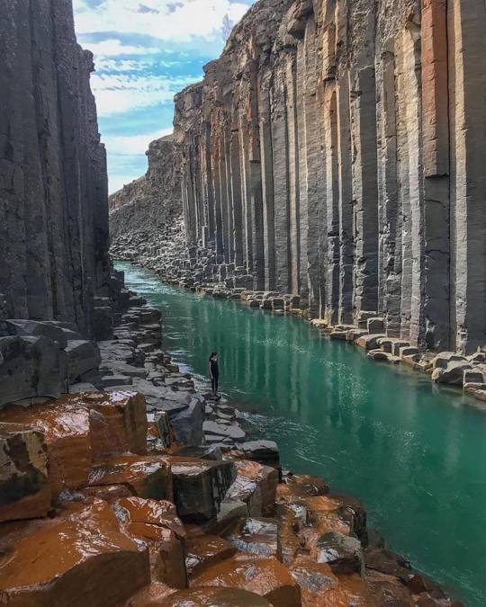
#Jökulsá
Photo

Jökulsá á Fjöllum river (at Iceland) https://www.instagram.com/p/ClwNKEfo60K/?igshid=NGJjMDIxMWI=
148 notes
·
View notes
Text


Skagafjörður (2) (3) (4) by Hugi Ólafsson
Via Flickr:
(1) The river Austari Jökulsá (Easternmore Glacial River) runs through a canyon for part of its course. The river has fostered a river rafting industry, with the rafting reputed to be among the best in Europe. The water is glacial melt, greyish to milky white. The cliffs are old basalt lava flows, with a vertical dyke bisecting the horizontal layers at one place.
(2) The farm Merkigil in the remote Austurdalur (Eastern Valley) in Skagafjörður in North Iceland. Below the farm houses is a canyon carved by a glacial river, which runs the entire valley. Despite this perilous setting, the valley was once populated with up to 20 farms. Merkigil was the last one to be abandoned, after the last inhabitant died in an accident in a nearby canyon in 1997.
(3) The inlet of Staðarbjargavík (Town Cliffs' Inlet), by the village of Hofsós in Skagafjörður in N-Iceland, well known for crops of well-formed columnar basalt.
(4) The old turf farm and museum at Glaumbær in N-Iceland. Turf housing was the universal vernacular type of architecture in Iceland for most of its history, resulting from the fact that the country has little wood and usable building stone, but in most places plenty of turf and peat. When abandoned, the houses would almost naturally melt into the countryside. This lack of durability, and the fact that turf houses became a symbol of poverty and backwardness for Icelanders in the 20th Century, has resulted in a limited number of well preserved turf houses today.
#rivers#cliffs#farm#inlet#rock formations#museum#turf roof#traditional house#iceland#northwestern region (iceland)#skagafjörður
0 notes
Text
Cañón basáltico de Studlagil, en Islandia
En el valle Jökuldalur, en la zona este de Islandia, el río Jökulsá á Dal se abre paso entre las paredes con columnas de basalto del cañón Studlagil hoy perfectamente visibles. Sin embargo, no siempre ha sido así.
No fue hasta el año 2007 cuando la construcción de la presa Kárahnjúkar disminuyó tanto el caudal del río que dejó a las vista las columnatas basálticas que hoy podemos ver en el cañón Studlagil de Islandia.
0 notes
Text
Karl og Kerling - two petrified trolls in Iceland
According to the legend, in northern Iceland, two petrified trolls stand guard over an ancient canyon.
Created by the river Jökulsá á Fjöllum, which carved out the whole canyon that surrounds the unusual stone outcroppings, these two stones are called “Karl og Kerling”, a name literally translates to “husband and wife.”
The pair of stones stands near the mouth of the biggest cave in the canyon,…

View On WordPress
#Europe#folklore#human#iceland#international#legends#local history#nature#news#oddities#people#stories#Travel#world
1 note
·
View note
Photo

Sleipnir’s footprint
The canyon of Ásbyrgi is a horseshoe shaped depression of 3.5 km long and 1 km wide that formed during numerous jökulhlaups of the Jökulsá river. Jökulhlaups occur when a volcano under the massive Vatnajökull glacier heats up and melts the ice that lies on top of it. Tephrachronology, the dating of tephra (any volcanic material ranging fom ash to volcanic blocks) depositions of volcanic eruptions places the last of these flooding events around 2500 year ago, during an eruption of Hekla. The canyon is located in the north of Iceland, about 50km from the harbor town of Húsavík and close to the southeast corner of Vatnajökull glacier.
The 100m high cliffs formed from lava erupted out of Stóravíti crater, part of one of the largest lava shields on Iceland. This volcanic system is called Þeistareykjabunga and lies north of Lake Mývatn. The last eruption at Stóravíti started around 12,000 year ago and could have lasted decades. Eventually, the lava spread over an area of 525 km2 which is a little bit less than the city of Madrid. In the centre of the canyon a 25m high rock formation, known as Eyjan (Icelandic: island) arises and offers spectacular views over the canyon. Also, the area within the canyon is stacked with trees as mountain ashes, birch and willow of which some can grow up to 8m in height. Having trees grow this high is quite uncommon for Iceland.
However, according to Norse legends, Ásbyrgi canyon formed in a slightly different manner than that mentioned above. When Norse god Óðinn’s horse Sleipnir (Icelandic: Slættur) touched his hoof to the ground at Ásbyrgi, he left a horseshoe-shaped footprint in place. Thus, the canyon is also known as ‘Sleipnir’s footprint’. Supposedly, the huldufólk (elves or hidden people) live in the cracks of the cliffs.
-OW-
Image: Andreas Tille. The inside of Ásbyrgi as seen from the top of Eyjan.
Further reading: http://www.diamondringroad.com/asbyrgi.html http://www.geothermal.is/3-asbyrgi http://www.volcano.si.edu/volcano.cfm?vn=373090
#Ásbyrgi#erosion#canyon#geology#jökulhlaups#jökulhlaup#Jökulsá#Vatnajökull#Iceland#nature#odin#sleipnir#Slættur#footprint#myth#mythology#the earth story
144 notes
·
View notes
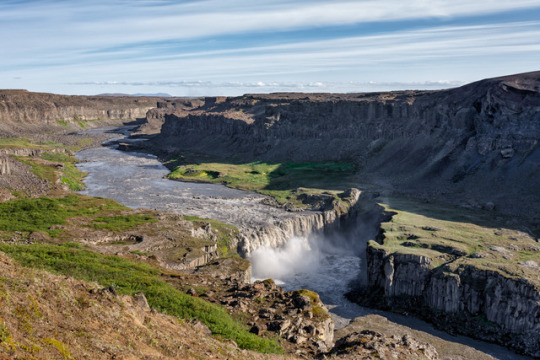
Photo

“Jökulsárgljúfur”
Jökulsá gorge between Hafragilsfoss and Réttarfoss in the East of Iceland
144 notes
·
View notes
Text
Island 2021 - Tag 10 Teil 2
Herrschaften!
Nach unserem kleinen Picknick machen wir uns auf den Weg nach Borgarfjördur Eystri.

Eigentlich nur eineinhalb Fjorde in nördlicher Richtung entfernt, müssen wir rund 80 Kilometer weit fahren, weil Berge und Wasser im Weg sind.

Die Hochebene Fjardarheidi zeigt sich von ihrer besten Seite, wir parken in einer Haltebucht und fotografieren die stille, einsame Landschaft mit fischreichen Seen und fantastischen Farben.

Der Osten des Landes verfügt nicht über die üppige Vielzahl an Sehenswürdigkeiten, mit denen zum Beispiel die Südküste gesegnet ist.

Doch eine herrliche Küste, charmante Dörfer, der größte Wald Islands und Rentierherden, es ist eine Landschaft wie aus dem Bilderbuch, ein Eldorado für Wanderer und Naturliebhaber.

Am Ende des Jökulsá á Brú biegen wir rechts auf die 944 ab. Am Lagarfossvirkjun legen wir einen Fotostopp ein.

Im Jahr 1974 wurde hier ein Wasserkraftwerk mit einer installierten Leistung von 8 MW errichtet. Es dient zur lokalen Energieversorgung. Der Wasserfall war dadurch oft verschwunden.

Das Kraftwerk wurde 2007 um 20 MW erweitert. Seit der Inbetriebnahme des Kárahnjúkar-Kraftwerk im Jahr 2007, bei dem zusätzliches Wasser in das Lagarfljót geleitet wird, ist der Wasserfall wieder sichtbar.

Wir folgen der 944 bis wir auf die 94 treffen, die in ihrem Verlauf zu dem Fischerort Borgarfjördur führt.

Die Strecke nach Borgarfjördur, mittlerweile durchgehend asphaltiert, ist eine eindrucksvolle Berg- und Talfahrt.

Immer wieder halten wir an, es geht einfach nicht anders, und die Sonne spielt auch mit.

Noch spielt die Sonne mit - das sollte sich aber in dem Ort Borgarfjördur total ändern.

Die alte, stillgelegte Fischfabrik ist in dem dichten Nebel, der inzwischen aufgezogen ist, kaum auszumachen.

Wir bewundern dennoch die alten historischen Häuser aus der Jahrhundertwende ...

... irgendwie scheint hier alles ein wenig aus der Zeit gefallen.

Wir biegen ab, fahren über eine spektakuläre Küstenstraße und nun geht es immer tiefer in den Fjord hinein.

Wir fahren bis zum kleinen Hafen Hafnarholmi, wo die Straße 94 endet. Wir sind angekommen! Der Nebel hat den Ort glücklicherweise noch nicht erreicht.

Achtung! Auch hier gibt es einige touristische Neuigkeiten: es darf nicht mehr bis zum Hafen runter gefahren werden.

Ein funkelnagelneuer Parkplatz wurde für die Besucher oberhalb eingerichtet.

Und es gibt ein nigelnagelneues Restaurant.

Rund 10.000 Puffin-Paare nisten hier im Sommer, auf der kleinen Halbinsel hinter der Marina.

Eigentlich hatten wir hier richtig Vogelgekreische und Lärm erwartet, doch es war relativ ruhig.

Zuerst sehen und hören wir nur Möwen.

Die füttern zur Zeit noch ihre Jungen.

Treppen und Plattformen schützen die Landschaft und die Tiere, das wirkt auf den ersten Blick vielleicht nicht attraktiv, ergibt aber Sinn.

Richtig beunruhigt sind wir, als uns deutsche Touristen entgegen kommen und sich darüber beklagen keine Puffins mehr gesehen zu haben.

Sie wären wohl um ein paar Tage zu spät dran.

Ach herrje, der ganze Weg umsonst...

Doch halt, was flattert denn da?

Ein paar Nachzügler gibt es noch, die zu ihren Nestern fliegen und Futter heran schaffen:

Die Flügel der Vögel sind insgesamt ein wenig mickrig geraten, bei der Landung fallen die kleinen Bruchpiloten fast wie ein Stein vom Himmel.

Dazu der tollpatschige Gang, doch der Schein trügt: Im Wasser sind Papageitaucher nicht nur geschickte Schwimmer, sondern auch begnadete Fischer.

Lange beobachten wir das Treiben...

Auf dem Meer wird schon der Nachwuchs unterrichtet, der bereits flügge ist:

Die Papageitaucher verbringen nur die kurze Brutzeit an Land, den Rest des Jahres leben sie auf dem offenen Meer.

Wir haben vieles richtig gemacht an diesem herrlichen Tag. Das wissen wir spätestens, als wir durch den dicken Nebel zu unserem “Spar-Cottage” zurückkehren.

Gute Zeiten, schlechte Zeiten, Sonne und Wolken - dazwischen liegt auf Island manchmal nur ein einziger Fjord.
Gute Nacht!
Angie, Micha und der Hasenbär
17 notes
·
View notes
Text
شلال Dettifoss
من أقوى الشلالات في أوروبا، شلال Dettifoss. متوسط عبور المياه يصل إلى 500 متر مكعب في الثانية.
شلال Dettifoss هو شلال في متنزه Vatnajökull الوطني في شمال شرق أيسلندا، ويشتهر بأنه ثاني أقوى شلال في أوروبا بعد شلالات الراين. يقع Dettifoss على نهر Jökulsá á Fjöllum ، الذي يتدفق من نهر فاتناوكول الجليدي ويقوم بجمع المياه من منطقة كبيرة في شمال شرق أيسلندا. يلون الجريان الغني بالرواسب المياه بلون أبيض رمادي.
9 notes
·
View notes

Photo

Dettifoss Waterfall in Iceland 🌊 by eyeshotHQ
See 360° View
Dettifoss is a waterfall in Vatnajökull National Park in Northeast Iceland and is reputed to be the second most powerful waterfall in Europe after the Rhine Falls. Dettifoss is situated on the Jökulsá á Fjöllum river, which flows from the Vatnajökull glacier and collects water from a large area in Northeast Iceland. The sediment-rich runoff colors the water a greyish white.
1 note
·
View note
Photo

As we were driving over Mývatnsöræfi today we saw a large herd of Reindeers. The Reindeers were imported to Iceland for experimental purposes in the 18th century, the purpose was to build up a stock for the Icelandic agriculture to use in the same way as in Lapland. Cold weather, harsh winter and limited food supply made it difficult for the reindeers in Iceland and most of them died. In the year 1939 it was believed that the reindeers were almost extinct in Iceland, but after searching for a while around 100 reindeers were found in East Iceland, it is believed that the current stock is their descendants. In the following years the stock grew rapidly and today around 6000-7000 reindeers can be found during the summer in Iceland but only in the eastern part of the country, east of Jökulsá á Fjöllum river and north of Vatnajökull glacier. #iceland #reindeers #northeasticeland #phototour #blue #winter #cold #sonyalpha #mystopover #stayandwander #ig_iceland #wanderlust #doyoutravel https://www.instagram.com/p/B8J8WjTAqm4/?igshid=wazewxjse08y
#iceland#reindeers#northeasticeland#phototour#blue#winter#cold#sonyalpha#mystopover#stayandwander#ig_iceland#wanderlust#doyoutravel
3 notes
·
View notes
Photo

armxesde
0 notes
Photo

Jökulsárlón, Iceland by mpsmarcopolo
#landscape#lake#sea#sunset#mountains#water#travel#light#clouds#rocks#snow#ice#iceberg#Iceland#Jökulsá
0 notes
Photo

Cañón de Ásbyrgi, Islandia 📍🇮🇸 comenzó a formarse hace aproximadamente ocho o diez millones de años⌛, justo después de la última Edad de Hielo 🌨️🌬️, luego de una catastrófica inundación glacial del río Jökulsá á Fjöllum. Esta inundación probablemente ocurrió debido a una erupción volcánica debajo del casquete glaciar, el glaciar Vatnajökull. Más tarde, hace solo 3000 años, este proceso se repitió, esculpiendo aún más el espectacular desfiladero que conocemos y amamos hoy. 📸: @iuriebelegurschi . . . Ásbyrgi canyon, Iceland 📍🇮🇸 began to form about eight or ten million years ago⌛, just after the last Ice Age 🌨️🌬️, after a catastrophic glacial flood from the Jökulsá river to Fjöllum. This flood probably occurred due to a volcanic eruption below the ice cap, the Vatnajökull Glacier. Later, only 3000 years ago, this process was repeated, sculpting even more the spectacular gorge that we know and love today. 📸: @iuriebelegurschi . . . #iceland #islandia #nature #travel #landscape #travelphotography #ig #trip #wanderlust #photography #travelgram #islandiadesigns #icelandtrip #adventure #icelandair #islandiafototrip #naturephotography #igeologia #geology #geologia #geología (en Asbyrgi Canyon) https://www.instagram.com/p/BwflU-2JCml/?utm_source=ig_tumblr_share&igshid=16gxyaxp7vs2l
#iceland#islandia#nature#travel#landscape#travelphotography#ig#trip#wanderlust#photography#travelgram#islandiadesigns#icelandtrip#adventure#icelandair#islandiafototrip#naturephotography#igeologia#geology#geologia#geología
6 notes
·
View notes
Text
Droning in Iceland
Aerial views of Iceland, September 2021: Skútafoss, Sveinsstekksfoss, Hvannagil and the surrounding area, Jökulsá á Fjöllum, a stop off in the Akrahreppur region in Northwest Iceland, the Skútustaðagígar Pseudocraters, Hverfjall Volcano Crater and surrounding area.
All drone footage: @greg_inda Edit/Color: @itslindseymarks
#iceland #icelandtravel #aerialphotography #dronevideo
--
My partner Lindsey and I have talked a lot about fitting drones into my arsenal. How best to utilize aerial work while being cognizant of the ethics and how not to be a nuisance traveler. Below are some thoughts that Lindsey shared on Facebook, as well as some of my follow up and her follow up to my follow up.
Lindsey: I'm really happy about how we approached getting the drone out on this trip. Greg is a thoughtful person and did his research, and I've redirected my "need-to-fix-my-anxiety problem" reactions when people I'm with are using drones to owning my thoughts as entirely reasonable personal stances. In Iceland we were fortunate to find areas that were extremely unpopulated and under trafficked. Some of these areas are publicly accessible but aren't really even tourist destinations. Some we were the only people in sight. There are areas that do not allow drones without a permit, but many main tourist attractions are drone-able...so it's on you to make decisions. We weren't 100% perfect, but I think we avoided disturbing people really effectively and I love what Greg got! Deepening that as a skill set would be pretty awesome and he's looking into the licensing process.
Greg: It really gets to be a complex ethical dilemma. Droning offers such an interesting perspective on the world. And as a photographer I constantly feel the desire to be elevated by about 10 feet. I remember reading about an Ansel Adams photograph, and he talked about standing on top of his van to get a slightly different perspective on some boulders (I'll try to find a link), and that story ALWAYS had me wishing for a car I could stand on top of. Or a moonroof. Or... a drone! It really is a visual game changer.
And then you read about drones landing in migratory bird nesting sites causing untold damage. Or someone using a drone to spy on a neighbor. And the whole notion just becomes awful.
And there is definitely a cyclical oneupmanship that happens. It's like when the selfie stick dropped and everyone got one.
One pull that I started feeling as we were droning in Iceland, and I guess something I've felt even droning here around the farm, is the need to share the experience. Share the literal experience of droning. Not hiding off in a corner trying not to be seen, but to share it. Show people in the moment what you're seeing. Even letting someone tell you where to go. Because then it shifts from a literal annoyance into something that multiple people can enjoy. Though I also felt the need to hide in a corner sometimes too. I felt both things.
As I progress down the path of licensed drone pilot, it'll be a lot to think about and consider.
Lindsey: That's an interesting perspective too, down there at the end on sharing! I did notice you had some people who were interested in and a bit excited about what you were doing, same when we were in Kentucky...and being closer in your launch point in those instances made it possible for them to approach you without being weird and feeling rude about encroaching on your space. I wonder if some of the nuance is being at say...a trail head "heading towards the thing"...vs. the endpoint where all focus is on the thing? Probably all just depends.
Hiding kind of gets to my "get over anxiety" bit. And I think that's a take up space issue that might not leave as much room for thinking about the positive interactions people have with other people using drones.
If I think about it really...part of my critique stems from, as a spectator in an area, I don't like drones being around, particularly because of the sound, which I find to be hyper grating and a little scary. Even with no one around.
Greg: I think its hard not to be totally annoyed by the sound. And in serene, remote places, sound is such a huge part of the experience. It's selfish to take that away from someone just because you have a drone and want to fly it.
But I'm sure that conversation will evolve and shift as they start to make totally silent drones... which will lead to other types of problems.
Or maybe they go the other way and add a boom box function to drones, or a megaphone. Drones flying overhead adding a sound track to your nature experience.
0 notes
Photo
“Hafragilsfoss”
Waterfall near the better known Dettifoss waterfall in the East of Iceland
130 notes
·
View notes
Last Seen Blogs
vydumaj
Свяці

fakejanicecombs-blog
The Secret Diaries of Janice Combs

vistadent-hyd
Orthodontist In Hyderabad| VistaDent

cocotesempal
Untitled

myersquats
YOUR ONE DESIRE