#Laurisilva Forest
Text
“Green Machine: Twister”
View On WordPress
#cone#Fanal#funnel#green#green machine#Laurel Forest#Laurisilva Forest#Madeira#Portugal#trees#twisted#twister
2 notes
·
View notes
Text
#carmen nuñez#woman photographer on tumblr#monte las mercedes#cruz del carmen#tenerife#canary islands#forest#landscape#iphone#monteverde#laurisilva#nature
37 notes
·
View notes
Text

#mis fotos#amanecer#sunset#sunset colors#forestal#gran canaria forestal#naturaleza canaria#forestales gran canaria#reforestación#montes de gran canaria#cumbres de gran canaria#laurisilva#bosque termófilo#macaronesia#islas canarias#conservación medio natural#arboles#paisajes de gran canaria#pueblos de gran canaria#beautiful places#awesome places#naturaleza#nature#paisaje rural gran canaria#paisaje rural#country landscapes
1 note
·
View note
Text

When owls find their way onto isolated islands lacking any terrestrial predators, they have a tendency to take up that role for themselves – evolving longer legs and shorter wings, and specializing more towards hunting on foot. From New Zealand to Hawaii to the Caribbean to the Mediterranean to Macaronesia, leggy island ground-owls have independently happened over and over again in the last few million years—
—And, unfortunately, they've all also become victims of the Holocene extinction, their fragile island ecosystems too easily disrupted by human activity and the arrival of invasive species.
The São Miguel scops owl (Otus frutuosoi) was found only in the Azores on São Miguel Island. About 18cm tall (~7"), it was slightly smaller than its relative the Eurasian scops owl, with longer legs, a wider body, and much shorter wings.
Its wing proportions indicate it would have been a poor flyer, instead primarily hunting on foot in the dense laurisilva forests. Since there were no terrestrial mammals or reptiles on São Miguel at the time, its diet probably mainly consisted of insects and other invertebrates – and it would have in turn been the potential prey of larger predatory birds like buzzards and long-eared owls.
All currently known subfossil remains of the São Miguel scops owl date only from the Holocene, between about 50 BCE and 125 CE. It's likely that it was extinct by the 1400s, following the settlement of humans in the Azores, destruction of its forest habitat, and the introduction of rodents, cats, and weasels.
———
NixIllustration.com | Tumblr | Twitter | Patreon
#science illustration#paleontology#paleoart#palaeoblr#são miguel scops owl#otus frutuosoi#strigidae#true owl#strigiformes#owl#bird#dinosaur#art#azores#convergent evolution#a superb owl
698 notes
·
View notes
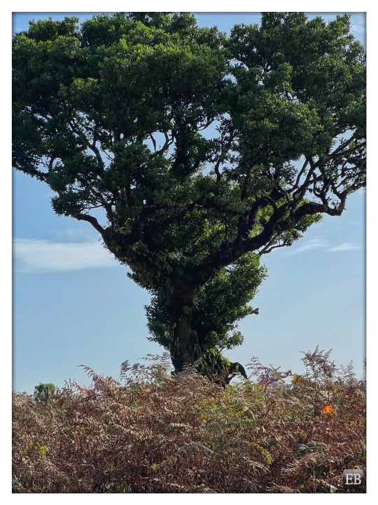
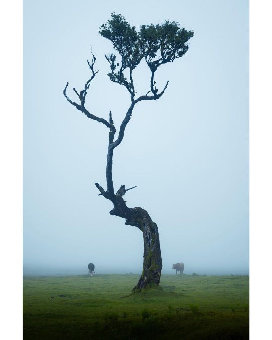
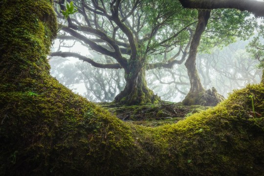
Text

Ancient trees of the Fanal in Madeira. Fanal is part of the Laurisilva forest which is also a UNESCO World Heritage site. Some of these trees are 500 years old.
Photography Joni Niemelä
44 notes
·
View notes
Photo
Laurisilva of Madeira 👌🏼 Best known as the Fanal Forest, this is such a unique place to explore! The forest is a UNESCO world heritage site and seeing this unusual landscape in person it’s easy to see why! These unusual trees covered large parts of Europe but they’re now found in only a handful of locations.. Madeira being one of them! Such an eerie place to visit when the fog is rolling through! Have you been here? • • #madeira #fanalforest #portugal #moody #mood #fog #eeriebeautiful #vivacmagazine #moodygrams #photography #opticalwander #discoverunder5k #madeiraisland #visitmadeira #madeiralovers #travelphotography #photooftheday #sonyshooter #ukshooters #tamron2875 #tamron #sonyalpha #a7riii #foggy #landscape #moodytoning (at Fanal) https://www.instagram.com/p/CpCanqID21E/?igshid=NGJjMDIxMWI=
#madeira#fanalforest#portugal#moody#mood#fog#eeriebeautiful#vivacmagazine#moodygrams#photography#opticalwander#discoverunder5k#madeiraisland#visitmadeira#madeiralovers#travelphotography#photooftheday#sonyshooter#ukshooters#tamron2875#tamron#sonyalpha#a7riii#foggy#landscape#moodytoning
179 notes
·
View notes
Photo
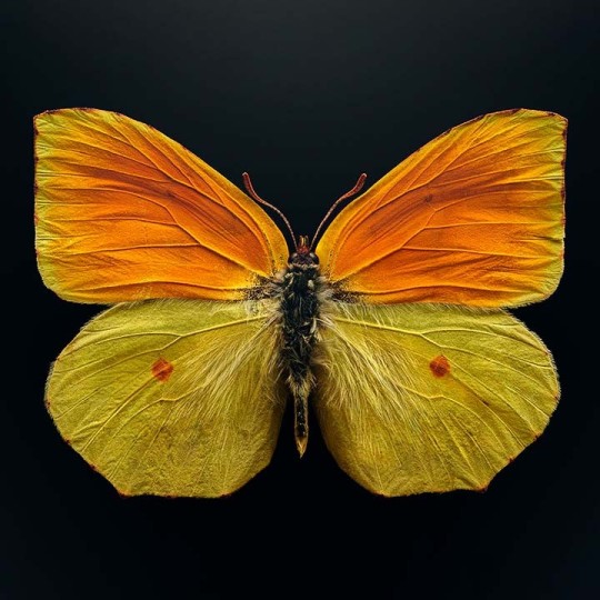
🦋Where does the Madeira brimstone (Gonepteryx maderensis) get its common name? Its fiery yellow hues match those of the element sulfur, once known as brimstone! ⛰️This butterfly lives in the steep mountains of the Madeira islands, where it spends much of its time high in the canopy of evergreen laurel forests, called laurisilva. Unfortunately, it’s endangered due in part to urban development that has led to habitat loss. The life cycle of Madeira brimstones naturally limits their population growth: adults can live for several months—a long time for a butterfly—and there is likely only one new generation each year. What’s more? Their caterpillars feed on just one type of tree. But there may be a bit of protection: Madeira has a vast nature preserve, and remaining laurisilva areas are now officially protected in a UNESCO World Heritage Site. 📸The Museum's upcoming special exhibition Extinct and Endangered: Insects in Peril, opens on June 22 and will feature uniquely powerful macrophotography by Levon Biss (@levonbiss) highlighting 40 incredible but imperiled species from specimens in the Museum's world-class research collection, including the Madeira brimstone, in large-format photographs, some as large as 4.5 by 8 feet. Link in bio for more details! Photo: © Levon Biss #AnimalFacts #EndangeredSpecies #insects #bugs #butterflies #Madeira #MadeiraBrimstone #museums #amnh #dyk (at American Museum of Natural History) https://www.instagram.com/p/CelhKWVroyZ/?igshid=NGJjMDIxMWI=
354 notes
·
View notes
Text
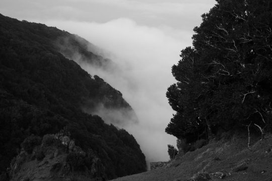
As summer fires continue to devastate huge areas of woodland in Spain, France and Portugal, and drought plagues Europe and the UK leaving tens of thousands of acres at risk of desertification, some scientists are busy collecting fog.
The EU-backed Life Nieblas project (niebla is Spanish for fog) is using fog collectors in Gran Canaria in Spain’s Canary Islands, and Portugal, to improve degraded landscape and fuel reforestation.
Fog collectors – sheets of plastic mesh erected in the path of the wind – already exist but have never been used efficiently, says Vicenç Carabassa, the project’s head scientist, who works for the Centre for Ecological Research and Forestry Applications (Creaf), a public research institute at the Autonomous University of Barcelona. As wind blows fog through the mesh, water droplets collect and fall into the containers below.
Fog collection is particularly applicable in restoring the Canary Islands’ laurisilva [laurel forests], which themselves exist by collecting fog water,” says Carabassa. The water droplets from the fog condense on the trees’ shiny, waxy leaves. “The system allows saplings to flourish until they are mature enough to capture water themselves,” he adds. Laurisilva is sub-tropical rainforest populated by evergreen species, though not necessarily the familiar laurel trees found in parks and gardens.
To operate well, fog collectors need both fog and wind, conditions that exist in the Canaries and Portugal, but less so in the Mediterranean, where forest fires and desertification are a growing problem.
“We’re still trying to discover what are the optimal conditions for fog collectors to work,” says Carabassa, who adds that laurisilva restoration can help to replenish the aquifers that are under constant strain in the Canaries.
As well as the Canary Islands, where Creaf is working with the Gran Canaria local authority, the public company Gesplan, which manages the project, and several other research institutes and public organisations, the technique will be tested in maritime areas around Barcelona and the El Bruc municipality in northern Catalonia, which was ravaged by a huge fire in 2015.
#fog#fog collection#water scarcity#drought#canary islands#Portugal#laurel forests#desertification#Mediterranean#wildfires
8 notes
·
View notes
Text
Closs Island
A lush warm tropical island, with white sandy beaches and thick verdant vegetation. Notable for the landmark of Neptune’s Gate on its southwest coast.
The interior of Closs Island is mostly laurisilva forests and is a protected biozone. It is sparsely populated and heavily protected by law to prevent over-development.
It is one of the Cockayne Islands, along with Little Meteor Island and Cable…
View On WordPress
0 notes
Photo

Lagoa das Sete Cidades (Lagoon of the Seven Cities) in Sete Cidades, Portugal
Jacob and Esau. Apollo and Artemis. Mary Kate and Ashley. People have always been fascinated with twins, and these twin lakes are no less interesting. In a 22,000-year-old (at least) volcanic crater on the island of São Miguel in the Azores archipelago of Portugal, you’ll find the blue and green lakes of Sete Cidades. While technically one body of water, the lagoon appears like two separate lakes—Lagoa Azul (Blue Lake) and Lagoa Verde (Green Lake)—nearly separated by a narrow stretch of land with a bridge. The water is surrounded by a lush landscape of ancient subtropical forest, laurisilva (laurel forest), and blue hydrangea. The twin lakes are often cited as one of Portugal’s seven natural wonders, and for good reason. While ecologically separate, they comprise the largest body of water in the Azorean archipelago and are an important freshwater source for the region. And their folklore is even more captivating. Legend has it that a noble princess and a lowly shepherd fell in love, and their romantic liaisons took place in the hills over Sete Cidades where they could meet under the stars. The king discovered the clandestine lovers and forbade them to meet, as kings often do. The young princess had emerald green eyes, and the shepherd boy’s eyes were hydrangea blue. When their romance was dashed they each cried a lake of tears, one green and one blue. While science has proven the lakes to be a single body of water that simply reflects sunlight in two different colors, it’s a beautiful destination that easily conveys romantic fairy tales past and present. Don’t miss the King’s viewpoint—King Carlos I, not the mean father of yore—where the Portuguese ruler and his wife, Queen Amelia, stood during their visit in 1901 and declared it the most beautiful spot in the Azores.
https://www.atlasobscura.com/places/sete-cidades-twin-lakes-of-the-azores
0 notes
Text
Teror

Descripción del municipio
La Villa de Teror es un municipio no costero situado en el norte de la isla de Gran Canaria, que cuenta con una superficie de 25,70 km².
El municipio de Teror es uno de los más antiguos y más poblados de las Islas Canarias. La historia de Teror se remonta a la aparición de la Virgen del Pino en 1481. Desde entonces, Teror ha sido considerada como Villa Mariana, capital religiosa, ya que es el hogar de la patrona de Gran Canaria. La zona próxima a la basílica está declarada patrimonio histórico-artístico y allí pueden contemplarse varios ejemplos de arquitectura tradional y de mansiones señoriales como la Casa de Los Patronos de la Virgen.
Además de porque aquí hallamos la Basílica de Nuestra Señora del Pino, la tradición religiosa de Teror se hace patente por la ubicación en su término municipal de dos conventos de clausura, el Convento del Císter, famoso por sus dulces artesanales, y el Convento de las Madres Dominicas.
Resultan apreciadas por sus saludables características las aguas minerales que manan de la Fuente Agria, manantial público del que se surten gratuitamente los lugareños y cuyas aguas son envasadas por el propio ayuntamiento para su distribución a todas las islas.
Teror cuenta con varios parajes naturales de notable interés, como el Parque Rural de Doramas, donde se emplaza la Finca de Osorio, tierras de mayorazgo que, además de contar con una gran riqueza forestal, fueron aprovechadas para el cultivo de millo, papas, trigo y frutales. En torno a una gran casa señorial de 1.000 m², con un bello jardín de corte romático, la finca se extiende hasta abarcar una superficie de 207 hectáreas, conservándose en su interior restos de bosques de laurisilva y una amplia extensión cubierta por frondosos castañeros, todo ello surcado por una extensa red de caminos y senderos que culminan en el alto del Pico de Osorio, desde donde se contempla toda la finca y una bella panorámica del centro-norte de Gran Canaria.
Más información
Símbolos de Teror
Bandera
La bandera de Teror está formada por cinco franjas horizontales, siendo la superior e inferior de color verde y de una anchura de un 22,5 % del ancho total del paño, la central blanca, de un 40 % del ancho, y separadas entre sí por dos franjas amarillas cuya anchura corresponde al 7,5 %.
El verde representa la abundante vegetación del municipio, además de ser un color tradicionalmente identificado con Teror por sus habitantes, que lo suelen usar en manifestaciones culturales, deportivas, etc. El amarillo aparece tanto en la bandera de la isla como en la de Canarias, y además es el color característico de la piedra de cantería de Teror, usada en construcciones como la Torre Amarilla de la Basílica de la Virgen del Pino. El blanco también está presente en la bandera canaria, así como en la arquitectura popular y tradicional del municipio.
Aprobación: Orden Consejería de Presidencia, Justicia y Seguridad del Gobierno de Canarias de 6 de agosto de 2007 (BOC de 14 de agosto).
Escudo heráldico
El escudo de Teror fue aprobado por Acuerdo del Consejo de Ministros de 25 de febrero de 1955 (pubicado en el BOE de 7 de marzo de 1955).
Escudo cuartelado. Primero, de gules, castillo en su color. Segundo, de oro, león de gules. Tercero, de azur, torre en su color terrazada de gules, acompañada de dos palmeras resaltada cada una de un perro. Cuarto, medio partido y cortado, primero, de azur, lucero de plata; segundo, de sinople, pozo al natural; y tercero, de gules, castillo al natural, con una cinta de plata al pie con la leyenda “Malo Mori Quam Foedari”. Escusón de plata con un pino al natural cargado de anagrama mariano de plata. Al timbre, corona real abierta. Al pie, cinta de oro con la leyenda “Ave María”.
Los dos primeros cuarteles representan a España, el tercero a Gran Canaria y el cuarto a la familia Pérez de Villanueva, fundadores de la villa de Teror y primeros patronos del santuario de la Virgen del Pino, patrona de Gran Canaria, a la que simboliza el escusón.
0 notes
Text
Madeira: Skywalk, Porto Moniz Volcanic Pools, and Fanal Tour GetYourGuide
Madeira: Skywalk, Porto Moniz Volcanic Pools, and Fanal Tour GetYourGuide
Madeira: Skywalk, Porto Moniz Volcanic Pools, and Fanal Tour USD 59.55. Swim in the natural volcanic pools at Porto Moniz, visit one of Portugal’s 7 wonders the Fanal Laurisilva forest, see beautiful waterfalls, enjoy the biggest plateau at Paul da Serra and the highest Sea Cliff of Europe at 589 mts. with its glass floor..
Review the Madeira: Skywalk, Porto Moniz Volcanic Pools, and Fanal Tour…

View On WordPress
0 notes
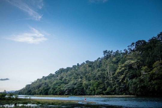
Photo

Enchanting Photos of Madeira’s Ancient Fanal Forest Filled With 500-Year-Old Trees - Portugal
Fanal is part of the Laurisilva forest, a UNESCO World Heritage Site known for its beauty and ecological importance. Incredibly, 15 to 40 million years ago, much of Southern Europe was covered in this type of laurel forest. Now, it can only be found in Madeira, the Azores, and the Canary Islands.
Photographer: Albert Dros


#albert dros#photographer#nature#madeira#portugal#fanal forest#trees#laurisilva forest#unesco world heritage site#europe#laurel forest#forest#the azores#canary islands#landscape photography
60 notes
·
View notes
Photo

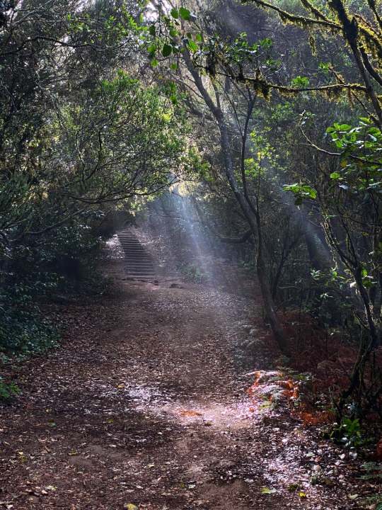
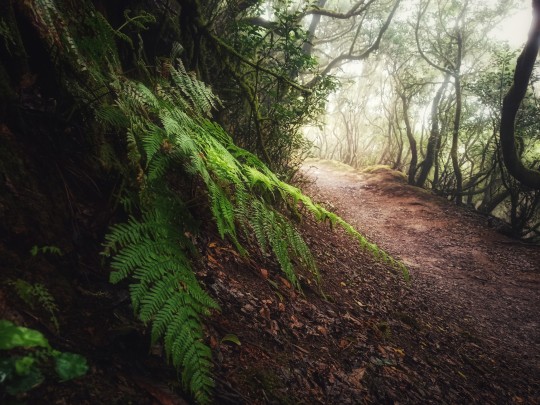
laurisilva forest ... | uwhe-arts
#laurisilva forest#laurisilva#cloud forest#photographers on tumblr#forest#misty#foggy#trees in the mist#uwhearts#uwhe-arts by uwe heinze#nature#in the woods#rainy morning#breathe deeply#enchant#enchanted forest#bewiched#elves forest#hiking#travel#journey#landscape#original creators#fujifilm x-t10#photooftheday
1K notes
·
View notes
Last Seen Blogs

wfobluesman
Untitled

distributormesinrakteluraceh
Distributor Mesin Rak Telur Aceh

mechanicallyhazardous
Mechanically Hazardous

daywoutmoon
a Day without a moon ~

yaboku05
Yaboku05