#Mapping
Explore tagged Tumblr posts
Visit Tumblr Blog
Explore Tumblr blogs with no restrictions, modern design and the best experience.
Last Seen Tumblr Blogs


Fun Fact
Tumblr has 411 employees.
Text
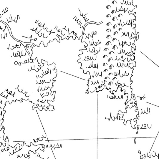
Planet Popstar World Map
Version 6
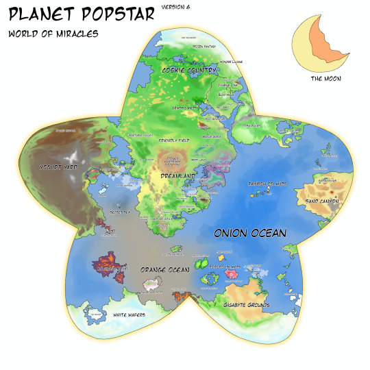
Version 6, but I think this might be the final version of the Planet Popstar map because im pretty sure all is good and well atp lol!!
Contains lots of levels and stages from various Kirby games, mainline and spinoffs. Spinoffs that would fit in with the mainline canon pretty well yeah lol..
Feel free to use the map I made!
UPDATED MAPS
(VERSION 7):
(VERSION 8)
#art#digital art#fanart#fanmade#map#worldmap#world map#fantasy map#fanmade map#kirby fanart#kirby series#kirby#planet popstar#pop star#popstar#planet#mapping
478 notes
·
View notes
Text
Unreleased (2018?)
#sci-fi#high-tech#cyberpunk#seal#magic seal#magic#graphic#graphics#projection#mapping#art#digital art#vector#illustration#drawing
273 notes
·
View notes
Text


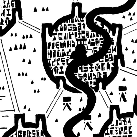
this is what I have so far of my one-room-a-day megadungeon project The Ziggurat of Sorrow, which I started on March 1st. So far it has 82 rooms drawn and keyed, with the final goal being 365 rooms after a full year. On the right is a sketch of the external structure superimposed on the internal layout :p
A lot of details like doors and internal room structures aren't shown here bc I'm mainly drawing it on a notebook, this digital version is just a rough sketch I use to be able to visualize the whole thing and keep the layout straight since on my notebook I have to split it into several pages.
437 notes
·
View notes
Text
To celebrate its 1000th anniversary, the Abbey of Montserrat has added light projections. This is a modern take on a centuries-old tradition.
The Abbey of Montserrat is the spiritual centre of Catalonia. It's located in the Montserrat mountain in Central Catalonia, a unique-looking mountain in the middle of a plain, which makes this holy mountain be seen from many parts of the country.
There's written evidence that a small community of monks has lived there since the year 880, but in 1025 one of the monks started the community that continues nowadays. Thus, this year they're celebrating their 1,000th anniversary.
The legend that explains its foundation is the same as many holy places in Catholicism (Found Virgin Marys). In 880, a group of children found a statue in a cave in the mountain. They warned the bishop, who ordered to take the statue to the nearest important church (Manresa), but the statue was so supernaturally heavy that it was impossible to move it. This was interpreted as meaning that She did not want to be moved, and thus a church was built there for Her. (The statue that is worshipped nowadays dates from the 1100s.)
Montserrat has lived through a lot of history. The Virgin of Montserrat became the patron saint of Catalonia together with Saint George. It has survived the Napoleonic French troops who set fire to the convent, and the repression of the Francoist fascist dictatorship. Montserrat became a symbol of Catalan resistance.
But it has also lived through changes in art history. The hermit chapels, monastery and other spaces of the sanctuary have been built between the Middle Ages and the present. One thing has remained constant: the use of art and new technologies to represent the religious stories. In the Middle Ages, with Gothic architecture, a new technology was developed that quickly became loved as a way to represent the more ethereal aspect of God: stained glass windows, an art of colourful light. Nowadays, we have new ways of using light. I see this new "mapping" as a continuation of this tradition.
What do you think of it?
#arts#montserrat#catalunya#light#art history#light art#mapping#video mapping#new art#contemporary art#religious art#catholic#europe#travel#catalonia
100 notes
·
View notes
Text

Susan Kare: “The Amtrak USA route system, interpreted in pixels for “The National” magazine in 2018.”
400 notes
·
View notes
Text


A recent map! The first image is the final result, and the second image is what the client provided. This was a fun one to make, very simple on a smaller scale and the client was happy to answer questions and give suggestions. I'm pretty happy with how it turned out.
115 notes
·
View notes
Text

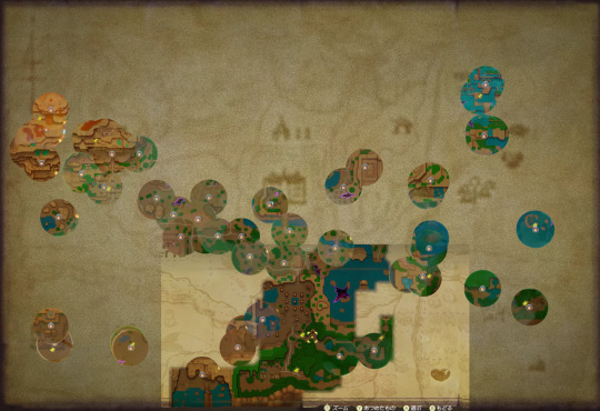
Art class project that I really enjoyed doing, each radial layer from the moon-like figure on the right represents a new type of map.

1st is the moon, which I was originally going to fully fill in, but the shaded face is a very nice look.
2nd is a map showing volcanic hotspots within the ocean along with ocean currents and landmass.
3rd is a map of surface insolation as is important for photosynthetic plants and bacteria.
4th is a map of nuerons meant to indicate complex memory as a mapping strategy as in herds and migrations.
5th is a map of magnetic declination, with a break between north and south facing magnetism near the bottom.
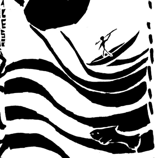
6th and on the right is meant to be a cave painting, with hand-prints and animal figures. The eyes on the top and bottom of the
7th and on the left is stylistically based on maps recovered in ancient times, with an emphasis on features and blocky texturing. The text within the boundaries of the city is a font I'm planning on using in a Monster Hunter project, and is technically in English. (King and Temple are legible in the first couple of lines)
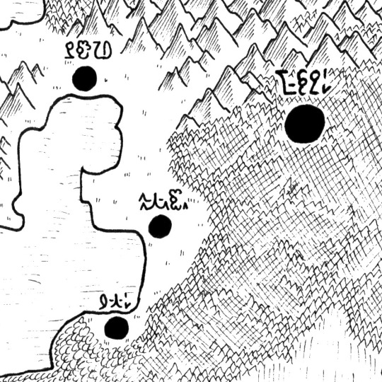
8th and on the right is the standard texturing I used on my PMD maps and features a script based off of my earliest conlang, but is using basically random glyphs. it is meant to be Medieval, and has coastlines which emphasis simple lines and curves.
9th and on the left is a naval map featuring many coastal cities, with their labels written in my main conlang script MAEPS. The coastlines emphasize bays to a major extent, with similarly blocky landmasses as the Medieval map.
10th and on the right is a topographic map with naturalistic coastlines, which sadly was drawn at the wrong scale for it to look good 😔
11th and on the left is a map drawn to emulate the aesthetics of GIS formatting, in particular the mountain and forest texturing which is cropped by the extent of their polygons. The coastlines continue to be naturalistic. The text is a font I'm planning on using in future pokemon projects and is based off of the font used in the gen 8/9 games. (the larger city in the bottom left corner reads Azumarill since I couldn't think of anything else to use)
47 notes
·
View notes
Text
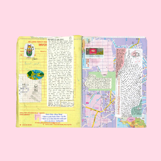
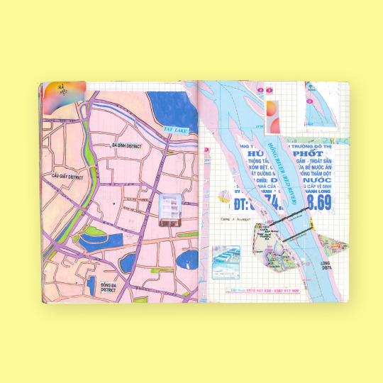
maps of hà nội (2023)
#collage#sketchbook#art journal#journaling#mixed media#notebook#map drawing#mapping#vietnam#hanoi#travel diary
287 notes
·
View notes
Text
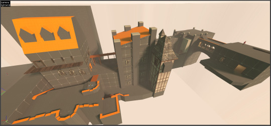
chat can someone tell me why I have spent so long remaking the Undead Burg from Dark Souls as a TF2 map. because i myself do not know
#i'm on autopilot at this point#just making shit#tf2#team fortress 2#dark souls#undead burg#level design#mapping
36 notes
·
View notes
Text
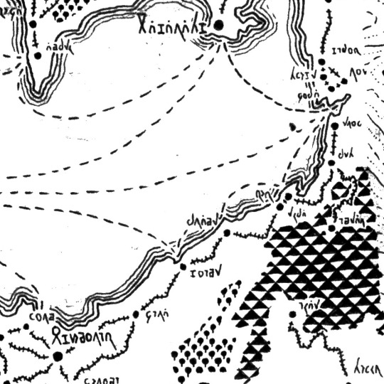
Heavenreach, Queendom of the Skywings
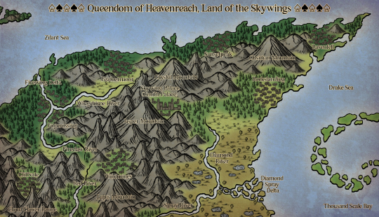
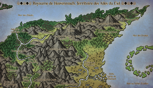
Left = English, Right = French
40 notes
·
View notes
Text
Planet Popstar World Map
Version 7
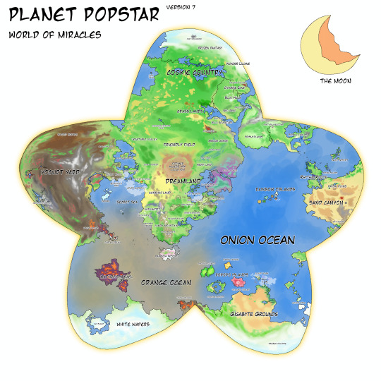
Okay nevermind it wasn't the final final version of the Planet Popstar map because I had a few changes in mind too...
— Rearranging a few locations here and there to fit in with the Kirby games they're in such as locations from Kirby's Adventure/Nightmare in Dreamland..
— Adding in the locations from Kirby Air Ride!!! They're all very far apart from each other really.
— Alongside that, Gurumetto! From Wikirby it's said that this is where Gourmet Race took place in, a large orchard region of sorts.
That's about it, feel free to use the map as you please, whether it'd be for a map in your kirby fanfic or whatever!
UPDATED MAPS
(VERSION 8):
#art#digital art#fanart#fanmade#map#worldmap#world map#fantasy map#fanmade map#kirby fanart#kirby series#kirby#planet popstar#pop star#popstar#planet#mapping
69 notes
·
View notes
Text


808 (2014)
#street art#street#projection#urban#videograffiti#seal#magic#magic seal#sci-fi#high tech#cyberpunk#graphic#graphics#art#abstract#abstract art#digital#digital art#vector#hud#fui#gui#mapping#808#cyber city
158 notes
·
View notes
Text
69 notes
·
View notes
Text
Mapping the upcoming iteration of Hyrule from The Legend of Zelda: Echoes of Wisdom (release date: September 26, 2024)
45 notes
·
View notes
Text
"As countries around the world begin to either propose or enforce zero-deforestation regulations, companies are coming under growing pressure to prove that their products are free of deforestation. But this is often a far from straightforward process.
Take palm oil, for instance. Its journey from plantations, most likely in Indonesia or Malaysia, to store shelves in the form of shampoo, cookies or a plethora of other goods, is a long and convoluted one. In fact, the cooking oil or cosmetics we use might contain palm oil processed in several different mills, which in turn may have bought the raw palm fruit from several of the many thousands of plantations. For companies that use palm oil in their products, tracing and tracking its origins through these obscure supply chains is a tough task. Often it requires going all the way back to the plot level and checking for deforestation. However, these plots are scattered over vast areas across potentially millions of locations, with data being in various states of digitization and completeness...
Palmoil.io, a web-based monitoring platform that Bottrill launched, is attempting to help palm oil companies get around this hurdle. Its PlotCheck tool allows companies to upload plot boundaries and check for deforestation without any of the data being stored in their system. In the absence of an extensive global map of oil palm plots, the tool was developed to enable companies to prove compliance with regulations without having to publicly disclose detailed data on their plots. PlotCheck now spans 13 countries including Indonesia and Malaysia, and aims to include more in the coming months.
Palm oil production is a major driver of deforestation in Indonesia and Malaysia, although deforestation rates linked to it have declined in recent years. While efforts to trace illegally sourced palm oil have ramped up in recent years, tracing it back to the source continues to be a challenge owing to the complex supply chains involved.
Recent regulatory proposals have, however, made it imperative for companies to find a way to prove that their products are free of deforestation. Last June, the European Union passed legislation that prohibits companies from sourcing products, including palm oil, from land deforested after 2020. A similar law putting the onus on businesses to prove that their commodities weren’t produced on deforested land is also under discussion in the U.K. In the U.S., the U.S. Forest Bill aims to work toward a similar goal, while states like New York are also discussing legislation to discourage products produced on deforested land from being circulated in the markets there...
PlotCheck, which is now in its beta testing phase, allows users to input the plot data in the form of a shape file. Companies can get this data from palm oil producers. The plot data is then checked and analyzed with the aid of publicly available deforestation data, such as RADD (Radar for Detecting Deforestation) alerts that are based on data from the Sentinel-1 satellite network and from NASA’s Landsat satellites. The tool also uses data available on annual tree cover loss and greenhouse gas emission from plantations.
Following the analysis, the tool displays an interactive online map that indicates where deforestation has occurred within the plot boundaries. It also shows details on historical deforestation in the plot as well as data on nearby mills. If deforestation is detected, users have the option of requesting the team to cross-check the data and determine if it was indeed caused by oil palm cultivation, and not logging for artisanal mining or growing other crops. “You could then follow up with your supplier and say there is a potential red flag,” Bottrill said.
As he waits to receive feedback from users, Bottrill said he’s trying to determine how to better integrate PlotCheck into the workflow of companies that might use the tool. “How can we take this information, verify it quickly and turn it into a due diligence statement?” he said. “The output is going to be a statement, which companies can submit to authorities to prove that their shipment is deforestation-free.” ...
Will PlotCheck work seamlessly? That’s something Bottrill said he’s cautiously optimistic about. He said he’s aware of the potential challenges with regard to data security and privacy. However, he said, given how zero-deforestation legislation like that in the EU are unprecedented in their scope, companies will need to sit up and take action to monitor deforestation linked to their products.
“My perspective is we should use the great information produced by universities, research institutes, watchdog groups and other entities. Plus, open-source code allows us to do things quickly and pretty inexpensively,” he said. “So I am positive that it can be done.”"
-via Mongabay, January 26, 2024
--
Note: I know it's not "stop having palm oil plantations." (A plan I'm in support of...monocrop plantations are always bad, and if palm oil production continues, it would be much better to produce it using sustainable agroforestry techniques.)
However, this is seriously a potentially huge step/tool. Since the EU's deforestation regulations passed, along with other whole-supply-chain regulations, people have been really worried about how the heck we're going to enforce them. This is the sort of tool we need/need the industry to have to have a chance of genuinely making those regulations actually work. Which, if it does work, it could be huge.
It's also a great model for how to build supply chain monitoring for other supply chain regulations, like the EU's recent ban on companies destroying unsold clothes.
#deforestation#palm oil#indonesia#malaysia#agriculture#european union#united states#save the forest#open source#technology#mapping#forestry#satellite#good news#hope#climate solutions#environment
123 notes
·
View notes