#Mount Osceola
Text

Landscape Language
Hydrothermal Alteration (noun) – the chemical and physical change of rocks through exposure to mineral-rich liquids and temperature changes.
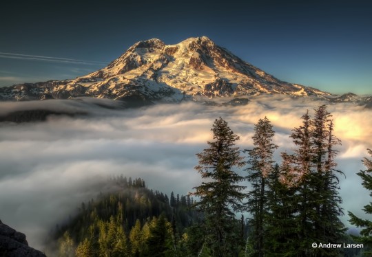
Notice the yellow-colored rocks at the base of the Tahoma Glacier in this photo? Those rocks have been changed through the process of hydrothermal alteration and are called “hydrothermally altered rocks”. In addition to lava, during active periods volcanoes produce heated mineral-rich fluids that break down the chemical structure of the rocks in the mountain’s volcanic peak. These weakened rocks are then more likely to fail during an eruption, as was the case during the Osceola Mudflow 5,600 years ago when the summit and a large extent of the east side of the volcano collapsed. Similarly altered rocks still exist on west flank of the mountain around the Sunset Amphitheater area and could be a future hazard.
NPS Photo of Tahoma Glacier and Sunset Amphitheater from Emerald Ridge, 1960s. ~kl
#Landscape Language#mount rainier national park#volcano#geology#Tahoma Glacier#Sunset Amphitheater#Osceola Mudflow#glaciers
49 notes
·
View notes


Text
Osceola Attacks - Today In Southern History
29 February 1836
On this date in 1836…
Chief Osceola’s force of 1,500 Seminole warriors mounted a major attack on the stockade of General Edmund Gaines on the Withlacoochee River in Florida. Many men on both sides are wounded during the attack.
Other Years:
1912 – South Carolina increased the minimum age for factory, mill, and mine workers to fourteen.
1892 – The city of St. Petersburg,…

View On WordPress
0 notes
Text
Progression of Peaks: Let’s Discover Mount Osceola, Field, South Kinsman, and Hancock
Mount Osceola - Elevation: 4340 ft
Difficulty Level: Like its east peak, Mount Osceola is generally considered an easy - moderate hike. As mentioned in my post from January 15th, this is an opportunity to peak bag. Please note that if one chooses this option, the hike will become more difficult. The trail between Mount Osceola and East Osceola has difficult rock scrambles and challenging terrain. I have hiked Mount Osceola (but have yet to summit the east peak) and I would recommend this as another great starter 4,000 footer.
Trail: The most direct route to the Mount Osceola summit can be accessed via the Mount Osceola trail. To peak bag East Osceola, take the Mount Osceola and East Osceola trail. The first link is from myhikes.org, and provides the directions for the Mount Osceola Trail. The second link is from AllTrails, which includes the Mount Osceola and East Osceola trail.
Mount Osceola Trail - White Mountain National Forest, NH | MyHikes
Mount Osceola and East Osceola, New Hampshire - 3,235 Reviews, Map | AllTrails
This is a picture of my own from when I summited Mount Osceola in the summer of 2021:

Mount Field - Elevation: 4340 ft
Difficulty Level: With Mount Field, we continue on with an easy - moderate hike. You make remember this name from my January 22nd post, where I briefly touch upon the opportunity to peak bag Mount Field when trekking Mount Willey. As always, adding a peak lengthens your journey, and thus results in a more difficult hike. If you are up for the challenge, I recommend considering bagging Mount Willey, Mount Tom (or both), or even Mount Avalon as well. Please note that Mount Avalon is NOT considered a 4,000 footer.
Trail: There are various routes to hit the summit of Mount Field. The hikers choice depends on preference for peaks they wish to hit, and the length they are willing to hike. The most popular trails to access Mount Field include the Mount Tom, Avalon, and Field Loop, and the Avalon A-Z, Willey Range Trail. AllTrails linked below:
Mount Tom, Avalon, and Field Loop, New Hampshire - 1,275 Reviews, Map | AllTrails
Mt. Tom, Field, and Willey via Avalon, A-Z, and Willey Range Trail, New Hampshire - 208 Reviews, Map | AllTrails
View from Mount Field:

Mount Field Mt Field 4331 feet Whitefield NH New Hampshire Grafton County Hike Hiking New England NE 4000 Footers Footer Mountain Mountains Trails Trail Summit Peak Bagging Peak Bag Ripley Falls Willey Range White Mountains Mount Tom Mount Willey Waterfall Willey Range Trail Ethan Pond Trail Appalachian Trail Mount Willard Mount Avalon Avalon Trail A-Z Trail Bugle Cliff. (n.d.). http://4000footers.com/field.shtml
South Kinsman Mountain - Elevation: 4358 ft
Difficulty Level: Similar to North Kinsman mountain (discussed in last week’s post), South Kinsman mountain is a difficult hike. It includes rock scrambles, and it is a longer route. Please do not attempt this hike until you have completed multiple 4,000 footers and are prepared. The trails I mention below include peak bagging, with both North Kinsman Mountain and Cannon Mountain.
Trail: The most traveled trails to reach the summit of South Kinsman are the Fishin Jimmy trail (out and back trail), Kinsman Ridge Trail, and Lonesome lake, Fishin Jimmy, and Kinsman pond. Each route has something unique and awesome to offer, so be sure to review the options diligently before choosing! AllTrails link below:
North Kinsman and South Kinsman Trail via Fishin Jimmy Trail, New Hampshire - 1,737 Reviews, Map | AllTrails
Cannon, North and South Kinsman via Kinsman Ridge Trail, New Hampshire - 91 Reviews, Map | AllTrails
North-South Kinsman via Lonesome Lake, Fishin’ Jimmy, and Kinsman Pond, New Hampshire - 164 Reviews, Map | AllTrails
View from South Kinsman in the winter:

Dailey, C. (n.d.-b). Cannon Mountain, North Kinsman, and South Kinsman ~ April 6th, 2013. https://whitemountainimages.blogspot.com/2013/04/cannon-mountain-north-kinsman-and-south.html
Mount Hancock - Elevation: 4420 ft
Difficulty Level: Mount Hancock is a moderate hike. As I mentioned in last week’s post, this mountain presents another chance to knock out another 4,000 footer: Mount Hancock, South Peak! As always, I advise those looking to hike multiple peaks in one day to prepare for these treks. South Hancock mountain is 1.2 miles from the summit of Hancock mountain, so please be mindful of this.
Trail: The most commonly hiked route is the Hancock Trail. AllTrails link below:
Hancock Trail, New Hampshire - 3,454 Reviews, Map | AllTrails
View from near the summit of Mount Hancock:

FranklinSites.com. (n.d.-a). Mt. Hancock (South Peak), Mt. Hancock (North Peak) - New Hampshire - November 3, 2010 Hike Trip Report - FranklinSites.com Hiking guide. https://www.franklinsites.com/hikephotos/NewHampshire/mthancocksouth-2010-1103.php
0 notes
Note
No but why is it called mount Osceola? That man was definitely not from nor had anything to do with New England lol
I have zero idea ngl
1 note
·
View note
Text
Speeko tech nsl wireing dieg

Speeko tech nsl wireing dieg manual#
Speeko tech nsl wireing dieg full#
Speeko tech nsl wireing dieg code#
Speeko tech nsl wireing dieg professional#
Speeko tech nsl wireing dieg code#
If you are looking for small business insurance, you can request a free Iowa City, Iowa commercial insurance quote, or in these other IA cities: Adel, Algona, Altoona, Ames, Anamosa, Ankeny, Asbury, Atlantic, Bettendorf, Bondurant, Boone, Burlington, Camanche, Carlisle, Carroll, Cedar Falls, Cedar Rapids, Centerville, Chariton, Charles City, Cherokee, Clarinda, Clear Lake, Clinton, Clive, Coralville, Council Bluffs, Creston, Davenport, DeWitt, Decorah, Denison, Des Moines, Dubuque, Dyersville, Eldridge, Estherville, Evansdale, Fairfield, Forest City, Fort Dodge, Fort Madison, Glenwood, Grimes, Grinnell, Hampton, Harlan, Hiawatha, Humboldt, Independence, Indianola, Iowa City, Iowa Falls, Jefferson, Johnston, Keokuk, Knoxville, Le Claire, Le Mars, Manchester, Maquoketa, Marion, Marshalltown, Mason City, Monticello, Mount Pleasant, Mount Vernon, Muscatine, Nevada, Newton, North Liberty, Norwalk, Oelwein, Orange City, Osceola, Oskaloosa, Ottumwa, Pella, Perry, Pleasant Hill, Polk City, Red Oak, Sergeant Bluff, Sheldon, Shenandoah, Sioux Center, Sioux City, Spencer, Spirit Lake, Storm Lake, Urbandale, Vinton, Washington, Waterloo, Waukee, Waverly, Webster City, West Des Moines, Windsor Heights, Winterset and all other IA cities & Iowa counties near me in The Hawkeye State.Īlso find IA local small businesses by General Liability Class Code and learn about Iowa small business insurance requirements for general liability, business property, commercial auto & workers compensation including IA business insurance costs. Different network intrusion detection systems (NIDSs) proposed for the CAN bus, the predominant type of in-vehicle network, to improve security are hard to compare due to disparate evaluation. South Carolina Small Businesses Near Me.North Carolina Small Businesses Near Me.You can go to your iTunes Account Settings to manage your subscription and turn off auto-renew.Īny unused portion of a free trial, if offered, will be forfeited when you purchase a subscription.Speeko Tech, LLC's NCCI Class Code is: NCCI Class Code(s)īrowse The Local Small Businesses Near Me Directory Your account will be charged for the renewal within 24 hours prior to the end of the current period, and the cost of the renewal will be identified. Your Speeko subscription will automatically renew unless auto-renew is turned off at least 24 hours before the end of the current period. Your iTunes Account will be charged when the purchase is confirmed. ETK Elektronikteilkatalog (BMW part numbers & descriptions) ETM BMW electrical troubleshooting manual.
Speeko tech nsl wireing dieg manual#
Pricing in other countries may vary and actual charges may be converted to your local currency depending on the country of residence. Wiring Diagram VW NEW BEETLE 2000 - Battery - ignition/starter switch - X contact relief relay ABattery BStarter DIgnition/starter switch J59X contact relief relay S162Fuse -1- (30), in fuse box/battery S163Fuse -2- (30), in fuse box/battery S164Fuse -3- (30), in fuse box/battery S176Fuse -4- (30), in fuse box/battery S177Fuse -5- VW NEW BEETLE 2000 Body electrical. EBA Einbauanleitung (from RealOEM, e.g., in cupholder EBA 9789813) Einbauanleitung Options Installation Manual (as specified in Realoem) Entwurfen 39 project 39, aka E39. These prices are for United States customers. Yearly: $4.17 per month, one payment of $49.99 billed every 12 months Speeko offers two auto-renewing subscription options:
Speeko tech nsl wireing dieg professional#
Speeko is the world's smartest personal speech coach to help you improve your professional speaking style.
Speeko tech nsl wireing dieg full#
Our coaching library is full of tips to help you speak your best. Speeko intelligently recommends lessons and exercises based on your performance. The more you use Speeko, the better it gets. After that, you' get instant, personalized feedback on how well you did, including how quickly you speak, how dynamic you sound, and a filler word counter (your um's and ah's). Use the voice recorder to practice for an interview, a debate team event, or speaking off-the-cuff (like giving a wedding toast). Multi-Diag delivers fast and easy diagnostics on all major truck. Have you dreamed of giving your own "I Have a Dream" speech? Ever feel like anxiety has gotten the best of you when you were on stage? Speeko will teach you the core speaking techniques to achieve effective delivery of your message when it matters most. Public speaking practice and instant feedback.
1 note
·
View note
Video
youtube
Mount Osceola with friends! #HomeboiPhotography #MountOsceola #NewHampshire #Nikon #Tamron #Tokina #18400mm #100mm #MacroPhotography #1024mm
#HomeboiPhotography#Mount Osceola#Mt Osceola#New Hampshire#Macro#Tamron#Tokina#Nikon#D500#18400mm#1024mm#100mm
1 note
·
View note
Photo

10 notes
·
View notes
Photo

Day’s End.
31 notes
·
View notes
Text
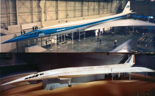
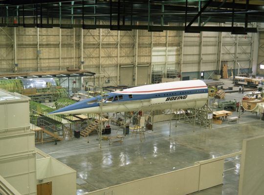
-Mockups of the two final American SST concepts, the Boeing 2707 and the Lockheed L-2000. | Composite Photo: Justin Gibb
FLIGHTLINE: 136 - AMERICAN SST PROGRAM
Various programs to develop a supersonic transport in the US stretched from the middle 1950s until the early 1970s, but no aircraft ever resulted.
The first recorded supersonic flight (the speed of sound is 767mph at 20°C/68°F at sea level) was on 14 October 1947, when the American X-1, piloted by Chuck Yeager, reached Mach 1.06. By the 1950s, supersonic flight became a more regular occurrence, though it was still almost exclusively restricted to military pilots. Around this time, various projects around the world began to develop airliners that could break the sound barrier too. Designs like the Sud Aviation Super-Caravelle and Bristol Type 223 were sketched, but technical limitations as well as a lack of funding stalled those efforts.
♫NINETY MINUTES FROM NEW YORK TO PARIS♫
Research continued however, and by the early-1960s a new round of programs were started, with BAC (later BAe and BAE Systems) and Sud Aviation (later Aérospatiale and Airbus) joining forces to produce what became Concorde, while the Soviet design bureau Tupolev developed the Tu-144 (NATO reporting name "Charger"). Numerous American carriers placed orders for Concorde aircraft, but spiraling costs and a desire to develop a domestic SST saw those orders canceled in the early 1970s. In the end, only Air France and BOAC/British Airways operated Concorde, while the Tu-144 was exclusively flown by the Soviet state airline Aeroflot.
BUY AMERICAN!
The FAA estimated in the early 1960s that there would be a market for 500+ SSTs by the year 1990. Fearing Anglo-French domination of the airline industry, the US Congress began funding various research programs, and President John F Kennedy announced a National Supersonic Transport program on 5 June 1963. Requests for proposals were sent to Boeing, Lockheed, and North American for the airframes; and Curtiss-Wright, General Electric and Pratt & Whitney for engines. The request stipulated a cruise speed of Mach 3, and a passenger capacity of up to 300. Preliminary designs were submitted on 15 January 1964

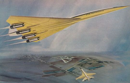
-Line drawing of the Boeing 733-790 SST, which initially featured swing wings. | Illustration: Boeing
The Boeing 733 model featured a large blended wing root with variable geometry outer panels, resembling an enlarged Rockwell B-1. The proposal included optional fuselage extensions, potentially increasing capacity to 227 passengers.

-Line drawing of the the CL-823. | Illustration: Lockheed Corp.
Lockheed's CL-823 was functionally an enlarged Concorde, though the wing shape was a cranked arrow rather than Concorde's ogival delta.
The North American NAC-60 was the smallest and slowest of the competitors, potentially transporting 187 passengers at Mach 2.65.
In 1965 the FAA downselected the NAC-60 design, as well as Curtiss-Wright's engine work, freeing up funds for Boeing and Lockheed on the airframe side and P&W and GE for the engine development.
TIME TO SHARPEN YOUR PENCIL.
The FAA scheduled a final selection in 1966, and requested detailed proposals from Boeing and Lockheed. Boeing had gone through several iterations of the Model 733, with the 733-390 being presented in September 1966. The aircraft was one of the first wide-body airliners, with 2-3-2 seating. In the 30-seat first class section, small tv's were to be integrated into a console between the seats, while in the 247-seat tourist class section larger retractable tv's would drop from the overheads every six rows. Externally, the engine pods had been moved back under the tail, and the wings, when swept back, would form a delta with the tail.
-Illustration of the 733-390, with one at maximum sweep and one at minimum. | Illustration: Boeing.
Lockheed's CL-823 had evolved as well, with the L-2000-1 design having changed from a cranked arrow to a delta wing, with the engines separated into individual pods. In order to speed production, the L-2000 was projected to use a derivative of the J58 engine that had powered the A-12 OXCART and SR-71 Blackbird. New requirements from the government saw changes to the wing and fuselage, and the engine pods were redesigned to accommodate either the P&W JTF-17A or GE4 designed as part of the SST program. The final design presented to the FAA was the L-2000-7A/B (the B was 20 feet longer), which had a passenger capacity of 230.

-Advertising image of the L-2000-7A. | Illustration: Monsigneurhulot
THE FINAL SHOWDOWN
The final designs, complete with full-scale mockups, were presented in September 1966.

-The full-scale mockup of the 733-390, in a striking white-over-yellow paint scheme. The size of the plane is evident from the man standing near the third jack. | Photo: Boeing
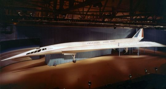
-Appearing no less impressive, the Lockheed L-2000 mockup. | Photo: Lockheed
FAA review of the competing SSTs took until December, with the Boeing design being announced the winner on 1 January 1967. The L-2000 was judged to easier to produce, but it was also thought to be less risky and advanced than the Boeing entry, and thus the latter was more in the spirit of the design mandate. Also, the Lockheed craft was anticipated to be louder with the JTF-17A engines, as well as being slower.
Boeing anticipated construction of the 733-390 prototypes, now referred to as the 2707-200, would begin in 1967, with first flight in 1970. Construction of the production models was expected to commence 1969, with first flight in 1972 and FAA certification anticipated by 1974.

-The public enthusiasm for the SST program was initially high, with scale models and toys of the design being release by multiple companies. Seattle's NBA team, formed in 1967, was initially named the SuperSonics. | Photo: oldmodelkits.com
NO PLAN SURVIVES FIRST CONTACT WITH THE ENEMY (IN THIS CASE, PHYSICS)
Almost immediately, Boeing began encountering problems with the design. Canards were added to improve flight characteristics, but this added weight. The swing wing mechanism were also much heavier than anticipated, with one pivot section being an eleven feet long, two-and-a-half feet thick piece of titanium weighing 4,600lbs. All of this added weight was eating into the plane's range and lowering the speed, and in October 1968 the company made the decision to delete the variable geometry wings and utilize a fixed delta instead. Fabrication of a mockup of the new design, the 2707-300, as well as two prototypes, commenced in September 1969. Despite these issues and delays, by October 1969 Boeing had orders for 122 2707s from 26 airlines, including Alitalia, Canadian Pacific Airlines, Delta Air Lines, Iberia, KLM, Northwest Airlines, and World Airways.
It was during this period however than organized opposition to SSTs became more pronounced. During the first half of 1964, the FAA conducted Operation Bongo II, under which Oklahoma City, Oklahoma was subjected a total of 1,253 sonic booms. Up to eight booms were scheduled, beginning at 7am and ending in the afternoon. Various aircraft were used, from fighters like the F-104 to bombers like the B-58 and XB-70. The results of the experiment were encouraging, with only 9,594 complaints of damage to buildings, 4,629 formal damage claims, and 229 claims for a total of $12,845.32 ($108.983.34 in 2021). 73% of subjects in the study said that they could live indefinitely with eight sonic booms per day, while 25% said that they couldn't. Approximately 3% of the population filed complaints or lawsuits. The FAA's handling of the program and response to the claims completely undid the public's acceptance of supersonic flight however. The program was undertaken with minimal engagement of the local authorities, and afterwards the FAA dismissed 94% of the claims received, attracting the ire of state and national leaders. Class action lawsuits were filed against the government, and public opinion turned against the SST. This culminated in a national ban on supersonic flight over land. Another source of concerns was the exhaust from the jet engines, specifically nitrogen oxides, which were found to damage stratospheric ozone. A fleet of 500 SSTs was calculated to cause a drop in ozone of 1 to 2%, though changes in fuel and engine technology would help mange this.
THE COLLAPSING STAGE...
The mounting environmental concerns, souring public perception, continuing technical hurdles and competing projects saw the funding for the SST program drying up. Both the House and Senate voted in 1971 to end funding for the program, spelling the end of American SST. Whatever work completed on the prototypes was dismantled, and the one completed 2707-300 mockup was sold to the SST Aviation Exhibit Center in Florida, which displayed it from 1973 until 1981. Hard times saw the closure of the museum, which was then sold to the Faith World Church in 1983. For the next seven years, the Osceola New Life Assembly of God held services beneath the wing of the only remaining example of the US' supersonic airliner program.
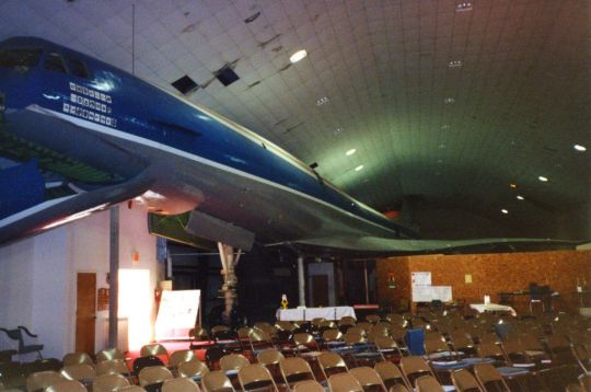
-The 2707 mockup some time in the 1980s. Sunday school classes were held under the port wing for nearly a decade. | Photo: Boeing
In 1990 the remnants of the mockup were sold to Stan Hiller, helicopter pioneer and owner of the Hiller Aviation museum. In 2013 the forward 90' section of the fuselage, now all that remained, were shipped to the Museum of Flight was part of a transfer between the two museums. What's left of the 2707-300 is now under restoration; the last remnants of a grand dream to move air travel forward at Mach 3.
-The remaining segment of the 2707, now 50 years after the program's termination. | Photo: Boeing
#aircraft#aviation#avgeek#airplanes#airplane#cold war#cold war history#coldwar#usaf#aviation history#sst#seattle supersonics#supersonic jet#supersonic transport#supersonic airliner#Boeing#Lockheed#the 60s#the 70s#the sixties#the seventies#faa#air travel#Concorde#boac#air france#Tupolev#tu-144#tu 144#concordeski
96 notes
·
View notes
Photo
Mount Rainier
Dominating the skyline of Seattle stands the highest peak (4392 m/14411 ft) in the Cascade Mountain Range, Mount Rainier. Along with other notable volcanoes in the Cascades, Mount Rainier formed as a result of subduction along the Cascadia subduction zone, where melting and crustal contamination generates a high silica, high water content magma. This magma composition presents at the surface in a very particular way; large stratovolcanoes with the potential for large, explosive eruptions.
Located on the leading edge of the Cascades, Mount Rainier is located just 87 km/54 miles to the south-east of Seattle. Parts of the city of 634,535 people, as well as the city of Tacoma (202,010 people) and surrounding towns are built on ash and lahar deposits from Rainier.
Along with the 20 or so major stratovolcanoes in the Cascade Arc, Rainier is capable of large, explosive eruptions similar to that of Mount St Helens in 1980. The geologic record shows that continuous eruptions have been occurring at Rainier for 500,000 years, fluctuating between periods of higher and lower eruption rates (We are in the latter).
The eruptions themselves however, are not the only, nor the biggest threat the volcano poses. The mountain is home to 26 major glaciers which feed several rivers (Cowlitz, Nisqually, Puyallup, Carbon and White) that during an eruption would be vulnerable to lahars created by the sudden release of glacial meltwater. The USGS estimates that 150,000 people live on top of past lahar deposits from Rainier, including areas of Seattle and nearby Tacoma.
Hydrothermal alteration on the mountain is also of concern. A mixture of magmatic fluids, hydrothermal fluids, and steam have acted to chemically alter the volcanic rocks, making them weaker in the process. Widespread alteration on the steep sided flanks of Rainier makes them vulnerable to collapse, a process evident in the geological record. Approximately 5,600 years ago, 2-3 km^3 of mostly altered material from the summit and N-E flank detached from the mountain, creating a lahar that reached as far as the Puget Sound. This event, known as the Osceola Mudflow, created a horseshoe shaped crater not unlike that created after Mt St Helens erupted, which has since refilled with later lavas. Most of the heavily altered rock from the volcano was removed in this event, but some does remain on the upper west flank and presents a collapse hazard. These flank failure events can prove particularly hazardous as they do not necessarily require volcanic or seismic activity to occur; instead failing due to their own structural weakness.
There are no current signs of renewed activity at Mount Rainier, which is heavily monitored for any activity that suggests the contrary. Rainier has not had a major eruption in recent times, but its eventual awakening will no doubt make headline news worldwide.
USGS: Mount Rainier - http://on.doi.gov/PctRUI
Hydrothermal Alteration on Rainier - John, D. A., Sisson, T. W., Breit, G. N., Rye, R. O., & Vallance, J. W. (2008). Characteristics, extent and origin of hydrothermal alteration at Mount Rainier Volcano, Cascades Arc, USA: Implications for debris-flow hazards and mineral deposits. Journal of Volcanology and Geothermal Research, 175(3), 289-314. - http://bit.ly/1hdKn4Q
The Osceola Mudflow - Vallance, J. W., & Scott, K. M. (1997). The Osceola Mudflow from Mount Rainier: Sedimentology and hazard implications of a huge clay-rich debris flow. Geological Society of America Bulletin, 109(2), 143-163. - http://bit.ly/1KKcmWy
Deep magma reservoir below Mt Rainier - http://on.fb.me/1IECxvm
Image Credits - Andrew E. Larsen - http://bit.ly/1OY1nrh, Poyson - http://bit.ly/1Hj5zvd, Hazard Map - USGS http://on.doi.gov/1JG1p6W
RJW
#mount rainier#science#volcano#lahar#geology#hazard#volcanomonday#washington#pnw#tacoma#the earth story
102 notes
·
View notes
Text
Summer and wildflowers come late to the high elevations of the Cascade Mountains. In the sub-alpine meadows, snow might linger into July some years. This makes building and maintaining roads to the sub-alpine elevations quite challenging.

One of these challenging roads is the road stretching 10 miles from the White River Campground turn-off up to the Sunrise Visitor Center; the Sunrise Road. Currently, the Sunrise Road is still closed from the winter. Typically, it opens in early July after road crews have plowed the snow off, cut up any trees that fell across the roads, removed rocks, dirt, and done everything needed to make the road safe for summer access.
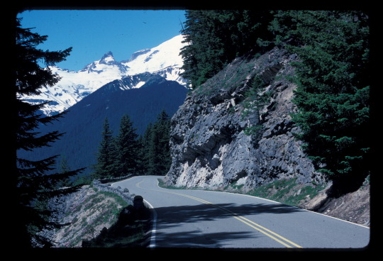
Can you imagine what it was like to build the Sunrise Roads in 1929? In the 10 miles from White River Campground to Sunrise parking lot, the road climbs up the steep sides of the White River Valley. Carved by the once 1,000 foot tall Emmons Glacier, it is a very steep slope. The hillside is made of rocks, boulders, and fine materials left behind by the Osceola Mudflow nearly 5,600 years ago. Higher up, it’s hardened lava from volcanic eruptions. In 1929, through 4 different construction contracts, crews worked their way upwards carving the road out of the mountain. The road was completed the next year and construction began on the infrastructure and buildings at Sunrise.

Though closed right now, when it opens for the summer, the Sunrise Road and the many trailheads at Sunrise itself are very popular and have been for many decades. When was the last time you drove up this road along the valley walls of the White River? What is your favorite spot for pictures? ~ams
The Sunrise Road and White River Campground are currently closed. Updates on their opening can be found at https://www.nps.gov/mora/planyourvisit/road-status.htm and https://www.nps.gov/mora/planyourvisit/hours.htm . For more information on the history and archaeology of the park, see https://www.nps.gov/mora/learn/historyculture/index.htm
NPS/B. Bullard Photo. View of an old car driving downhill on the Sunrise Road with Mount Rainier in the distance. September, 1963. NPS/L. Lane Photo. Sunrise Road with columnar andesite on the roadside. Mount Rainier in background. Circa 1987. NPS/Scott Photo. View from near Camp Schurman looking down on Yakima Park and Sunrise Road. August, 2004.
#encuentra tu parque#find your park#history#roads#Sunrise#national parks#mount rainier#mount rainier national park
29 notes
·
View notes
Text
*~ The 2020 Family Massacre ~*

Alleged family murderer Anthony Todt was found with the bodies of his wife and kids wrapped in blankets and left to decay in his bedroom, according to authorities’ grisly reports from the crime scene released Friday.
The local sheriff deputies were immediately struck by a “strong foul odor” when they first stepped foot in the Todt’s Family home in Celebration, Florida, on Monday, Jan. 13 2020 - what they discovered to be the stench from the bodies that had permeated from a second-floor room.
Todt allegedly confessed to the brutal slayings and is facing four charges of murder in the death of his wife, Meghan, 42, their three chidlren — Alek, 13, Tyler, 11, and Zoe, 4. All but Zoe were found with stab wounds at the scene and were very visibly decomposing, a deputy said.
“While standing outside of the master bedroom, I could see a person laying on the floor who was wrapped in blankets,” one deputy reported. “Sticking out of the blankets was a foot that was black and blue in color.”

The deputies discovered all four bodies of the family while accompanying federal agents to the home to serve a warrant for Todt’s arrest over the allegations of health care fraud.
They entered the home after noticing the front door was unlocked, according to the incident reports from the Osceola County Sheriff’s Office.
At that point Todt’s family hadn’t heard from them for more than a week and Anthony Todt had mounting financial debts as well as being investigated by the Federal Government due to allegations of Fraud. The family was also facing eviction from their rental home in Florida as well as at Anthony’s physical therapy practice back in Colchester, Connecticut.
As authorities entered the home Todt came to the bottom of the stairs and claimed his wife was sleeping and was not to be awoken. But according to Deputies he was clearly disturbed, and he seemed out of sorts.
“Anthony could barely stand and appeared to be disgruntled and shaking,” a deputy reported.
They called out to his wife, Meghan. When they heard no response they ascended the flight of stairs; found the bodies and placed Todt under arrest.
Thanksgiving was the last time Todt was seen by family, after which he was recently interviewed by federal agents for their fraud investigation.
“There are concerns,” a federal agent said in a phone call to the sheriff’s office before they descended on the home. “Todt does know that he is being investigated and as far as I know he’s tapped out of all his financial resources.”
The story continues...
#tcc#true crime community#true crime#murder#murderer#criminal#crime#reblog#follow#killer#mass murder#mass murderer#family killer#family murder#homicide#familicide#shocking crimes#true crime facts#facts about true crimes#like this#share#family murderer#anthony todt#family massacre#massacre#todt family#true crime news#breaking news#popular#tumblr
274 notes
·
View notes
Text
Share your era
Heat Advisory
URGENT - WEATHER MESSAGE
National Weather Service Grand Rapids MI
307 PM EDT Sat Aug 28 2021
MIZ037>040-043>046-050>052-056>059-064>067-071>074-290000-
/O.CON.KGRR.HT.Y.0002.000000T0000Z-210829T0000Z/
Mason-Lake-Osceola-Clare-Oceana-Newaygo-Mecosta-Isabella-Muskegon-
Montcalm-Gratiot-Ottawa-Kent-Ionia-Clinton-Allegan-Barry-Eaton-
Ingham-Van Buren-Kalamazoo-Calhoun-Jackson-
Including the cities of Ludington, Baldwin, Reed City, Clare,
Hart, Fremont, Big Rapids, Mount Pleasant, Muskegon, Greenville,
Alma, Grand Haven, Jenison, Grand Rapids, Ionia, St. Johns,
Holland, Hastings, Charlotte, Lansing, South Haven, Kalamazoo,
Battle Creek, and Jackson
307 PM EDT Sat Aug 28 2021
...HEAT ADVISORY REMAINS IN EFFECT UNTIL 8 PM EDT THIS EVENING...
* WHAT...Heat index values in the upper 90s to low 100s expected.
* WHERE...Portions of central, south central, southwest and west
central Michigan.
* WHEN...From 2 PM to 8 PM EDT today.
* IMPACTS...Hot temperatures and high humidity may cause heat
illnesses to occur. Strenuous outdoor activities are not
advised.
PRECAUTIONARY/PREPAREDNESS ACTIONS...
Drink plenty of fluids, stay in an air-conditioned room, stay out
of the sun, and check up on relatives and neighbors. Young
children and pets should never be left unattended in vehicles
under any circumstances.
Take extra precautions if you work or spend time outside. When
possible reschedule strenuous activities to early morning or
evening. Know the signs and symptoms of heat exhaustion and heat
stroke. Wear lightweight and loose fitting clothing when
possible. To reduce risk during outdoor work, the Occupational
Safety and Health Administration recommends scheduling frequent
rest breaks in shaded or air conditioned environments. Anyone
overcome by heat should be moved to a cool and shaded location.
Heat stroke is an emergency! Call 9 1 1.
&&
$$
For more information from the National Weather Service visit
https://weather.gov/grr
1 note
·
View note
Text
Elevate and Escalate: Climbing Mount Hale, Wildcat, Cannon, Middle Tripyramid, Osceola, and Cabot
Mount Hale - Elevation: 4054 ft
Difficulty Level: Mount Hale is another summit I would recommend for those seeking an easier hike. An important factor to be aware of when planning your hike on Mount Hale is potential road closures that impact access to the trailhead. Please monitor local weather reports to assess the risks throughout every season. Additionally, the summit is mostly wooded, but clearly marked with a cairn. It is beautiful during the winter though!
Trail: The two most popular trails hiked are the Fire Warden Trail and Hale Brook Trail . AllTrails links below:
Mount Hale via Fire Warden Trail, New Hampshire - 264 Reviews, Map | AllTrails
Explore Mount Hale via Hale Brook Trail | AllTrails
View From Hale:

hike Mount Hale NH. (n.d.). https://www.nhmountainhiking.com/hike/hale/dave_big.html
Mount Wildcat, D Peak - Elevation: 4070ft
Difficulty Level: With Mount Wildcat, D Peak, we move to a more moderate - difficult hike. The climb on this trail is persistently steep, so if you are looking for a great opportunity for a cardio workout, this is the one! This is another difficult hike with a very high reward: an amazing view of the presidential range. My mom finished her 48 4,000 footers on this range, so this is a very special one to me as well! Wildcat is also a ski mountain, so I also encourage anyone visiting the area during the winter to check out the slopes too.
Trail: There are two popular ways to hike Wildcat, D peak. There is an out and back trail via Wildcat Ride Trail, or via completing the entire Wildcat Ridge Trail. Both AllTrails link below:
Wildcat D via Wildcat Ridge Trail, New Hampshire - 227 Reviews, Map | AllTrails
Wildcat Ridge Trail, New Hampshire - 503 Reviews, Map | AllTrails
View from Wildcat, D Peak:

TheHikingGeek. (2018, September 15). NH 48 4000 footers: Wildcat Mountain D via Polecat Ski Trail - Gorham, NH (May 2, 2018) - Hiking photos, trip reports, trail info and gear reviews. Hiking Photos, Trip Reports, Trail Info and Gear Reviews. https://www.hikinggeek.com/2018/05/02/nh-48-4000-footers-wildcat-mountain-d-via-polecat-ski-trail-gorham-nh-may-2-2018/
Cannon Mountain - Elevation: 4,100ft
Difficulty Level: Cannon mountain follows suit with Wildcat, being a high work, high reward mountain. It is seen as a moderately difficult hike, due to its steepness and terrain. Another similarity that this mountain shares with Wildcat is that it is a ski mountain. I grew up skiing these slopes, so when I got to summit it three summers ago, it was an incredible experience. The view never gets old!
Trail: Two popular trails to summit Cannon Mountain are via Kinsman Ridge Trail, or via Lonesome Lake Trail. AllTrails links below:
Cannon Mountain via Kinsman Ridge Trail, New Hampshire - 2,990 Reviews, Map | AllTrails
Cannon Mountain via Lonesome Lake Trail, New Hampshire - 378 Reviews, Map | AllTrails
This is a picture of my own!

Middle Tripyramid Mountain - Elevation: 4140ft
Difficulty Level: Middle Tripyramid is generally seen as a moderately difficult hike. This is a mountain is situated near another 4,000 footer (North Tripyramid), which is perfect if you are looking to peak bag. Most trails for this mountain are rather long in distance, so I recommend holding off on any of the Tripyramid until you are well experienced.
Trail: The most popular trail hiked is the Mount Tripyriamd loop trail. AllTrails link below:
Mount Tripyramid Loop Trail, New Hampshire - 1,750 Reviews, Map | AllTrails
View from Middle Tripyramid:

Mount tripyramid. (2020, September 19). https://robsinthewoods.com/091920_tripyramids.html
Mount Osceola, East Peak - Elevation: 4156ft
Difficulty Level: The East Peak of Mount Osceola is considered an easy - moderate hike. It is possible to bag both the east peak and the main peak of Mount Osceola (will discuss in a later blog post) but the trail between the two has rock scrambles, which can be more difficult.
Trail: Two popular trails that Mount Osceola, East peak can be summited are via Greeley Ponds Trail, and the Mount Osceola and East Osceola trail. AllTrails links below:
East Osceola via Greeley Ponds Trail, New Hampshire - 439 Reviews, Map | AllTrails
Mount Osceola and East Osceola, New Hampshire - 3,234 Reviews, Map | AllTrails
View from Osceola, East Peak:

FranklinSites.com. (n.d.-b). Mt. Osceola (East Peak), Mt. Osceola - New Hampshire - January 16, 2010 Hike Trip Report - FranklinSites.com Hiking guide. https://www.franklinsites.com/hikephotos/NewHampshire/mteastosceola-2010-0116.php
Mount Cabot - Elevation: 4170ft
Difficulty Level: We return to some longer trails with Mount Cabot. Cabot is considered an easy - moderate hike. The more difficult parts of the trails are the boulders that must be scaled. It is important to know how to navigate these areas with care, and to pace yourself with this longer trek.
Trail: The Bunnell Notch Trail, an out and back hike, is a well travelled trail to access Mount Cabot. AllTrails link below:
Mount Cabot via Bunnell Notch Trail, New Hampshire - 1,481 Reviews, Map | AllTrails
View from Cabot:

Mount Cabot - Peakbagger.com. (n.d.). https://peakbagger.com/peak.aspx?pid=6877
0 notes

Last Seen Blogs

bogotapsychobitchclub-blog
Como una pelea se volvió tendencia en redes.

oooo-f-oooo
♡b e b e♡
♥︎m e m o♥︎
2

zaander-09
Mi yo real

ufoshq
𝚞𝚗𝚒𝚍𝚎𝚗𝚝𝚒𝚏𝚒𝚎𝚍.

paolamorettiproductions
PAOLA MORETTI productions