#Mt Osceola
Text
Progression of Peaks: Let’s Discover Mount Osceola, Field, South Kinsman, and Hancock
Mount Osceola - Elevation: 4340 ft
Difficulty Level: Like its east peak, Mount Osceola is generally considered an easy - moderate hike. As mentioned in my post from January 15th, this is an opportunity to peak bag. Please note that if one chooses this option, the hike will become more difficult. The trail between Mount Osceola and East Osceola has difficult rock scrambles and challenging terrain. I have hiked Mount Osceola (but have yet to summit the east peak) and I would recommend this as another great starter 4,000 footer.
Trail: The most direct route to the Mount Osceola summit can be accessed via the Mount Osceola trail. To peak bag East Osceola, take the Mount Osceola and East Osceola trail. The first link is from myhikes.org, and provides the directions for the Mount Osceola Trail. The second link is from AllTrails, which includes the Mount Osceola and East Osceola trail.
Mount Osceola Trail - White Mountain National Forest, NH | MyHikes
Mount Osceola and East Osceola, New Hampshire - 3,235 Reviews, Map | AllTrails
This is a picture of my own from when I summited Mount Osceola in the summer of 2021:

Mount Field - Elevation: 4340 ft
Difficulty Level: With Mount Field, we continue on with an easy - moderate hike. You make remember this name from my January 22nd post, where I briefly touch upon the opportunity to peak bag Mount Field when trekking Mount Willey. As always, adding a peak lengthens your journey, and thus results in a more difficult hike. If you are up for the challenge, I recommend considering bagging Mount Willey, Mount Tom (or both), or even Mount Avalon as well. Please note that Mount Avalon is NOT considered a 4,000 footer.
Trail: There are various routes to hit the summit of Mount Field. The hikers choice depends on preference for peaks they wish to hit, and the length they are willing to hike. The most popular trails to access Mount Field include the Mount Tom, Avalon, and Field Loop, and the Avalon A-Z, Willey Range Trail. AllTrails linked below:
Mount Tom, Avalon, and Field Loop, New Hampshire - 1,275 Reviews, Map | AllTrails
Mt. Tom, Field, and Willey via Avalon, A-Z, and Willey Range Trail, New Hampshire - 208 Reviews, Map | AllTrails
View from Mount Field:

Mount Field Mt Field 4331 feet Whitefield NH New Hampshire Grafton County Hike Hiking New England NE 4000 Footers Footer Mountain Mountains Trails Trail Summit Peak Bagging Peak Bag Ripley Falls Willey Range White Mountains Mount Tom Mount Willey Waterfall Willey Range Trail Ethan Pond Trail Appalachian Trail Mount Willard Mount Avalon Avalon Trail A-Z Trail Bugle Cliff. (n.d.). http://4000footers.com/field.shtml
South Kinsman Mountain - Elevation: 4358 ft
Difficulty Level: Similar to North Kinsman mountain (discussed in last week’s post), South Kinsman mountain is a difficult hike. It includes rock scrambles, and it is a longer route. Please do not attempt this hike until you have completed multiple 4,000 footers and are prepared. The trails I mention below include peak bagging, with both North Kinsman Mountain and Cannon Mountain.
Trail: The most traveled trails to reach the summit of South Kinsman are the Fishin Jimmy trail (out and back trail), Kinsman Ridge Trail, and Lonesome lake, Fishin Jimmy, and Kinsman pond. Each route has something unique and awesome to offer, so be sure to review the options diligently before choosing! AllTrails link below:
North Kinsman and South Kinsman Trail via Fishin Jimmy Trail, New Hampshire - 1,737 Reviews, Map | AllTrails
Cannon, North and South Kinsman via Kinsman Ridge Trail, New Hampshire - 91 Reviews, Map | AllTrails
North-South Kinsman via Lonesome Lake, Fishin’ Jimmy, and Kinsman Pond, New Hampshire - 164 Reviews, Map | AllTrails
View from South Kinsman in the winter:

Dailey, C. (n.d.-b). Cannon Mountain, North Kinsman, and South Kinsman ~ April 6th, 2013. https://whitemountainimages.blogspot.com/2013/04/cannon-mountain-north-kinsman-and-south.html
Mount Hancock - Elevation: 4420 ft
Difficulty Level: Mount Hancock is a moderate hike. As I mentioned in last week’s post, this mountain presents another chance to knock out another 4,000 footer: Mount Hancock, South Peak! As always, I advise those looking to hike multiple peaks in one day to prepare for these treks. South Hancock mountain is 1.2 miles from the summit of Hancock mountain, so please be mindful of this.
Trail: The most commonly hiked route is the Hancock Trail. AllTrails link below:
Hancock Trail, New Hampshire - 3,454 Reviews, Map | AllTrails
View from near the summit of Mount Hancock:

FranklinSites.com. (n.d.-a). Mt. Hancock (South Peak), Mt. Hancock (North Peak) - New Hampshire - November 3, 2010 Hike Trip Report - FranklinSites.com Hiking guide. https://www.franklinsites.com/hikephotos/NewHampshire/mthancocksouth-2010-1103.php
0 notes
Text
Climbing the Whites...
I didn't seek out this journey, instead, it sought me with a soul that truly speaks to my own.
I didn't ever think about it, never desired to do it. No one had ever been like "hey lets do this super long walk up a tall mountain, to turn around and come back down. Just to say we did."
The first trip was ignorant compliance. Of course I CAN do it, lets just do it. The first trip was an experience in understanding. It was a coaching, coaxing my body to take one more step. It was a thousand tiny triumphs of not quitting. It was reaching the top to see the sights only a fraction of the world will ever venture to try... it was succeeding on sheer determination alone. It was a stubborn fit of not being willing to quit. I could do this! I did do it...
And the journey up was the one I needed. To understand the perfection in the moment. It was the lessons on the trip up that allowed the beauty of understanding on the hike down.
Making it to the first summit was the confidence I needed to attempt the second. The hike down unlocked this innate desire to take all the steps, to appreciate the accomplishment in each one...
The hike down was fueled by adrenaline, and love. Not only had I done it, I had someone beside me that encourged me the entire way. The reality in that moment was almost more breathtaking than the views from the top.
My dad worries, reminds me every time he asks about an adventure- that one wrong step could change your whole life out there. Reminds me that I am not 20, even if I feel like it. Reminds me that there is great risk in setting out.
And that reminder is heard, but over powered by the reality that- one right step changed my life forever. A thousand steps changed it for the better. That with this risk, immense opportunity lies just beyond the fear.
My body is capable of so much more than I give it credit for. My mind is stronger than the fear, in this- and so much more. My heart beats hard within my chest, but it doesn't explode as much as I may fear it will. In all things, these steps have shown me faith.
And then I reflect on the reality, that I hike with someone who abandons his fears at the trail head with the car. That pushes to a second peak because I want to. That encourages me when I start giving in to the physical demands I doubt myself in.
We climbed Mt. Moosilauke first. It wasn't easy, going from a sedentary life- to hiking almost 5k into the clouds. It wasn't easy pushing uphill for hours, for something I wasn't even determined to see.
Mt. Osceola and the East Osceola were the second trip. I had a triple peak loop I had wanted to do, but weather had us skip a weekend, and for whatever reason, we chose a different range the following weekend instead of Mt. Willey, Feild, and Tom. We will do that loop soon, but his better judgement on the demands of ascending and descending and continuing to climb made Osceola a better choice for sure.
Osceola was an easy hike, maybe because of the trail- or maybe because I had a thirst for it now. I wanted to get to the top, and I wanted to see both peaks. I wanted to climb the "chimney" I had read about in the trail guide. I hiked this one for me.
As we ascended that first peak back in May- I had a rollercoaster of emotions on the ascent. Did I want to do this? Was this something he could do without me? Maybe it would be better if he hiked, and I layed low and we enjoyed the evenings relaxing talking about our day. I was torn at times, worried he might abandon his love of hiking if I didn't want to do it too. I battled with my understanding that couples need common interests and seperate ones, balance of time. We have differences and similarities that until now- have been a perfect distribution of time. I spent about an hour of the first hike nauseated, hot, tired, and unmotivated to continue. He spoke up just in time to remind me he was there, I could do it, and we could quit- every time.
The second hike I was more prepared, I was motivated. I was excited. I felt like we were undertaking this adventure together. Every step was energized by the progress of the step before. Water crossings, rock scrambles, to a peak that left us misted in gusts of clouds as the blew in with the fog from the valley. Sitting on top of the second mountain top, I knew- there was no limit to the adventures I would talk with this man. There is no step I won't take.
We sat on top, shoes off- enjoying a snack and sharing a monster. Discussed the second peak. There is only 1 trail to east peak, and one muh harder ascent from the opposite side. There is no view from east peak, only a rock cairn- there is no external motivator to reach this peak, except the right to say you did it.
He hikes for the views. I am hiking for something else. Views, time together, exercise. But mostly the journey.
The realization that every step changes your life. Good or bad. A small miss step teaches you to be more aware, choose more wisely. Each calculated step, every justified effort. But in that, there is this internal journey. Learning to believe in myself. Learning to trust myself, allowing me to rely on my strength, and seeing the room I have yet to grow.
Every step is soaking in the earth below me, the history of a thousand hikers and their stories. Through hikers and the reasons they hike, all walked into the earth below us. All the answers they sought are out there too. I find peace in the sweat, I find happiness in the struggles. I leave demons on the trail to be ground into the mud too.
Sometimes, my mind brings up old clips. Black and white moments I guess my psyche held onto so I could see the replay and recongize what to do better. In the mountains, those replays are stipped off the reels. The tape is pulled out, the frames are exposed to daylight, and I mourn for the slightest moment, ever holding on to them.
Every mile leaves a hundred broken memories to rest. Every heartache becomes an trail marker as to how I am here today. If I had done things differently, this journey would be so different- if it even occurred at all.
East Osceola may be my favorite hike yet. Because we did it. After hiking a whole other mountain. We climbed down the "slide" we weren't experienced with. We ascended a second mountain, sat in a wooded area around a pile of rocks, and appreciated the companionship of some other hikers that also was appricating the underwhelming pile of rocks on top of a mountain in the middle of the forest.
We hiked back down, and climbed the chimney. And here is where my heart screamed. It was a vertical climb, 20+ feet. No spikes, no ropes, no ladders. Just sheer rock, and a few sturdy roots. We stood at the bottom for a few moments. Strategizing a plan. Do we scramble back up the slide? That was intimidating, but seemed doable- I mean, we made it DOWN without an issue. UP may be harder, but we probably could do it. OR, tackle the obstacle before us. And as we stood at the base, and tried to map a route of foot holds- we decided to go. He went first, which I had mixed feelings about.
Crazy to think that in a moment of a nice relaxing hike, my rationale for who took the lead was strategic to who could get help if there was a catastrophe, and how that would look...
He scaled the rocks slowly, methodically, without much anxiety once he started. As I started to climb, I realized I was more in my head about catastrophe than I was in success. Without asking, without even seeing my face- he simply reminded me to take my time, think about every move, and it wasn't too far to get to the top. He couldn't see me, but he knew- I needed every syllable of a reminder.
Not because I couldn't do it. Not because it was too hard, or too scary- but because I do need reminded that I need to slow down. I did need the vote of confidence, and the reminder that just beyond what I thought I was incapable of, is a man that believes in ME.
We managed to get up the chimney, without any real struggle. We finshed climbing back up to osceola, making it a 3 summit day- lingered for a while before exiting back to the trail head.
We spent 11 hours out that day. Battling bugs, humidity, heat, water crossings, rock scrambles, vertical climbs, and 2 mountains of over 4k elevation. WE did that after driving up after work, car camping in the parking lot, and enjoying a cold breakfast with the ambitious early morning bugs.
We endured the hard things of the day, without ever losing patience or lashing out at the other. There is no room for anything but beauty and bonding on those trails.
He hikes for the views, but the best view I have seen is his heart.
0 notes
Photo

Mt. Osceola from East Osceola in Grafton County, New Hampshire.
0 notes
Video
youtube
Mount Osceola with friends! #HomeboiPhotography #MountOsceola #NewHampshire #Nikon #Tamron #Tokina #18400mm #100mm #MacroPhotography #1024mm
#HomeboiPhotography#Mount Osceola#Mt Osceola#New Hampshire#Macro#Tamron#Tokina#Nikon#D500#18400mm#1024mm#100mm
1 note
·
View note
Text

Mt. Osceola Summit
26 notes
·
View notes
Text
The Buck Family Dentistry is committed to providing our patients with high quality, affordable dentistry. We want to be your lifelong dentist. Our goal is to provide you with the best dental care possible. We are proud of our dental team, and we know that together, we can achieve excellent dental care for you and your family.
#dentist#family dentistry#dentistry#dental care#buck family dentistry#creston#afton#lenox#mt. ayr#greenfield#corning#osceola
0 notes
Photo


Matt Brown(American, b.1958)
1 Monadnock from Stone Pond 3rd state, 28" x 20.75" 2 Ascutney Afternoon 3rd state, 2021 28" x 20" 3 Smarts from Pout Pond 3rd state 4 Over Mt. Osceola 2016 10" x 10" 5 Orion over Monadnock 10" x 10" color woodblock prints Source: 1 2 3 more
581 notes
·
View notes
Photo
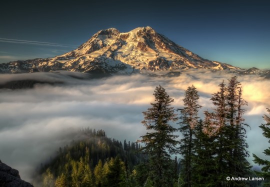
Mount Rainier
Dominating the skyline of Seattle stands the highest peak (4392 m/14411 ft) in the Cascade Mountain Range, Mount Rainier. Along with other notable volcanoes in the Cascades, Mount Rainier formed as a result of subduction along the Cascadia subduction zone, where melting and crustal contamination generates a high silica, high water content magma. This magma composition presents at the surface in a very particular way; large stratovolcanoes with the potential for large, explosive eruptions.
Located on the leading edge of the Cascades, Mount Rainier is located just 87 km/54 miles to the south-east of Seattle. Parts of the city of 634,535 people, as well as the city of Tacoma (202,010 people) and surrounding towns are built on ash and lahar deposits from Rainier.
Along with the 20 or so major stratovolcanoes in the Cascade Arc, Rainier is capable of large, explosive eruptions similar to that of Mount St Helens in 1980. The geologic record shows that continuous eruptions have been occurring at Rainier for 500,000 years, fluctuating between periods of higher and lower eruption rates (We are in the latter).
The eruptions themselves however, are not the only, nor the biggest threat the volcano poses. The mountain is home to 26 major glaciers which feed several rivers (Cowlitz, Nisqually, Puyallup, Carbon and White) that during an eruption would be vulnerable to lahars created by the sudden release of glacial meltwater. The USGS estimates that 150,000 people live on top of past lahar deposits from Rainier, including areas of Seattle and nearby Tacoma.
Hydrothermal alteration on the mountain is also of concern. A mixture of magmatic fluids, hydrothermal fluids, and steam have acted to chemically alter the volcanic rocks, making them weaker in the process. Widespread alteration on the steep sided flanks of Rainier makes them vulnerable to collapse, a process evident in the geological record. Approximately 5,600 years ago, 2-3 km^3 of mostly altered material from the summit and N-E flank detached from the mountain, creating a lahar that reached as far as the Puget Sound. This event, known as the Osceola Mudflow, created a horseshoe shaped crater not unlike that created after Mt St Helens erupted, which has since refilled with later lavas. Most of the heavily altered rock from the volcano was removed in this event, but some does remain on the upper west flank and presents a collapse hazard. These flank failure events can prove particularly hazardous as they do not necessarily require volcanic or seismic activity to occur; instead failing due to their own structural weakness.
There are no current signs of renewed activity at Mount Rainier, which is heavily monitored for any activity that suggests the contrary. Rainier has not had a major eruption in recent times, but its eventual awakening will no doubt make headline news worldwide.
USGS: Mount Rainier - http://on.doi.gov/PctRUI
Hydrothermal Alteration on Rainier - John, D. A., Sisson, T. W., Breit, G. N., Rye, R. O., & Vallance, J. W. (2008). Characteristics, extent and origin of hydrothermal alteration at Mount Rainier Volcano, Cascades Arc, USA: Implications for debris-flow hazards and mineral deposits. Journal of Volcanology and Geothermal Research, 175(3), 289-314. - http://bit.ly/1hdKn4Q
The Osceola Mudflow - Vallance, J. W., & Scott, K. M. (1997). The Osceola Mudflow from Mount Rainier: Sedimentology and hazard implications of a huge clay-rich debris flow. Geological Society of America Bulletin, 109(2), 143-163. - http://bit.ly/1KKcmWy
Deep magma reservoir below Mt Rainier - http://on.fb.me/1IECxvm
Image Credits - Andrew E. Larsen - http://bit.ly/1OY1nrh, Poyson - http://bit.ly/1Hj5zvd, Hazard Map - USGS http://on.doi.gov/1JG1p6W
RJW
#mount rainier#science#volcano#lahar#geology#hazard#volcanomonday#washington#pnw#tacoma#the earth story
102 notes
·
View notes
Photo

Mt Osceola, White Mountains, New Hampshire
18 notes
·
View notes
Text


Had an incredible hike yesterday. Maya did so good and I can feel the trust and relationship growing as we have more adventures together.
As we reached the summit the wind died and the sun came out, and even though we saw plenty of people on the trail, the peak was empty. Maya and I shared my turkey sandwich in quiet and enjoyed the peace.
Mt. Osceola & East Osceola, NH
14 notes
·
View notes
Text
Fully licensed & insured pressure washing company in the Orlando Fl area.
Fully licensed & insured pressure washing company in the Orlando Fl area. Specialing in paver sealing, home exterior cleaning, as well as rust removal. We are certified paver sealing applicators. Serving Windermere, Winter Garden, Orlando, Gotha, Ocoee, Bay Hill, Doctor Phillips, Lake Buena Vista, Lake Butler, Four Corners, Horizon West, Celebration, Champions Gate, Hunters Creek, Kissimmee, Buena Ventura Lakes, Lake Nona, Narcoossee, Oakland, Tildenville, Clermont, Minneola, St Cloud, Winter Park, Maitland, Goldenrod, Oviedo, Altamonte Springs, Casselberry, Longwood, Winter Springs, Apopka, Mt Dora, Sanford, Davenport, Poinciana Orange County, Osceola County, Lake County, Polk County, Seminole County Central Florida Area, Greater Orlando Area $50 Off Paver Sealing
Top Dawg Power Washing, LLC
7509 Ripplepointe Way Windermere, FL 34786 United States
407-697-8603
http://www.topdawgpowerwashing.com/
Linkedin
1 note
·
View note
Photo

My son documenting the view from the summit of his 2nd 4000-footer, Mt. Osceola, NH, USA https://ift.tt/2O2K1yY
Get 25% off Handmade Travel Art at my Etsy Store!
Follow me on Pinterest for more Travel Content!
14 notes
·
View notes
Conversation
U.S. Daily High Temperature Records Tied/Broken 8/7/22
Anaheim, California: 98 (previous record 97 2018)
Channel Islands National Park, California: 95 (previous record 92 2018)
San Isabel National Forest, Colorado: 86 (previous record 84 2018)
New Hartford, Connecticut: 91 (previous record 89 2018)
New Haven, Connecticut: 92 (previous record 91 1977)
Norfolk, Connecticut: 88 (also 88 2018)
Boca Chica Key, Florida: 95 (also 95 2021)
Unincorporated Hillsborough County, Florida: 95 (also 95 2017)
Plant City, Florida: 98 (also 98 2021)
Tarpon Springs, Florida: 97 (previous record 96 2017)
Unincorporated Maui County, Hawaii: 95 (previous record 93 2019)
Elizabeth Township, Illinois: 91 (also 91 2001)
Gladstone Township, Illinois: 93 (previous record 92 1996)
New Boston Township, Illinois: 93 (previous record 92 2006)
Guthrie Center, Iowa: 99 (also 99 2001)
Osceola, Iowa: 98 (also 98 1980)
Williamsburg, Iowa: 99 (also 99 1920)
Belmont Township, Kansas: 113 (previous record 109 1970)
Manhattan Township, Kansas: 102 (previous record 101 2000)
Plainville Township, Kansas: 109 (also 109 1946)
Plymouth Township, Kansas: 106 (also 106 1964)
Russell Township, Kansas: 107 (also 107 1970)
Caribou, Maine: 89 (also 89 2001)
Millinocket, Maine: 92 (previous record 91 2001)
Portland, Maine: 96 (previous record 93 2018)
Barre, Massachusetts: 98 (previous record 97 2018)
Bedford, Massachusetts: 97 (previous record 95 1949)
Boston, Massachusetts: 98 (previous record 97 2018)
Brockton, Massachusetts: 99 (previous record 96 2001)
Buffumville State Park, Massachusetts: 94 (previous record 91 2018)
Great Blue Hill summit, Massachusetts: 95 (also 95 1924)
Lowell, Massachusetts: 97 (also 97 1965)
Middleton, Massachusetts: 96 (also 96 1996)
Nantucket, Massachusetts: 85 (previous record 84 1980)
Norton, Massachusetts: 93 (previous record 92 2018)
Walpole, Massachusetts: 96 (also 96 2001)
Worcester, Massachusetts: 93 (previous record 90 1965)
Franklin, Nebraska: 100 (previous record 99 2012)
Hudson, New Hampshire: 96 (previous record 92 2018)
Londonderry, New Hampshire: 96 (also 96 2001)
New Brunswick, New Jersey: 94 (also 94 2018)
Malone, New York: 90 (also 90 2001)
Niagara, New York: 90 (previous record 88 2005)
North Tonawanda, New York: 92 (previous record 90 2001)
Wappinger, New York: 97 (also 97 2001)
Monclova Township, Ohio: 95 (previous record 94 2001)
Vienna Township, Ohio: 93 (also 93 2001)
Unincorporated Benton County, Oregon: 95 (also 95 2005)
Calvert Peak summit, Oregon: 91 (previous record 89 2017)
Cannibal Mt. summit, Oregon: 86 (previous record 85 1996)
Unincorporated Josephine County, Oregon: 100 (previous record 99 2017)
Klamath Falls, Oregon: 94 (also 94 2001)
Unincorporated Lane County, Oregon: 92 (previous record 90 1986)
Mt. Hood National Forest, Oregon: 95 (previous record 94 2018)
Mt. Stella summit, Oregon: 96 (previous record 93 2017)
Rye Mt. summit, Oregon: 98 (previous record 94 1996)
Santiam State Forest, Oregon: 89 (previous record 86 1996)
Siuslaw National Forest, Oregon: 88 (previous record 83 2018)
Squaw Peak summit, Oregon: 91 (previous record 85 2012)
Sugarloaf Peak summit, Oregon: 93 (previous record 90 1996)
Umpqua National Forest, Oregon: 101 (previous record 99 2000)
Willamette National Forest, Oregon: 97 (also 97 1996)
Providence, Rhode Island: 95 (also 95 2001)
Unincorporated La Salle County, Texas: 106 (also 106 2015)
St. Croix, U.S. Virgin Islands: 93 (also 93 2020)
Berlin, Vermont: 89 (also 89 2001)
Lincoln, Vermont: 87 (previous record 85 2018)
Mt. Mansfield summit, Vermont: 79 (previous record 77 1965)
Newport, Vermont: 91 (also 91 1947)
Cougar Mt. summit, Washington: 80 (previous record 78 2018)
Unincorporated Grays Harbor County, Washington: 81 (previous record 80 1989)
Mt. Rainier National Park, Washington: 78 (also 78 2019)
Snoqualmie National Forest, Washington: 79 (previous record 78 2012)
Adams, Wisconsin: 92 (also 92 1930)
Germantown, Wisconsin: 91 (also 91 2001)
Montello, Wisconsin: 93 (also 93 1984)
#U.S.A.#U.S.#Connecticut#Florida#Illinois#1990s#Iowa#1980s#1920s#Kansas#1940s#1970s#1960s#Massachusetts#Nebraska#New Hampshire#New Jersey#New York#Vermont#Washington#Wisconsin#1930s#Colorado#Oregon#Texas#Maine#Rhode Island#Ohio#Hawaii#U.S. Virgin Islands
0 notes
Photo

Mt. Hope Cemetery, Osceola 2013 or earlier. (at Mount Hope Cemetery) https://www.instagram.com/p/Cax2KgXuq5y/?utm_medium=tumblr
0 notes
Photo


Mt. Osceola.
78 notes
·
View notes
Text

Visit Buck Family Dentistry for Teeth Whitening, Inlays and Onlays, Dental Crowns, Dental Bonding, and Teeth Veneers treatment. We accept the patients from Afton, Lenox, Mt. Ayr, Greenfield, Corning, Osceola, and Creston, IA.
Buck Family Dentistry
0 notes
Last Seen Blogs

stand-up-champions-tonight13
Danielle Taylor

ozqequrbuz
sosyalleşmek çok zor

mkdesignsph
MK Designs Graphic Services


the-stoic-goat
The Stoic Goat