#Porlock Weir
Text

This week is a selection of photos from last week's full moon & the very high tide it created at Porlock Weir. First a shot of the full harvest moon itself....
📸 @garyholpinphoto
Click on photo
#@garyholpinphoto#Daily Photos#Monday Motivation#The Photo Hour#Full Moon#Harvest Moon#Porlock Weir#Night Sky#Nature#Travel#Photography
1 note
·
View note
Text
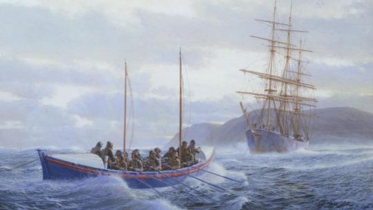
A Remarkable Overland Trek
When lifeboatmen from the #RNLI dragged their boat 13 miles to rescue the stricken Forrest Hall
Built and launched in Liverpool in 1883, the Forrest Hall was a three masted, iron hulled ship, 277 feet long with a gross tonnage of 2.052, capable of carrying over 3,000 tons of coal in her hold. In early January 1899 she set out from Avonmouth Docks to Liverpool for a refitwithout cargo, only ballast, and with a skeleton crew of eighteen including five apprentice sailors instead of its usual…
View On WordPress
#Jack Crocombe#Lynmouth Lifeboat station#Porlock Weir#Royal National Lifeboat Institution#the Forrest Hall#the Jane Joliffe#the Louisa#Tom Pollard
0 notes
Text
Porlock Weir at Spring Tide

View On WordPress
0 notes
Text
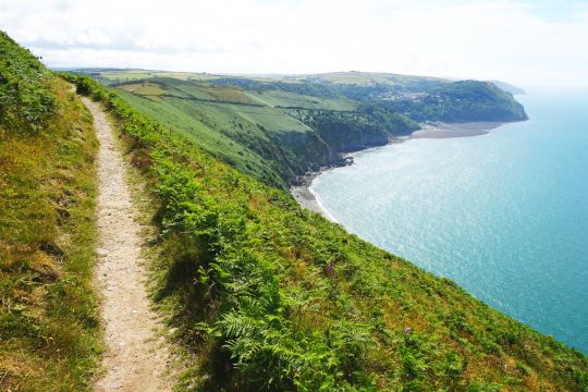
South West Coast Path - Porlock Weir to Lynmouth
South West Coast Path – Porlock Weir to Lynmouth
One day walking the stunning South West Coast Path between Porlock Weir to Lynmouth, part of the 1,014km long marked footpath, the longest in England. Designated as a national trail in 1978 it has steadily gained in popularity, and is regularly voted the best walking route in the country. After this taster I’d be keen to return for more. It takes about eight weeks to walk around the coast of…
View On WordPress
#Countisbury#Culbone Church#day hike#day walk#Foreland Point#Foreland Point Lighthouse#Hiking#photography#Porlock Weir to Lynmouth#South West Coast Path#St Beuno#travel#UK#walking
4 notes
·
View notes
Text
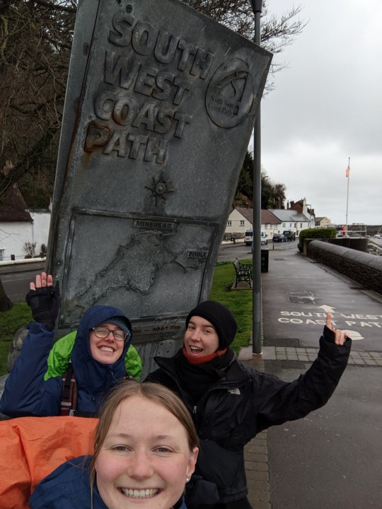
A snowy adventure (day 1-3)
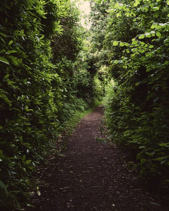
It all started out well, when the three of us (Sofia, Rosa and I) left our Airbnb in Dunster in time to catch the 8:41 bus taking us to the start of the trail, Minehead. After buying our instant mac and cheese for dinner and some lunch snacks we were ready to go. Sofia joined us for the day, unfortunately she couldn't hike with us longer because her foot (previously broken) started to hurt again. We took a picture by the start of the trail and off we went into the woods. Thanks to the brochure "Did you know XX fact about Exmoore National Park?" in our Airbnb, we now knew that this was the only wooded coastline in England. And it was stunning. The forest looked lush with lots of branching tree stems, evergreen climbing plants and ferns covering the ground. As we climbed higher, the views we got of the sea to our right got better and better. We left the forest and took a break on a hill covered in red withered fern, green grass, and yellow goarse bushes. When I threw away my apple core into the goarse I got a criticizing look from Rosa with the words "leave no trace". Right: From now on this will be our life motto while we wild camp on the South West Coast Path (next to "pitch late leave early").

We said goodbye to Sofia after a break on the beach in Porlock Weir and made our way back into the forest onto the next hill, where we started to look for a camping spot. We found a perfect spot about one hour too early (see picture) but we enjoyed the view of the coastline, to where the trail would still lead us, from there. Our actual camp was directly next to the path and we were afraid somebody might pass but nobody did. Actually, we had seen almost no people on the path so far. Rosa waved me over and said "wow, look at the setting sun", "wow, beautiful!" I said, looking at the red ball hovering just over the horizon. Two minutes later, I looked again in awe. Then two minutes later again... wait.. the sun had moved up, not down. It wasn't the sun it was the rising moon!


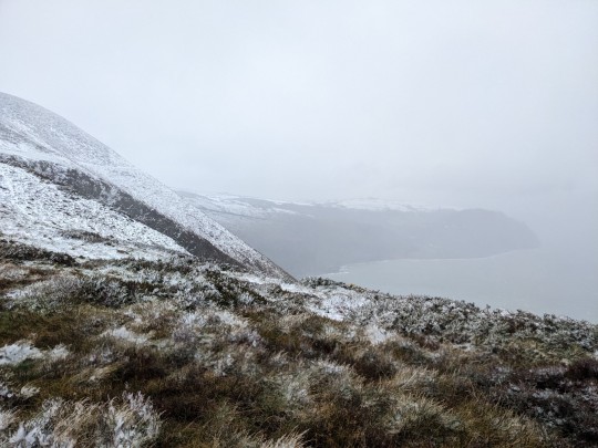
The next mornig our tent was wet and had a little bit of snow on it of which I proudly took a picture. It was raining, so we were expecting the snow to disappear soon, but as we got higher and higher the rain turned into snow and soon the trees, bushes, and paths were covered in a thin layer of snow. We got to an area without trees and the wind picked up, luckily it was in our backs. Then, however, we had to take a turn to the left, and now we had to fight really hard against the wind, coming from the front left. The sea, which had been hidden from our sight before, appeared from beind a mountain to our right. It was foggy, and the snowy ground, the sea, and the grey sky melted together to one. To the left there was a way mark and a low wall (typical for an animal fence), to the right the path continued around a hill, as far as we could see right along the cliff. We communicated with handsigns that we would shelter behind the wall and talk. Puh.. we had a moment of rest to eat a muesli bar, and take a look on the map. We decided not to follow the path along the cliff bit to take an alternative path along the wall (sheltered but with deep snow) and over the hill.
"We have to go to the church!" Rosa shouted and pointed at it, when we were past the top of the hill. The snow was deeper here, and through goarse bushes we were making our way there. Unfortunately, the snow got into our shoes at this point. At the church we saw that the coast path continued further along the cliff. On the map, a pub was indicated somewhere to the left, but only a few houses were to be seen. We tried to reach it anyways, as we desperately needed it. Would it be open or not? We approached the "Blue Ball Inn", it did exist - that was great - but no smoke came from the chimneys. "Open all day" it read on a sign, but the windows were dark. The door opened, all tables were empty, "What can I get you?", the receptionist and bartender asked? "Tea, please", I said relieved, and Rosa said "For me too, please". Wohoo! We attempted to dry our shoes by the fire which the bartender lit soon after our arrival but it had little use. The bartender said that all tables for lunch had been canceled due to the weather exept for one, but soon some other guests arrived, seemingly locals. We also ordered some food and ended up staying for 2,5 hours. The Blue Ball Inn saved us!

In the meanwhile we had checked the map and saw that there were several alternative ways to get to Lynton, our goal of that day. We asked a friendly old couple at the table next to us which path they would recommend and they said that the one along the river Lyn would be lovely. We walked through the windless and actually beautiful valley relieved. We learned from signs along the way that the Lyn is protected by law!
In Lynmouth it was still raining and we were looking for a supermarket. Somebody walking past us said "You are not really camping out there with this whether, are you?". "Yes, we are" Rosa said. "Well, really adventurous you are then", the man said. "Yes yes", Rosa said smiling nervously.
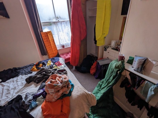
We started walking into the woods again and after a while started looking for a camping spot. The spot where we ended up was far from ideal, it was again right next to the path and quite close to a couple of houses, but our legs (at least mine) were too tired to keep looking. Setting up the tent and eating dinner in the rain was not a lot of fun. I also found out that my sleeping bag got wet despite three layers of presumed waterproof fabric around it. We decided that we needed a BnB to dry evenything and also to recover from this slightly horrible day. The night was okay after all, and quite warm.
The next morning after we woke up at 5:30 we wanted to go to a public bathroom we had seen on the map. "Let's go", we both said and started walking into different directions. "Huh, I thought we have to walk back, we already passed it" "No I think we have to go straight, it still has to come". A look on the map clarified the situation and we could laugh about it. In the bathroom we filled up our water bottles, reordered our backpacks sheltered from the rain (yes, it was still raining) and called the BnB.
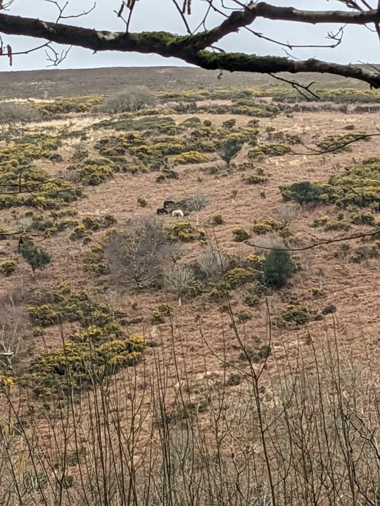
It was good that we got up so early because it turned out we would have the hardest day on the entire path in front of us with 800 ascension meters is total. Why did those rivers have to decide to flow into the ocean right were we walking?? This meant we had to go up and down and up and down again. Anyhow, the views form up the cliffs were beautiful and my personal highlight was that we saw five wild exmoor ponies that day. It was also only raining half the time, just enough to still keep our rain-pants on all the time.

Exhausted we arrived at the BnB in Combe Martin. We hung out all our stuff to dry, took a shower and even did some washing. The next day was going to be a sunny day so the clothes could dry on our backpacks. That night we slept really well.
4 notes
·
View notes
Text
Best Sea Fishing Spots in Somerset
Somerset, nestled in the heart of South West England, is a haven for sea fishing enthusiasts. With its diverse coastline comprising of beaches, harbours, and piers, Somerset offers an array of options for anglers seeking an exciting fishing experience.
Blue Anchor Bay
Situated between Minehead and Watchet, Blue Anchor Bay stands out as a picturesque location enticing both shore and boat anglers. Its varied seabed, adorned with sand, gravel, and reefs, hosts a plethora of fish species such as bass, cod, mackerel, and plaice.
Brean Beach
A long stretch of sandy beach near Burnham-on-Sea, Brean Beach is a popular haunt for shore anglers. High tide brings the fish closer to the shore, offering opportunities to catch bass, mackerel, and cod in abundance.
Berrow Beach
Adjacent to Brean Beach, Berrow Beach is favoured by shore anglers despite its strong currents. Bass, mackerel, and cod are frequent catches here, making it a spot not to be missed for fishing enthusiasts.
Burnham-on-Sea Pier
In the heart of Burnham-on-Sea, this pier serves as a hotspot for both shore and boat fishing. During high tide, the proximity of fish to the shore ensures anglers a rewarding catch, with bass, mackerel, and cod being common sights.
Minehead
Minehead’s beach and nearby rocky areas offer a diverse range of species including bass, rays, and flatfish, making it a preferred destination among sea anglers.
Porlock Weir
Renowned for its scenic beauty, Porlock Weir presents excellent sea fishing opportunities. The rocky coastline and nearby estuary create an ideal environment for catching bass, mackerel, and pollack.
Watchet
Watchet's picturesque harbour and rocky shoreline make it an excellent spot for sea fishing enthusiasts. The harbour area, in particular, teems with a variety of species, promising an exciting fishing experience.
Lynmouth
Although slightly north in North Devon, Lynmouth's rocky coastline and Lynmouth Bay offer fantastic fishing opportunities for bass, pollack, and wrasse, making it a worthy mention for anglers exploring the Somerset region.
When venturing into the Somerset waters, understanding the tides and currents is paramount due to the strong Bristol Channel tides. Consulting tide tables and being aware of local fishing regulations is crucial.
Additionally, for the most current and specific advice, consider reaching out to local bait shops or fellow anglers who are familiar with the area.
Somerset’s coastline invites both novices and seasoned anglers, promising a memorable sea fishing experience amidst the scenic beauty of South West England.
0 notes
Video
(via Porlock Weir Cottage | Alastair Cummins | Flickr)
40 notes
·
View notes
Photo

High spring tide, Porlock Weir, Exmoor by shaungdavey
1 note
·
View note
Photo

High spring tide, Porlock Weir, Exmoor
#waterfront#quay#boat#shore#harbor#calm#wharf#porlock#weir#exmoor#panoramic#panorama#high water#high
1 note
·
View note
Text

Culbone parish church in Somerset is the smallest of its kind in Britain. It's a good four mile trek from the carpark in Porlock Weir.
#Culbone#St Bueno's Church#Somerset#sacred space#English parish churches#mediaeval churches#Anglican
11 notes
·
View notes
Text

Coffee, toastie and a battery pack recharge by the harbour at Porlock Weir.

A unicorn came to my rescue.

Toll road to the left. Path to the right.


Pretty much 10 miles of this.

And this.

And finally this.

Lynmouth, was I glad to see you.

Porlock Weir to Lynmouth
Packed up the tent. Excellent coffee and cheese toastie at the Porlock Weir gallery and cafe by the harbour in the sunshine. The owner was kind enough to fill my flask and recharge my battery pack for the day ahead. And a trip to the Village stores sorted my broken glasses (I managed to sit on them in the night) with rainbow tape from a purple unicorn. So all set.
Today was 13 miles of gruelling. No rain, for which I’m grateful, but endless b*stard ups and even more b*stard downs. Winding woodland path past an old tollgate, and two chapels, always the sea glittering behind the trees to my right. Up, up, up and finally over properly wild grassy and gorse Exmoor moorlands, the buzzards, kestrels and sparrow hawks circling overhead. And at last, after six hours, Lynmouth appeared around the last cove.
Pitched a tent. Had a shandy in the Beggars Roost. All ok.
2 notes
·
View notes
Photo
Really wanting to back and explore further. . . . #walk #devon #hike #porlock #sonyalpha #sony #sonyalpha7iii #sonyalphauk #sonyphotography #sonyimages #CollectivelyCreate #GameOfTones #love (at Porlock Weir) https://www.instagram.com/p/CRPj7EGhqGR/?utm_medium=tumblr
#walk#devon#hike#porlock#sonyalpha#sony#sonyalpha7iii#sonyalphauk#sonyphotography#sonyimages#collectivelycreate#gameoftones#love
2 notes
·
View notes
Text
This weekend: Celebrating the 125th Anniversary of the Overland Launch
Dates for your diary:
* Friday 12th January 7pmCelebration Concert in Lynmouth. Commencing at the harbour, 125 years to the hour that the Maroons were fired in 1899 [maroons are a specific type of rocket which make a loud bang and bright flash that the RNLI used to use to call the crew to the Lifeboat], then moving to St John’s Church, Watersmeet Road, Lynmouth.
* Saturday 13th January 730am…

View On WordPress
0 notes

Text

364/365/2019. Tree near Porlock Weir . Fountain pen
9 notes
·
View notes
Text
Porlock Weir

#photographers on tumblr#original#lensblr#original photographers#photography#imiging#pws#nikonphotography#nikond80#water
6 notes
·
View notes
Last Seen Blogs

watt-lover
twój-skarbek

gocleverrebelcollectionlove-blog
Untitled

starsbelonginspace
Falsegoatsbeard

amritaworldorg
amritaworld.org

theforsakenopinion
the forsaken opinion