#Rapid Intensification
Text
youtube
Warming seas supercharge existing tropical storms and have caused the Atlantic Basin hurricane season to start earlier and end later.
Rapid intensification has been happening more often than in the previous century.
No two storms are exactly alike – that's one factor which makes hurricane observation so interesting. While Hurricane Idalia was powerful, it was also compact. Its relatively modest footprint was good news for Floridians away from its direct path in terms of wind damage.
#tropical cyclones#hurricane idalia#florida#atlantic basin hurricane season#climate change#rapid intensification#warming seas#corene matyas#chad myers#jake tapper
26 notes
·
View notes
Link
(I think I’ve posted links to a whole bunch of stories just like this over the past few years. But this one has a good infographic and tells the story really well.)

Excerpt from this Washington Post story:
As Hurricane Ian barreled toward Florida this week, it did what six other storms did over the past six years as they approached the United States: It intensified, quickly.
A few factors help account for the shift, including the warming waters — fueled by climate change — that give hurricanes more energy to release through crushing winds and pounding waves. Climate scientists suspect the slow movement of storms like Ian also stems from global warming, giving them a greater opportunity to strengthen and destroy as long as day-to-day conditions remain ripe.
Since 2017, an unprecedented number of storms rated Category 4 or stronger have lashed the U.S. shoreline: Harvey, Irma, Maria, Michael, Laura, Ida and now Ian. They all qualify as “rapid intensification events,” when a storm’s wind speeds increase by at least 35 mph within 24 hours.
These kinds of storms have increased in number in recent decades. Sixteen of the 20 hurricanes over the past two seasons in the Atlantic basin have undergone rapid intensification.Ian was only the latest case when its winds nearly doubled within a 24-hour period, going from a low-end hurricane with sustained 75 mph winds Monday to a Category 3 storm with 125 mph winds Tuesday. Then, as it approached Florida on Wednesday, its winds surged even faster, going from 120 mph around 2 a.m. to 155 mph by 7 a.m.
A hotter ocean, along with low vertical wind shear, have helped drive the rapid intensification of recent storms.
Generally, ocean waters must be above 79 degrees Fahrenheit for a hurricane to develop and persist. In recent decades, the ocean has warmed at record rates because of human-emitted greenhouse gases, making this threshold easier to reach. As Ian was moving away from Cuba, sea surface temperatures were approaching 86 degrees.
Rising global air temperatures also mean that waters, especially in bodies like the bathub-esque Gulf of Mexico, are warming beyond just their surface. The deeper that warmth goes, the more fuel can flow to a slow-moving storm like Ian. The warm seawater evaporates and pumps moisture into the air, which can recondense into storms, clouds and rain.
31 notes
·
View notes
Text

"#HurricaneOtis has intensified by 80 mph in the past 12 hours (from 65 mph to 145 mph). That's the fastest 12 hr intensification rate in the eastern North Pacific (to 180°) in the satellite era (since 1966), breaking the old record of 75 mph/12 hr set by Patricia in 2015."
-- #philklotzbach Meteorologist at CSU specializing in Atlantic basin seasonal hurricane forecasts.
#Hurricane Otis#Atlantic Hurricane Season#Pacific Hurricane Season#Rapid Intensification#Hurricane Intensification#Hurricane Satellites
2 notes
·
View notes
Text
rapid intensification strikes again
Hurricane Otis, which just struck Acapulco last week as I write this, went from a tropical storm to a category 5 hurricane in 24 hours. This is scary because you can’t evacuate major coastal cities every time a tropical storm is nearby, and enormous damage and death can result from this, and it is becoming more frequent.
View On WordPress
0 notes
Text


That's just straightforwardly a visible eye. Jeez.
0 notes
Text
MasterCLass Travel Planner
🌟 Devenez un Expert du Voyage en Seulement 2 Jours ! 🌟
Vous rêvez de percer dans le monde fascinant du tourisme ? Découvrez notre Masterclass Travel Planner! En l'espace de seulement deux jours, plongez au cœur de 4 modules essentiels pour maîtriser le
Deux Jours, Quatre Modules Essentiels
Pour percer dans le Travel planning
Avant de plonger dans les dédales de la communication, de se perfectionner dans la gestion de la relation clientèle, de maîtriser l’art de la planification ou encore de jongler avec les chiffres du budget, il y a une étape cruciale que tout aspirant Travel Planner ne doit pas négliger : la construction d’une offre…

View On WordPress
#Atelier intensif planification de voyages#Budget et finance voyage formation#Communication voyage professionnelle#Compétences essentielles Travel Planner#Cours accéléré tourisme#Cours professionnel Travel Planning#Découvrir le métier de Travel Planner#Deux jours pour devenir expert en tourisme#Devenir Travel Planner en 2 jours#Expertise en planification de voyages#Formation complète Travel Planner#Formation intensive voyage#Formation rapide et efficace voyage#Gestion clientèle tourisme formation#Masterclass 4 modules tourisme#Masterclass planification et budget#Masterclass professionnelle tourisme#Masterclass Travel Planner#Modules clés Travel Planner#Modules formation voyage#Percer dans le tourisme#Planification de voyage masterclass#Profession Travel Planner#Stratégies avancées en tourisme#Techniques avancées tourisme
0 notes
Text
The state of affairs in Palestine
EDIT: This post is now more than a week old. Updated post here.
Israel has ordered an evacuation of northern Gaza over 24 hours. This order affects 1.1 million people. The UN believes this is completely impossible.
Israel's president has said that civilians in Gaza are complicit in Hamas' attacks.
Reminder that around 40% of Gaza's population is 14 or younger.
Egypt has closed its border to Gaza refugees.
The US state department has asked diplomats to avoid talking about ceasefires, deescalation, or an end to violence.
The Israeli Air Force claims to have already dropped around 6000 bombs on Gaza in the past week.
For context on that last stat: when the US destroyed Mosul (in a rapid intensification of its air war) it dropped around 500 bombs a week.
More than three quarters of Israelis blame the Israeli government for the attack and ensuing war, and more than half believe Netanyahu must be removed from power.
8K notes
·
View notes
Text
The seas in the main development region of the Atlantic have already reached temperatures not normally seen until August or September. This has led to the rapid intensification of Hurricane Beryl, which crashed through the Windward Islands on Monday and is now traversing the Caribbean Sea toward Jamaica.
Beryl is, to put it mildly, a freak storm.
From tropical depression to Cat 4 hurricane in 48 hours, then to Cat 5 hurricane (sustained 165+ mph winds) in 24 hours. Holy forking shirt this thing is gonna kill some people.
208 notes
·
View notes
Text
We are still 36 hours out & he is already losing his voice.

This is definitely not the worst storm I've seen & for most Floridians, this isn't our first rodeo by any means, but wow, people are freaking out over this one. Yes, the rapid intensification is bad, but it has been really since Irma. It's not like we didn't know that the waters in the Gulf are like 90 Fahrenheit. This is an effect of climate change.
Prepare accordingly & follow the old adage: you hide from the wind, run from the water. If you are in a flood zone, evacuate now. The rest of you not in storm surge or flooding areas, just calm down & ride it out. If you are on the eastern side of the track (myself included), don't be shocked if there are some tornadoes or tornado warnings.

Be like me & just watch Twister during the hurricane! Also, make sure your extra battery packs are charged. Look for recipes now for Hurricanes just in case you lose wifi.
Also, for the non-Floridians, there will be people out doing stupid stuff. It's Florida. You shouldn't be surprised by this.
#hurricane idalia#hurricane season#hurricane#hurricane rules#tropical storm idalia#idalia#here we go again#tropical storm#life as a floridian#florida life#its a florida thing#rule number 7#hurricane party#twister#ride it out#denis phillips#jim cantore
300 notes
·
View notes
Text
Beryl became a category 4 hurricane overnight. This rapid intensification has never been observed before and you can see how crazy fast it gains power
62 notes
·
View notes
Text
DAY 5851
Hyd,Koh Feb 24, 2024 Sat 7:24 PM
Ef Sheetal Bahl, Birthday
Sunday, 25 February .. and our wishes to you for your special day ..❤️
The advancement in all that do think and make is such a quantum leap that the ol' timers , like me, often wonder , how on earth did we do what we did , knowing now what it takes to do what is to be done ..
All and everything is on the touch of a finger on your mobile or laptop or computer .. there are no ifs and buts anymore .. need .. and the solution is there .. applications for almost all available without thought .. for even thought is being thought of by the application ..
'From the 1940s to the present day, the world has undergone transformative changes across social, technological, and geopolitical landscapes. The aftermath of World War II marked the beginning of the Cold War, shaping global power dynamics. The 1950s saw economic booms and the rise of consumer culture. The 1960s brought social upheaval with civil rights movements and cultural revolutions. Advancements in technology accelerated in the late 20th century, leading to the digital age and internet revolution. The 21st century witnessed globalization's intensification, environmental concerns, and rapid technological innovations, profoundly altering the way societies communicate, work, and interact.'
and that is but a generalisation .. there is more to it than words within italics or quotes .. and the wonder is where is the next generation going and what shall be their impressions on what we wonder on today ..
It happened then it shall happen now and shall in the tomorrow too ..
Contain the progress .. adjust to the new .. many do not even remember the days gone by .. or if they do it is always ..
" those were the days my friend " !!
Blessed then to have seen and been a part of the past and now the present .. forget the comparisons .. they shall ever intrigue us .. as it will for them that come after us ..
My love

Amitabh Bachchan
105 notes
·
View notes
Text

Low Energy Tropical Depression Storm Don is attempting a comeback in the middle of nowhere in the Mid Atlantic. It currently looks like it may end up just going in a circle. Sad!
For updates on Don and other potential disturbances, visit the National Hurricane Center.
Warm seas act like jet fuel for tropical cyclones. And waters off the coast of Florida are at record temperatures.
Climate scientists are alarmed by record water temperatures off Florida's coast
Water temperatures typically average about 88 degrees in the summer. Now they're about five degrees higher. Water just offshore in Florida Bay near the Upper Keys hit 98 degrees last week. So that is literally hot-tub hot.
[ ... ]
It's bonkers. I don't know how else to put it. It's out of bounds from what we've seen. If you just wrote a statistical model and said what are the chances of this level of warming, it would be 1 in 250,000 years that that would happen.
[ 88° F = 31.1° C, 93° F = 33.8° C, 98° F = 36.6° C ]
What's just as "bonkers" is that Florida has a climate denying governor who dismisses such observations as "politicizing the weather". Floridians need to turn up the heat on Ron DeSantis. People in parts of Florida are still recovering from Hurricane Ian and are now suffering due to extreme heat which potentially enables rapid intensification of storms.
#tropical depression don#low energy#2023 atlantic basin hurricane season#record warm seas#hurricane ian#rapid intensification#climate change#florida#ron desantis#climate denial#republicans
2 notes
·
View notes
Text
7x03 analysis part 2 — Too many Cats
Tommy flew a helicopter into a Category 5 hurricane, at least the show told us so. Is it even possible for an aircraft to fly in those conditions? Today, we are going to figure out just how strong the storm actually is canonically, and how realistic our beloved weewoo show is.
TW: Hurricane, extreme weather, natural disaster
What is the difference between a tropical storm and a hurricane? What even is a hurricane?
Both tropical storm and hurricane are tropical cyclones, just of different strength. A tropical cyclone is a rotating storm system with a low pressure center. The center, or the eye of the storm, sucks in warm moist air from an oceanic environment and it feeds into the generation of storm clouds that organize themselves into a spiral pattern due to the Earth's rotation, aka Coriolis effect.

A tropical cyclone is classified by its maximum sustained wind.

So if it's below 62 km/h, it's a tropical Depression. if it's between 63-118 km/h, it's a Tropical Storm. A Category 5 hurricane though has a maximum sustained wind speed of over 252 km/h.
A strong enough tropical cyclone is called a hurricane in North America, a typhoon in East Asian, and a cyclone in the Indian Ocean (including Australia).
How strong is the storm in 7x03 actually?
We first see the storm at the end of 7x01, when First Mate Kenneth tells Captain Ochoa there is a strengthening tropical storm in the ship's path. Captain Ochoa decides to reverse course back to LA and instructs Kenneth to alert the Coast Guard, but they get interrupted by the cartel.

Fast forward to 7x02, the next mention of the storm comes from Karen. When Hen is sent home by Chief Simpson, she tries to call Athena, but it goes straight to voicemail. Karen tells her cell service is probably spotty out at sea because of the hurricane, which has just got upgraded.
It's recently upgraded to a Category 2 hurricane, as we can see from Karen's tablet.
Then Hen goes to Maddie to ask the Coast Guard to look for Bathena's cruise ship. When Hen shows Maddie the ship tracking app on her phone, the time is 10:28. (I'm guessing PM because it's already dark outside during the Kyle Ortiz call.)

By the time Chief Simpson comes by to reinstate Hen, she's already talking about a Cat 5 hurricane. That can't be more than an hour or two later.

So which one is it? Is it a Cat 2 or a Cat 5? Who should I trust?
Tommy. Whenever he flies, his safety depends on his understanding of the local wind condition and weather. You should listen to him:
So it's a Cat 5, at least by the time the 118 set off on their journey to save Bathena.

Can a tropical storm intensify into a Cat 5 hurricane in hours?
No, not in real life. The record for most rapid intensification of a tropical cyclone is Hurricane Patricia in 2015, but it still took 24 hours. This doesn't mean the storm in 7x03 is completely made up. I believe I might have found the real life inspiration behind it.
Hurricane Otis (2023)
An area of low pressure formed on October 15, 2023 over the Pacific Ocean off the coast of Mexico. While it was during a significant El Niño period and the ocean temperature was record-breaking-ly high, strong vertical wind shear condition near the storm was predicted to hinder its development. It was originally forecasted to make landfall as a mere tropical storm. People in Acapulco went to bed on October 23 expecting moderate wind and light rainfall, many stopped seeking out updates of the storm.
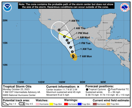
In the early hours of October 24, meteorologists at the NHC recognized from satellite images that tropical storm Otis was rapidly intensifying into a hurricane. The NHC officially upgraded the storm to a Cat 1 hurricane at 13:00 CDT and sent out a hurricane hunter aircraft to accurately measure the actual wind speed of the cyclone.
youtube
Satellite images provide a pretty good model to estimate the strength of a tropical cyclone, but the most reliable way to measure wind speed is still to fly an aircraft into it and physically measure it. When the hurricane hunter managed to fly into the eyewall of Otis, everyone realized they made a huge mistake: Otis had already become a Cat 3 hurricane, and it was expected to strengthen even more. It takes time to process data received from the hurricane hunter, so operationally the NHC still classified Otis as a Cat 1 hurricane until the next advisory was scheduled to come out, which was at 16:00 CDT, but by that time, Otis was already near Cat 4 strength. It was then officially upgraded to a Cat 5 hurricane at 22:00 CDT.

While Otis did take around 24 hours to intensify from a tropical storm to a catastrophic hurricane, if you just look at the NHC advisories, it pretty much jumped from a Cat 1 into a Cat 5 in 9 hours. It caused extensive damage to Acapulco when it made landfall because the city was severely underprepared. I suspect the cruise ship disaster arc was inspired by hurricane Otis because it happened just a month after the writer strike ended. Also, in 7x02 Maddie, a 911 dispatcher, was not aware that the tropical storm had already strengthened into a hurricane, which mirrors the unexpected development of hurricane Otis.

As the storm in universe was going back at sea and not making landfall, the authority was probably in even less of a hurry to find out what the actual strength of the cyclone was. So it could take them even longer to send in weather reconnaissance aircrafts. I can imagine the 911-verse version of the storm jumping from a Cat 2 to a Cat 5 officially in mere hours.
Can a helicopter fly in a Cat 5 hurricane?
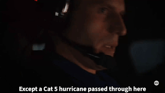
Technically yes, but the chopper won't be doing the flying. The aforementioned NOAA Hurricane Hunter is a Lockheed P-3 Orion specifically modified and fortified for weather information collection. If this four-engined workhorse has to fight tooth and nail against crosswind and turbulence in order to fly into the eye of the storm, a small single engine helicopter definitely would not fair any better. It would end up getting tossed around, a particular strong downdraft might slam it into the ocean, or a prolong bout of severe turbulence might rip it apart. Luckily in 7x03, Tommy is not actually flying into a hurricane, he's trailing behind it.

NOAA Lockheed WP-3D Orion Hurricane Hunter
In a blink-and-you-miss-it exchange between Buck and Tommy, after Tommy says "a Cat 5 hurricane passed through here", Buck asks why he means by "passed through" and what they are flying in at the moment.

"iNTermITteNt sHOweRs"

When looking at the cross section of a tropical cyclone, you can see rows of rainbands around the eyewall, increasing in size the closer it is to the center of the storm. If you have ever experienced a tropical cyclone making landfall, you would know it starts with sporadic bouts of rainfall (aka intermittent showers), which then gradually increase in frequency and severity as the storm approaches. Once you are within 100-200 km of the eye, wind speed would become violent while the rainbands become so wide and close together it basically keeps raining until you are right under the eye.
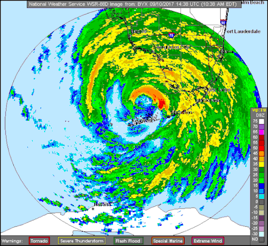
These are radar images of hurricane Irma (2017) making landfall in Florida. Bands of moderate to heavy rainfall spread across the inner core region of the cyclone, with still pretty consistent light to moderate precipitation between the gaps. But in the area further away from the eye in the southwest and southeast quadrants, you can see more squall line like patterns. Precipitation would abruptly begin and stop as you fly in and out of those outer lumps of clouds.
Wind speed in that area is no where near hurricane level even for a Cat 5 cyclone, it is typically under 100 km/h. That does not mean it is a safe condition to fly in. Because the outer rainbands of a cyclone are less affected by the storm's vortex dynamics, they behave more like regular thunderstorms. As you know, thunderstorms are big no-no's for aviation safety. In fact, the outer rainbands of a typhoon once contributed to a plane crash in Taiwan.
Conclusion
The hurricane in 7x03 is likely based on reality, albeit with a bit of exaggeration and a shortened timeline for dramatic effect. It is possible to fly and control a helicopter in this specific condition, but the danger is still quite high. Flying into a thunderstorm has a whole different set of risks associated with it, which I will tell you all about next time. Yes, part 3 of this series is "how to crash a helicopter with weather", so stay tuned.
#not a professional#but storm tracking is my cultural heritage#i'm never beating the dweeb allegation#911 abc#911 meta#tommy kinard#tagging the ship for fic reference#bucktommy#tevan#kinley#TW: hurricane#TW: extreme weather#TW: natural disaster
38 notes
·
View notes
Text
"Interesting study looking at a global trend toward hurricanes that intensify more rapidly and extensively near the coast due to human-caused climate change" -- "Andrew Freedman
@afreedma - Senior climate reporter @axios
#Axios climate coverage#Andrew Freedman#Intensifying hurricanes#Rapid hurricane intensification#hurricane season
0 notes
Text
more evidence for rapid intensification
Anecdotally, we have seen an increase in rapid intensification of hurricanes in recent years. A “new study” (which the journalist does not name or link to, a pet peeve of mine) confirms this using data.
The study looked at 830 Atlantic tropical cyclones since 1971. It found that in the last 20 years, 8.1% of the time storms powered from a Category 1 minor storm to a major hurricane in just 24…
View On WordPress
0 notes
Text
⚠️⚠️⚠️ Hurricane Idalia Update ⚠️⚠️⚠️

Gee I'm not a weather man but I called it to be a cat 4 at landfall... Guess what? 👇

All you have to do is pay attention to what they're doing. Currently there are 3 hurricane hunter planes flying around in the storm. These storms don't go through a "Rapid Intensification" process unless those planes are in it.
Don't let these lying fμ¢%s fool you. If you educate yourself to know your enemy and you pay attention to what the fake news tell you what they're doing, you WILL know.
KNOWLEDGE IS POWER 🤔
#pay attention#educate yourselves#educate yourself#knowledge is power#reeducate yourself#reeducate yourselves#think for yourselves#think about it#think for yourself#do your homework#do your own research#do some research#ask yourself questions#hurricane idalia#hurricane update#hurricane
108 notes
·
View notes
Last Seen Blogs

kry4u
KRY4U

canis-lupas
R a i n

gvhub
Good Vibes Hub

rc-appreciationweeks
#RCHalloweekend

laconchinchina
La Conchinchina